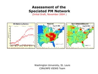
0411 Spec Nat Assess
•Download as PPT, PDF•
1 like•260 views
http://capitawiki.wustl.edu/index.php/20041124_Assessment_of_the_Speciated_PM_Network_%28Initial_Draft%2C_November_2004_%29
Report
Share
Report
Share
![Contents ,[object Object],[object Object],[object Object],[object Object],[object Object],[object Object],[object Object],[object Object],[object Object],[object Object],[object Object],[object Object],[object Object],[object Object],[object Object]](data:image/gif;base64,R0lGODlhAQABAIAAAAAAAP///yH5BAEAAAAALAAAAAABAAEAAAIBRAA7)
Recommended
3-Johnson.pptx
The document summarizes a study analyzing radio frequency interference (RFI) in observations from ESA's Soil Moisture and Ocean Salinity (SMOS) mission. RFI is a major concern for L-band microwave radiometry. The study examines RFI properties in SMOS data, identifies artifacts caused by strong sources and system properties, and explores strategies to reduce artifacts to better understand the true RFI environment. Statistics of the artifact-reduced data still show significant RFI presence, which has implications for planning NASA's upcoming SMAP mission that will also use L-band radiometry.
Towards a concept for the integration of European TCCON sites into the Resea...
Towards a concept for the integration of European TCCON sites into the Resea...Integrated Carbon Observation System (ICOS)
The document discusses integrating European TCCON sites into the ICOS Research Infrastructure. TCCON provides complementary and reference data for satellite validation by measuring total column concentrations of greenhouse gases. Currently, European TCCON sites rely on short-term project funding, threatening continued operations. Integrating sites into ICOS could provide long-term funding and support from a proposed Atmospheric Column Thematic Centre. This would help preserve the network while centralizing quality control, data handling, and supporting innovation to improve satellite validation and calibration efforts. However, some open issues around instrumentation, data exchange, and national funding commitments would still need to be addressed.2003-12-02 Environmental Information Systems for Monitoring, Assessment, and ...
The document discusses environmental information systems for monitoring, assessment, and decision-making. It covers topics like spatial analysis, web-based information systems, sensor webs, spatial interpolation techniques, integrating satellite and surface monitoring data, and developing interoperable environmental information systems. The goal is to improve access to and use of environmental data for applications like air quality mapping and monitoring networks.
Ireland’s Transboundary Monitoring Network and EMEP Strategy - Michael Geever...
Ireland’s Transboundary Monitoring Network and EMEP Strategy - Michael Geever...Environmental Protection Agency, Ireland
This document summarizes Ireland's transboundary air pollution monitoring network and its relationship with the European Monitoring and Evaluation Programme (EMEP). It discusses the background of EMEP and Ireland's initial air quality monitoring efforts. It then describes the development of Ireland's EMEP-compliant transboundary monitoring network between 2004-2009, which established several Level 1 monitoring sites around Ireland. These sites have automated instrumentation to regularly measure air and precipitation quality and transmit data to a central server. The document outlines ongoing work to maintain and improve the network, including instrument upkeep, data analysis, and developing an online data visualization system to share information.IGARSS 2011_Priestley.ppt
CERES Flight Model 5 on NPP was prepared for launch with rigorous pre-launch calibration and testing. Post-launch, independent studies will characterize instrument performance across all scales to validate data products. A strategic approach to data release aims to provide quality-controlled data while supporting continuous calibration improvement.
Sha Mahesh, Kumar: Measurements of greenhouse gases from ground-based remote ...
Sha Mahesh, Kumar: Measurements of greenhouse gases from ground-based remote ...Integrated Carbon Observation System (ICOS)
Ground-based remote sensing networks like TCCON and NDACC measure greenhouse gases like CO2, CH4, and N2O in the atmosphere using Fourier transform infrared (FTIR) spectrometers. These high precision measurements are important for validating satellite measurements of greenhouse gases. Satellite measurements are becoming more abundant but need validation against these ground-based reference networks. The Sentinel-5 Precursor satellite has been validated against TCCON, showing a small bias that is within mission requirements for CH4 and CO measurements. Smoothing effects were also investigated when using different a priori profiles in the validation.INNOVATIVE DISPERSION MODELING PRACTICES TO ACHIEVE A REASONABLE LEVEL OF CON...
Presentation delivered at the Annual Air and Waste Management Association conference in Long beach, California on June 26, 2014.
Innovative dispersion modeling techniques are presented including ARM2, EMVAP and the 50th percentile background concentration. Case study involves peaking engines that are used 250 hour per year. These intermittent sources are required to undergo a modeling evaluation in many states. Current modeling techniques grossly overestimate the emissions from these sporadic sources.
CAMS General Assembly EUMETSAT
EUMETSAT's role in Copernicus and contribution to CAMS
EUMETSAT implements Copernicus activities as agreed with the European Commission, including operations of Copernicus dedicated missions and delivery of Copernicus data and product services. Recent activities include successful launches of Jason-3 and Sentinel-3 and approval of Sentinel-3 aerosol and fire products. EUMETSAT provides various aerosol, trace gas, cloud and other atmospheric composition products from current and future missions like Metop, Sentinel-3, -4, and -5 to support CAMS. EUMETSAT is working to develop multi-sensor synergistic products from its instruments to improve monitoring of atmospheric composition.
Manning_3D_Cloud_ASTM_Fall_2016
This document discusses visualizing cloud data from the Atmospheric Infrared Sounder (AIRS) instrument in 3 dimensions. It describes how AIRS measures cloud properties in each 15km field of view, but provides limited information about cloud structure. The document outlines a method for generating 3D cloud representations by assigning each cloud a shape, depth, and horizontal coverage based on AIRS measurements and other data. Color can also be used to represent different cloud properties. Examples of 3D clouds colored by various properties are shown and comparisons are made between older and newer AIRS cloud retrieval versions. The goal is to more fully characterize clouds and enable comparisons between datasets.
EFFECTS OF MET DATA PROCESSING IN AERMOD CONCENTRATIONS
This document summarizes the results of a sensitivity analysis using AERMOD to model pollutant concentrations from three hypothetical emission sources under nine different meteorological data processing scenarios. The analysis found that: 1) Changing the meteorological station location had a modest effect on modeled concentrations for short and tall stacks. 2) Surface roughness category (urban vs. rural) had the largest effect on concentrations for tall stacks. 3) Varying the anemometer height resulted in small concentration changes, while surface moisture variation did not significantly affect outcomes. 4) For tall stacks, use of AERMINUTE data to include low wind hours led to much higher modeled concentrations compared to excluding this data.
Complying with EPA's Guidance for SO2 Designations
EPA is under a Court order to complete the remaining SO2 designations for the rest of the country in three additional rounds. On March 20, 2015 the EPA released an updated guidance for 1-hr SO2 area designations. The two options included are compliance through dispersion modeling or ambient monitoring. Of these two options, dispersion modeling is the fastest and most cost effective one to characterize SO2 air quality. However, this compliance demonstration can be challenging given that AERMOD tends to produce overly conservative concentration estimates. Source characterization techniques and probabilistic techniques may be used to achieve compliance with the 1-hour NAAQS. Three advanced methods discussed: 1) Equivalent Building Dimensions (EBD); 2) Emission Variability Processor (EMVAP); 3) 50th Percentile Background Concentrations.
AERMOD CHANGES AND UPDATES
Presentation includes information related to gently sloping terrain, AERMINUTE, and EPA formula height.
Presented at the 27th Annual Conference on the Environment on November 13, 2012.
AERMET's Beta u-star Option
This document discusses the beta u-star option in AERMET for adjusting friction velocity (u*) calculations under low wind stable conditions. It provides background on studies conducted by AECOM and EPA to evaluate AERMOD's performance at low wind speeds. The document outlines the timeline of updates to u* in AERMET and reviews AECOM's 2014 evaluation of new meteorological databases using the beta u* option, finding impacts were most sensitive for low-level sources and tall buoyant stacks in complex terrain. It closes with considerations for justifying the beta u* option as an alternative refined model under EPA regulations.
Using Physical Modeling to Evaluate Re-entrainment of Stack Emissions
Fume re-entry is an important concern for many types of facilities such as hospitals and laboratories that emit pathogens and toxic chemicals that may impact public health by being re-entrained into the building though nearby air intakes. Numerical methods can be used to evaluate dispersion of pollutants from stacks at sensitive receptors. However, numerical methods have limitations and simplifications that can significantly affect its predictions. An alternate way of analyzing stack re-entrainment is with physical modeling in a wind tunnel. In such a study, a scale model that accounts for buildings, topography, and vegetation is used with planned and alternate stack designs to determine the toxic emission impacts on air intakes and other sensitive locations. In a wind tunnel study different stack designs and possible mitigation options can be evaluated. This method is superior to numerical methods (e.g., dispersion models) because it accounts for the immediate structures, topography, and vegetation that is often ignored or oversimplified in numerical methods.
This presentation will show a hypothetical case study evaluating a site with toxic air emissions using AERMOD and physical modeling.
CAMS GA Aerosols
The document summarizes the work of the CAMS43 consortium, which includes four partners working to improve the global aerosol monitoring system. It describes the main tasks as improving secondary aerosols and sources, removal processes, data assimilation, and developing an aerosol alert service. The goals are to enhance the representation of aerosols in models and better utilize observational data.
20160614 CAMS GA Acquisition by Suttie
The document summarizes the types of observations acquired for the Copernicus Atmosphere Monitoring Service (CAMS) and how they are obtained. CAMS acquires aerosol, reactive gas, greenhouse gas, and fire radiative power observations from various satellite instruments, including MODIS, OMI, IASI, GOME-2, and Sentinel-5P. The observations are obtained in real-time via the internet, GTS, and EUMETCast and ingested into the ECMWF system using the ECPDS and SAPP systems, which acquire, decode, quality control and format the data for assimilation into CAMS models. An example of the Polar Multi-Sensor Aerosol Optical Properties product
CAMS GS Global Analyses
How are global analyses, forecasts and re-analyses produced? What is the status of the global system?
INNOVATIVE DISPERSION MODELING PRACTICES TO ACHIEVE A REASONABLE LEVEL OF CON...
Presentation delivered at the Board meeting for the Upper Midwest section of the Air and Waste Management Association meeting on September 16, 2014.
Innovative dispersion modeling techniques are presented including ARM2, EMVAP and the 50th percentile background concentration. Case study involves peaking engines that are used 250 hour per year. These intermittent sources are required to undergo a modeling evaluation in many states. Current modeling techniques grossly overestimate the emissions from these sporadic sources.
New Guideline on Air Quality Models and the Electric Utility Industry
The new EPA guideline on air quality models makes several changes, including adopting AERMOD version 16216r as the new default model. It establishes a two-tiered approach for modeling ozone and secondary PM2.5 formation, using existing empirical relationships (Tier 1) or chemical transport models (Tier 2). CALPUFF is no longer preferred for long-range transport modeling beyond 50 km. The guideline also allows the use of prognostic meteorological data in some cases. While the changes aim to promote consistency, the increased flexibility may lead to legal challenges and delays.
EVALUATION OF SO2 AND NOX OFFSET RATIOS TO ACCOUNT FOR SECONDARY PM2.5 FORMATION
On January 4, 2012, the EPA committed to engage in rulemaking to evaluate updates to the Guideline on Air Quality Models (AppendixWof 40 CFR 51) and, as appropriate, incorporate new analytical techniques or models for secondary PM2.5. As a result, the National Association of Clean Air Agencies (NACAA) developed a screening method involving offset ratios to account for
secondary PM2.5 formation. This method can be used to evaluate total (direct and indirect) PM2.5 impacts for permitting purposes. Therefore, the evaluation of this method is important to determine its viability for widespread use.
Pairing aermod concentrations with the 50th percentile monitored value
This document proposes a new method for combining modeled concentrations from AERMOD with monitored background concentrations.
The current practice of adding the maximum or 98th percentile monitored concentration is overly conservative. Instead, the document suggests using the 50th percentile (median) monitored concentration.
Pairing the 98th percentile modeled concentration with the 50th percentile monitored concentration results in a combined 99th percentile concentration. This provides a more conservative estimate than the form of the short-term air quality standards, while avoiding the mismatch of temporal pairing in AERMOD and the influence of exceptional events.
The proposed method is presented as a simple, protective approach for demonstrating compliance with air quality standards when considering both modeled and monitored background concentrations.
NEON Airborne Operations
The document describes the NEON Airborne Observation Platform (AOP) which uses aircraft to collect remote sensing data at fine spatial scales. The AOP uses LiDAR, imaging spectrometers and cameras to measure ecosystem properties. It collects data across the United States at various NEON sites to characterize ecosystems and monitor long-term ecological change. The AOP has conducted test and calibration flights, as well as data collection flights in domains across the US to map areas like forest sites and wildfire burn scars.
Advanced weatherpredictionoct01
This document discusses strategies for adaptive weather observation to improve forecasting. It presents a case study on Hurricane Floyd simulations with different observation strategies:
1. A control simulation with high-resolution observations matched the actual storm track well.
2. A coarse simulation deviated significantly due to lower resolution.
3. Targeted observations around the storm (654 observations) significantly improved the coarse forecast track. Even fewer observations (100 or 50) led to similar improvements.
4. Observations along the predicted track were less effective than initial targeted observations around the storm location.
5. Adaptive observation strategies that focus on high-impact initial observations could dramatically improve forecasts compared to regular observation arrays.
Amy Stidworthy - Optimising local air quality models with sensor data - DMUG17
The document summarizes an optimization technique used to adjust air pollution emissions rates in an air quality model using data from low-cost air quality sensors. The technique develops an inversion method to automatically adjust emissions inputs to improve model predictions against monitored concentrations. Preliminary tests of the technique in Cambridge, UK optimized NOx emissions rates from 305 road sources against data from 20 low-cost sensors and 5 reference monitors. The optimization reduced errors between modeled and monitored concentrations and adjusted emissions profiles and rates in a physically reasonable manner.
Conference on the Environment- GUERRA presentation Nov 19, 2014
This document discusses innovative dispersion modeling practices to achieve reasonable conservatism in regulatory modeling demonstrations. It presents a case study evaluating the Emissions and Meteorological Variability Processor (EMVAP) and approaches to establish background concentrations. The case study models SO2 concentrations from a power plant using 1) constant emissions, 2) variable emissions, and 3) EMVAP. EMVAP provides more realistic concentrations while accounting for emission variability. Using the 50th percentile monitored background concentration when combining with modeled values provides statistical conservatism compared to using high percentile values.
AIR DISPERSION MODELING HIGHLIGHTS FROM 2012 ACE
Presentation includes some highlights from the dispersion modeling papers presented at the Annual AWMA conference in San Antonio, TX. Topics covered include: EMVAP, distance limitations of AERMOD, and two case studies comparing predicted and monitoring data,
Presented at the A&WMA UMS Board Meeting on August 21, 2012.
2003-12-10 Global and Local Dust/Smoke over the US
Global and local air pollution sources have changed over time. Before the 1950s, pollution was mainly from local sources like smoke and fly ash. From the 1970s-1990s, regional pollution increased due to issues like acid rain and haze. Satellite data from the 1990s onward showed evidence of global transport of pollutants like dust and smoke across vast distances. Major sources of global air pollution included dust from deserts in Africa and Asia, as well as smoke from seasonal biomass burning around the world. New monitoring capabilities revealed that global pollutant transport has significant impacts on air quality over regions far from the source.
110105 htap pilot_aqco_p_esip_dc
The document describes the HTAP Data Network, which demonstrates a service-oriented approach to sharing atmospheric model outputs and air quality observations between various data servers using open standards. The main output is open-source WCS data server software and tools that allow different organizations to publish, find, and access distributed air quality data holdings in a interoperable way as part of the GEO Task DA-09-02d: Atmospheric Model Evaluation Network. The network aims to connect air quality data providers and users to enable effective air quality science and management.
Exceptional Event Decision Support System Description
This slideshow is a brief description of the Exceptional Event Decision Support System Description (EE DSS).
2003-10-15 Biomass Smoke Emissions and Transport: Community-based Satellite a...
The document discusses biomass smoke emissions and transport patterns in North America as analyzed using satellite and surface data. Key findings include:
- Four main fire zones were identified based on fire size and distribution: Northern, Northwestern, Southeastern, and Mexican.
- Peak fire seasons vary by region, from December to February in Mexico to June to August in Northern Canada and Northwest US.
- Smoke emission and concentration patterns were measured and modeled using various data sources and models. Near-source and distant smoke transport patterns were estimated.
- Characterizing smoke fully requires describing multiple properties including location, time, particle size, composition, shape, and mixtures - a challenge given sparse measurement data.
More Related Content
What's hot
Manning_3D_Cloud_ASTM_Fall_2016
This document discusses visualizing cloud data from the Atmospheric Infrared Sounder (AIRS) instrument in 3 dimensions. It describes how AIRS measures cloud properties in each 15km field of view, but provides limited information about cloud structure. The document outlines a method for generating 3D cloud representations by assigning each cloud a shape, depth, and horizontal coverage based on AIRS measurements and other data. Color can also be used to represent different cloud properties. Examples of 3D clouds colored by various properties are shown and comparisons are made between older and newer AIRS cloud retrieval versions. The goal is to more fully characterize clouds and enable comparisons between datasets.
EFFECTS OF MET DATA PROCESSING IN AERMOD CONCENTRATIONS
This document summarizes the results of a sensitivity analysis using AERMOD to model pollutant concentrations from three hypothetical emission sources under nine different meteorological data processing scenarios. The analysis found that: 1) Changing the meteorological station location had a modest effect on modeled concentrations for short and tall stacks. 2) Surface roughness category (urban vs. rural) had the largest effect on concentrations for tall stacks. 3) Varying the anemometer height resulted in small concentration changes, while surface moisture variation did not significantly affect outcomes. 4) For tall stacks, use of AERMINUTE data to include low wind hours led to much higher modeled concentrations compared to excluding this data.
Complying with EPA's Guidance for SO2 Designations
EPA is under a Court order to complete the remaining SO2 designations for the rest of the country in three additional rounds. On March 20, 2015 the EPA released an updated guidance for 1-hr SO2 area designations. The two options included are compliance through dispersion modeling or ambient monitoring. Of these two options, dispersion modeling is the fastest and most cost effective one to characterize SO2 air quality. However, this compliance demonstration can be challenging given that AERMOD tends to produce overly conservative concentration estimates. Source characterization techniques and probabilistic techniques may be used to achieve compliance with the 1-hour NAAQS. Three advanced methods discussed: 1) Equivalent Building Dimensions (EBD); 2) Emission Variability Processor (EMVAP); 3) 50th Percentile Background Concentrations.
AERMOD CHANGES AND UPDATES
Presentation includes information related to gently sloping terrain, AERMINUTE, and EPA formula height.
Presented at the 27th Annual Conference on the Environment on November 13, 2012.
AERMET's Beta u-star Option
This document discusses the beta u-star option in AERMET for adjusting friction velocity (u*) calculations under low wind stable conditions. It provides background on studies conducted by AECOM and EPA to evaluate AERMOD's performance at low wind speeds. The document outlines the timeline of updates to u* in AERMET and reviews AECOM's 2014 evaluation of new meteorological databases using the beta u* option, finding impacts were most sensitive for low-level sources and tall buoyant stacks in complex terrain. It closes with considerations for justifying the beta u* option as an alternative refined model under EPA regulations.
Using Physical Modeling to Evaluate Re-entrainment of Stack Emissions
Fume re-entry is an important concern for many types of facilities such as hospitals and laboratories that emit pathogens and toxic chemicals that may impact public health by being re-entrained into the building though nearby air intakes. Numerical methods can be used to evaluate dispersion of pollutants from stacks at sensitive receptors. However, numerical methods have limitations and simplifications that can significantly affect its predictions. An alternate way of analyzing stack re-entrainment is with physical modeling in a wind tunnel. In such a study, a scale model that accounts for buildings, topography, and vegetation is used with planned and alternate stack designs to determine the toxic emission impacts on air intakes and other sensitive locations. In a wind tunnel study different stack designs and possible mitigation options can be evaluated. This method is superior to numerical methods (e.g., dispersion models) because it accounts for the immediate structures, topography, and vegetation that is often ignored or oversimplified in numerical methods.
This presentation will show a hypothetical case study evaluating a site with toxic air emissions using AERMOD and physical modeling.
CAMS GA Aerosols
The document summarizes the work of the CAMS43 consortium, which includes four partners working to improve the global aerosol monitoring system. It describes the main tasks as improving secondary aerosols and sources, removal processes, data assimilation, and developing an aerosol alert service. The goals are to enhance the representation of aerosols in models and better utilize observational data.
20160614 CAMS GA Acquisition by Suttie
The document summarizes the types of observations acquired for the Copernicus Atmosphere Monitoring Service (CAMS) and how they are obtained. CAMS acquires aerosol, reactive gas, greenhouse gas, and fire radiative power observations from various satellite instruments, including MODIS, OMI, IASI, GOME-2, and Sentinel-5P. The observations are obtained in real-time via the internet, GTS, and EUMETCast and ingested into the ECMWF system using the ECPDS and SAPP systems, which acquire, decode, quality control and format the data for assimilation into CAMS models. An example of the Polar Multi-Sensor Aerosol Optical Properties product
CAMS GS Global Analyses
How are global analyses, forecasts and re-analyses produced? What is the status of the global system?
INNOVATIVE DISPERSION MODELING PRACTICES TO ACHIEVE A REASONABLE LEVEL OF CON...
Presentation delivered at the Board meeting for the Upper Midwest section of the Air and Waste Management Association meeting on September 16, 2014.
Innovative dispersion modeling techniques are presented including ARM2, EMVAP and the 50th percentile background concentration. Case study involves peaking engines that are used 250 hour per year. These intermittent sources are required to undergo a modeling evaluation in many states. Current modeling techniques grossly overestimate the emissions from these sporadic sources.
New Guideline on Air Quality Models and the Electric Utility Industry
The new EPA guideline on air quality models makes several changes, including adopting AERMOD version 16216r as the new default model. It establishes a two-tiered approach for modeling ozone and secondary PM2.5 formation, using existing empirical relationships (Tier 1) or chemical transport models (Tier 2). CALPUFF is no longer preferred for long-range transport modeling beyond 50 km. The guideline also allows the use of prognostic meteorological data in some cases. While the changes aim to promote consistency, the increased flexibility may lead to legal challenges and delays.
EVALUATION OF SO2 AND NOX OFFSET RATIOS TO ACCOUNT FOR SECONDARY PM2.5 FORMATION
On January 4, 2012, the EPA committed to engage in rulemaking to evaluate updates to the Guideline on Air Quality Models (AppendixWof 40 CFR 51) and, as appropriate, incorporate new analytical techniques or models for secondary PM2.5. As a result, the National Association of Clean Air Agencies (NACAA) developed a screening method involving offset ratios to account for
secondary PM2.5 formation. This method can be used to evaluate total (direct and indirect) PM2.5 impacts for permitting purposes. Therefore, the evaluation of this method is important to determine its viability for widespread use.
Pairing aermod concentrations with the 50th percentile monitored value
This document proposes a new method for combining modeled concentrations from AERMOD with monitored background concentrations.
The current practice of adding the maximum or 98th percentile monitored concentration is overly conservative. Instead, the document suggests using the 50th percentile (median) monitored concentration.
Pairing the 98th percentile modeled concentration with the 50th percentile monitored concentration results in a combined 99th percentile concentration. This provides a more conservative estimate than the form of the short-term air quality standards, while avoiding the mismatch of temporal pairing in AERMOD and the influence of exceptional events.
The proposed method is presented as a simple, protective approach for demonstrating compliance with air quality standards when considering both modeled and monitored background concentrations.
NEON Airborne Operations
The document describes the NEON Airborne Observation Platform (AOP) which uses aircraft to collect remote sensing data at fine spatial scales. The AOP uses LiDAR, imaging spectrometers and cameras to measure ecosystem properties. It collects data across the United States at various NEON sites to characterize ecosystems and monitor long-term ecological change. The AOP has conducted test and calibration flights, as well as data collection flights in domains across the US to map areas like forest sites and wildfire burn scars.
Advanced weatherpredictionoct01
This document discusses strategies for adaptive weather observation to improve forecasting. It presents a case study on Hurricane Floyd simulations with different observation strategies:
1. A control simulation with high-resolution observations matched the actual storm track well.
2. A coarse simulation deviated significantly due to lower resolution.
3. Targeted observations around the storm (654 observations) significantly improved the coarse forecast track. Even fewer observations (100 or 50) led to similar improvements.
4. Observations along the predicted track were less effective than initial targeted observations around the storm location.
5. Adaptive observation strategies that focus on high-impact initial observations could dramatically improve forecasts compared to regular observation arrays.
Amy Stidworthy - Optimising local air quality models with sensor data - DMUG17
The document summarizes an optimization technique used to adjust air pollution emissions rates in an air quality model using data from low-cost air quality sensors. The technique develops an inversion method to automatically adjust emissions inputs to improve model predictions against monitored concentrations. Preliminary tests of the technique in Cambridge, UK optimized NOx emissions rates from 305 road sources against data from 20 low-cost sensors and 5 reference monitors. The optimization reduced errors between modeled and monitored concentrations and adjusted emissions profiles and rates in a physically reasonable manner.
Conference on the Environment- GUERRA presentation Nov 19, 2014
This document discusses innovative dispersion modeling practices to achieve reasonable conservatism in regulatory modeling demonstrations. It presents a case study evaluating the Emissions and Meteorological Variability Processor (EMVAP) and approaches to establish background concentrations. The case study models SO2 concentrations from a power plant using 1) constant emissions, 2) variable emissions, and 3) EMVAP. EMVAP provides more realistic concentrations while accounting for emission variability. Using the 50th percentile monitored background concentration when combining with modeled values provides statistical conservatism compared to using high percentile values.
AIR DISPERSION MODELING HIGHLIGHTS FROM 2012 ACE
Presentation includes some highlights from the dispersion modeling papers presented at the Annual AWMA conference in San Antonio, TX. Topics covered include: EMVAP, distance limitations of AERMOD, and two case studies comparing predicted and monitoring data,
Presented at the A&WMA UMS Board Meeting on August 21, 2012.
What's hot (18)
EFFECTS OF MET DATA PROCESSING IN AERMOD CONCENTRATIONS
EFFECTS OF MET DATA PROCESSING IN AERMOD CONCENTRATIONS
Complying with EPA's Guidance for SO2 Designations
Complying with EPA's Guidance for SO2 Designations
Using Physical Modeling to Evaluate Re-entrainment of Stack Emissions
Using Physical Modeling to Evaluate Re-entrainment of Stack Emissions
INNOVATIVE DISPERSION MODELING PRACTICES TO ACHIEVE A REASONABLE LEVEL OF CON...
INNOVATIVE DISPERSION MODELING PRACTICES TO ACHIEVE A REASONABLE LEVEL OF CON...
New Guideline on Air Quality Models and the Electric Utility Industry
New Guideline on Air Quality Models and the Electric Utility Industry
EVALUATION OF SO2 AND NOX OFFSET RATIOS TO ACCOUNT FOR SECONDARY PM2.5 FORMATION
EVALUATION OF SO2 AND NOX OFFSET RATIOS TO ACCOUNT FOR SECONDARY PM2.5 FORMATION
Pairing aermod concentrations with the 50th percentile monitored value
Pairing aermod concentrations with the 50th percentile monitored value
Amy Stidworthy - Optimising local air quality models with sensor data - DMUG17
Amy Stidworthy - Optimising local air quality models with sensor data - DMUG17
Conference on the Environment- GUERRA presentation Nov 19, 2014
Conference on the Environment- GUERRA presentation Nov 19, 2014
Viewers also liked
2003-12-10 Global and Local Dust/Smoke over the US
Global and local air pollution sources have changed over time. Before the 1950s, pollution was mainly from local sources like smoke and fly ash. From the 1970s-1990s, regional pollution increased due to issues like acid rain and haze. Satellite data from the 1990s onward showed evidence of global transport of pollutants like dust and smoke across vast distances. Major sources of global air pollution included dust from deserts in Africa and Asia, as well as smoke from seasonal biomass burning around the world. New monitoring capabilities revealed that global pollutant transport has significant impacts on air quality over regions far from the source.
110105 htap pilot_aqco_p_esip_dc
The document describes the HTAP Data Network, which demonstrates a service-oriented approach to sharing atmospheric model outputs and air quality observations between various data servers using open standards. The main output is open-source WCS data server software and tools that allow different organizations to publish, find, and access distributed air quality data holdings in a interoperable way as part of the GEO Task DA-09-02d: Atmospheric Model Evaluation Network. The network aims to connect air quality data providers and users to enable effective air quality science and management.
Exceptional Event Decision Support System Description
This slideshow is a brief description of the Exceptional Event Decision Support System Description (EE DSS).
2003-10-15 Biomass Smoke Emissions and Transport: Community-based Satellite a...
The document discusses biomass smoke emissions and transport patterns in North America as analyzed using satellite and surface data. Key findings include:
- Four main fire zones were identified based on fire size and distribution: Northern, Northwestern, Southeastern, and Mexican.
- Peak fire seasons vary by region, from December to February in Mexico to June to August in Northern Canada and Northwest US.
- Smoke emission and concentration patterns were measured and modeled using various data sources and models. Near-source and distant smoke transport patterns were estimated.
- Characterizing smoke fully requires describing multiple properties including location, time, particle size, composition, shape, and mixtures - a challenge given sparse measurement data.
2003-09-28 The BigSmoke in New England, July 2002
This document summarizes observations of a large smoke plume that transported smoke from Quebec wildfires to New England in July 2002. Satellite images from MODIS, SeaWiFS, GOES and TOMS show the smoke moving from Quebec across Canada and the eastern US between June 25th and July 11th. Surface observations from ASOS, webcams and METAR stations also detected increased haze and lower visibility in the path of the smoke plume. Regional air quality models simulated the transport of the smoke.
2005-01-08 MANE-VU Status Report on CATT and FASTNET
CATT and FASTNET are inter-RPO projects that provide tools for analyzing aerosol and trajectory data. They have been integrated into the DataFed.Net infrastructure, which provides a variety of web-based applications and data catalogs for accessing, viewing, analyzing, and interpreting fast, current, and slow aerosol and meteorological data.
Geoss Arch Schem 080326rbh
The document discusses the Global Earth Observation System of Systems (GEOSS) architecture for the air quality community. It describes how the architecture links together various components, including GEOSS registries, catalogs, portals, and services to facilitate access to and sharing of earth observation data. The architecture is designed to build on existing systems and accommodate new components over time to provide more comprehensive and coordinated access to air quality data.
2008-04-15 EGU Mtg Vienna Exceptional Events
The document discusses methods for justifying the exclusion of air quality monitoring data influenced by exceptional events such as wildfires. It presents evidence needed to designate data as influenced by an exceptional event, including showing a likely standard exceedance, that the event was uncontrollable, a clear causal relationship between the event and the data, excess over normal values, and that the exceedance would not have occurred without the event. It then gives an example of applying these methods to analyze the influence of 2007 wildfires in Georgia on air quality data.
2004-11-18 Multi-Sensory Detection of Agricultural Smoke
This document discusses using satellite imagery to detect agricultural smoke pollution. It describes an algorithm to calculate aerosol optical thickness from SeaWiFS satellite data. A case study is presented analyzing smoke over Kansas from agricultural burning on April 10-13, 2003. Surface PM2.5 measurements are compared to the satellite-derived aerosol optical thickness values to correlate smoke pollution levels.
100528 satellite obs_china_husar
This document discusses the challenges of characterizing air pollution using remote sensing observations over China. It describes the seven dimensions of data - spatial, height, time, particle size, composition, shape, and mixing - needed to fully characterize air pollution. While each individual observation method or data set has limitations, together they can provide consistent global-scale observations. There remain significant challenges to integrating data from multiple sensors to accurately measure air pollution. International collaboration combining global satellite data with detailed local observations in China may help advance progress in addressing this issue.
2005-04-01 Carbonaceous Aerosol and Smoke over the Eastern US
1. The document analyzes carbonaceous aerosol and smoke patterns over eastern North America using data from surface and satellite observations.
2. Smoke from biomass burning constitutes a significant component of fine particulate matter over North America, particularly in summer, but its spatial and temporal patterns are not fully understood.
3. The analysis aims to better characterize the sources, distribution, and composition of smoke through an integrated assessment of literature and recent observation data.
Energy-Environment Analysis Framework 2
The document discusses biogeochemical cycles, specifically carbon and nitrogen cycles. It analyzes materials and energy flow loops within these cycles. The carbon and nitrogen cycles are natural processes by which carbon and nitrogen are recycled in the biosphere.
121117 eedss briefing_nasa_epa
This document summarizes the Exceptional Event Decision Support System (EE DSS) which uses NASA satellite data and the Navy Aerosol Analysis and Prediction System (NAAPS) model to help with air quality management decisions regarding exceptional events like smoke and dust events. The EE DSS has been developed since 2005 with NASA support and is now ready to serve air quality management at the federal, regional, and state levels. It can automatically detect and analyze events, display relevant data through interactive maps and cross-sections, and its tools have helped explain declines in exceptional event flags and PM2.5 concentrations from 2006-2012. Coordination is proposed with NASA and EPA for continued application of the EE DSS to smoke and dust events in
2004-06-24 Fast Aerosol Sensing Tools for Natural Event Tracking FASTNET Proj...
The document discusses the FASTNET project which aims to better characterize natural haze conditions through the analysis of major natural aerosol events like forest fires and dust storms. The goal is to develop tools for data access, archiving, and analysis to describe the spatial, temporal, and compositional features of natural aerosols. This will help understand their contribution to regional haze and establish baseline natural conditions as required by the Regional Haze Rule.
2003-10-14 Integrated SOx Emission Trend Estimation for the Sustainability Tr...
This document discusses trends in sulfur oxide (SOx) emissions and the drivers of changes over time. It analyzes SOx emissions using a linear causality model with four key drivers: population, economy, energy usage, and emission factors. Since the 1970s, SOx emissions have declined as downward drivers like improved energy efficiency and lower emission factors have dominated over upward drivers like population and economic growth. The causality relationships between these drivers are complex and can be represented with dynamic transfer matrix models. Current industrial sulfur demand is now met primarily through sulfur recovery from fuels and minerals rather than direct mining.
2004-10-14 AIR-257: Satellite Detection of Aerosols Issues and Opportunities
This document summarizes a professional development course on satellite detection of aerosols. The course covers introduction to satellite aerosol monitoring, different satellite types and their usage, detecting aerosol events like fires and dust storms from satellites. It also discusses using satellite data and tools for air quality management, and issues around data retrieval over bright surfaces like clouds that can limit available data. Vertical profiles of different types of aerosols are shown. Examples of using satellite data to monitor smoke plumes are provided. Open questions around distinguishing aerosols and clouds are discussed.
2004-01-21 Continental-Scale Transport of Air Pollutants
This document discusses continental-scale transport of air pollutants across North America. Fine particulate matter can remain in the atmosphere for weeks and be transported over large regions. Major sources of particulate matter include windblown dust, volcanic emissions, industrial aerosols, and smoke from fires. Satellite data shows episodes of transport from Asia, Africa, and Central America impacting air quality over North America. International cooperation is needed to monitor and address transboundary pollution issues.
Viewers also liked (17)
2003-12-10 Global and Local Dust/Smoke over the US
2003-12-10 Global and Local Dust/Smoke over the US
Exceptional Event Decision Support System Description
Exceptional Event Decision Support System Description
2003-10-15 Biomass Smoke Emissions and Transport: Community-based Satellite a...
2003-10-15 Biomass Smoke Emissions and Transport: Community-based Satellite a...
2005-01-08 MANE-VU Status Report on CATT and FASTNET
2005-01-08 MANE-VU Status Report on CATT and FASTNET
2004-11-18 Multi-Sensory Detection of Agricultural Smoke
2004-11-18 Multi-Sensory Detection of Agricultural Smoke
2005-04-01 Carbonaceous Aerosol and Smoke over the Eastern US
2005-04-01 Carbonaceous Aerosol and Smoke over the Eastern US
2004-06-24 Fast Aerosol Sensing Tools for Natural Event Tracking FASTNET Proj...
2004-06-24 Fast Aerosol Sensing Tools for Natural Event Tracking FASTNET Proj...
2003-10-14 Integrated SOx Emission Trend Estimation for the Sustainability Tr...
2003-10-14 Integrated SOx Emission Trend Estimation for the Sustainability Tr...
2004-10-14 AIR-257: Satellite Detection of Aerosols Issues and Opportunities
2004-10-14 AIR-257: Satellite Detection of Aerosols Issues and Opportunities
2004-01-21 Continental-Scale Transport of Air Pollutants
2004-01-21 Continental-Scale Transport of Air Pollutants
Similar to 0411 Spec Nat Assess
City Ambient Air Quality Monitoring
Cities operate ambient air quality monitoring networks but often do not analyze and interpret the data. Data gets simply "stacked". Networks are not configured correctly capturing the data trends and monitoring objectives. This presentation provides guidance and uses Mumbai's ambient air quality data to illustrate application
2005-10-31 Characterization of Aerosol Events
This document summarizes research on characterizing aerosol events using monitoring data. It discusses:
- Long-term monitoring networks that measure particulate matter and species over hundreds of sites
- Tools like analysts' consoles that use spatial and temporal data to help characterize events
- Methods for decomposing temporal signals to identify seasonal, random, and event components
- Examples of analyzing specific aerosol events across the Eastern US using these tools and data.
2013-04-30 EE DSS Approach and Demo
The document describes the Exceptional Event Decision Support System (EE DSS), a tool to help states and EPA regions implement the EPA's Exceptional Events Rule. The EE DSS uses air quality, meteorological, and other data to screen for exceedances and flag those likely caused by exceptional events like dust storms, wildfires, or July 4th fireworks. It aims to minimize the technical hurdles of the EE rule and provide a uniform, transparent methodology. The document outlines the EE DSS's data sources and modeling, screening approach, tools for visualizing events, and provides an example demo of the system in action.
2003-12-04 Evaluation of the ASOS Light Scattering Network
The document reports on an evaluation of the Automated Surface Observing System (ASOS) light scattering network. It analyzes data from 220 ASOS stations to evaluate the precision and performance of the ASOS visibility sensors. It finds that some stations show excellent correlation between duplicate sensors while others show poorer correlation or significant offsets. It also examines diurnal patterns and the effects of relative humidity on visibility readings.
20051031 Biomass Smoke Emissions and Transport: Community-based Satellite and...
The document discusses biomass smoke emissions and their characterization using multiple data sources and dimensions. It notes that fully describing particulate matter concentrations requires data on 8 dimensions including spatial, temporal, particle size, composition, shape, and mixtures. Characterizing smoke through different instruments and networks provides only a partial view of these dimensions. The challenges of integrating satellite, surface, and model data on smoke are discussed.
2005-11-12 Characterization of Aerosol Events using the Federated Data System...
This document discusses the characterization of aerosol events using a federated data system called DataFed. It describes natural and exceptional event rules for air quality monitoring, long-term monitoring networks for particles, the evolution of spatial coverage for sulfate monitoring, detection of aerosol events using signal decomposition, seasonal patterns and composition of events by region, and tools for exploring air quality data through DataFed.
0507 Event Analysis 051101 Event Seminar2
http://capitawiki.wustl.edu/index.php/20051112_Characterization_of_Aerosol_Events_using_the_Federated_Data_System%2C_DataFed
Who are cams users today by Popp
The document provides an overview of the usage statistics for various atmospheric composition and air quality services from 2015 to early 2016, showing increases in the number of users and requests for most services, including global and regional near real-time analyses and forecasts, greenhouse gas flux inversions, and anthropogenic emissions data. It also outlines examples of how the data has been used by the IPCC, UNFCCC, and academic researchers, as well as feedback from users praising the regional ensemble forecast data.
Learn the Tricks to Get the Best from Your City Ambient Air Quality Monitorin...
Cities operate ambient air quality monitoring networks but often do not analyze and interpret the data. Data gets simply "stacked". Networks are not configured correctly capturing the data trends and monitoring objectives. This presentation provides guidance and uses Mumbai's ambient air quality data to illustrate application
FR2.L10.1: MONITORING SMOS BRIGHTNESS TEMPERATURES AT GLOBAL SCALE. A PRELIMI...
This document summarizes ECMWF's objectives and implementation of assimilating SMOS soil moisture data into its forecasting system. It outlines challenges including data volume, latency, and modeling errors. Preliminary analyses show large departures in mountainous areas and areas affected by RFI or snow. Monitoring products help identify systematic differences compared to observations, providing information from SMOS's multi-angular measurements. Ongoing work includes improving the data handling and developing bias corrections to better use SMOS's unique observation capabilities.
Are ultrafine particles important? - Paul S. Monks
Ultrafine particles (UFPs) are an air quality challenge due to their small size and complex behavior in the atmosphere. While their health impacts are not fully understood, epidemiological studies suggest UFPs may independently affect health beyond other regulated pollutants like PM. Combustion sources like traffic are major emitters of UFPs. Measurements show high spatial variability of UFPs and that controlling larger particles does not necessarily reduce UFP levels. More research is needed to better characterize UFP emissions, exposures, and impacts to potentially regulate them specifically.
Iapetus.rawfie
This document proposes a system called IAPETuS that would use drones equipped with air quality sensors to monitor pollution levels in protected natural areas. It notes that current legislation requires regular monitoring of pollutants like PM and NOx. The system would collect data in real-time, store it in the cloud, and use it to alert authorities about pollution levels. A work plan outlines using different types of drones to inspect large and small areas, with the goal of developing tools and best practices for monitoring critical environmental sites. The impact would be maximizing awareness and commercial potential of the RAWFIE drone platform for air quality monitoring.
Rawfie kickoff 20150523
Gathering of air pollution data in real time and
storing them in a database for further use
using them for real time alerting system
would be the key step in developing an Air Quality Management (AQM) system
Easy to create a bouquet of services will be a primary need of specific areas management agencies and their funding bodies (Municipalities, Regional and Central Government)
Comparison of AERMOD and CALPUFF Modeling of an SO2 Nonattainment Area in Nor...
This early assessment of the comparison between AERMOD and CALPUFF focuses on the AERMOD results, meteorological characterization, and expected future comparisons of estimated air concentrations to monitored results.
EcoTas13 BradEvans e-MAST data
The eMAST project aims to integrate ecosystem data from sources like TERN to enable modeling of questions in carbon, water, climate change, land management, fire, climate feedbacks and biodiversity. It provides climate and bioclimate datasets at 1km resolution from 1970-2011. Tools include packages for computing bioclimatic indices and modeling gross primary productivity (GPP) across Australia using OzFlux and satellite data. An example user workflow shows how ePiSaT modeling could be used on TERN data to produce and evaluate continental GPP estimates. eMAST plans to deliver its key datasets and tools through the Research Data Services Infrastructure to advance ecosystem science.
Dubbs, PE, CM, Kasi, Trinity Consultants, PM2.5 Regulatory Guidance Overview ...
A presentation at the 2015 Midwest Environmental Compliance Conference, May 13-14, 2015, Overland Park, KS
Air quality challenges and business opportunities in China: Fusion of environ...
MMEA (The Measurement, Monitoring and Environmental Efficiency Assessment) research program final seminar presentation by Dr. Ari Karppinen, Finnish Meteorological Institute
TERN Facility Portals - Stuart Phinn
The document summarizes discussions from Day 2 of the 2011 TERN Symposium. It describes presentations on TERN facility portals and 2010 Round 2 funding projects. It also summarizes discussions on TERN's role in environmental data collection, storage and distribution. The vision for TERN portals is to establish long-term ecosystem science as a priority, encourage long-term data management practices, and develop a network of long-term researchers. Strategies include promoting open access to data and developing robust cyberinfrastructure. The proposed portal architecture includes facility-specific and TERN-wide portals using common standards. Status updates indicate prototypes from four facilities with the TERN portal prototype available in late 2011.
PR4 IGARSS_2011_BEZY_final.ppt
Sentinel-4 and Sentinel-5 will be satellites dedicated to monitoring atmospheric composition as part of the European Union's GMES program. Sentinel-4 will launch in 2018 onboard the MTG-S satellite, while Sentinel-5 will launch in 2018+ onboard the MetOp-SG satellite. Both missions aim to measure key atmospheric gases and aerosols to support air quality monitoring and climate change research.
130205 epa exc_event_seminar
This document summarizes Rudolf Husar's presentation on exceptional event analysis and decision support systems. It discusses using diverse data like satellites, models, and real-time monitoring to evaluate exceptional events like wildfires, dust storms, and their impact on air quality measurements. Specific examples are presented of exceptional events from dust from Asia and Africa impacting North America, as well as wildfires in Georgia impacting ozone and PM2.5 levels. Tools like the Navy Aerosol Analysis and Prediction System model and satellite data are highlighted for their ability to analyze the transport and impact of these aerosol plumes to support regulatory decisions. The goal of reconciliation of emissions, observations, and models is discussed to improve the evaluation of exceptional events
Similar to 0411 Spec Nat Assess (20)
2003-12-04 Evaluation of the ASOS Light Scattering Network
2003-12-04 Evaluation of the ASOS Light Scattering Network
20051031 Biomass Smoke Emissions and Transport: Community-based Satellite and...
20051031 Biomass Smoke Emissions and Transport: Community-based Satellite and...
2005-11-12 Characterization of Aerosol Events using the Federated Data System...
2005-11-12 Characterization of Aerosol Events using the Federated Data System...
Learn the Tricks to Get the Best from Your City Ambient Air Quality Monitorin...
Learn the Tricks to Get the Best from Your City Ambient Air Quality Monitorin...
FR2.L10.1: MONITORING SMOS BRIGHTNESS TEMPERATURES AT GLOBAL SCALE. A PRELIMI...
FR2.L10.1: MONITORING SMOS BRIGHTNESS TEMPERATURES AT GLOBAL SCALE. A PRELIMI...
Are ultrafine particles important? - Paul S. Monks
Are ultrafine particles important? - Paul S. Monks
Comparison of AERMOD and CALPUFF Modeling of an SO2 Nonattainment Area in Nor...
Comparison of AERMOD and CALPUFF Modeling of an SO2 Nonattainment Area in Nor...
Dubbs, PE, CM, Kasi, Trinity Consultants, PM2.5 Regulatory Guidance Overview ...
Dubbs, PE, CM, Kasi, Trinity Consultants, PM2.5 Regulatory Guidance Overview ...
Air quality challenges and business opportunities in China: Fusion of environ...
Air quality challenges and business opportunities in China: Fusion of environ...
More from Rudolf Husar
130205 epa ee_presentation_subm
Rudolf B. Husar presented at the EPA on exceptional smoke and dust events. He discussed using diverse data like satellites, models, and real-time data in a decision support system to evaluate these events. The NAAPS aerosol model assimilates satellite data to provide the 3D structure of smoke, dust, and other aerosols. Long-term NAAPS data from 2006 to present show the vertical distribution of different aerosols. Satellite data help reduce biases between surface PM measurements and air quality models.
111018 geo sif_aq_interop
The document discusses the Air Quality Community of Practice (AQ CoP) which facilitates interoperability and data networking for air quality and health applications. The AQ CoP has developed an open-source Air Quality Data Network (ADN) consisting of 7 interoperable air quality data servers that provide access to diverse observational and model datasets using international standards. The ADN demonstrates GEO principles and infrastructure but requires further development to support real applications. The main role of the AQ CoP is to connect different initiatives and enable the ADN network.
110823 solta11 intro
The workshop will bring together practitioners from Europe and North America to discuss progress and challenges in realizing an interoperable air quality data network. Participants will assess the current state of the pilot network, address key technical issues around data standards, server implementation and maintenance, and catalog design. The goal is to advance the network from a virtual concept to an operational reality, facilitating improved access, integration and reuse of air quality observation and model data.
110823 data fed_solta11
The document describes DataFed, a federated data system that provides non-intrusive integration of diverse environmental datasets using open standards. DataFed allows users to find and access datasets through a catalog and flexible tools for processing and visualizing the data. It facilitates publishing, finding, and accessing geospatial and environmental data through loose coupling of autonomous nodes and OGC web service protocols.
110510 aq co_p_network
This document discusses the emerging pattern in the air quality information ecosystem. It notes that individual data providers, scientists, and decision supporters are being replaced by groups that facilitate access, sharing, and integration. These include data portals, science teams, and decision support systems. The ecosystem involves multiple stages from observations to decisions, with value added at each stage through activities like data aggregation, scientific collaboration, and predictive analysis. This new structure is more efficient and supports the goals of initiatives like GEOSS.
110509 aq co_p_solta
The document discusses a workshop on networking air quality observations and models to support decision making. The workshop aims to (1) introduce participants and identify shared data and applications, (2) exchange best practices for interoperability, and (3) address technical and collaboration issues. The preliminary agenda covers assessing the current state of air quality interoperability and the technical requirements for improved data sharing and integration to support applications and decision support systems.
110421 exploration of_pm_networks_and_data_over_the_us-_aqs_and_views
The document summarizes the exploration of PM networks and data over the US using two datasets: AQS and VIEWS. It presents information on the coverage and frequency of EPA monitoring data, as well as data from the VIEWS network. It also describes the user interface for the Datafed browser and schemes for processing and aggregating raw monitoring data spatially and temporally. Finally, it analyzes the spatial and temporal variation of PM levels and the correlation between continuous and EPA monitoring data in different regions of the US.
110410 aq user_req_methodology_sydney_subm
This document proposes a methodology to determine user requirements for Earth observations related to air quality management. The methodology is a bottom-up approach that (1) defines the major workflow steps of air quality management, (2) identifies the value-adding activities within each step, (3) determines the participants ("users") for each activity, and (4) establishes the Earth observation needs of each user. The methodology is intended to facilitate ongoing feedback to optimize the value of Earth observations for air quality management and reduce gaps. It provides a systematic way to account for user needs based on the specific activities and users involved in the air quality management process.
110408 aq co_p_uic_sydney_husar
This document provides a 2011 progress report for the GEOSS Air Quality Community of Practice (AQ CoP). It summarizes activities undertaken in 2011, including developing an air quality data server software to make data more accessible and interoperable, creating a user requirements registry to identify needed observations and models, and matching user needs with available data through a community catalog. It outlines ongoing projects and plans to further expand the air quality data network through coordination and workshops in 2011. The overall goal is to integrate air quality initiatives and make relevant data more findable, accessible and interoperable to support applications in air quality and health.
100615 htap network_brussels
The REASoN Project will link NASA's air quality data, modeling, and systems to users in research, education, and applications. It aims to address hurdles users face in finding, accessing, evaluating, and merging relevant data. The project will utilize service orientation and interoperability standards to build an adaptable information infrastructure. This will include becoming a node on the air quality network, implementing standards for sharing data and tools, and participating in the GEOSS Architecture Implementation Pilot.
120910 nasa satellite_outline
This document discusses the usefulness of satellite observations for air quality applications and regulatory requirements. It outlines six key air quality requirements that satellites can help address, such as determining compliance with air quality standards and identifying long-range pollution transport events. The document also notes how satellites can help improve emissions estimates, characterize long-range transport of pollution, and increase interaction between air quality and remote sensing scientists. However, it cautions that relating satellite aerosol optical depth measurements directly to ground-level PM concentrations currently has too much uncertainty for regulatory or public health applications.
120612 geia closure_ofeo_ms_soa_subm
The document discusses tools for closing the gap between emissions, observations, and models of air quality. It proposes a service oriented architecture and network to integrate multiple datasets from observations, emissions, and models. This would allow iterative evaluation and improvement of models by comparing them to observations and adjusting emissions estimates to reduce biases. The end goal is to provide the best available composition of the atmosphere by integrating the best observations, emissions estimates, and models.
110414 extreme dustsmokesulfate
This proposal outlines a study on the influence of weather and climate events on air quality issues like dust, smoke, and sulfate events. The study would examine these events at both the continental/hemispherical scale and regional scale. At the continental scale, the analysis would demonstrate the role of global climate and emissions and identify tipping points for air quality regulations. At the regional scale, the study would analyze the effects of regional emissions, climate, and precipitation on air quality. The proposal describes tools and methods for conducting continental and regional air quality-climate analysis, including models, datasets, and satellite data. The goals are to support air quality management and identify implications for policy.
Aq Gci Infrastructure
The document discusses various applications of air quality data including regulatory exceptions, hemispheric transport projects, and atmospheric composition portals. It also describes the Air Quality Community of Practice's contributions to the GEOSS Common Infrastructure through developing an air quality community catalog and data finder to help users discover and access air quality data and metadata registered in the GEOSS clearinghouse and registry.
AQ GCI Infrastructure
The document discusses several air quality applications and projects including regulatory exception events, hemispheric transport modeling, and atmospheric composition portals. It also describes the Air Quality Community of Practice's contributions to the GEOSS Common Infrastructure through developing an air quality catalog and data finder to help users discover and access air quality data and metadata registered in the GEOSS Clearinghouse and Registry.
2004-06-20 Fast Aerosol Sensing Tools for Natural Event Tracking FASTNET
This document summarizes the FASTNET project which aims to better characterize natural haze conditions through the development of tools to access, archive, and analyze aerosol data. The project focuses on detailed analysis of major natural aerosol events like dust storms and wildfires. Initial efforts demonstrate the feasibility of using data on aerosol composition, transport patterns, and satellite imagery to identify the sources and pathways of dust transported from the Sahara desert to the eastern United States.
2004-06-23 Retrieval of smoke aerosol loading from remote sensing data
This document summarizes a method for quantifying biomass burning aerosol loading using remote sensing data. It describes retrieving aerosol optical thickness from satellite imagery by subtracting surface reflectance from total reflectance. Daily aerosol maps are generated and cleaned to filter out clouds and other interferences. Continuing work includes estimating smoke fluxes and fusing multiple data sources to improve quantification of biomass burning for climate modeling.
2004-06-24 Co-retrieval of Aerosol and Surface Reflectance: Analysis of Daily...
The document summarizes a method for co-retrieving aerosol and surface reflectance from daily SeaWiFS satellite data from 2000-2002. It describes how aerosols scatter and absorb incoming radiation, obscuring the surface reflectance detected by the sensor. The method uses a time series analysis to identify clear "anchor" days with minimal aerosol scattering to retrieve the surface reflectance. It then uses a radiative transfer model along with the surface reflectance values to iteratively retrieve the aerosol optical thickness and refine the surface reflectance estimates. Results show seasonal changes in surface reflectance over eastern and western US regions.
2004-06-24 Satellite Data Us in PM Management: A Retrospective Assessment
This document discusses how satellite data has been used to study particulate matter (PM) over time. It notes that PM is a complex phenomenon that requires characterization across multiple dimensions, and that satellites provide valuable spatial context but require integration with other data sources to fully characterize PM. The document outlines several past examples where satellite data helped detect major aerosol events like dust storms and wildfire smoke plumes, and envisions future real-time monitoring systems to aid air quality management.
2004-07-28 Fast Aerosol Sensing Tools for Natural Event Tracking FASTNET
The document describes the FASTNET project, which aims to develop tools to better characterize natural haze conditions. The project focuses on detailed analysis of major natural aerosol events like forest fires and dust storms from 2000-2004. It involves developing tools for real-time data access, archiving, and analysis to track and document current and historical natural aerosol events. This will help quantify the impact of natural sources on haze levels to inform air quality regulations and modeling.
More from Rudolf Husar (20)
110421 exploration of_pm_networks_and_data_over_the_us-_aqs_and_views
110421 exploration of_pm_networks_and_data_over_the_us-_aqs_and_views
2004-06-20 Fast Aerosol Sensing Tools for Natural Event Tracking FASTNET
2004-06-20 Fast Aerosol Sensing Tools for Natural Event Tracking FASTNET
2004-06-23 Retrieval of smoke aerosol loading from remote sensing data
2004-06-23 Retrieval of smoke aerosol loading from remote sensing data
2004-06-24 Co-retrieval of Aerosol and Surface Reflectance: Analysis of Daily...
2004-06-24 Co-retrieval of Aerosol and Surface Reflectance: Analysis of Daily...
2004-06-24 Satellite Data Us in PM Management: A Retrospective Assessment
2004-06-24 Satellite Data Us in PM Management: A Retrospective Assessment
2004-07-28 Fast Aerosol Sensing Tools for Natural Event Tracking FASTNET
2004-07-28 Fast Aerosol Sensing Tools for Natural Event Tracking FASTNET
Recently uploaded
Skybuffer AI: Advanced Conversational and Generative AI Solution on SAP Busin...
Skybuffer AI, built on the robust SAP Business Technology Platform (SAP BTP), is the latest and most advanced version of our AI development, reaffirming our commitment to delivering top-tier AI solutions. Skybuffer AI harnesses all the innovative capabilities of the SAP BTP in the AI domain, from Conversational AI to cutting-edge Generative AI and Retrieval-Augmented Generation (RAG). It also helps SAP customers safeguard their investments into SAP Conversational AI and ensure a seamless, one-click transition to SAP Business AI.
With Skybuffer AI, various AI models can be integrated into a single communication channel such as Microsoft Teams. This integration empowers business users with insights drawn from SAP backend systems, enterprise documents, and the expansive knowledge of Generative AI. And the best part of it is that it is all managed through our intuitive no-code Action Server interface, requiring no extensive coding knowledge and making the advanced AI accessible to more users.
Monitoring and Managing Anomaly Detection on OpenShift.pdf
Monitoring and Managing Anomaly Detection on OpenShift
Overview
Dive into the world of anomaly detection on edge devices with our comprehensive hands-on tutorial. This SlideShare presentation will guide you through the entire process, from data collection and model training to edge deployment and real-time monitoring. Perfect for those looking to implement robust anomaly detection systems on resource-constrained IoT/edge devices.
Key Topics Covered
1. Introduction to Anomaly Detection
- Understand the fundamentals of anomaly detection and its importance in identifying unusual behavior or failures in systems.
2. Understanding Edge (IoT)
- Learn about edge computing and IoT, and how they enable real-time data processing and decision-making at the source.
3. What is ArgoCD?
- Discover ArgoCD, a declarative, GitOps continuous delivery tool for Kubernetes, and its role in deploying applications on edge devices.
4. Deployment Using ArgoCD for Edge Devices
- Step-by-step guide on deploying anomaly detection models on edge devices using ArgoCD.
5. Introduction to Apache Kafka and S3
- Explore Apache Kafka for real-time data streaming and Amazon S3 for scalable storage solutions.
6. Viewing Kafka Messages in the Data Lake
- Learn how to view and analyze Kafka messages stored in a data lake for better insights.
7. What is Prometheus?
- Get to know Prometheus, an open-source monitoring and alerting toolkit, and its application in monitoring edge devices.
8. Monitoring Application Metrics with Prometheus
- Detailed instructions on setting up Prometheus to monitor the performance and health of your anomaly detection system.
9. What is Camel K?
- Introduction to Camel K, a lightweight integration framework built on Apache Camel, designed for Kubernetes.
10. Configuring Camel K Integrations for Data Pipelines
- Learn how to configure Camel K for seamless data pipeline integrations in your anomaly detection workflow.
11. What is a Jupyter Notebook?
- Overview of Jupyter Notebooks, an open-source web application for creating and sharing documents with live code, equations, visualizations, and narrative text.
12. Jupyter Notebooks with Code Examples
- Hands-on examples and code snippets in Jupyter Notebooks to help you implement and test anomaly detection models.
Generating privacy-protected synthetic data using Secludy and Milvus
During this demo, the founders of Secludy will demonstrate how their system utilizes Milvus to store and manipulate embeddings for generating privacy-protected synthetic data. Their approach not only maintains the confidentiality of the original data but also enhances the utility and scalability of LLMs under privacy constraints. Attendees, including machine learning engineers, data scientists, and data managers, will witness first-hand how Secludy's integration with Milvus empowers organizations to harness the power of LLMs securely and efficiently.
Unlock the Future of Search with MongoDB Atlas_ Vector Search Unleashed.pdf
Discover how MongoDB Atlas and vector search technology can revolutionize your application's search capabilities. This comprehensive presentation covers:
* What is Vector Search?
* Importance and benefits of vector search
* Practical use cases across various industries
* Step-by-step implementation guide
* Live demos with code snippets
* Enhancing LLM capabilities with vector search
* Best practices and optimization strategies
Perfect for developers, AI enthusiasts, and tech leaders. Learn how to leverage MongoDB Atlas to deliver highly relevant, context-aware search results, transforming your data retrieval process. Stay ahead in tech innovation and maximize the potential of your applications.
#MongoDB #VectorSearch #AI #SemanticSearch #TechInnovation #DataScience #LLM #MachineLearning #SearchTechnology
How to Interpret Trends in the Kalyan Rajdhani Mix Chart.pdf
A Mix Chart displays historical data of numbers in a graphical or tabular form. The Kalyan Rajdhani Mix Chart specifically shows the results of a sequence of numbers over different periods.
Azure API Management to expose backend services securely
How to use Azure API Management to expose backend service securely
GraphRAG for Life Science to increase LLM accuracy
GraphRAG for life science domain, where you retriever information from biomedical knowledge graphs using LLMs to increase the accuracy and performance of generated answers
Artificial Intelligence for XMLDevelopment
In the rapidly evolving landscape of technologies, XML continues to play a vital role in structuring, storing, and transporting data across diverse systems. The recent advancements in artificial intelligence (AI) present new methodologies for enhancing XML development workflows, introducing efficiency, automation, and intelligent capabilities. This presentation will outline the scope and perspective of utilizing AI in XML development. The potential benefits and the possible pitfalls will be highlighted, providing a balanced view of the subject.
We will explore the capabilities of AI in understanding XML markup languages and autonomously creating structured XML content. Additionally, we will examine the capacity of AI to enrich plain text with appropriate XML markup. Practical examples and methodological guidelines will be provided to elucidate how AI can be effectively prompted to interpret and generate accurate XML markup.
Further emphasis will be placed on the role of AI in developing XSLT, or schemas such as XSD and Schematron. We will address the techniques and strategies adopted to create prompts for generating code, explaining code, or refactoring the code, and the results achieved.
The discussion will extend to how AI can be used to transform XML content. In particular, the focus will be on the use of AI XPath extension functions in XSLT, Schematron, Schematron Quick Fixes, or for XML content refactoring.
The presentation aims to deliver a comprehensive overview of AI usage in XML development, providing attendees with the necessary knowledge to make informed decisions. Whether you’re at the early stages of adopting AI or considering integrating it in advanced XML development, this presentation will cover all levels of expertise.
By highlighting the potential advantages and challenges of integrating AI with XML development tools and languages, the presentation seeks to inspire thoughtful conversation around the future of XML development. We’ll not only delve into the technical aspects of AI-powered XML development but also discuss practical implications and possible future directions.
Fueling AI with Great Data with Airbyte Webinar
This talk will focus on how to collect data from a variety of sources, leveraging this data for RAG and other GenAI use cases, and finally charting your course to productionalization.
Your One-Stop Shop for Python Success: Top 10 US Python Development Providers
Simplify your search for a reliable Python development partner! This list presents the top 10 trusted US providers offering comprehensive Python development services, ensuring your project's success from conception to completion.
leewayhertz.com-AI in predictive maintenance Use cases technologies benefits ...
Predictive maintenance is a proactive approach that anticipates equipment failures before they happen. At the forefront of this innovative strategy is Artificial Intelligence (AI), which brings unprecedented precision and efficiency. AI in predictive maintenance is transforming industries by reducing downtime, minimizing costs, and enhancing productivity.
Letter and Document Automation for Bonterra Impact Management (fka Social Sol...
Sidekick Solutions uses Bonterra Impact Management (fka Social Solutions Apricot) and automation solutions to integrate data for business workflows.
We believe integration and automation are essential to user experience and the promise of efficient work through technology. Automation is the critical ingredient to realizing that full vision. We develop integration products and services for Bonterra Case Management software to support the deployment of automations for a variety of use cases.
This video focuses on automated letter generation for Bonterra Impact Management using Google Workspace or Microsoft 365.
Interested in deploying letter generation automations for Bonterra Impact Management? Contact us at sales@sidekicksolutionsllc.com to discuss next steps.
Salesforce Integration for Bonterra Impact Management (fka Social Solutions A...
Sidekick Solutions uses Bonterra Impact Management (fka Social Solutions Apricot) and automation solutions to integrate data for business workflows.
We believe integration and automation are essential to user experience and the promise of efficient work through technology. Automation is the critical ingredient to realizing that full vision. We develop integration products and services for Bonterra Case Management software to support the deployment of automations for a variety of use cases.
This video focuses on integration of Salesforce with Bonterra Impact Management.
Interested in deploying an integration with Salesforce for Bonterra Impact Management? Contact us at sales@sidekicksolutionsllc.com to discuss next steps.
Energy Efficient Video Encoding for Cloud and Edge Computing Instances
Energy Efficient Video Encoding for Cloud and Edge Computing Instances
Nunit vs XUnit vs MSTest Differences Between These Unit Testing Frameworks.pdf
When it comes to unit testing in the .NET ecosystem, developers have a wide range of options available. Among the most popular choices are NUnit, XUnit, and MSTest. These unit testing frameworks provide essential tools and features to help ensure the quality and reliability of code. However, understanding the differences between these frameworks is crucial for selecting the most suitable one for your projects.
Recently uploaded (20)
Skybuffer AI: Advanced Conversational and Generative AI Solution on SAP Busin...
Skybuffer AI: Advanced Conversational and Generative AI Solution on SAP Busin...
Monitoring and Managing Anomaly Detection on OpenShift.pdf
Monitoring and Managing Anomaly Detection on OpenShift.pdf
Generating privacy-protected synthetic data using Secludy and Milvus
Generating privacy-protected synthetic data using Secludy and Milvus
Unlock the Future of Search with MongoDB Atlas_ Vector Search Unleashed.pdf
Unlock the Future of Search with MongoDB Atlas_ Vector Search Unleashed.pdf
How to Interpret Trends in the Kalyan Rajdhani Mix Chart.pdf
How to Interpret Trends in the Kalyan Rajdhani Mix Chart.pdf
Azure API Management to expose backend services securely
Azure API Management to expose backend services securely
GraphRAG for Life Science to increase LLM accuracy
GraphRAG for Life Science to increase LLM accuracy
Your One-Stop Shop for Python Success: Top 10 US Python Development Providers
Your One-Stop Shop for Python Success: Top 10 US Python Development Providers
leewayhertz.com-AI in predictive maintenance Use cases technologies benefits ...
leewayhertz.com-AI in predictive maintenance Use cases technologies benefits ...
Deep Dive: Getting Funded with Jason Jason Lemkin Founder & CEO @ SaaStr
Deep Dive: Getting Funded with Jason Jason Lemkin Founder & CEO @ SaaStr
WeTestAthens: Postman's AI & Automation Techniques
WeTestAthens: Postman's AI & Automation Techniques
Letter and Document Automation for Bonterra Impact Management (fka Social Sol...
Letter and Document Automation for Bonterra Impact Management (fka Social Sol...
Salesforce Integration for Bonterra Impact Management (fka Social Solutions A...
Salesforce Integration for Bonterra Impact Management (fka Social Solutions A...
Energy Efficient Video Encoding for Cloud and Edge Computing Instances
Energy Efficient Video Encoding for Cloud and Edge Computing Instances
Nunit vs XUnit vs MSTest Differences Between These Unit Testing Frameworks.pdf
Nunit vs XUnit vs MSTest Differences Between These Unit Testing Frameworks.pdf
Nordic Marketo Engage User Group_June 13_ 2024.pptx
Nordic Marketo Engage User Group_June 13_ 2024.pptx
0411 Spec Nat Assess
- 1. Assessment of the Speciated PM Network (Initial Draft, November 2004 ) Washington University, St. Louis CIRA/NPS VIEWS Team
- 23. Quebec Smoke July 7, 2002 Satellite Optical Depth & Surface ASOS RHBext
- 27. The Researcher/Analyst’s Challenge “The researcher cannot get access to the data; if he can, he cannot read them; if he can read them, he does not know how good they are; and if he finds them good he cannot merge them with other data.” Information Technology and the Conduct of Research: The Users View National Academy Press, 1989