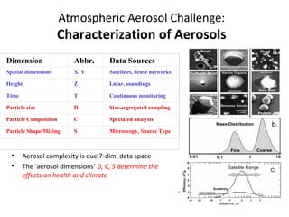
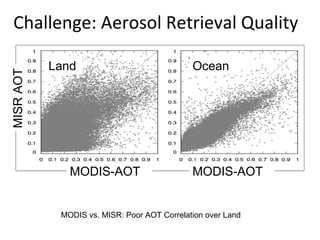
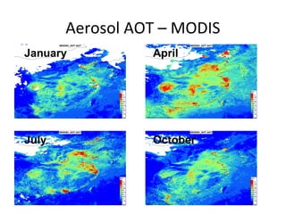
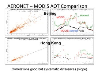
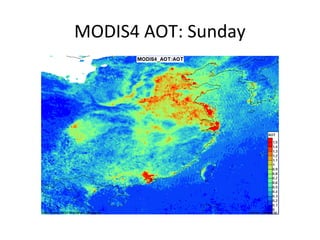
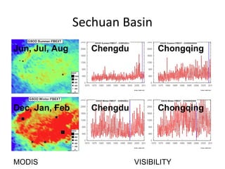
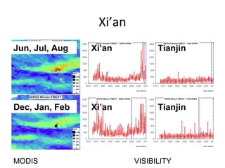
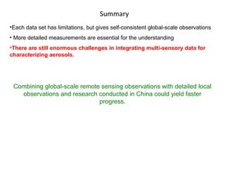
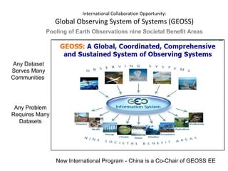
Spatial and Temporal Pattern of
Air Pollution over China Based on
Remote Sensing Observations
Rudolf B. Husar
With

Li Du, Erin Robinson
Washington University, St. Louis, MO, USA

Seminar at Fudan University,
May 28, 2010, Shanghai, China
Atmospheric Aerosol Challenge:

Characterization of Aerosols
Dimension

Abbr.

Data Sources

Spatial dimensions

X, Y

Satellites, dense networks

Height

Z

Lidar, soundings

Time

T

Continuous monitoring

Particle size

D

Size-segregated sampling

Particle Composition

C

Speciated analysis

Particle Shape/Mixing

S

Microscopy, Source Type

•
•

Aerosol complexity is due 7-dim. data space
The ‘aerosol dimensions’ D, C, S determine the
effects on health and climate
Aerosol concentration:
a (X, Y, Z, T, D, C, S)
Challenge: Vertical Distribution of Aerosols

Vertical Distribution:
• Layering
• Size Distr.
• Composition
•

Technical Challenge:
Characterization
PM characterization requires many different instruments and analysis tools.

• Each sensor/network covers only a fraction of the 7-Dim PM data space.

Satellite-Integral

Satellites, integrate over height,
size, composition, shape…
dimensions
These data need de-convolution of
the integral measures
Satellite Remote Sensing Since 1972
•
•
•

First satellite aerosol paper, Francis Parmenter, 1972
Qualitative surface-satellite aerosol relationship shown, 1976
Focus on regional ‘hazy blobs’, sulfate pollution

Regional Haze
Lyons W.A., Husar R.B. Mon. Weather Rev. 1976

SMS GOES June 30 1975
Satellites show the synoptic aerosol pattern
and provide rich spatial context …
e.g. pollution in valleys.

Jan 10, 2003, SeaWiFS

Dec 19, 2007, MODIS
The Perfect Dust Storm…
Apr. 7, 2001 SaeWiFS
Asian Dust Cloud over N. America
In Washington State, PM10
100 µg/m3
concentrations exceeded 100 µg/m3

Asian Dust

Hourly PM10

On April 27, the dust cloud arrived in
North America.
Regional average PM10
concentrations increased to 65 µg/m3
Satellite

(MODIS, OMI)

Sun Photometer
(Aeronet)

Visual Range
(WMO)
MISR AOT

Challenge: Aerosol Retrieval Quality
Land

MODIS-AOT

Ocean

MODIS-AOT

MODIS vs. MISR: Poor AOT Correlation over Land
Aerosol AOT – MODIS
January

April

July

October
AERONET – MODIS AOT Comparison
Beijing
MODIS

Aeronet

MODIS/Aeronet Ratio

Hong Kong

Correlations good but systematic differences (slope)
MODIS4 AOT: Thursday
MODIS4 AOT: Sunday
MODIS4 AOT: Thursday
MODIS4 AOT: Sunday
MODIS Fire Pixels
OMI Absorbing Aerosol Index
January

April

July

October
OMI CHCO Formaldehyde
January

April

July

October
Population
density

Emissions - NOx
Satellite Column Concentration: NO2, 2005

OMI Spectrometer Sensor
Satellite Column Concentration: NO2, 2009

OMI Spectrometer Sensor
OMI NO2 Day of Week: Thursday
OMI NO2 Day of Week: Sunday
Visibility is recorded at 7000+ stations hourly
Visual Range, Guilin 2010-05-23,24
Visual Range 16 km

Visual Range 9 km
Guilin
Surface Extinction Coefficient
Jun, Jul, Aug

Dec, Jan, Feb
Sechuan Basin
Jun, Jul, Aug

Chengdu

Chongqing

Dec, Jan, Feb

Chengdu

Chongqing

MODIS

VISIBILITY
Xi’an
Jun, Jul, Aug

Xi’an

Tianjin

Dec, Jan, Feb

Xi’an

Tianjin

MODIS

VISIBILITY
Summary
•Each data set has limitations, but gives self-consistent global-scale observations
• More detailed measurements are essential for the understanding
•There are still enormous challenges in integrating multi-sensory data for
characterizing aerosols.

Combining global-scale remote sensing observations with detailed local
observations and research conducted in China could yield faster
progress.
International Collaboration Opportunity:

Global Observing System of Systems (GEOSS)
Pooling of Earth Observations nine Societal Benefit Areas

Any Dataset
Serves Many
Communities

Any Problem
Requires Many
Datasets

New International Program - China is a Co-Chair of GEOSS EE

100528 satellite obs_china_husar

Editor's Notes

  • #6 The ATS was followed by the Synchronous Meteorological Satellite (SMS), the first series of geosynchronous weather satellites. SMS-1 was launched from Cape Canaveral, FL on May 17, 1974. It was the first operational satellite capable of detecting meteorological conditions from a fixed location