
Recommended
More Related Content
What's hot
What's hot (16)
Similar to Von thunnen
Similar to Von thunnen (20)
Recently uploaded
Recently uploaded (20)
Von thunnen
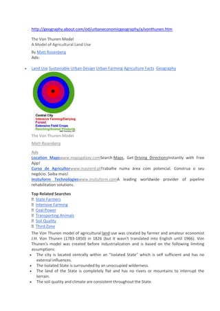
- 1. http://geography.about.com/od/urbaneconomicgeography/a/vonthunen.htm The Von Thunen Model A Model of Agricultural Land Use By Matt Rosenberg Ads: Land Use Sustainable Urban Design Urban Farming Agriculture Facts Geography The Von Thunen Model Matt Rosenberg Ads Location Mapswww.mapsgalaxy.comSearch Maps, Get Driving DirectionsInstantly with Free App! Curso de Agricultorwww.masterd.ptTrabalhe numa área com potencial. Construa o seu negócio. Saiba mais! Insituform Technologieswww.insituform.comA leading worldwide provider of pipeline rehabilitation solutions. Top Related Searches State Farmers Intensive Farming Coal Power Transporting Animals Soil Quality Third Zone The Von Thunen model of agricultural land use was created by farmer and amateur economist J.H. Von Thunen (1783-1850) in 1826 (but it wasn't translated into English until 1966). Von Thunen's model was created before industrialization and is based on the following limiting assumptions: The city is located centrally within an "Isolated State" which is self sufficient and has no external influences. The Isolated State is surrounded by an unoccupied wilderness. The land of the State is completely flat and has no rivers or mountains to interrupt the terrain. The soil quality and climate are consistent throughout the State.
- 2. Farmers in the Isolated State transport their own goods to market via oxcart (carro do bois) across land, directly to the central city. Therefore, there are no roads. Farmers act to maximize profits. In an Isolated State with the foregoing statements being true, Von Thunen hypothesized that a pattern of rings around the city would develop. There are four rings of agricultural activity surrounding the city. Dairying and intensive farming occur in the ring closest to the city. Since vegetables, fruit, milk and other dairy products must get to market quickly, they would be produced close to the city (remember, we didn't have refrigerated oxcarts!) Timber and firewood would be produced for fuel andbuilding materials in the second zone. Before industrialization (and coal power), wood was a very important fuel for heating and cooking. Wood is very heavy and difficult to transport so it is located as close to the city as possible. The third zone consists of extensive fields crops such as grains for bread. Since grains last longer than dairy products and are much lighter than fuel, reducing transport costs, they can be located further from the city. Ranching is located in the final ring surrounding the central city. Animals can be raised far from the city because they are self-transporting. Animals can walk to the central city for sale or for butchering. Beyond the fourth ring lies the unoccupied wilderness, which is too great a distance from the central city for any type of agricultural product. Even though the Von Thunen model was created in a time before factories, highways, and even railroads, it is still an important model in geography. The Von Thunen model is an excellent illustration of the balance between land cost and transportation costs. As one gets closer to a city, the price of land increases. The farmers of the Isolated State balance the cost of transportation, land, and profit and produce the most cost-effective product for market. Of course, in the real world, things don't happen as they would in a model. Suggested Reading Primate Cities Sectors of the Economy - Primary, Secondary, Tertiary, Quaternary, and Quinary Geography of Agriculture Related Articles Urban Geography Urban Geography Our Old Feuillage - Walt Whitman (1819-1892) History of Oklahoma City World War II - The Battle of the Bulge
- 3. Como referenciar este artigo: Johann von Thünen. In Infopédia [Em linha]. Porto: Porto Editora, 2003-2014. [Consult. 2014-07-28]. Disponível na www: <URL: http://www.infopedia.pt/$johann-von-thunen>. Economista alemão, nascido em 1783 e falecido em 1850, é autor da Teoria da Localização Agrícola, cujosprincípios expôs no livro publicado em 1826, O Estado Isolado. Baseando- se na observação das suaspropriedades, que ele próprio administrava, propôs um modelo p ara explicar a variação do uso do soloagrícola. Apesar das profundas alterações entretanto v erificadas na agricultura, a sua teoria continua arevelar- se pertinente na compreensão dos padrões de localização atualmente observados. OXCART -