NCIT civil Syllabus 2013-2014
•Download as DOCX, PDF•
0 likes•42 views

Engineering surveying

Recommended
More Related Content
What's hot
What's hot (20)
Similar to NCIT civil Syllabus 2013-2014
Similar to NCIT civil Syllabus 2013-2014 (20)
More from LAKSHITHA RAJAPAKSHA
More from LAKSHITHA RAJAPAKSHA (20)
Recently uploaded
Recently uploaded (20)
NCIT civil Syllabus 2013-2014
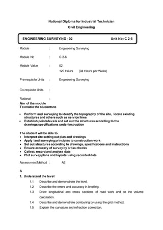
- 1. National Diploma for Industrial Technician Civil Engineering Module : Engineering Surveying Module No : C 2-6 Module Value : 02 120 Hours (04 Hours per Week) Pre-requisite Units : Engineering Surveying Co-requisite Units : Rational : Aim of the module To enable the students to Performland surveying to identify the topography of the site, locate existing structures and others such as service lines Establish points/levels and set out the structures according to the drawings/specifications under instruction The student will be able to Interpret site setting out plan and drawings Apply land surveying principles to construction work Set out structures according to drawings, specifications and instructions Ensure accuracy of survey by cross checks Collect, record and analyse data Plot surveyplans and layouts using recorded data Assessment Method : AE A 1. Understand the level 1.1 Describe and demonstrate the level. 1.2 Describe the errors and accuracy in levelling. 1.3 Draw longitudinal and cross sections of road work and do the volume calculation. 1.4 Describe and demonstrate contouring by using the grid method. 1.5 Explain the curvature and refraction correction. ENGINEERING SURVEYING - 02 ADMINISTRATION & CONTRACTUAL PROCEDURES Unit No: C 2-6 C
- 2. 1.6 Explain the tests and permanent adjustments of levels, B. 2. Understand the theodolite survey ( Traverse Survey) 2.1 Explain the parts of a theodolite measurement of horizontal and vertical angles 2.2 Demonstrate the skills of taking the accurate measurements and their booking, making the traverse sheet of a theodolite traverse. 2.3 Explain the Bow ditch’s method of adjustments for misclosure of the traverse. 2.4 Demonstrate the skills of plotting the plan. 2.5 Draw a plan view of a site by wing traverse surveying . 3. Understand the Tachometer 3.1 State the objectives and factors to be considered in tachometric survey. 3.2 Explain the measurements by using the fixed hair staid system of optical tachometer and by movable method. 3.3 State the field procedure of tachometry. 3.4 Demonstrate the skills of calculation readings. 3.5 State the use of tachometer and its accuracy. 3.6 Draw a contour plan view by using tachometry. C 4. Understand the volume measurements. 4.1 Explain the measurement of volume of irregular bodies by using cros-section, spot heights and contours 4.2 Calculate the volume from a plotted plan. 4.3 Calculate the volume by using a) End area formula. b) Prismodial area. 4.4 State the Prismodial corrections. D. 5. Understand a horizontal curve and vertical curve of road works. 5.1 State the requirements of a curve in the road work.
- 3. 5.2 Demonstrate the skills of calculating a suitable horizontal curve in the road works and set out according to the calculations after defined by giving two of the followings. a) Intersection angle, Deflection angle b) Tangent length, curve length, apex length, Degree of a curve. 5.3 State the sequence of setting out. 5.4 Demonstrate the skill of calculation and set out, a horizontal circular curve by using the method of deficetion angles using one theodolte and tape. 6. Understand a plane table surveying. 6.1 Describe plane table surveying and its application. 6.2 Explain the advantages of plane table surveying. 6.3 Explain the method of a) Radiation b) Intersection c) Resection 7. Electro magnetic distance measurement (EDM) 7.1 Measurement of distance using EDM instrument 7.2 Measurement of latitudes and departures using EDM 7.3 Use of total station Instrument in traverse survey and setting out. Use of EDM instruments: Total station instrument Introduction to Global Positioning System (GPS) Safe work practices related to surveying and levelling