NCIT civil Syllabus 2013-2014
•Download as DOCX, PDF•
0 likes•13 views

Engineering surveying

Recommended
More Related Content
What's hot
What's hot (19)
Similar to NCIT civil Syllabus 2013-2014
Similar to NCIT civil Syllabus 2013-2014 (20)
More from LAKSHITHA RAJAPAKSHA
More from LAKSHITHA RAJAPAKSHA (20)
Recently uploaded
Recently uploaded (20)
NCIT civil Syllabus 2013-2014
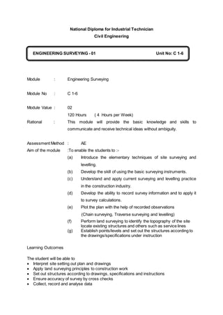
- 1. National Diploma for Industrial Technician Civil Engineering Module : Engineering Surveying Module No : C 1-6 Module Value : 02 120 Hours ( 4 Hours per Week) Rational : This module will provide the basic knowledge and skills to communicate and receive technical ideas without ambiguity. Assessment Method : AE Aim of the module :To enable the students to :- (a) Introduce the elementary techniques of site surveying and levelling. (b) Develop the skill of using the basic surveying instruments. (c) Understand and apply current surveying and levelling practice in the construction industry. (d) Develop the ability to record survey information and to apply it to survey calculations. (e) Plot the plan with the help of recorded observations (Chain surveying, Traverse surveying and levelling) (f) Perform land surveying to identify the topography of the site locate existing structures and others such as service lines (g) Establish points/levels and set out the structures according to the drawings/specifications under instruction Learning Outcomes The student will be able to Interpret site setting out plan and drawings Apply land surveying principles to construction work Set out structures according to drawings, specifications and instructions Ensure accuracy of survey by cross checks Collect, record and analyse data ENGINEERING SURVEYING - 01 Unit No: C 1-6 C
- 2. Plot survey plans and layouts using recorded data Suggested time allocation for section A 04 hours section B 30 hours section C 40 hours section D 12 hours section E 18 hours section F 16 hours A. BASIC PRINCIPLES 1 Know the basic surveying terms and principles. 1.1 Define the terms Surveying, levelling, datum surface, level surface, height, linear measurement, angular measurement, 1.2 Explain the terms Co - ordinates, offsets (perpendicular, oblique) 1.3 Explain the principles of surveying 1.4 Distinguish between the characteristics of different types of surveying. 1.5 Distinguish between the characteristics of different kind of surveying. B. LINEAR MEASUREMENT 2. Demonstrate the methods of direct linear measurement by carrying out simple field exercises and corrections. 2.1 Identify chain, tape, and band, arrows, compass to state their uses. 2.2 Demonstrate the uses of chain, tape and steel tape and compare the accuracy's 2.3 Measure sloping distances using a chain, tape and band both stepping and using a clinometers. 2.4 Explain the corrections applying to linear measurement (slope, reduction to m.s.l , pull correction temp correction sag correction etc) and sums relevant to those. 2.5 Describe and demonstrate the procedures of ranging of pokes. 2.6 Describe and demonstrate the methods when measuring with obstacles. 3. Demonstrate and understand the linear survey methods and plot the results obtained. 3.1 Measure offsets and ties by using optical square and tape.
- 3. 3.2 Demonstrate the methods of field booking and checking. 3.3 Identify the governing factors of chain survey. 3.4 Plot survey lines including all details. C LEVELLING. 4. Demonstrate the ability of using the level instrument and the associated calculation work. 4.1 Describe the traditional levelling methods and instruments including, Spirit, Dumpy Tilting & Automatic levels. 4.2 Use and check the accuracy of levelling instruments 4.3 Read the metric levelling staff. 4.4 Define levelling terms. 4.5 Record and calculate reduced levels by "rise and fall" and Collimation - Height methods and apply required checks. 4.6 Undertake different levelling practices such as, flying, grid, cross sectional and inverted staff. 4.7 Sate sources of induced and instrumental errors. 4.8 Described the two peg method and relevant sums. D . Compass traversing. 5. Know the use of compass to measure bearings. 5.1 Describe the basic structure of compass traversing 5.2 Explain the FB, BB, WCB, RB, meridian, magnetic declination local attraction. 5.3 Describe the procedures used to calculate WCB'S from internal angles. 5.4 Explain WCB, RB, Latitude and departures . 5.5 Described the Bowditch’s correction of corrective latitudes and departure. 5.6 Making the traverse sheet. E. AREAS 6. Understand the areas 6.1 Demonstrate the skills of measure a small area and plot them. 6.2 explain the methods of calculate of areas by using. a. Simpson’s rule b. Trapezoidal c. Average ordinate rule 6.3 Calculate the area from a plotted plan
- 4. F. SETTING OUT 7. Demonstrate a degree of competence in setting out procedure for a simple rectangular building. 7.1 Identify describe the equipments required including a site square. 7.2 Explain the setting out of a building including the possible constraints. 7.3 Describe and undertake the positioning of profiles and datum for a building. 7.4 Explain how profiles are used with a traveller to control excavation and foundation levels. 8 Undertake the setting out and levelling of drainage work. 8.1 Identify and describe the invert of a drain, a sight rail, and a traveller. 8.2 Calculate suitable length of traveller and reduced levels of sight rails from given drawings. 8.3 Establish sight rails for horizontal positions and depth control of a straight drain between manholes. 8.4 Checking the column verticality. 8.5 Controlling side slopes in embankments and cuttings.