Sector3 majiwada manpada
•
1 like•1,230 views

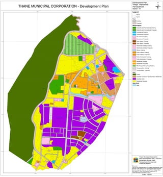
This document appears to be a development plan map for villages Majiwada and Panchpakhadi in Thane Municipal Corporation, Maharashtra, India. The map legend outlines various existing and proposed land use zones including residential, commercial, educational, open space, public utilities, transportation, industrial, forest zones and more. Key locations marked on the map include ACI, Tata Fison, Koras India industrial areas, and various government offices, schools, gardens, burial grounds and other infrastructure. Coordinates and a scale are provided, with a disclaimer that this is a GIS representation and not for legal use.

Recommended
More Related Content
What's hot
What's hot (20)
Similar to Sector3 majiwada manpada
Recently uploaded
Recently uploaded (20)
Sector3 majiwada manpada
- 1. 521 338 520 253 519 432 163 265 373 160 275 264 260 430 270 407 291 254 158 440 250 263 146 153 256 371 220 423 155 289 380 156 238 215 157 152 278 263 258 267 154 431 443 284 283 223 150 412 171 149 231 285 295 442 287 436 222 165 243 262 256 145 260 259 271 164 297 279 293 280 166 374 296 228 172 261 257 266 168 251 298 274 159 219 167 371 427 239 277 281 148 435 237 143 253 485 439 255 372 226 426 174 245 276 217 282 241 234 303/A 292 272 254 251 299 300/A 252 294/A 370 428 221 246 225 261 224 302 433 144 236 484 434 147 377 301 240 251/A 406 244 444/A 375 313 425 438/A 173 169 235 403 255 288 429 286 230 249 170 368 424 227 380/A 248 242 218 142 405 161 141 273 264 250/A 290 151 262 419 216 162 259 201 400 419 140 213 214 445/C 445/B 404 304/B 142 200 419 106 199 372 202 376 419 268 403 179 SC PG SC SC PG PG PO PG PG SC SC SC ESR GSR TMT MSEB Park Mhada Mhada Mhada Mhada Mhada Mhada Mhada Mhada Mhada Mhada Mhada Mhada Mhada Mhada Mhada MWSSB Garden Garden Garden M & WC M & WC E.S.I.S Parking Parking Dispensary Secondary Sc Fire Brigade Secondary Sc Secondary Sc Burial Ground Govt. Offices Police Station Cremation Ground Municipal Purpose Municipal Primary Sc Municipal Primary Sc Municipal Primary Sc Municipal Primary Sc Municipal Primary Sc Municipal Primary Sc Municipal Primary Sc Municipal Ward Office Rifle Range/Difence Area Dispensary And Maternity Home Dispensary And Maternity Home Dispensary And Maternity Home 3 1 3 5 2 3 5 3 5 1 1 2 3 3 1 2 9 8 1 2 1 1 1 2 1 1 2 2 1 1 1 1 3 8 M 33 M 40 M 40 M 16 M 10 M 18 M 10 M 25 M 20 M 20 M 30 M 20 M 40 M 25 M 15 M 40 M 15 M 16 M 15 M 15 M 30 M 15 M 15 M 15 M 15 M 15 M 15 M 15 M 30 M 20 M 20 M 20 M 20 M 20 M 20 M 20 M 20 M 20 M 15 M 20 M 18 M 20 M 10 M 10 M 20 M 10 M 10 M 10 M 10 M 10 M 12 M 10 M 12 M 12 M 10 M 18 M 12 M 40 M 12 M 14 M 24 M 16 M 20 M 20 M 30 M16 M 16 M 12 M 12 M 12 M 18 M 18 M 15 M 15 M 16 M 20 M 16 M 16 M 14 M18 M 18 M 40 M 18 M 18 M 15 M 16 M 16 M 80 M 14 M 16 M 18 M 12 M 20 M 20 M 30 M 20 M 20 M 40 M 20 M 20 M A C I Forest Tata Fison Koras India Pokhran Ind. Raptalds Brete Indian Smelting Wagale Industrial Estate A C I Forest Tata Fison Koras India Pokhran Ind. Raptalds Brete Indian Smelting Wagale Industrial Estate 72°57'30"E 72°57'30"E 72°57'0"E 72°57'0"E 72°56'30"E 72°56'30"E 19°13'0"N 19°13'0"N 19°12'30"N 19°12'30"N 19°12'0"N 19°12'0"N 19°11'30"N 19°11'30"N Ü Scale - 1:5,000 Thane Municipal Corporation, New Administrative Bldg., 2nd Floor Mahapalika Bhavan Marg, Pachpakhadi,Chandanwadi Thane(W)-400602 Disclaimer : This Is A GIS Representation Of Original Development Plans And Not To Be Used For Any Government/Legal Purposes. Any Discrepancies Detected, Kindly Refer Original Plans And Report To Town Development Department Of Thane Municipal Corporation, Thane Development Plan Village : Majiwada & THANE MUNICIPAL CORPORATION - Development Plan Sector : III Panchpakhadi Legend Parcel Sector Road Existing Proposed Reservation Assembly and Recreational, Existing Assembly and Recreational, Proposed Commercial, Existing Commercial, Proposed Educational, Existing Educational, Proposed Open Space, Existing Open Space, Proposed OtherPublic Utilities, Existing OtherPublic Utilities, Proposed Others, Existing Public Utilities, Existing Public Utilities, Proposed Public-Semipublic, Existing Public-Semipublic, Proposed Residential, Existing Residential, Proposed Rifle Range/Difence Area, Existing Transportation, Existing Transportation, Proposed Zone Forest Industrial Conversion of Industrial to Residential Industrial Zone Residential General Water Body Nalla