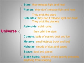
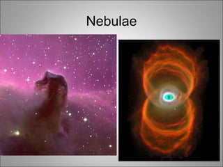
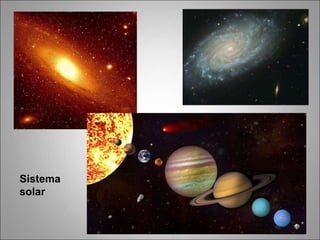
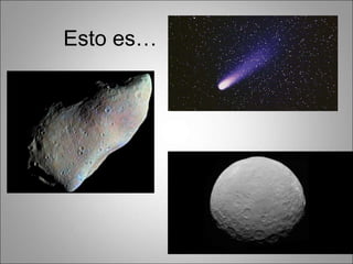
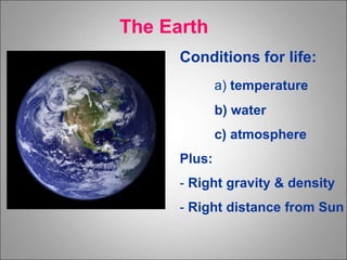
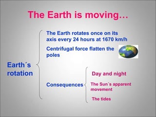
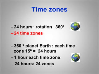
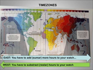
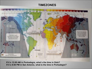
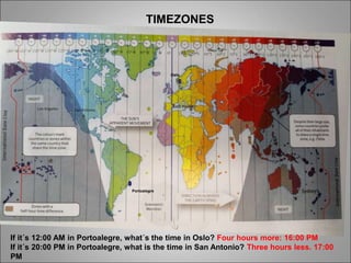
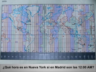
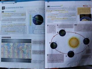
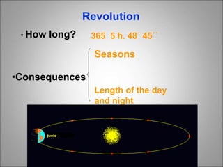
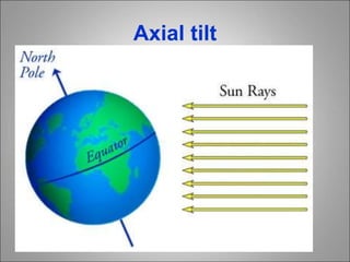
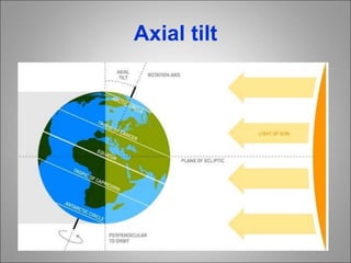
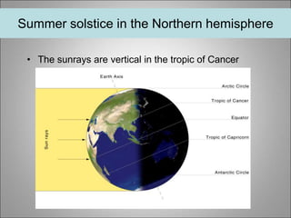
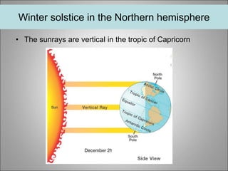
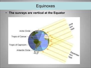
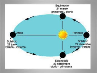
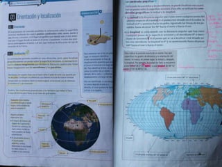
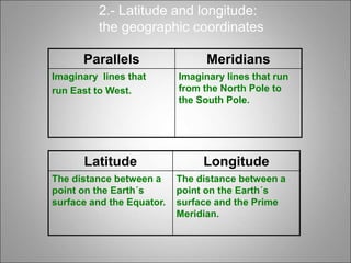
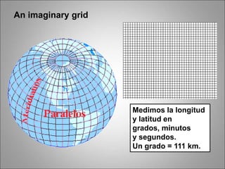
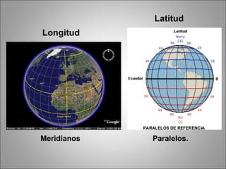
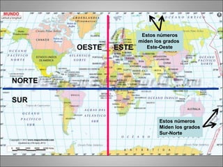
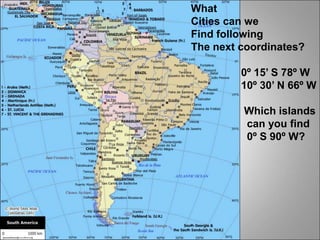
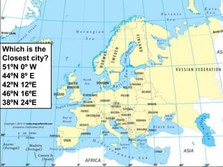
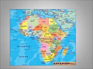
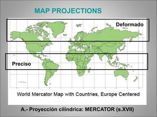
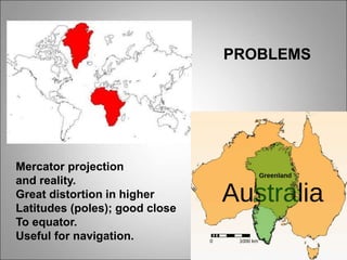
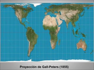
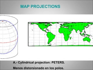
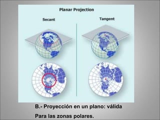
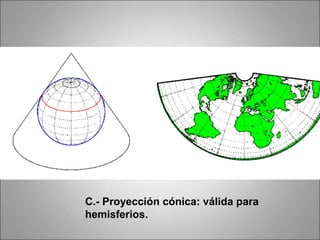
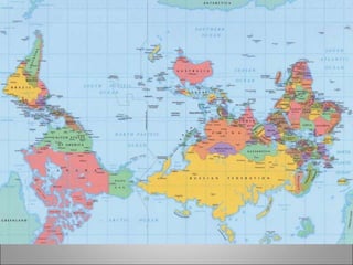
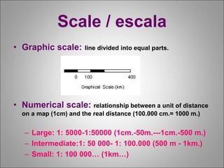
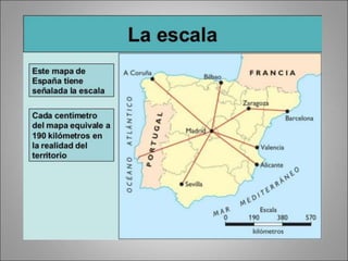
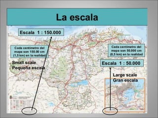
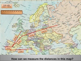
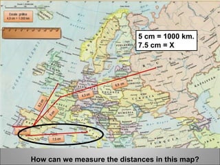
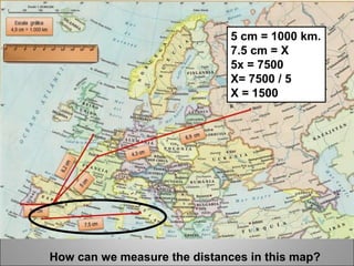
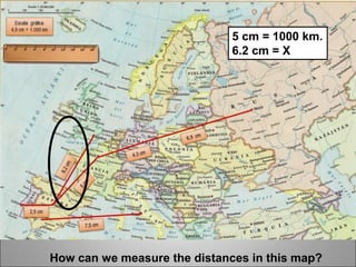
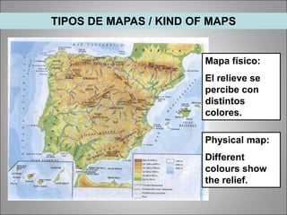
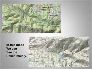
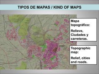
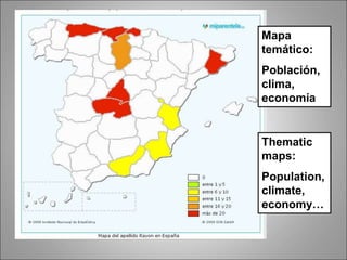
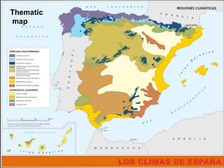
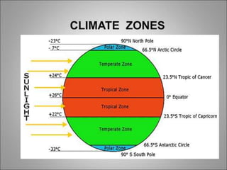
Universe
Stars: they release light and heat
Planets: they don´t release light and heat
They orbit the stars
Satellites: they don´t release light and heat
They orbit the planets
Asteroids: solid rocks.
they orbit the stars
Comets: balls of cosmic dust and ice
Meteors: small objects (rock and ice)
Nebulae: clouds of dust and gases
Space: dust and gases
Black holes: regions where gravity prevents
anything from scaping
Nebulae
Sistema
solar
Esto es…
Conditions for life:
a) temperature
b) water
c) atmosphere
Plus:
- Right gravity & density
- Right distance from Sun
The Earth
Earth´s
rotation
The Earth rotates once on its
axis every 24 hours at 1670 km/h
Centrifugal force flatten the
poles
Consequences
Day and night
The Sun´s apparent
movement
The Earth is moving…
The tides
Time zones
–24 hours: rotation 360º
–24 time zones
–360 º planet Earth : each time
zone 15º = 24 hours
–1 hour each time zone
24 hours: 24 zones
TIMEZONES
Portoalegre
Oslo
EAST: You have to add (sumar) more hours to your watch...
WEST: You have to substract (restar) hours to your watch
TIMEZONES
Portoalegre
Oslo
If it´s 12:00 AM in Portoalegre, what´s the time in Oslo?
If it´s 8:00 PM in San Antonio, what is the time in Portoalegre?
TIMEZONES
Portoalegre
Oslo
If it´s 12:00 AM in Portoalegre, what´s the time in Oslo? Four hours more: 16:00 PM
If it´s 20:00 PM in Portoalegre, what is the time in San Antonio? Three hours less. 17:00
PM
¿Qué hora es en Nueva York si en Madrid son las 12:00 AM?
Revolution
• How long? 365 5 h. 48´ 45´´
•Consequences
Seasons
Length of the day
and night
Axial tilt
Axial tilt
Midnight sun in Norway
21st June
(60 degrees North)
Summer solstice in the Northern hemisphere
• The sunrays are vertical in the tropic of Cancer
• The sunrays are vertical in the tropic of Capricorn
Winter solstice in the Northern hemisphere
Equinoxes
• The sunrays are vertical at the Equator
Latitude Longitude
The distance between a
point on the Earth´s
surface and the Equator.
The distance between a
point on the Earth´s
surface and the Prime
Meridian.
2.- Latitude and longitude:
the geographic coordinates
Parallels Meridians
Imaginary lines that
run East to West.
Imaginary lines that run
from the North Pole to
the South Pole.
An imaginary grid
Medimos la longitud
y latitud en
grados, minutos
y segundos.
Un grado = 111 km.
Longitud
Meridianos Paralelos.
Latitud
Estos números
miden los grados
Este-Oeste
Estos números
Miden los grados
Sur-Norte
OESTE ESTE
NORTE
SUR
What
Cities can we
Find following
The next coordinates?
0º 15’ S 78º W
10º 30’ N 66º W
Which islands
can you find
0º S 90º W?
Which is the
Closest city?
51ºN 0º W
44ºN 8º E
42ºN 12ºE
46ºN 16ºE
38ºN 24ºE
•What is cartography?
The study of maps
•Three characteristics of
maps
They are simple, reduced and use
colours and symbols
•Are map projections accurate?
No, they are distorted representations of
the Earth.
Visión medieval del mundo, siguiendo a Tolomeo (150 aC)
A.- Proyección cilíndrica: MERCATOR (s.XVII)
MAP PROJECTIONS
PROBLEMAS DE FIABILIDAD EN LA
REPRESENTACIÓN DE LA TIERRA
A.- Proyección cilíndrica: MERCATOR (s.XVII)
MAP PROJECTIONS
Deformado
Preciso
Mercator projection
and reality.
Great distortion in higher
Latitudes (poles); good close
To equator.
Useful for navigation.
PROBLEMS
Proyección de Gall-Peters (1855)
A.- Cylindrical projection: PETERS.
Menos distorsionado en los polos.
MAP PROJECTIONS
B.- Proyección en un plano: válida
Para las zonas polares.
C.- Proyección cónica: válida para
hemisferios.
Scale / escala
• Graphic scale: line divided into equal parts.
• Numerical scale: relationship between a unit of distance
on a map (1cm) and the real distance (100.000 cm.= 1000 m.)
– Large: 1: 5000-1:50000 (1cm.-50m.---1cm.-500 m.)
– Intermediate:1: 50 000- 1: 100.000 (500 m - 1km.)
– Small: 1: 100 000… (1km…)
Large scale
Gran escala
Small scale
Pequeña escala
How can we measure the distances in this map?
5 cm = 1000 km.
7.5 cm = X
How can we measure the distances in this map?
5 cm = 1000 km.
7.5 cm = X
5x = 7500
X= 7500 / 5
X = 1500
How can we measure the distances in this map?
5 cm = 1000 km.
6.2 cm = X
Mapa físico:
El relieve se
percibe con
distintos
colores.
TIPOS DE MAPAS / KIND OF MAPS
Physical map:
Different
colours show
the relief.
In this maps
We can
See the
Relief, mainly.
Mapa
topográfico:
Relieve,
Ciudades y
carreteras.
TIPOS DE MAPAS / KIND OF MAPS
Topographic
map:
Relief, cities
and roads.
Thematic
maps:
Population,
climate,
economy…
Mapa
temático:
Población,
clima,
economía
Thematic
map
Virtual map
Satellite photograph
Aerial photography
Remote sensing images.
Estas imágenes
suelen ofrecer
información que
escapa a la vista:
ultravioleta,
variaciones por la
gravedad, humedad
del terreno…
En esta imagen, se nos
explica la aridez del
suelo en Oriente
medio, usando
sensores que miden
temperatura.
¿Por qué tenemos distintas
zonas climáticas?
CLIMATE ZONESTropics Temperate zones Polar regions
High temperatures
throughout the year
Different number of
daylight hours
Low temperatures
throughout the year
Little differences
between seasons
Four seasons Summer and winter Low
temperatures
CLIMATE ZONES
Night in the winter: Norway
Tema 1 1 eso 2019

Tema 1 1 eso 2019