
Recommended
More Related Content
Similar to Geography of Africa
Similar to Geography of Africa (20)
More from JulieBinderMaitra1
Recently uploaded
Recently uploaded (20)
Geography of Africa
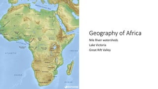
- 1. Geography of Africa Nile River watersheds Lake Victoria Great Rift Valley
- 2. UN Region Name Country ISO 3166 alpha-3 codes Northern Africa Egypt EGY Sudan SDN Eastern Africa Burundi BDI Eritrea ERI Ethiopia ETH Kenya KEN Rwanda RWA South Sudan SSD Uganda UGA Tanzania TZA Middle Africa Democratic Republic of the Congo COD Our area of interest Nile River Basin countries
- 3. Nile River Watersheds • At 6853 km (4,258 miles), the Nile River is commonly regarded as the longest river in the world (although some sources cite the Amazon River as the longest). • The Nile has two major tributaries: White Nile and Blue Nile. • The White Nile is the headwaters and primary stream of the Nile. It rises near Lake Victoria. It flows north through Uganda, Sudan, and South Sudan. • The Blue Nile begins at Lake Tana in Ethiopia and flows into Sudan from the southeast. • The White Nile and Blue Nile meet north of Khartoum. • The Nile then flows north through the Sudanese desert to Egypt, ends in a large delta, and flows into the Mediterranean Sea.
- 4. Lake Victoria • Lake Victoria is considered the source of the Nile, although the most distant source might be in Burundi or Rwanda. • With a surface area of approximately 59,947 square km (23,146 sq mi), it is Africa's largest lake, the world's largest tropical lake, and the world's second largest fresh water lake, after Lake Superior in North America. • Its surface elevation is 1,135 m (3,724 ft). • Kenya, Uganda, and Tanzania border Lake Victoria. • Burundi and Rwanda are also basin countries.
- 5. Great Rift Valley • The term Great Rift Valley most often refers to the valley of the East African Rift, which is the divergent plate boundary that is splitting the African Plate into two separate plates. • Geologists generally call these incipient plates the Nubian Plate and the Somali Plate. • The Afar Triangle is a junction where three plates are pulling away from one another: the Arabian Plate, the Nubian Plate, and the Somali Plate. • The Great Rift Valley has two branches, the Western Rift Valley and the Eastern Rift Valley. • Lake Victoria lies between the two branches. • Some of Africa’s highest mountains in Africa border the Western Rift, which also contains some of the deepest lakes in the world (up to 1,470 meters, or 4,820 ft).
- 6. Great Rift Valley. (2018, November 06). Retrieved November 19, 2018, from https://en.wikipedia.org/wiki/Great_Rift_Valley Lake Victoria. (2018, November 13). Retrieved November 19, 2018, from https://en.wikipedia.org/wiki/Lake_Victoria Nile. (2018, November 15). Retrieved November 19, 2018, from https://en.wikipedia.org/wiki/Nile Textual sources
- 7. Data sources 10m-cultural-vectors | Natural Earth. (n.d.). Retrieved November 19, 2018, from https://www.naturalearthdata.com/downloads/10m-cultural-vectors/ open data 10m-physical-vectors | Natural Earth. (n.d.). Retrieved November 19, 2018, from https://www.naturalearthdata.com/downloads/10m-physical-vectors/ open data 10m-raster-data | Natural Earth. (n.d.). Retrieved November 19, 2018, from https://www.naturalearthdata.com/downloads/10m-raster-data/ open data Google Earth/KML Files. (n.d.). Retrieved November 19, 2018, from https://earthquake.usgs.gov/learn/kml.php Tectonic plate boundaries Harvard WorldMap. (n.d.). Retrieved November 19, 2018, from http://worldmap.harvard.edu/data/geonode:great_rift_valley_ofb Great Rift Valley Maps and spatial data. (n.d.). Retrieved November 19, 2018, from http://www.fao.org/nr/water/aquastat/maps/index.stm Watersheds UNSD - Methodology. (n.d.). Retrieved November 20, 2018, from https://unstats.un.org/unsd/methodology/m49/ geographical regions used by the UN Statistics Division and alpha-3 country codes World Cities Database. (n.d.). Retrieved November 19, 2018, from https://simplemaps.com/data/world-cities World Cities
- 8. Data processing Data was processed in QGIS, a free and open Geographic Information System software program. Maps created through QGIS were saved to images, which were subsequently inserted into a PowerPoint presentation.
- 9. Vocabulary Afar Triangle, African Plate, Arabian Plate, Blue Nile, Burundi, Democratic Republic of the Congo, East African Rift, Eastern Rift Valley, Egypt, Eritrea, Ethiopia, Geographic Information System, GIS, Great Rift Valley, Kenya, Khartoum, Lake Tana, Lake Victoria, Mediterranean Sea, middle school, Nile River, Nubian Plate, Open data, Open source, PowerPoint, QGIS, Radiant Earth, Republic of the Sudan, Rwanda, Somali Plate, South Sudan, Tanzania, Uganda, Western Rift Valley, White Nile
- 10. Test your knowledge Go to https://quizlet.com/342747052/geography-of-africa-diagram/
Editor's Notes
- The UN has grouped countries in Africa in 5 subregions Our interests are the subregions and countries in the Nile River Basin