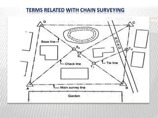
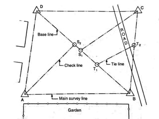
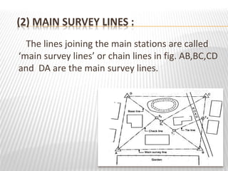
Elements Of Civil Engineering
Subject Code: (2110004)
Topic : Chain Survey
Division: K
Group Members: 1).Patel Umang A. (Roll No.-23)
2).Patel Vishal S. (Roll No.-26)
3).Rana Devang H. (Roll No.-40)
4).Rathod Utam M. (Roll No.-42)
Guided By :- Prof. Neel K. Shah
 WHAT IS CHAIN SURVEING ?
• Chain surveying is the type of surveying in
which only linear measurements are taken in
the field.
• This type of surveying is done for surveys of
small extent to describe the boundaries of plot
of land to locate the existing features on them.
• It is the method of surveying in which the area
is divided into network of triangles and the
sides of the various triangles are measured
directly in the field with a chain or a tape and
no angular measurements are taken.
PRINCIPAL OF CHAIN SURVEYING
• The principal of chain surveying is to divide the
area into a number of triangles of suitable sides.
• As a triangles is the only simple plane of
geometrical figure which can be plotted from the
lengths of the three sides even if the angels are
not known.
• A network of triangles (triangulation) is
preferred to in chain surveying .
• If the area to be surveyed is triangular in shape
and if the lengths and sequence of its three
sides are recorded the plane of area can be easily
drawn.
TERMS RELATED WITH CHAIN SURVEYING
(1) SURVEY STATIONS
Survey stations are the points at the beginning
and at the end of the chain line. They may also
occur at any convenient position on the chain
line. Such stations may be :
(a) Main stations
(b) Subsidiary stations
(c) Tie stations
(a) Main stations :
Stations taken along the boundary of an area
as controlling points known as ‘main stations’.
The lines joining the main stations are called
‘main survey lines’. The main survey lines should
be cover the whole area to be surveyed. The
main stations are denoted by ‘ ’ with letters
A,B,C,D, etc.
(B) Subsidiary stations :
Stations which are on the main survey lines or
any other survey lines are known as ‘Subsidiary
stations’. These stations are taken to run
subsidiary lines for dividing the area into
triangles , for checking the accuracy of triangles
and for locating interior details.
these stations are denoted by ‘ ‘ with letters S1,
S2, S3, etc.
(c) Tie stations :
These are also subsidiary stations taken on the
main survey lines. Lines joining the tie stations
are known as ‘tie lines’.
Tie lines are taken to locate interior details. The
stations are denoted by ‘ ’ with letters T1 , T2 ,
T3 , etc.
(2) MAIN SURVEY LINES :
The lines joining the main stations are called
‘main survey lines’ or chain lines in fig. AB,BC,CD
and DA are the main survey lines.
(3) BASE LINE :
The line on which the framework of the survey is
built is known as the ‘base line’ . It is the most
important line of the survey . Generally , the
longest of the main survey line is considered as
the base line. This line should be measured very
carefully and accurately. In fig. BD is the base
line.
(4) CHECK LINE :
The line joining the apex point of a triangle to
some fixed points on its base is known as the
‘check line’. It is taken to check the accuracy of
the triangle . Sometimes this line is helps to
locate interior details . In fig. CS1 , AS2 are the
check lines.
(5) TIE – LINE :
A line joining tie stations is termed as a tie line. It
is run to take the interior details which are far
away from the main lines and also to avoid long
offsets. It can also serve as check line. In Fig.
T1 T2 is the tie line.
PROCEDURE
(1) Fix station A and B at some distance by fixing
wooden peg to determine horizontal distance
between them.
(2) Position of station A and B is fixed by
measuring their position from at least three
permanent objects and location sketch of
station A and B are drawn.
(3) The follower holds one handle of the chain in
contact with peg at station A.
(4) The leader takes the other handle of the chain,
arrows and ranging rod & walks in the forward
direction dragging chain with him.
(5) After the chain is stretched completely
along the line the follower steps on one
side of the line with the ranging rod
touching the handle.
(6) The follower directs to leader to stand exactly
in the line. The leader puts a scratch at the
position & inserts an arrow. He then moves
forward with the chain handle with the
remaining arrows and ranging rod till the
follower reaches the next arrow point.
Chain surveying.1

Chain surveying.1

  • 1.
    Elements Of CivilEngineering Subject Code: (2110004) Topic : Chain Survey Division: K
  • 2.
    Group Members: 1).PatelUmang A. (Roll No.-23) 2).Patel Vishal S. (Roll No.-26) 3).Rana Devang H. (Roll No.-40) 4).Rathod Utam M. (Roll No.-42) Guided By :- Prof. Neel K. Shah
  • 3.
     WHAT ISCHAIN SURVEING ? • Chain surveying is the type of surveying in which only linear measurements are taken in the field. • This type of surveying is done for surveys of small extent to describe the boundaries of plot of land to locate the existing features on them.
  • 4.
    • It isthe method of surveying in which the area is divided into network of triangles and the sides of the various triangles are measured directly in the field with a chain or a tape and no angular measurements are taken.
  • 7.
    PRINCIPAL OF CHAINSURVEYING • The principal of chain surveying is to divide the area into a number of triangles of suitable sides. • As a triangles is the only simple plane of geometrical figure which can be plotted from the lengths of the three sides even if the angels are not known.
  • 8.
    • A networkof triangles (triangulation) is preferred to in chain surveying . • If the area to be surveyed is triangular in shape and if the lengths and sequence of its three sides are recorded the plane of area can be easily drawn.
  • 9.
    TERMS RELATED WITHCHAIN SURVEYING
  • 10.
    (1) SURVEY STATIONS Surveystations are the points at the beginning and at the end of the chain line. They may also occur at any convenient position on the chain line. Such stations may be : (a) Main stations (b) Subsidiary stations (c) Tie stations
  • 11.
    (a) Main stations: Stations taken along the boundary of an area as controlling points known as ‘main stations’. The lines joining the main stations are called ‘main survey lines’. The main survey lines should be cover the whole area to be surveyed. The main stations are denoted by ‘ ’ with letters A,B,C,D, etc.
  • 13.
    (B) Subsidiary stations: Stations which are on the main survey lines or any other survey lines are known as ‘Subsidiary stations’. These stations are taken to run subsidiary lines for dividing the area into triangles , for checking the accuracy of triangles and for locating interior details. these stations are denoted by ‘ ‘ with letters S1, S2, S3, etc.
  • 14.
    (c) Tie stations: These are also subsidiary stations taken on the main survey lines. Lines joining the tie stations are known as ‘tie lines’. Tie lines are taken to locate interior details. The stations are denoted by ‘ ’ with letters T1 , T2 , T3 , etc.
  • 15.
    (2) MAIN SURVEYLINES : The lines joining the main stations are called ‘main survey lines’ or chain lines in fig. AB,BC,CD and DA are the main survey lines.
  • 16.
    (3) BASE LINE: The line on which the framework of the survey is built is known as the ‘base line’ . It is the most important line of the survey . Generally , the longest of the main survey line is considered as the base line. This line should be measured very carefully and accurately. In fig. BD is the base line.
  • 18.
    (4) CHECK LINE: The line joining the apex point of a triangle to some fixed points on its base is known as the ‘check line’. It is taken to check the accuracy of the triangle . Sometimes this line is helps to locate interior details . In fig. CS1 , AS2 are the check lines.
  • 19.
    (5) TIE –LINE : A line joining tie stations is termed as a tie line. It is run to take the interior details which are far away from the main lines and also to avoid long offsets. It can also serve as check line. In Fig. T1 T2 is the tie line.
  • 20.
  • 21.
    (1) Fix stationA and B at some distance by fixing wooden peg to determine horizontal distance between them. (2) Position of station A and B is fixed by measuring their position from at least three permanent objects and location sketch of station A and B are drawn.
  • 22.
    (3) The followerholds one handle of the chain in contact with peg at station A. (4) The leader takes the other handle of the chain, arrows and ranging rod & walks in the forward direction dragging chain with him.
  • 23.
    (5) After thechain is stretched completely along the line the follower steps on one side of the line with the ranging rod touching the handle.
  • 24.
    (6) The followerdirects to leader to stand exactly in the line. The leader puts a scratch at the position & inserts an arrow. He then moves forward with the chain handle with the remaining arrows and ranging rod till the follower reaches the next arrow point.