
Recommended
Recommended
More Related Content
What's hot
What's hot (16)
Similar to Data sheet el manto blanco
Similar to Data sheet el manto blanco (20)
Recently uploaded
Recently uploaded (20)
Data sheet el manto blanco
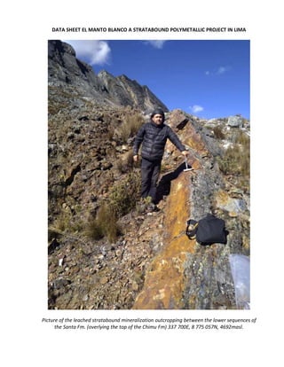
- 1. DATA SHEET EL MANTO BLANCO A STRATABOUND POLYMETALLIC PROJECT IN LIMA Picture of the leached stratabound mineralization outcropping between the lower sequences of the Santa Fm. (overlying the top of the Chimu Fm) 337 700E, 8 775 057N, 4692masl.
- 2. The lower Cretaceous sequence, represented by the Fm. Chimu (quartzite) thrusts over the Fm. Jumasha (limestone) in turn it thrusts over the Tertiary Yantac Group File No: 010052418, 010061718, 010061818. Property name: El Manto Blanco, El Manto Blanco E, El Manto Blanco SE. Submitted by the current owner: Christian VARGAS Address: San Borja Sur 777 Dpto 402, Lima 41, PERU. Phone: +511 2264271 Cel: +511 989204014 Email: chrisvar8@hotmail.com Location country: PERU Region/Province/District: Lima, Junín / Huaral, Yauli / Atavillos Alto, Santa Bárbara de Carhuacayán. Map Sheet: 23-J Canta Scale: 1:100 000 System: WGS84 Latitude/UTM: 8 754 000 Longitude/UTM: 337 000 Zone: 18S Accessibility: Segment Km Surface Time Condition Lima - Canta 105 Asphalt 2h good Canta – Cross road Yantac 60 Affirmed 1h good Cross Road Yantac - Entrance 6 Affirmed 0.2h regular Accessibility table from Lima to the Project
- 3. Accessibility map of the Project from Lima Description of land situation: Picture taken from the East, the landscape of Yantac is dominated by the cliff of limestone.
- 4. The Project extends over the drainage divide of the Cordillera Occidental, the River Chancay (Pacific Basin) begins on the western slope, and the Chinchaycocha Lake Drainage (Amazonian Basin) begins on the eastern slope. The main mountains presents are from the north to the south: Cerro Parcash, Cerro León Pata, and the Nevado Alcay. Several glacial lakes are also present between the mountains, at the bottom of the U shape valleys, like: Culacancha, Parcash, Yanauyac, Lacsacocha, Encantada, Quisha, Lisicocha. The project is located near the junction of the roads going from Lima and Huaral to Cerro de Pasco. At 4,600 metres above sea level, El Manto Blanco has an (E) Alpine tundra climate with the average temperature of the warmest month below the 10 °C threshold that would allow for tree growth, giving the countryside its barren appearance. El Manto Blanco has humid, damp and cloudy summers with frequent rainfall and dry, sunny winters with cool to cold temperatures throughout the year. Snowfall occurs sporadically during any season and is most commonly around dawn. The average annual temperature in Yantac is 5.5 °C and the average annual rainfall is 999 mm. Satellite image of the Fm Chimu´s footwall, hosts of the stratabound and vein mineralization
- 5. General Geology: The Miocene Peruvian Central Polymetallic Belt contains numerous styles of mineralization many of which have been mined since at least Spanish colonial time, including high-grade polymetallic (precious and base metal) vein systems (Huampar, Coricancha, Casapalca, Morococha), polymetallic carbonate replacement (Huanzala, Uchuchacua, Izcaycruz, Santander, Alpamarca, El Manto Blanco) and skarn deposits (Antamina, Magistral, Poderosa, Felicidad, Casapalca, Morococha) and copper porphyries (Toromocho). Regional geological map and cross section of the Peruvian Central Polymetallic Belt The belt is centered east of the Mesozoic and early Paleocene Coastal batholiths and lies on mature continental crust that has undergone multiple episodes of compressive deformation from at least middle Palaeozoic to latest Neogene time. Mineral deposits are predominantly hosted by shelf carbonates and other sedimentary rocks of Late Triassic, Jurassic, and Cretaceous age and by volcanic and intrusive rocks mainly of Neogene age.
- 6. Base metal and precious metal mineralization was intimately associated in time and space with the eruption of calc-alkali volcanic rocks of intermediate composition and the emplacement of mineralogically and geochemically similar dykes and stocks. Local Geology In a district scale El Manto Blanco is located in the Western rim of a giant volcanic caldera (Bombón High Plateau) formed during the Miocene period. The thrust of the Occidental Cordillera has preserved several fertile porphyry epithermal systems rich in Cu, Pb, Zn, Au, and Ag. The basement that host the volcanic rim is represented by the Goyllarisquizga Group, a sequence of thick sandstone, shale, and limestone. Overlies the carbonated sequence of the Machay Group and at the top the Limestone package of the Jumasha Group. This N30W general strike of the mineralization is controlled by a regional reverse fault system dipping to the west. Preliminary geological Map of the El Manto Blanco, Source INGEMMET
- 7. El Manto Blanco project presents intrusion-related, carbonate-hosted, distal ‘passive’ replacement deposits, or carbon replacement deposits (CRDs). Controls on mineralization vary, however, with the majority of mineralization displaying very strong structural and lithological controls. Satellite image of the 50m width polymetallic mantos hosted by the Santa Formation El Manto Blanco CRDs, in common with those in other districts, displays a strong mineralogical and metallic zonation: a ‘classic’ lateral or vertical zonation (from distal to proximal) would be Mn » Ag » Pb+Ag » Zn » Cu+Au. El Manto Blanco is underlain by an approximately 2,600-metre thick package of Cretaceous clastic and carbonate sedimentary rocks known as the Goyllarisquizga Group, within which an approximately 1,000-metre thick sequence of massive limestones and limestone-shales of the Jumasha and Chulec Formations (Machay Group) are the principal hosts identified to date. Pre-mineralization diabase dykes and sills are locally present within the section. The entire sequence is tightly folded into a series of orogen-parallel, northwest-trending anticlines and synclines. The lower, predominantly clastic part of the section (Chimu Formation) has been thrust over the Tertiary volcanoclastic red beds (Yantac Group) and the andesitic Tertiary volcanics and lacustrine sediments of the Calipuy Group. The carbonate-rich upper portion (the favorable host rocks) out crops along the regional northwest-trending Fault Zone. Unconformably overlying the tightly folded Oyon formations and the Cretaceous sediments that are moderately folded and faulted. Syn-mineralization intrusive activity, considered to be the heat and fluid sources that produced base metal mineralization, has not been recognized on the property to date.
- 8. This absence is empirically considered indicative of a relatively large CRD system, and such bodies are inferred to be present at depth (>400 meters) on the property. Stratigraphic column of the El Manto Blanco Project, the right column shows the frequency of economic CRD mineralization hosted in the units The alteration transits from propylitic, hornfels to phyllic and argillic, the notorious advanced argillic alteration outcropping is supergenic, and is mainly related to the oxidation of the sulfide ores. The strata bound mineralization has been exceptionally developed in several mantos in the three identified groups.
- 9. Satellite image shows the alternating polymetallic Mantos hosted in the Carbonated Sequences of the Early Cretaceous Picture looking to the southeast, shows the same alternating polymetallic Mantos hosted in the Early Cretaceous Carbonated Sequences The size of the mantos reach hundreds meters in the northwest trending and up to 250m width. The average historic grade of these mantos is near to 10% Zn_Eq.
- 10. Satellite image shows the supergenic alteration of the alternating polymetallic Mantos (200m width) host in the Santa Fm. (Goyllarisquizga Group) a black shale, sandstone and carbon sequence from the early Cretaceous Commodity (s): Pb, Zn, Ag (Cu, Au, V) Deposit Type: Concealed Porphyry Cu Au (Mo), Polymetallic Skarn, CRD Pb Zn Ag, Intermediate sulfidation veins and breccias. Size Potential: > 20Mt@10% Zn_Eq ESTIMATION OF RESOURCES Length Width Depth Tonnage Grade Zn Grade Pb Grade Ag Value x t Unit m m m m3 x t/m3 % % Oz US$ Proven Reserve 500 200 200 20 000 000 7 4 2.0 285 Indicated Resource 1 000 250 500 125 000 000 5 2 1.5 188 Inferred Resource 3 000 250 1000 750 000 000 3 1 1 110 TOTAL 895 000 000 Preliminary Estimation of Resources Box of the El Manto Blanco Mine Cost-Benefit Analysis per Tonnage: Without a fully owned metallurgical plant, the recovery is estimated to 65%, and with a fully owned metallurgical plant, (more than 1000t x day of processing capacity) the recovery is estimated to 85%.
- 11. ESTIMATION OF COST OPEN PIT TRANSPORT PLANT TOLLING TRANSPORT TOTAL Unit US$ US$ US$ US$ US$ US$ WITHOUT PLANT 10 10 40 40 10 110 WITH PLANT 10 5 20 20 10 65 Cost table per tonnage PRE-TAX PROFIT MARGIN Value A Value B Value C PROFIT A PROFIT B PROFIT C Unit US$ US$ US$ US$ US$ US$ WITHOUT PLANT 185 122 72 75 12 -38 WITH PLANT 242 160 94 177 95 29 Benefit table per tonnage Updated works (by others including current owner/seller): Geological visit, ASTER analysis, ancient adits, and mining roads. Deal terms: Open Remarks: Huge Potential, excellent accessibility, several polymetallic mines currently working. Comment: El Manto Blanco has enough field evidence, especially by the extension of the brecciated outcroppings than its potential is important, the neighboring polymetallic mines: Santander and Alpamarca (7km to the north and 5km to the east respectively) are witnessing of the economic validity of the district. Recommendations: Please feel free to visit and measure the size of the exposed system ready to be mined by the open pit method.