[IJET-V1I3P1] Authors :Sayli Nikumbh,Suchal Gujarathi,Shubham Pawar,S.P.Pingat
•
0 likes•149 views

The goal of this project is to provide a location-based alarm system through which users can broadcast their last known position in emergency situations. The system will be able to send an SMS or an e-mail containing the user’s location coordinates to the already registered mobile numbers using GCM service. The location information is obtained using GPS technology and real-time location is shown on the receiver’s application using Google Maps API. In situations where GPS is not available, the system tracks location using LBS technology .Keywords: GPS,GCM,LBS Android.
![International Journal of Engineering and Techniques - Volume 1 Issue3, May – June 2015
ISSN: 2395-1303 http://www.ijetjournal.org Page 2
Fig 2.GCM architecture overview
III. TECHNOLOGIES USED
A) GPS
In the past few years, smart mobile devices
have grown cheaper. The GPS sensor present
in these devices provides a huge scope for
location based services. A GPS receiver uses
signals transmitted by GPS satellites to
calculate the exact location in terms of the
latitude, longitude and altitude. GPS devices
retrieve GPS signals from three or more
satellites in the user’s vicinity. With the help
of these signals, the GPS unit calculates data
which includes three-dimensional position,
velocity and time information. Due to the
incorporation of GPS devices in Android and
other smart phones, it is easier to provide such
location based services. Android SDK
provides API for such location based services
since one of the first versions Android 1.5. The
Social Complain Mobile App uses this
technology to find the location of the
complaint.
B) GOOGLE MAPS API
Google Maps is a web mapping
service application provided by Google Inc[8].
It provides street maps and satellite imagery of
all locations across the globe. The Google
maps Application Programming Interface
(API) allows developers to embed the maps
into their applications. This API is used in
GPSCRS for detecting the administrative area
of the complaint and plotting all the registered
complaints on the map.
C) LOCATION BASED SERVICES
Location-based services (LBS) are a general
class of computer program-level services that
use location data to control features. As such
LBS is an information service and has a
number of uses in social networking today as
an entertainment service, which is accessible
with mobile devices through the mobile
network and which uses information on the
geographical position of the mobile device.
This has become more and more important
with the expansion of the smart phone and
tablet markets as well.
LBS are used in a variety of contexts,
such as health, indoor object
search, entertainment, work, personal life,
etc.LBS include services to identify a
location of a person or object, such as
discovering the nearest banking cash machine
(a.k.a. ATM) or the whereabouts of a friend or
employee. LBS include parcel tracking
and vehicle tracking services. LBS can
include mobile commerce when taking the
form of coupons or advertising directed at
customers based on their current location.
They include personalized weather services
and even location-based games
Fig 3.Location Based Service Overview.](data:image/gif;base64,R0lGODlhAQABAIAAAAAAAP///yH5BAEAAAAALAAAAAABAAEAAAIBRAA7)
Recommended
Recommended
More Related Content
What's hot
What's hot (20)
Viewers also liked
Viewers also liked (11)
Similar to [IJET-V1I3P1] Authors :Sayli Nikumbh,Suchal Gujarathi,Shubham Pawar,S.P.Pingat
Similar to [IJET-V1I3P1] Authors :Sayli Nikumbh,Suchal Gujarathi,Shubham Pawar,S.P.Pingat (20)
More from IJET - International Journal of Engineering and Techniques
More from IJET - International Journal of Engineering and Techniques (20)
Recently uploaded
Recently uploaded (20)
[IJET-V1I3P1] Authors :Sayli Nikumbh,Suchal Gujarathi,Shubham Pawar,S.P.Pingat
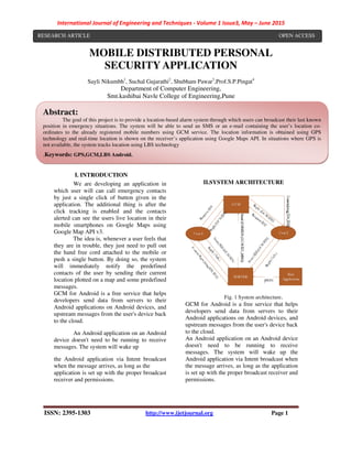
- 1. International Journal of Engineering and Techniques - Volume 1 Issue3, May – June 2015 ISSN: 2395-1303 http://www.ijetjournal.org Page 1 MOBILE DISTRIBUTED PERSONAL SECURITY APPLICATION Sayli Nikumbh1 , Suchal Gujarathi2 , Shubham Pawar3 ,Prof.S.P.Pingat4 Department of Computer Engineering, Smt.kashibai Navle College of Engineering,Pune I. INTRODUCTION We are developing an application in which user will can call emergency contacts by just a single click of button given in the application. The additional thing is after the click tracking is enabled and the contacts alerted can see the users live location in their mobile smartphones on Google Maps using Google Map API v3. The idea is, whenever a user feels that they are in trouble, they just need to pull out the hand free cord attached to the mobile or push a single button. By doing so, the system will immediately notify the predefined contacts of the user by sending their current location plotted on a map and some predefined messages. GCM for Android is a free service that helps developers send data from servers to their Android applications on Android devices, and upstream messages from the user's device back to the cloud. An Android application on an Android device doesn't need to be running to receive messages. The system will wake up the Android application via Intent broadcast when the message arrives, as long as the application is set up with the proper broadcast receiver and permissions. II.SYSTEM ARCHITECTURE Fig. 1 System architecture. GCM for Android is a free service that helps developers send data from servers to their Android applications on Android devices, and upstream messages from the user's device back to the cloud. An Android application on an Android device doesn't need to be running to receive messages. The system will wake up the Android application via Intent broadcast when the message arrives, as long as the application is set up with the proper broadcast receiver and permissions. Abstract: The goal of this project is to provide a location-based alarm system through which users can broadcast their last known position in emergency situations. The system will be able to send an SMS or an e-mail containing the user’s location co- ordinates to the already registered mobile numbers using GCM service. The location information is obtained using GPS technology and real-time location is shown on the receiver’s application using Google Maps API. In situations where GPS is not available, the system tracks location using LBS technology .Keywords: GPS,GCM,LBS Android. RESEARCH ARTICLE OPEN ACCESS
- 2. International Journal of Engineering and Techniques - Volume 1 Issue3, May – June 2015 ISSN: 2395-1303 http://www.ijetjournal.org Page 2 Fig 2.GCM architecture overview III. TECHNOLOGIES USED A) GPS In the past few years, smart mobile devices have grown cheaper. The GPS sensor present in these devices provides a huge scope for location based services. A GPS receiver uses signals transmitted by GPS satellites to calculate the exact location in terms of the latitude, longitude and altitude. GPS devices retrieve GPS signals from three or more satellites in the user’s vicinity. With the help of these signals, the GPS unit calculates data which includes three-dimensional position, velocity and time information. Due to the incorporation of GPS devices in Android and other smart phones, it is easier to provide such location based services. Android SDK provides API for such location based services since one of the first versions Android 1.5. The Social Complain Mobile App uses this technology to find the location of the complaint. B) GOOGLE MAPS API Google Maps is a web mapping service application provided by Google Inc[8]. It provides street maps and satellite imagery of all locations across the globe. The Google maps Application Programming Interface (API) allows developers to embed the maps into their applications. This API is used in GPSCRS for detecting the administrative area of the complaint and plotting all the registered complaints on the map. C) LOCATION BASED SERVICES Location-based services (LBS) are a general class of computer program-level services that use location data to control features. As such LBS is an information service and has a number of uses in social networking today as an entertainment service, which is accessible with mobile devices through the mobile network and which uses information on the geographical position of the mobile device. This has become more and more important with the expansion of the smart phone and tablet markets as well. LBS are used in a variety of contexts, such as health, indoor object search, entertainment, work, personal life, etc.LBS include services to identify a location of a person or object, such as discovering the nearest banking cash machine (a.k.a. ATM) or the whereabouts of a friend or employee. LBS include parcel tracking and vehicle tracking services. LBS can include mobile commerce when taking the form of coupons or advertising directed at customers based on their current location. They include personalized weather services and even location-based games Fig 3.Location Based Service Overview.
- 3. International Journal of Engineering and Techniques - Volume 1 Issue3, May – June 2015 ISSN: 2395-1303 http://www.ijetjournal.org Page 3 1) MATHEMATICAL CALCULATION Fig.3 Coordinates Calculation • Our goal is to calculate the coordinates of the approximate location O ( o, o). • Let O1(x1, y1), O2(x2, y2), O3(x3, y3) be the coordinates of the three towers or access points, and set r1, r2, r3 as a radius of each circle. • A(xa, ya), B(xa, yb), C(xc, yc), D(xd, yd) are points of intersection between O1∧ O2, O1∧O3. • Using the second order equation group with two unknowns, we will get coordinate values of A(xa, ya), B(xb, yb), C(xc, yc), D(xd, yd). Now we know coordinate of A, B, C, D, so there are two straight lines between A, B and C, D. • The point of intersection between these two lines is what we need calculate. Therefore using the slope intercept equation, the slopes K1, K2 and intercepts B1, B2 can be calculated for lines between A, B and C, D by the equation group: ya=K1.xa+B1 yb=K1.xb+B1 • Since the cell phone must be located at the overlapping area of all three cell towers, two straight lines must intersect at a point in the overlapping area. The coordinates of that point is our goal. • We apply the slope intercept equation group for both straight lines A, B and C, D. yo=K1.xo+B1 yo=K1.xo+B2 • The O(xo, yo) are the approximate coordinates which we used to get the location without GPS. IV.PROPOSED SYSTEM Proposal of an integrated android application based on location information.The discussion in the previous section motivates us to adopt the design principle that the following functions are realized “on the spot”: (1) Creating and editing event in case of emergency (2) System to upload location information (3)System to track the real time location based on GPS and LBS. (4) Customizable contact list based on User’s choice (5)Alert messages can be sent via SMS and e- mail. (6) Displaying search results on the screen. Fig 5.User-System interaction On the other hand, the user access the web server with the mobile phone equipped with location information acquiring function, a java virtual machine and a WAP browser. Data exchange between the user module on the server side and the Java client on the user side is conducted in XML format. The user module
- 4. International Journal of Engineering and Techniques - Volume 1 Issue3, May – June 2015 ISSN: 2395-1303 http://www.ijetjournal.org Page 4 translates the XML format to the WML (Wireless Markup Language) / CSS (Cascading Style Sheet) format for the mobile phone to browse, and store both formats in the database. The search module provides a function to use the location of the user and a geographical range as a search condition in addition to keywords in text format. The response module obtains the requested web content from the database, and transfers it to the mobile phone in the WML format. The structure of the functional modules in the proposed system is shown in Fig. 5. We propose to use “apache” for the web server, MySQL for the DBMS and PHP for coordinating both entities. Also, we use J2ME for java application runtime environment on the mobile phone, MIDP, which is a profile for a mobile phone and KDDI-P, which is a profile provided by KDDI for GPS functions. For the communications between the Java client or the WAP browser on the client side and the web applications on the web server side, HTTP is supported and used. V.CONCLUSION Our system proposes the idea to create a mobile application which can help us emergency. Just one click and you can send alert message to your trustworthy contacts. This application makes complaints easier to co-ordinate, monitor and resolve. The aim behind this project is to make cities a better place to live. In this project we have proposed a technique for evaluating the safety of users,that combines the predicted safety of the user’s location with the aggregated safety of the people co-located with the user. This project aims to enable the vision of smart and safe cities, by using mobile technologies to securely and privately extract, model and embed real time public safety into day-to-day user experiences. The ability of existing forecasting techniques is used to deduce future safety values. ACKNOWLEDGMENT We would like to thank Professor S.P.Pingat,Asst Professor, Computer Department,SKNCOE for his valuable guidance in writing this paper REFERENCES [1] Kanagaraj S. A., Arjun G., “Cheeka: A Mobile Application for Personal Security”, IEEE Journal 2013. [2] Yang Guo, “A Mobile Distributed System for Personal Security”, IEEE 2012. [3] Design and development of gps- gsmbasedtracking system with googlemap basedmonitoringIEEE June 2013 [4] Nagaraja, B. G.; Rayappa, R.; Mahesh, M.; Patil, C.M.; Manjunath, T. C., "Design & Development of a GSM Based Vehicle Theft Control System," Advanced Computer Control, 2009. ICACC '09.International Conference on , vol., no., pp.148,152, 22-24 Jan. 2009 [5] Fleischer, P.B.; Nelson, A.Y.; Sowah, R.A.; Bremang, A., "Design and development of GPS/GSM based vehicle tracking and alert system for commercial inter-city buses," Adaptive Science &Technology (ICAST), 2012 IEEE 4th International Conference on , vol., no., pp.1,6, 25-27 Oct. 2012 [6] Abed khan M.E.(Student), , Ravi Mishra, “GPS – GSM Based Tracking System” SSCET, CSVTU, Bhilai, India International Journal of Engineering Trends and Technology- vol.3,no.,pp,161-164,2012 [7] Xiaotao Wu and Henning Schulzrinne, Location-based Services in Internet Telephony ieee in 2004