SlideShare a Scribd company logo
1 of 7
Download to read offline
Satoru Miura and Shinji Kaneko
Department of Forest Site Environment
Forestry and Forest Products Research Institute
(FFPRI)
Advancing the Science and Technology of Soil Information in Asia
- Launch of GSP Asia Network and GlobalSoilMap.net East Asia Node
7-11th Feb, at Nanjing, China
1
1. Geographical background of forest soils in
Japan
2. Era of the extensive soil surveys
3. (1950s–70s)
4. Measures against global warming and soil
carbon stock (1990s- )
5. Summary
2
3 4
Rainfall 1,700 mm
→ Luxuriant growth of
forests covers 67% of
terrain
Four climatic zones:
Sub-boreal
Cool temperate
Warm temperate
Subtropical
5
Secondary deciduous 
board leaved forests
Sugi plantation forest
Evergreen broad 
leaved forest
Beech forest
6 Materials in ICG 2001
7
The Japanese
Archipelago lying on
the Ring of Fire
Fresh soil materials
Volcanic ash soils
8
1. Cool to warm, and humid
→ Luxuriant forest development
2. Sub-boreal to subtropical
→ High biodiversity
3. Steep slope and volcanic ash
→ Young fresh materials for soils
cl:Climate
o:Organisms
r:Topography
p:Parent material
t:Time
9 10
Soil Group Soil Unit, WRB Area
(%)
Brown fores
t
soil
Cambisols,
Andosols
69.5
Black soil Andosols 12.4
Podzolic soil Podzols 3.8
Immature
soil
Regosols, Aren
osols, Fluvisols,
Leptosols
4.2
Red and Yello
w soil, Dark re
d soil, Gley soi
l, Peaty soil,
(Rock and deb
ris)
Acrisols, Alisols,
Cambisols, Luvi
sols, Gleysols,
Regosols, Aren
osols, Fluvisols,
Leptosols
6.8
11
1. Timber demand gone up since 1950s
→ Soil survey over the country
→ land suitability for tree species
2. Established classification (Forest soil division,
1976); morphology and “catena”
Color and structure
dry ← moist → wet
BA, BB, BC, BD, BE, BF
3. Management body worked out
Several ten thousand soil pits
many soil maps
BD BlD Im
12 Forestry Agency (2009)
1 2 3 4 5 6 7 8 9 10 11 12 13 14 15 16 17 18 19+
0
400
800
1,200
1,800
Age class (x 5 → year-old)Area(103ha)
02
92
82
72
62
52
47
13
1951 1966 1971 1976 1981 1986 1990 1995 2002 2007
0
5
10
15
20
25
(mil. ha)
Forestry Agency (2009)
Forest area Growing stock
Planted Natural Others Planted Natural and others
1952 1966 1971 1976 1981 1986 1990 1995 2002 2007
0
1000
2000
3000
4000
(mil. m3)
14
1. Forest soil surveys all over Japan for timber
production
2. Rapid increase of planted conifer forests
3. Clarified basic characteristics and distribution
of forest soils in Japan
15 16
1. UN Conf on Environment and Development
(1992)
2. Kyoto Protocol (1997) to UNFCCC
–3.9% of –6% target assigned to forest management
→ Studies on carbon stock and change in
forest
Compilation of era of extensive soil surveys
17
Soil Unit N
0–30 cm
(kgC m-2)
0–100 cm
(kgC m-2)
Moist Brown forest soil 1259 9.2 19.5
Black soil 414 13.8 33.0
Dry Podzolic soil 199 10.1 20.8
Immature soil 88 3.9 8.2
Area-weighed average 3363 9.0 18.8
Global mean 11.3
Cool temperate wet 13.9
New Zealand 15.9
Morisada et al. (2004) 18
1st : 1950s-70s
3400 points
compiled ← 86%
in national forest
5 cm
30 cm
15 cm
0 cm
N
EW
S
2nd : 2006-2010
2500 points, 28%(NF)
4x20 km, link to NFI
0.1 ha ø35.7 m
19
ca. 7 kgC m-2
(2006-2010)
9.0 kgC m-2
(50s-70s)
20
Removal of litter, foliage, root
might cause carbon decrease
Walter Weston (1922)
Seikei zusetsu (1804)
21
CH4: 91 GgC yr -1
(49-136)
N2O 1.9 GgN yr -1
(0.7-5.2)
Hashimoto et al. (2011)
Net absorption!
Average
flux
Annual
flux
Adsorption Emission
22
1. Compilation of soil survey data during “Era of
the extensive soil surveys (1950s–70s)”
2. Promote 2nd phase of more systematic
national soil surveys (2006-2010)
3. Other relevant research outcomes based on
nation-wide soil map and survey data
23
1. Japan-wide soil map (1:200,000) covering both
agricultural and forested area by National Land
Survey Division, Ministry of Land, Infrastructure,
Transport and Tourism (MLIT) in 1970s
2. MLIT provides National Land Numerical
Information; nature of basic land classification,
climate
3. Geospatial Information Authority of Japan (GSI)
provides DEM
→ Fulfilling data for soil and soil forming factors
24
1. Infrastructure of forest soil data in Japan built
up by timber demand and global warming
issues independently from agricultural soils
2. Two phases of ground soil survey data
compiled into database
3. Future tasks are –
Development of systems for end-user
Integration with the soil classification system for
agricultural lands
25
Forestry and Forest Products
Research Institute (FFPRI), Japan

More Related Content

What's hot

Digital soil mapping
Digital soil mappingDigital soil mapping
Digital soil mapping
CIAT
 
ESTIMATION OF SOIL ERODIBILITY AND RAINFALL EROSIVITY FOR THE BIEMSO BASIN, G...
ESTIMATION OF SOIL ERODIBILITY AND RAINFALL EROSIVITY FOR THE BIEMSO BASIN, G...ESTIMATION OF SOIL ERODIBILITY AND RAINFALL EROSIVITY FOR THE BIEMSO BASIN, G...
ESTIMATION OF SOIL ERODIBILITY AND RAINFALL EROSIVITY FOR THE BIEMSO BASIN, G...
Eric Takyi Atakora , Ph.D (candidate)
 

What's hot (20)

Soil erosion modelling using RUSLE1 in Shida Kartli Region (Georgia)
Soil erosion modelling using RUSLE1 in Shida Kartli Region (Georgia)Soil erosion modelling using RUSLE1 in Shida Kartli Region (Georgia)
Soil erosion modelling using RUSLE1 in Shida Kartli Region (Georgia)
 
GSP - GSOC map: Soil Organic Carbon Mapping
GSP - GSOC map: Soil Organic Carbon MappingGSP - GSOC map: Soil Organic Carbon Mapping
GSP - GSOC map: Soil Organic Carbon Mapping
 
Soil Organic Carbon mapping by geo- and class- matching
Soil Organic Carbon mapping by geo- and class- matchingSoil Organic Carbon mapping by geo- and class- matching
Soil Organic Carbon mapping by geo- and class- matching
 
Digital Soil Mapping by Ronald Vargas Rojas
Digital Soil Mapping by Ronald Vargas RojasDigital Soil Mapping by Ronald Vargas Rojas
Digital Soil Mapping by Ronald Vargas Rojas
 
Re-evaluating African arable lands with new tools
Re-evaluating African arable lands with new toolsRe-evaluating African arable lands with new tools
Re-evaluating African arable lands with new tools
 
How Earth observation can support monitoring wetlands and peatlands
How Earth observation can support monitoring wetlands and peatlandsHow Earth observation can support monitoring wetlands and peatlands
How Earth observation can support monitoring wetlands and peatlands
 
Introduction to soil property mapping
Introduction to soil property mappingIntroduction to soil property mapping
Introduction to soil property mapping
 
Soil erosion assessment using RUSLE and Projection Augmented Landscape Model ...
Soil erosion assessment using RUSLE and Projection Augmented Landscape Model ...Soil erosion assessment using RUSLE and Projection Augmented Landscape Model ...
Soil erosion assessment using RUSLE and Projection Augmented Landscape Model ...
 
Soil mapping goes digital - the GlobalSoilMap experience by Alex. McBratney
Soil mapping goes digital - the GlobalSoilMap experience by Alex. McBratneySoil mapping goes digital - the GlobalSoilMap experience by Alex. McBratney
Soil mapping goes digital - the GlobalSoilMap experience by Alex. McBratney
 
Data preparation for Digital Soil Mapping
Data preparation for Digital Soil MappingData preparation for Digital Soil Mapping
Data preparation for Digital Soil Mapping
 
Mapping of degraded lands using remote sensing and
Mapping of degraded lands using remote sensing andMapping of degraded lands using remote sensing and
Mapping of degraded lands using remote sensing and
 
Black Soils: Mollisols in the USA
Black Soils: Mollisols in the USABlack Soils: Mollisols in the USA
Black Soils: Mollisols in the USA
 
Digital soil mapping
Digital soil mappingDigital soil mapping
Digital soil mapping
 
Item 12: Preparation of global maps of soil salinity, soil erosion, and GLOSI...
Item 12: Preparation of global maps of soil salinity, soil erosion, and GLOSI...Item 12: Preparation of global maps of soil salinity, soil erosion, and GLOSI...
Item 12: Preparation of global maps of soil salinity, soil erosion, and GLOSI...
 
Development of a SOC Baseline:Experiences from Otjozondjupa, Namibia
Development of a SOC Baseline:Experiences from Otjozondjupa, NamibiaDevelopment of a SOC Baseline:Experiences from Otjozondjupa, Namibia
Development of a SOC Baseline:Experiences from Otjozondjupa, Namibia
 
ESTIMATION OF SOIL ERODIBILITY AND RAINFALL EROSIVITY FOR THE BIEMSO BASIN, G...
ESTIMATION OF SOIL ERODIBILITY AND RAINFALL EROSIVITY FOR THE BIEMSO BASIN, G...ESTIMATION OF SOIL ERODIBILITY AND RAINFALL EROSIVITY FOR THE BIEMSO BASIN, G...
ESTIMATION OF SOIL ERODIBILITY AND RAINFALL EROSIVITY FOR THE BIEMSO BASIN, G...
 
Predicting and mapping soil properties using proximal/remote sensing by Zhou ...
Predicting and mapping soil properties using proximal/remote sensing by Zhou ...Predicting and mapping soil properties using proximal/remote sensing by Zhou ...
Predicting and mapping soil properties using proximal/remote sensing by Zhou ...
 
3. Technical introduction to the Digital Soil Mapping
3. Technical introduction to the Digital Soil Mapping3. Technical introduction to the Digital Soil Mapping
3. Technical introduction to the Digital Soil Mapping
 
Methods & types of soil survey
Methods & types of soil surveyMethods & types of soil survey
Methods & types of soil survey
 
LAND USE /LAND COVER CLASSIFICATION AND CHANGE DETECTION USING GEOGRAPHICAL I...
LAND USE /LAND COVER CLASSIFICATION AND CHANGE DETECTION USING GEOGRAPHICAL I...LAND USE /LAND COVER CLASSIFICATION AND CHANGE DETECTION USING GEOGRAPHICAL I...
LAND USE /LAND COVER CLASSIFICATION AND CHANGE DETECTION USING GEOGRAPHICAL I...
 

Similar to Forest soils in Japan and its state of development of soil information infrastructures by Satoru Miura and Shinji Kaneko

Deforestation drivers, carbon emission estimate and setting forest reference ...
Deforestation drivers, carbon emission estimate and setting forest reference ...Deforestation drivers, carbon emission estimate and setting forest reference ...
Deforestation drivers, carbon emission estimate and setting forest reference ...
CIFOR-ICRAF
 
Forest monitoring and forest change : 1990 - 2010
Forest monitoring and forest change : 1990 - 2010Forest monitoring and forest change : 1990 - 2010
Forest monitoring and forest change : 1990 - 2010
FAO
 
TEMPORAL TRENDS OF MICROWAVE EMISSION FROM FOREST AREAS OBSERVED FROM SATELLI...
TEMPORAL TRENDS OF MICROWAVE EMISSION FROM FOREST AREAS OBSERVED FROM SATELLI...TEMPORAL TRENDS OF MICROWAVE EMISSION FROM FOREST AREAS OBSERVED FROM SATELLI...
TEMPORAL TRENDS OF MICROWAVE EMISSION FROM FOREST AREAS OBSERVED FROM SATELLI...
grssieee
 

Similar to Forest soils in Japan and its state of development of soil information infrastructures by Satoru Miura and Shinji Kaneko (20)

Alarming loss of soil carbon stores in the Boreal forest zone in Finland
Alarming loss of soil carbon stores in the Boreal forest zone in FinlandAlarming loss of soil carbon stores in the Boreal forest zone in Finland
Alarming loss of soil carbon stores in the Boreal forest zone in Finland
 
Deforestation drivers, carbon emission estimate and setting forest reference ...
Deforestation drivers, carbon emission estimate and setting forest reference ...Deforestation drivers, carbon emission estimate and setting forest reference ...
Deforestation drivers, carbon emission estimate and setting forest reference ...
 
Evaluation_Soil_Properties_Different_Forests_Mid_Hills_Himachal_Himalayas.pdf
Evaluation_Soil_Properties_Different_Forests_Mid_Hills_Himachal_Himalayas.pdfEvaluation_Soil_Properties_Different_Forests_Mid_Hills_Himachal_Himalayas.pdf
Evaluation_Soil_Properties_Different_Forests_Mid_Hills_Himachal_Himalayas.pdf
 
Soil organic carbon in soils of the northern permafrost zones: Information st...
Soil organic carbon in soils of the northern permafrost zones: Information st...Soil organic carbon in soils of the northern permafrost zones: Information st...
Soil organic carbon in soils of the northern permafrost zones: Information st...
 
Carbon stock assessment of the undisturbed forest in the heavily mined Island...
Carbon stock assessment of the undisturbed forest in the heavily mined Island...Carbon stock assessment of the undisturbed forest in the heavily mined Island...
Carbon stock assessment of the undisturbed forest in the heavily mined Island...
 
Mapping Land Cover Changes Using Landsat TM: a Case Study of Yamal Ecosystems...
Mapping Land Cover Changes Using Landsat TM: a Case Study of Yamal Ecosystems...Mapping Land Cover Changes Using Landsat TM: a Case Study of Yamal Ecosystems...
Mapping Land Cover Changes Using Landsat TM: a Case Study of Yamal Ecosystems...
 
Mapping of Wood Carbon Stocks in the Classified Forest of Wari-Maro in Benin ...
Mapping of Wood Carbon Stocks in the Classified Forest of Wari-Maro in Benin ...Mapping of Wood Carbon Stocks in the Classified Forest of Wari-Maro in Benin ...
Mapping of Wood Carbon Stocks in the Classified Forest of Wari-Maro in Benin ...
 
Processing and integrating soil map information from different regions into C...
Processing and integrating soil map information from different regions into C...Processing and integrating soil map information from different regions into C...
Processing and integrating soil map information from different regions into C...
 
LAND USE, LAND-USE CHANGE & FORESTRY REPORTING UNDER KYOTO
LAND USE, LAND-USE CHANGE & FORESTRY REPORTING UNDER KYOTOLAND USE, LAND-USE CHANGE & FORESTRY REPORTING UNDER KYOTO
LAND USE, LAND-USE CHANGE & FORESTRY REPORTING UNDER KYOTO
 
Comparatives Study of Soil Organic Carbon (SOC) under Forest, Cultivated and ...
Comparatives Study of Soil Organic Carbon (SOC) under Forest, Cultivated and ...Comparatives Study of Soil Organic Carbon (SOC) under Forest, Cultivated and ...
Comparatives Study of Soil Organic Carbon (SOC) under Forest, Cultivated and ...
 
Forest monitoring and forest change : 1990 - 2010
Forest monitoring and forest change : 1990 - 2010Forest monitoring and forest change : 1990 - 2010
Forest monitoring and forest change : 1990 - 2010
 
Mangrove emission factors: Scientific background on key emission factors
Mangrove emission factors: Scientific background on key emission factorsMangrove emission factors: Scientific background on key emission factors
Mangrove emission factors: Scientific background on key emission factors
 
Relationship between landscape positions and selected soil properties at a Sa...
Relationship between landscape positions and selected soil properties at a Sa...Relationship between landscape positions and selected soil properties at a Sa...
Relationship between landscape positions and selected soil properties at a Sa...
 
TEMPORAL TRENDS OF MICROWAVE EMISSION FROM FOREST AREAS OBSERVED FROM SATELLI...
TEMPORAL TRENDS OF MICROWAVE EMISSION FROM FOREST AREAS OBSERVED FROM SATELLI...TEMPORAL TRENDS OF MICROWAVE EMISSION FROM FOREST AREAS OBSERVED FROM SATELLI...
TEMPORAL TRENDS OF MICROWAVE EMISSION FROM FOREST AREAS OBSERVED FROM SATELLI...
 
A review on soil carbon sequestration in ethiopia to mitigate land degradatio...
A review on soil carbon sequestration in ethiopia to mitigate land degradatio...A review on soil carbon sequestration in ethiopia to mitigate land degradatio...
A review on soil carbon sequestration in ethiopia to mitigate land degradatio...
 
2014 62 1_ungaro_33
2014 62 1_ungaro_332014 62 1_ungaro_33
2014 62 1_ungaro_33
 
Quantification of annual soil greenhouse gas emissions under different land u...
Quantification of annual soil greenhouse gas emissions under different land u...Quantification of annual soil greenhouse gas emissions under different land u...
Quantification of annual soil greenhouse gas emissions under different land u...
 
2 Tsolmon
2   Tsolmon2   Tsolmon
2 Tsolmon
 
Soil Atlas of Asia: Japan
Soil Atlas of Asia: JapanSoil Atlas of Asia: Japan
Soil Atlas of Asia: Japan
 
Lesson6 greeningarctic20110315(2)
Lesson6 greeningarctic20110315(2)Lesson6 greeningarctic20110315(2)
Lesson6 greeningarctic20110315(2)
 

More from FAO

More from FAO (20)

Nigeria
NigeriaNigeria
Nigeria
 
Niger
NigerNiger
Niger
 
Namibia
NamibiaNamibia
Namibia
 
Mozambique
MozambiqueMozambique
Mozambique
 
Zimbabwe takesure
Zimbabwe takesureZimbabwe takesure
Zimbabwe takesure
 
Zimbabwe
ZimbabweZimbabwe
Zimbabwe
 
Zambia
ZambiaZambia
Zambia
 
Togo
TogoTogo
Togo
 
Tanzania
TanzaniaTanzania
Tanzania
 
Spal presentation
Spal presentationSpal presentation
Spal presentation
 
Rwanda
RwandaRwanda
Rwanda
 
Nigeria uponi
Nigeria uponiNigeria uponi
Nigeria uponi
 
The multi-faced role of soil in the NENA regions (part 2)
The multi-faced role of soil in the NENA regions (part 2)The multi-faced role of soil in the NENA regions (part 2)
The multi-faced role of soil in the NENA regions (part 2)
 
The multi-faced role of soil in the NENA regions (part 1)
The multi-faced role of soil in the NENA regions (part 1)The multi-faced role of soil in the NENA regions (part 1)
The multi-faced role of soil in the NENA regions (part 1)
 
Agenda of the launch of the soil policy brief at the Land&Water Days
Agenda of the launch of the soil policy brief at the Land&Water DaysAgenda of the launch of the soil policy brief at the Land&Water Days
Agenda of the launch of the soil policy brief at the Land&Water Days
 
Agenda of the 5th NENA Soil Partnership meeting
Agenda of the 5th NENA Soil Partnership meetingAgenda of the 5th NENA Soil Partnership meeting
Agenda of the 5th NENA Soil Partnership meeting
 
The Voluntary Guidelines for Sustainable Soil Management
The Voluntary Guidelines for Sustainable Soil ManagementThe Voluntary Guidelines for Sustainable Soil Management
The Voluntary Guidelines for Sustainable Soil Management
 
GLOSOLAN - Mission, status and way forward
GLOSOLAN - Mission, status and way forwardGLOSOLAN - Mission, status and way forward
GLOSOLAN - Mission, status and way forward
 
Towards a Global Soil Information System (GLOSIS)
Towards a Global Soil Information System (GLOSIS)Towards a Global Soil Information System (GLOSIS)
Towards a Global Soil Information System (GLOSIS)
 
GSP developments of regional interest in 2019
GSP developments of regional interest in 2019GSP developments of regional interest in 2019
GSP developments of regional interest in 2019
 

Recently uploaded

Russian Escort Service in Delhi 11k Hotel Foreigner Russian Call Girls in Delhi
Russian Escort Service in Delhi 11k Hotel Foreigner Russian Call Girls in DelhiRussian Escort Service in Delhi 11k Hotel Foreigner Russian Call Girls in Delhi
Russian Escort Service in Delhi 11k Hotel Foreigner Russian Call Girls in Delhi
kauryashika82
 
Jual Obat Aborsi Hongkong ( Asli No.1 ) 085657271886 Obat Penggugur Kandungan...
Jual Obat Aborsi Hongkong ( Asli No.1 ) 085657271886 Obat Penggugur Kandungan...Jual Obat Aborsi Hongkong ( Asli No.1 ) 085657271886 Obat Penggugur Kandungan...
Jual Obat Aborsi Hongkong ( Asli No.1 ) 085657271886 Obat Penggugur Kandungan...
ZurliaSoop
 
The basics of sentences session 3pptx.pptx
The basics of sentences session 3pptx.pptxThe basics of sentences session 3pptx.pptx
The basics of sentences session 3pptx.pptx
heathfieldcps1
 

Recently uploaded (20)

2024-NATIONAL-LEARNING-CAMP-AND-OTHER.pptx
2024-NATIONAL-LEARNING-CAMP-AND-OTHER.pptx2024-NATIONAL-LEARNING-CAMP-AND-OTHER.pptx
2024-NATIONAL-LEARNING-CAMP-AND-OTHER.pptx
 
Unit-IV; Professional Sales Representative (PSR).pptx
Unit-IV; Professional Sales Representative (PSR).pptxUnit-IV; Professional Sales Representative (PSR).pptx
Unit-IV; Professional Sales Representative (PSR).pptx
 
SKILL OF INTRODUCING THE LESSON MICRO SKILLS.pptx
SKILL OF INTRODUCING THE LESSON MICRO SKILLS.pptxSKILL OF INTRODUCING THE LESSON MICRO SKILLS.pptx
SKILL OF INTRODUCING THE LESSON MICRO SKILLS.pptx
 
ICT role in 21st century education and it's challenges.
ICT role in 21st century education and it's challenges.ICT role in 21st century education and it's challenges.
ICT role in 21st century education and it's challenges.
 
Explore beautiful and ugly buildings. Mathematics helps us create beautiful d...
Explore beautiful and ugly buildings. Mathematics helps us create beautiful d...Explore beautiful and ugly buildings. Mathematics helps us create beautiful d...
Explore beautiful and ugly buildings. Mathematics helps us create beautiful d...
 
ComPTIA Overview | Comptia Security+ Book SY0-701
ComPTIA Overview | Comptia Security+ Book SY0-701ComPTIA Overview | Comptia Security+ Book SY0-701
ComPTIA Overview | Comptia Security+ Book SY0-701
 
Dyslexia AI Workshop for Slideshare.pptx
Dyslexia AI Workshop for Slideshare.pptxDyslexia AI Workshop for Slideshare.pptx
Dyslexia AI Workshop for Slideshare.pptx
 
Spatium Project Simulation student brief
Spatium Project Simulation student briefSpatium Project Simulation student brief
Spatium Project Simulation student brief
 
Basic Civil Engineering first year Notes- Chapter 4 Building.pptx
Basic Civil Engineering first year Notes- Chapter 4 Building.pptxBasic Civil Engineering first year Notes- Chapter 4 Building.pptx
Basic Civil Engineering first year Notes- Chapter 4 Building.pptx
 
Food safety_Challenges food safety laboratories_.pdf
Food safety_Challenges food safety laboratories_.pdfFood safety_Challenges food safety laboratories_.pdf
Food safety_Challenges food safety laboratories_.pdf
 
How to Give a Domain for a Field in Odoo 17
How to Give a Domain for a Field in Odoo 17How to Give a Domain for a Field in Odoo 17
How to Give a Domain for a Field in Odoo 17
 
Third Battle of Panipat detailed notes.pptx
Third Battle of Panipat detailed notes.pptxThird Battle of Panipat detailed notes.pptx
Third Battle of Panipat detailed notes.pptx
 
On National Teacher Day, meet the 2024-25 Kenan Fellows
On National Teacher Day, meet the 2024-25 Kenan FellowsOn National Teacher Day, meet the 2024-25 Kenan Fellows
On National Teacher Day, meet the 2024-25 Kenan Fellows
 
Russian Escort Service in Delhi 11k Hotel Foreigner Russian Call Girls in Delhi
Russian Escort Service in Delhi 11k Hotel Foreigner Russian Call Girls in DelhiRussian Escort Service in Delhi 11k Hotel Foreigner Russian Call Girls in Delhi
Russian Escort Service in Delhi 11k Hotel Foreigner Russian Call Girls in Delhi
 
Jual Obat Aborsi Hongkong ( Asli No.1 ) 085657271886 Obat Penggugur Kandungan...
Jual Obat Aborsi Hongkong ( Asli No.1 ) 085657271886 Obat Penggugur Kandungan...Jual Obat Aborsi Hongkong ( Asli No.1 ) 085657271886 Obat Penggugur Kandungan...
Jual Obat Aborsi Hongkong ( Asli No.1 ) 085657271886 Obat Penggugur Kandungan...
 
Asian American Pacific Islander Month DDSD 2024.pptx
Asian American Pacific Islander Month DDSD 2024.pptxAsian American Pacific Islander Month DDSD 2024.pptx
Asian American Pacific Islander Month DDSD 2024.pptx
 
UGC NET Paper 1 Mathematical Reasoning & Aptitude.pdf
UGC NET Paper 1 Mathematical Reasoning & Aptitude.pdfUGC NET Paper 1 Mathematical Reasoning & Aptitude.pdf
UGC NET Paper 1 Mathematical Reasoning & Aptitude.pdf
 
Key note speaker Neum_Admir Softic_ENG.pdf
Key note speaker Neum_Admir Softic_ENG.pdfKey note speaker Neum_Admir Softic_ENG.pdf
Key note speaker Neum_Admir Softic_ENG.pdf
 
ICT Role in 21st Century Education & its Challenges.pptx
ICT Role in 21st Century Education & its Challenges.pptxICT Role in 21st Century Education & its Challenges.pptx
ICT Role in 21st Century Education & its Challenges.pptx
 
The basics of sentences session 3pptx.pptx
The basics of sentences session 3pptx.pptxThe basics of sentences session 3pptx.pptx
The basics of sentences session 3pptx.pptx
 

Forest soils in Japan and its state of development of soil information infrastructures by Satoru Miura and Shinji Kaneko

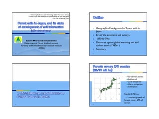
  • 1. Satoru Miura and Shinji Kaneko Department of Forest Site Environment Forestry and Forest Products Research Institute (FFPRI) Advancing the Science and Technology of Soil Information in Asia - Launch of GSP Asia Network and GlobalSoilMap.net East Asia Node 7-11th Feb, at Nanjing, China 1 1. Geographical background of forest soils in Japan 2. Era of the extensive soil surveys 3. (1950s–70s) 4. Measures against global warming and soil carbon stock (1990s- ) 5. Summary 2 3 4 Rainfall 1,700 mm → Luxuriant growth of forests covers 67% of terrain Four climatic zones: Sub-boreal Cool temperate Warm temperate Subtropical
  • 2. 5 Secondary deciduous  board leaved forests Sugi plantation forest Evergreen broad  leaved forest Beech forest 6 Materials in ICG 2001 7 The Japanese Archipelago lying on the Ring of Fire Fresh soil materials Volcanic ash soils 8 1. Cool to warm, and humid → Luxuriant forest development 2. Sub-boreal to subtropical → High biodiversity 3. Steep slope and volcanic ash → Young fresh materials for soils cl:Climate o:Organisms r:Topography p:Parent material t:Time
  • 3. 9 10 Soil Group Soil Unit, WRB Area (%) Brown fores t soil Cambisols, Andosols 69.5 Black soil Andosols 12.4 Podzolic soil Podzols 3.8 Immature soil Regosols, Aren osols, Fluvisols, Leptosols 4.2 Red and Yello w soil, Dark re d soil, Gley soi l, Peaty soil, (Rock and deb ris) Acrisols, Alisols, Cambisols, Luvi sols, Gleysols, Regosols, Aren osols, Fluvisols, Leptosols 6.8 11 1. Timber demand gone up since 1950s → Soil survey over the country → land suitability for tree species 2. Established classification (Forest soil division, 1976); morphology and “catena” Color and structure dry ← moist → wet BA, BB, BC, BD, BE, BF 3. Management body worked out Several ten thousand soil pits many soil maps BD BlD Im 12 Forestry Agency (2009) 1 2 3 4 5 6 7 8 9 10 11 12 13 14 15 16 17 18 19+ 0 400 800 1,200 1,800 Age class (x 5 → year-old)Area(103ha) 02 92 82 72 62 52 47
  • 4. 13 1951 1966 1971 1976 1981 1986 1990 1995 2002 2007 0 5 10 15 20 25 (mil. ha) Forestry Agency (2009) Forest area Growing stock Planted Natural Others Planted Natural and others 1952 1966 1971 1976 1981 1986 1990 1995 2002 2007 0 1000 2000 3000 4000 (mil. m3) 14 1. Forest soil surveys all over Japan for timber production 2. Rapid increase of planted conifer forests 3. Clarified basic characteristics and distribution of forest soils in Japan 15 16 1. UN Conf on Environment and Development (1992) 2. Kyoto Protocol (1997) to UNFCCC –3.9% of –6% target assigned to forest management → Studies on carbon stock and change in forest Compilation of era of extensive soil surveys
  • 5. 17 Soil Unit N 0–30 cm (kgC m-2) 0–100 cm (kgC m-2) Moist Brown forest soil 1259 9.2 19.5 Black soil 414 13.8 33.0 Dry Podzolic soil 199 10.1 20.8 Immature soil 88 3.9 8.2 Area-weighed average 3363 9.0 18.8 Global mean 11.3 Cool temperate wet 13.9 New Zealand 15.9 Morisada et al. (2004) 18 1st : 1950s-70s 3400 points compiled ← 86% in national forest 5 cm 30 cm 15 cm 0 cm N EW S 2nd : 2006-2010 2500 points, 28%(NF) 4x20 km, link to NFI 0.1 ha ø35.7 m 19 ca. 7 kgC m-2 (2006-2010) 9.0 kgC m-2 (50s-70s) 20 Removal of litter, foliage, root might cause carbon decrease Walter Weston (1922) Seikei zusetsu (1804)
  • 6. 21 CH4: 91 GgC yr -1 (49-136) N2O 1.9 GgN yr -1 (0.7-5.2) Hashimoto et al. (2011) Net absorption! Average flux Annual flux Adsorption Emission 22 1. Compilation of soil survey data during “Era of the extensive soil surveys (1950s–70s)” 2. Promote 2nd phase of more systematic national soil surveys (2006-2010) 3. Other relevant research outcomes based on nation-wide soil map and survey data 23 1. Japan-wide soil map (1:200,000) covering both agricultural and forested area by National Land Survey Division, Ministry of Land, Infrastructure, Transport and Tourism (MLIT) in 1970s 2. MLIT provides National Land Numerical Information; nature of basic land classification, climate 3. Geospatial Information Authority of Japan (GSI) provides DEM → Fulfilling data for soil and soil forming factors 24 1. Infrastructure of forest soil data in Japan built up by timber demand and global warming issues independently from agricultural soils 2. Two phases of ground soil survey data compiled into database 3. Future tasks are – Development of systems for end-user Integration with the soil classification system for agricultural lands
  • 7. 25 Forestry and Forest Products Research Institute (FFPRI), Japan