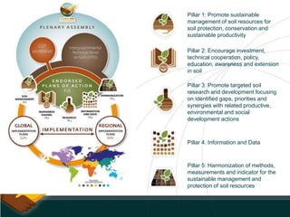
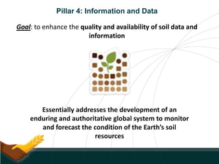
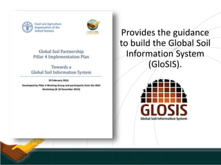
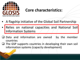
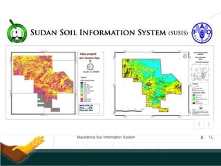
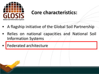
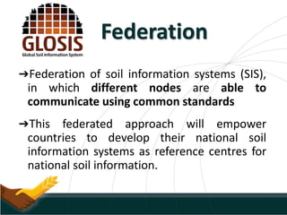
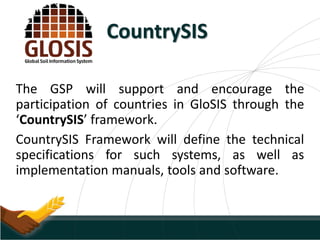
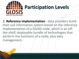
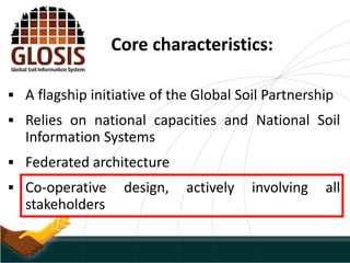
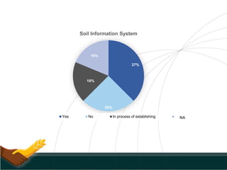
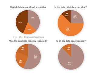
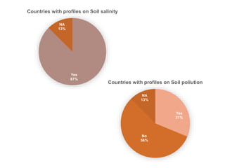
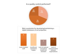
Towards a Global Soil
Information System
Ms. Lucrezia Caon, GSP Secretariat
Pillar 1: Promote sustainable
management of soil resources for
soil protection, conservation and
sustainable productivity
Pillar 2: Encourage investment,
technical cooperation, policy,
education, awareness and extension
in soil
Pillar 3: Promote targeted soil
research and development focusing
on identified gaps, priorities and
synergies with related productive,
environmental and social
development actions
Pillar 4: Information and Data
Pillar 5: Harmonization of methods,
measurements and indicator for the
sustainable management and
protection of soil resources
Pillar 4: Information and Data
Goal: to enhance the quality and availability of soil data and
information
Essentially addresses the development of an
enduring and authoritative global system to monitor
and forecast the condition of the Earth’s soil
resources
Provides the guidance
to build the Global Soil
Information System
(GloSIS).
Core characteristics:
 A flagship initiative of the Global Soil Partnership
 Relies on national capacities and National Soil
Information Systems
 Data and information are owned by the member
countries
 The GSP supports countries in developing their own soil
information systems (capacity development)
Core characteristics:
 A flagship initiative of the Global Soil Partnership
 Relies on national capacities and National Soil
Information Systems
 Federated architecture
Federation
➔Federation of soil information systems (SIS),
in which different nodes are able to
communicate using common standards
➔This federated approach will empower
countries to develop their national soil
information systems as reference centres for
national soil information.
CountrySIS
The GSP will support and encourage the
participation of countries in GloSIS through the
‘CountrySIS’ framework.
CountrySIS Framework will define the technical
specifications for such systems, as well as
implementation manuals, tools and software.
Participation Levels
The federative architecture will allow data providers to
choose between three different levels of adhesion to GloSIS:
1. Ad hoc implementation - a SIS, that based on
diverse technologies, is able to publish data
complying with the GloSIS data exchange model.
This is likely to be the case for the countries that
already have a SIS in place and wish to join
GloSIS.
2. Reference implementation - data providers build
their soil information system based on the reference
implementation of a GloSIS node, which is an off-
the-shelf, deployable bundle of technologies that
perform the functions of a node, plus data
management.
Participation Levels
3. Support implementation - for data providers
lacking the resources or knowledge to set up and
maintain a reference node.
In this case their data are stored and published by the
support node, thus automatically complying with the
GloSIS domain model and the data exchange.
Participation Levels
Core characteristics:
 A flagship initiative of the Global Soil Partnership
 Relies on national capacities and National Soil
Information Systems
 Federated architecture
 Co-operative design, actively involving all
stakeholders
• Strengthen national capacities on soil information
• Improved visibility of national SIS; enhance usability of soil data.
• Modernising existing SIS using diverse technologies
• Contribute to more consistent and accurate global soil data
products
• Decentralised resources and control;
• Better interoperability;
• to support (inter)national scientific research;
• to address trans-boundary issues.
• Supports private sector in countries to reach up-to-date soil
information and assess soil resources at multiscale.
Benefits for Countries
GloSIS – Gridded Data Products
➔ Global Soil Organic Carbon Map
(GSOCmap) (Launched – V1.2.0)
➔Global Soil Erosion Map (Concept Note)
➔Global Soil Salinity Map (Technical Specs)
➔Global Assessment of Soil Organic
Carbon Sequestration Potential(Technical Specs)
➔ Global Black Soil Distribution Map
(INBS) (Concept Note)
Challenges
Challenging to coordinate efforts
Difficult to overcome political
and data ownership issues
Requires consensus on
architecture, business rules and
semantics among disparate
groups
Complex and challenging
technical environment
GSP Secretariat
Soil Data Facility
GSP Data Policy (Endorsed by the GSP
Plenary Assembly)
GSP PA, GSP Secretariat, Soil Data
Facility, Pillar 5, Pillar 4, INSII
PROBLEM SOLUTION
Challenges
Ambitious Work Plan for Data
Products
Data sharing, ownership issues
Technical Product
Specifications, Guidelines,
Cookbook Manuals
Technical Capacities
GSP Secretariat (Resource Mobilisation,
Network, Delivery Mechanisms)
GSP Capacity Development Programme
GSP Data Policy (Endorsed by the GSP
Plenary Assembly)
P4WG, INSII, ITPS
IUSS GSM WG?
PROBLEM SOLUTION
Harmonisation Issues
The GloSIS Federation cannot
be built without consistent and
comparable harmonised soil
information.
Pillar 5 provides mechanisms
for collation, analysis and
exchange of consistent and
comparable global soil data
and information
How is behind Pillar 4?
• INSII - The International Network of Soil Information Institutions
forms the technical backbone of Pillar 4
• P4WG (Pillar 4 Working Group) The INSII network is supported
by a technical working group of soil information experts. It’s the
supervisory body of Pillar 4 implementation. Also, it conducts
tasks delegated by INSII
• SDF (GSP Soil Data Facility) is to provide technical and
infrastructural support to the Global Soil Information System
(GloSIS). ISRIC World Soil Information appointed by the GSP PA for
3 years mandate (2017-2020).
Country Representative in INSII
Algeria
Bahrain
Egypt
Iraq Waleed Muhammed Mikhlef Al-Shafie
Islamic Republic of Iran
Jordan
Kingdom Saudi Arabia
Kuwait
Lebanon
Libya
Morocco Rachid Moussadek
Oman
Palestine
Qatar
Sudan Abdelmagid Ali Elmobark
Syria
Tunisia Nadhem Brahim
Yemen Mohammed Hezam Al-Mashreki
It is very important for countries to be represented in these
groups and in INSII especially
Establishment of National Soil Information Systems
(NSIS)
- PROCEDURE -
1. Have a good idea of what is available at the national level.
Yes
68%
No
11%
NA
21%
Countries participating in the survey
Jordan & Saudi Arabia
Kuwati, Libya, Qatar,
United Arab Emirates
37%
25%
19%
19%
Soil Information System
Yes No In process of establishing NA
37%
19%
44%
Digital databases of soil properties
Yes No In process of establishing
Yes
25%
No
62%
NA
13%
Is the data publicly accessible?
Yes
87%
NA
13%
Is all the data georefrenced?
Yes
56%
No
25%
NA
19%
Was the database recently updated?
Yes
87%
NA
13%
Countries with profiles on Soil salinity
Yes
31%
No
56%
NA
13%
Countries with profiles on Soil pollution
Yes
31%
No
44%
NA
25%
Is a quality control performed?
6 6
3
4
Lack of skilled
staff
Insufficient
equipment
supply
Lack of national
conceptual
model and
standard
Lack of
communication
between
organizations
Main constraints for developing/maintaining a
digital databases of soil properties
11%
78%
11%
Soil Monitoring System
Yes No In process of establishing
Establishment of National Soil Information Systems
(NSIS)
- PROCEDURE -
1. Have a good idea of what is available at the national level. Fragmentation of data
should be overcome!
Country submission 1 Country submission 2
Publicly accessible Yes No
Data from before 1960 0 2930
1960-1990 40000 8178
1990-2010 46000 57
Data on Soil Salinity Yes No
Quality control Yes No
Table 1 Table highlighting contrasting answers submitted by the same country
Establishment of National Soil Information Systems
(NSIS)
- PROCEDURE -
1. Have a good idea of what is available at the national level. Fragmentation of data
should be overcome!
- STEP 1: National Focal Points to compile a list of institutions dealing with soil data.
Please specify which institutions you are in contact already and which ones you
are not.
- STEP 2: Ask the institutions identified in STEP 1 to answer the “Country Soil
Information Survey”
- STEP 3: make a country specific analysis.
o What are the barriers, limitations, gaps, etc. to data exchange?
o Study how to bring those data together and ultimately get these institutions
to work together?
2. Harmonize national databases (link to GLOSOLAN)
3. Produce maps, websites, etc. Only at this stage we can talk about NSIS

Towards a Global Soil Information System (GLOSIS)

  • 1.
    Towards a GlobalSoil Information System Ms. Lucrezia Caon, GSP Secretariat
  • 2.
    Pillar 1: Promotesustainable management of soil resources for soil protection, conservation and sustainable productivity Pillar 2: Encourage investment, technical cooperation, policy, education, awareness and extension in soil Pillar 3: Promote targeted soil research and development focusing on identified gaps, priorities and synergies with related productive, environmental and social development actions Pillar 4: Information and Data Pillar 5: Harmonization of methods, measurements and indicator for the sustainable management and protection of soil resources
  • 3.
    Pillar 4: Informationand Data Goal: to enhance the quality and availability of soil data and information Essentially addresses the development of an enduring and authoritative global system to monitor and forecast the condition of the Earth’s soil resources
  • 4.
    Provides the guidance tobuild the Global Soil Information System (GloSIS).
  • 5.
    Core characteristics:  Aflagship initiative of the Global Soil Partnership  Relies on national capacities and National Soil Information Systems  Data and information are owned by the member countries  The GSP supports countries in developing their own soil information systems (capacity development)
  • 7.
    Core characteristics:  Aflagship initiative of the Global Soil Partnership  Relies on national capacities and National Soil Information Systems  Federated architecture
  • 8.
    Federation ➔Federation of soilinformation systems (SIS), in which different nodes are able to communicate using common standards ➔This federated approach will empower countries to develop their national soil information systems as reference centres for national soil information.
  • 9.
    CountrySIS The GSP willsupport and encourage the participation of countries in GloSIS through the ‘CountrySIS’ framework. CountrySIS Framework will define the technical specifications for such systems, as well as implementation manuals, tools and software.
  • 10.
    Participation Levels The federativearchitecture will allow data providers to choose between three different levels of adhesion to GloSIS: 1. Ad hoc implementation - a SIS, that based on diverse technologies, is able to publish data complying with the GloSIS data exchange model. This is likely to be the case for the countries that already have a SIS in place and wish to join GloSIS.
  • 11.
    2. Reference implementation- data providers build their soil information system based on the reference implementation of a GloSIS node, which is an off- the-shelf, deployable bundle of technologies that perform the functions of a node, plus data management. Participation Levels
  • 12.
    3. Support implementation- for data providers lacking the resources or knowledge to set up and maintain a reference node. In this case their data are stored and published by the support node, thus automatically complying with the GloSIS domain model and the data exchange. Participation Levels
  • 13.
    Core characteristics:  Aflagship initiative of the Global Soil Partnership  Relies on national capacities and National Soil Information Systems  Federated architecture  Co-operative design, actively involving all stakeholders
  • 14.
    • Strengthen nationalcapacities on soil information • Improved visibility of national SIS; enhance usability of soil data. • Modernising existing SIS using diverse technologies • Contribute to more consistent and accurate global soil data products • Decentralised resources and control; • Better interoperability; • to support (inter)national scientific research; • to address trans-boundary issues. • Supports private sector in countries to reach up-to-date soil information and assess soil resources at multiscale. Benefits for Countries
  • 15.
    GloSIS – GriddedData Products ➔ Global Soil Organic Carbon Map (GSOCmap) (Launched – V1.2.0) ➔Global Soil Erosion Map (Concept Note) ➔Global Soil Salinity Map (Technical Specs) ➔Global Assessment of Soil Organic Carbon Sequestration Potential(Technical Specs) ➔ Global Black Soil Distribution Map (INBS) (Concept Note)
  • 16.
    Challenges Challenging to coordinateefforts Difficult to overcome political and data ownership issues Requires consensus on architecture, business rules and semantics among disparate groups Complex and challenging technical environment GSP Secretariat Soil Data Facility GSP Data Policy (Endorsed by the GSP Plenary Assembly) GSP PA, GSP Secretariat, Soil Data Facility, Pillar 5, Pillar 4, INSII PROBLEM SOLUTION
  • 17.
    Challenges Ambitious Work Planfor Data Products Data sharing, ownership issues Technical Product Specifications, Guidelines, Cookbook Manuals Technical Capacities GSP Secretariat (Resource Mobilisation, Network, Delivery Mechanisms) GSP Capacity Development Programme GSP Data Policy (Endorsed by the GSP Plenary Assembly) P4WG, INSII, ITPS IUSS GSM WG? PROBLEM SOLUTION Harmonisation Issues
  • 18.
    The GloSIS Federationcannot be built without consistent and comparable harmonised soil information. Pillar 5 provides mechanisms for collation, analysis and exchange of consistent and comparable global soil data and information
  • 19.
    How is behindPillar 4? • INSII - The International Network of Soil Information Institutions forms the technical backbone of Pillar 4 • P4WG (Pillar 4 Working Group) The INSII network is supported by a technical working group of soil information experts. It’s the supervisory body of Pillar 4 implementation. Also, it conducts tasks delegated by INSII • SDF (GSP Soil Data Facility) is to provide technical and infrastructural support to the Global Soil Information System (GloSIS). ISRIC World Soil Information appointed by the GSP PA for 3 years mandate (2017-2020).
  • 20.
    Country Representative inINSII Algeria Bahrain Egypt Iraq Waleed Muhammed Mikhlef Al-Shafie Islamic Republic of Iran Jordan Kingdom Saudi Arabia Kuwait Lebanon Libya Morocco Rachid Moussadek Oman Palestine Qatar Sudan Abdelmagid Ali Elmobark Syria Tunisia Nadhem Brahim Yemen Mohammed Hezam Al-Mashreki It is very important for countries to be represented in these groups and in INSII especially
  • 21.
    Establishment of NationalSoil Information Systems (NSIS) - PROCEDURE - 1. Have a good idea of what is available at the national level.
  • 22.
    Yes 68% No 11% NA 21% Countries participating inthe survey Jordan & Saudi Arabia Kuwati, Libya, Qatar, United Arab Emirates
  • 23.
    37% 25% 19% 19% Soil Information System YesNo In process of establishing NA
  • 24.
    37% 19% 44% Digital databases ofsoil properties Yes No In process of establishing Yes 25% No 62% NA 13% Is the data publicly accessible? Yes 87% NA 13% Is all the data georefrenced? Yes 56% No 25% NA 19% Was the database recently updated?
  • 25.
    Yes 87% NA 13% Countries with profileson Soil salinity Yes 31% No 56% NA 13% Countries with profiles on Soil pollution
  • 26.
    Yes 31% No 44% NA 25% Is a qualitycontrol performed? 6 6 3 4 Lack of skilled staff Insufficient equipment supply Lack of national conceptual model and standard Lack of communication between organizations Main constraints for developing/maintaining a digital databases of soil properties
  • 27.
    11% 78% 11% Soil Monitoring System YesNo In process of establishing
  • 28.
    Establishment of NationalSoil Information Systems (NSIS) - PROCEDURE - 1. Have a good idea of what is available at the national level. Fragmentation of data should be overcome! Country submission 1 Country submission 2 Publicly accessible Yes No Data from before 1960 0 2930 1960-1990 40000 8178 1990-2010 46000 57 Data on Soil Salinity Yes No Quality control Yes No Table 1 Table highlighting contrasting answers submitted by the same country
  • 29.
    Establishment of NationalSoil Information Systems (NSIS) - PROCEDURE - 1. Have a good idea of what is available at the national level. Fragmentation of data should be overcome! - STEP 1: National Focal Points to compile a list of institutions dealing with soil data. Please specify which institutions you are in contact already and which ones you are not. - STEP 2: Ask the institutions identified in STEP 1 to answer the “Country Soil Information Survey” - STEP 3: make a country specific analysis. o What are the barriers, limitations, gaps, etc. to data exchange? o Study how to bring those data together and ultimately get these institutions to work together? 2. Harmonize national databases (link to GLOSOLAN) 3. Produce maps, websites, etc. Only at this stage we can talk about NSIS