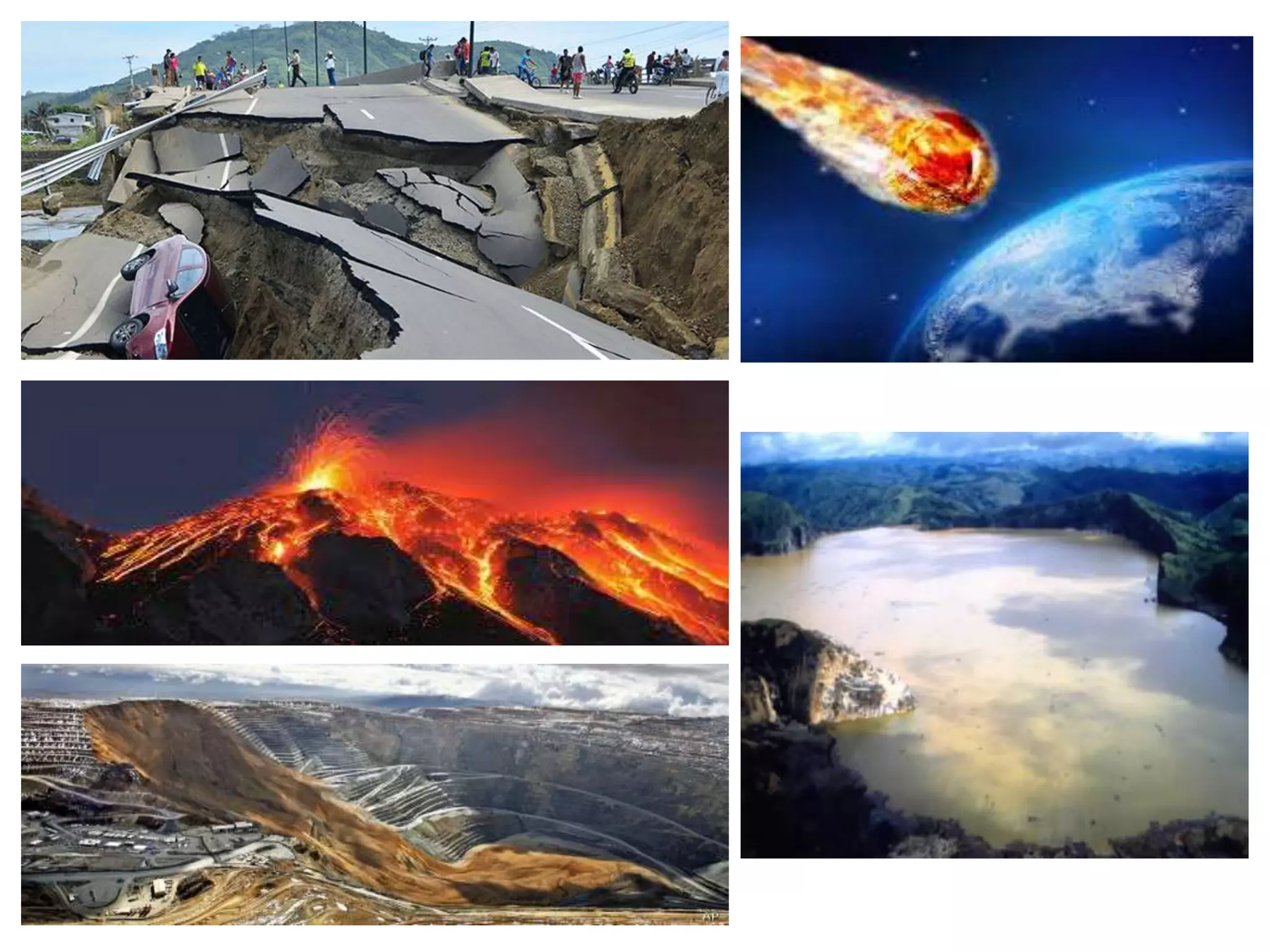
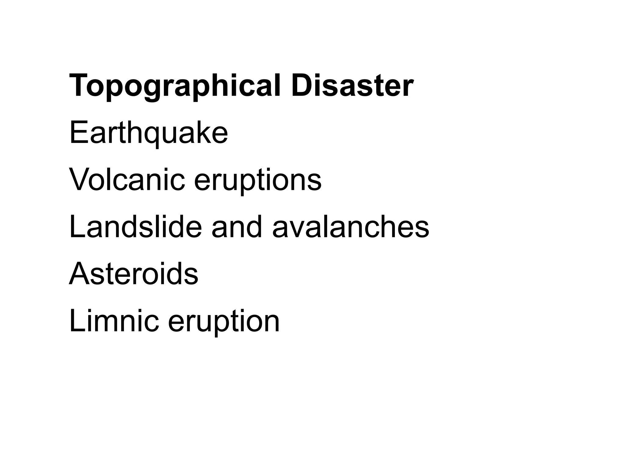
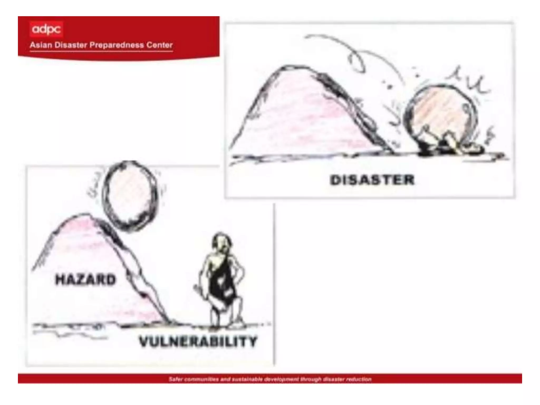
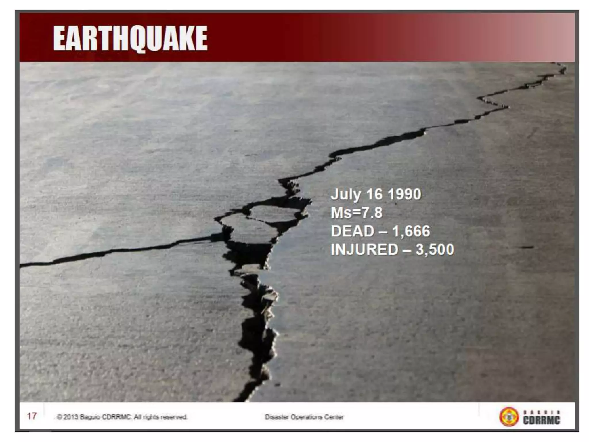
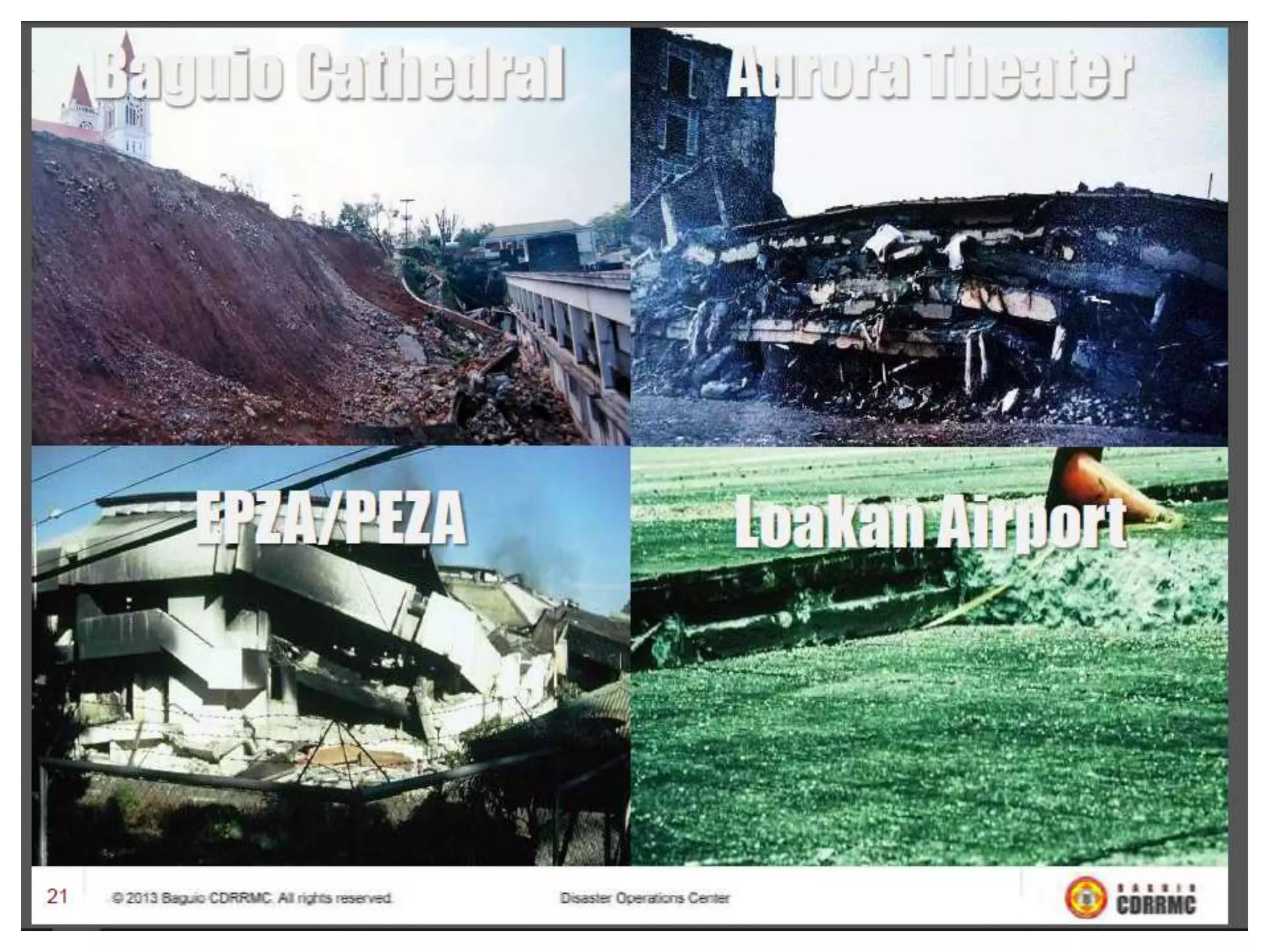
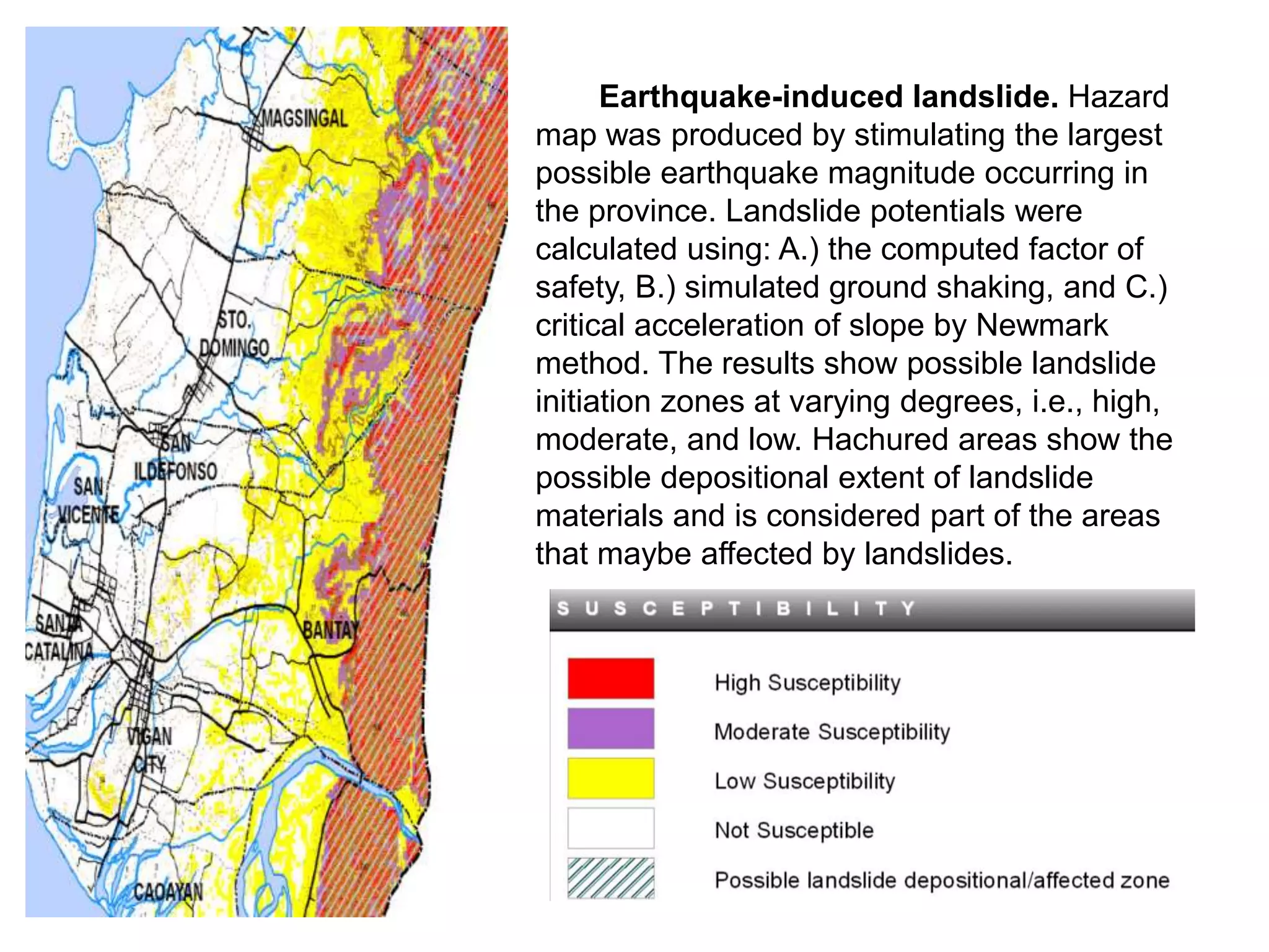
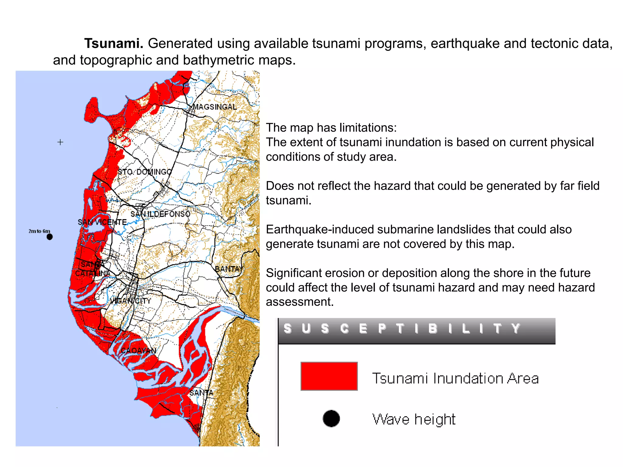
Video of Ring fire
Topographical Disaster
Earthquake
Volcanic eruptions
Landslide and avalanches
Asteroids
Limnic eruption
THE BASIC CONCEPTS OF
THE FOLLOWING HAZARDS:
earthquake, volcano, tsunami, typhoons as
well as what to do before, during and after
are in the brochures/ leaflets given by DOST
SEI/PHIVOCS
Earthquake hazard???
Earthquake
• An earthquake is the result of a sudden
release of energy in the earth’s crust that
creates seismic waves
• the seismic activity of an area refers to
frequency, type and size of earthquakes
experienced over the period of time
Videos Explaining Earthquakes
POTENTIAL EARTHQUAKE
HAZARDZ
GROUND SHAKING – shaking of the
ground caused by passage of seismic wave,
especially during an earthquake
Ground Rupture – shaking of the ground
caused by the passage of seismic waves,
especially surface wave near the epicenter
of the earthquake are responsible for the
most damage during earthquake.
What is intensity??
What is magnitude??
Videos Magnitudes vs Intensity
Video's fault
Liquefaction – liquefaction is a
phenomenon in which the strength and
stiffness of soil is reduced by earthquake
shaking or other rapid loading
Earthquake – Induced ground subsidence –
ground subsidence can result from the
settlement of native low density soils, or the
caving in of natural or man made
underground voids
Tsunami - a series of wave in a water body
caused by the displacement of a large
volume of water, generally in the ocean or a
large lake
Earthquake – Induced landslide - a form
of mass wasting that includes a wide range
of ground movement
Earthquake-induced landslide. Hazard
map was produced by stimulating the largest
possible earthquake magnitude occurring in
the province. Landslide potentials were
calculated using: A.) the computed factor of
safety, B.) simulated ground shaking, and C.)
critical acceleration of slope by Newmark
method. The results show possible landslide
initiation zones at varying degrees, i.e., high,
moderate, and low. Hachured areas show the
possible depositional extent of landslide
materials and is considered part of the areas
that maybe affected by landslides.
Ground Rupture. Active fault in this area
have been recognized based on the study of aerial
photographs, satellite imagery, topographic maps,
historical seismicity and/or surface rupture,
previous publications and field investigation. These
active faults have been mapped and classified
based on identification of tectonically produced
landforms and other geologic and geomorphic
evidence of recent faulting.
Major faults with recent earthquake may
probably exist below the surface (blind or deep
faults) but these features will not be recognized by
the methodology used. Detailed geophysical
investigation should be conducted to identify and
characterize the faults.
Ground shaking. This is a composite map
of estimates of maximum intensities for various
earthquake scenarios that may affect the study
area. Intensities were determined using a
deterministic method. Fault parameters and
maximum credible magnitude used for different
earthquakes scenario were based on instrumental
seismicity, historical seismicity and mapped active
earthquake generators in the area.
The ground shaking maps do not
restrict construction of any structure or
land development in areas with expected
high intensities if the national building
code is followed.
This map is ideal for land use,
emergency response and mitigation
planning, but should not replace site
specific evaluations for the building of
critical structures.
Tsunami. Generated using available tsunami programs, earthquake and tectonic data,
and topographic and bathymetric maps.
The map has limitations:
The extent of tsunami inundation is based on current physical
conditions of study area.
Does not reflect the hazard that could be generated by far field
tsunami.
Earthquake-induced submarine landslides that could also
generate tsunami are not covered by this map.
Significant erosion or deposition along the shore in the future
could affect the level of tsunami hazard and may need hazard
assessment.
Hazard maps. People and properties are affected by earthquake due to any or a
combination of the following: unsafe location, poor construction, people do not believe or
know that they be affected, people do not know how they can be affected, people do not
know what to do, and there is lack of timely and proper response.
Scientists have for so long studied earthquake occurrences and the hazards associated
with them by looking at impacts on major earthquakes. Based on studies, given a specific
earthquake scenario (magnitude) maps showing areas likely to be affected by a certain
specific hazard and the degree of expected impact are generated. The purpose is to be able
to use these maps.
These maps were generated to provide the most accurate and detailed information
possible to assist engineers in designing buildings, bridges, highways, and utilities that will
withstand shaking from earthquakes in an area. These maps are used by local governments
to help establish zoning, construction requirements necessary to preserve public safety and
for purposes of general planning for disaster risk reduction and mitigation.
Before using the map, make sure that you understand the basic parts:
A. Map Title (tells you what the map is all about);
B. Legend (details of what each symbol means); and
C. Scale (refer to the bar scale as this helps determine distances).

Earthquake Hazard.ppt

  • 2.
  • 3.
  • 6.
    THE BASIC CONCEPTSOF THE FOLLOWING HAZARDS: earthquake, volcano, tsunami, typhoons as well as what to do before, during and after are in the brochures/ leaflets given by DOST SEI/PHIVOCS
  • 7.
  • 8.
    Earthquake • An earthquakeis the result of a sudden release of energy in the earth’s crust that creates seismic waves • the seismic activity of an area refers to frequency, type and size of earthquakes experienced over the period of time
  • 9.
  • 10.
    POTENTIAL EARTHQUAKE HAZARDZ GROUND SHAKING– shaking of the ground caused by passage of seismic wave, especially during an earthquake Ground Rupture – shaking of the ground caused by the passage of seismic waves, especially surface wave near the epicenter of the earthquake are responsible for the most damage during earthquake.
  • 11.
  • 12.
  • 13.
  • 21.
    Liquefaction – liquefactionis a phenomenon in which the strength and stiffness of soil is reduced by earthquake shaking or other rapid loading Earthquake – Induced ground subsidence – ground subsidence can result from the settlement of native low density soils, or the caving in of natural or man made underground voids
  • 22.
    Tsunami - aseries of wave in a water body caused by the displacement of a large volume of water, generally in the ocean or a large lake Earthquake – Induced landslide - a form of mass wasting that includes a wide range of ground movement
  • 23.
    Earthquake-induced landslide. Hazard mapwas produced by stimulating the largest possible earthquake magnitude occurring in the province. Landslide potentials were calculated using: A.) the computed factor of safety, B.) simulated ground shaking, and C.) critical acceleration of slope by Newmark method. The results show possible landslide initiation zones at varying degrees, i.e., high, moderate, and low. Hachured areas show the possible depositional extent of landslide materials and is considered part of the areas that maybe affected by landslides.
  • 24.
    Ground Rupture. Activefault in this area have been recognized based on the study of aerial photographs, satellite imagery, topographic maps, historical seismicity and/or surface rupture, previous publications and field investigation. These active faults have been mapped and classified based on identification of tectonically produced landforms and other geologic and geomorphic evidence of recent faulting. Major faults with recent earthquake may probably exist below the surface (blind or deep faults) but these features will not be recognized by the methodology used. Detailed geophysical investigation should be conducted to identify and characterize the faults. Ground shaking. This is a composite map of estimates of maximum intensities for various earthquake scenarios that may affect the study area. Intensities were determined using a deterministic method. Fault parameters and maximum credible magnitude used for different earthquakes scenario were based on instrumental seismicity, historical seismicity and mapped active earthquake generators in the area.
  • 25.
    The ground shakingmaps do not restrict construction of any structure or land development in areas with expected high intensities if the national building code is followed. This map is ideal for land use, emergency response and mitigation planning, but should not replace site specific evaluations for the building of critical structures.
  • 26.
    Tsunami. Generated usingavailable tsunami programs, earthquake and tectonic data, and topographic and bathymetric maps. The map has limitations: The extent of tsunami inundation is based on current physical conditions of study area. Does not reflect the hazard that could be generated by far field tsunami. Earthquake-induced submarine landslides that could also generate tsunami are not covered by this map. Significant erosion or deposition along the shore in the future could affect the level of tsunami hazard and may need hazard assessment.
  • 27.
    Hazard maps. Peopleand properties are affected by earthquake due to any or a combination of the following: unsafe location, poor construction, people do not believe or know that they be affected, people do not know how they can be affected, people do not know what to do, and there is lack of timely and proper response. Scientists have for so long studied earthquake occurrences and the hazards associated with them by looking at impacts on major earthquakes. Based on studies, given a specific earthquake scenario (magnitude) maps showing areas likely to be affected by a certain specific hazard and the degree of expected impact are generated. The purpose is to be able to use these maps. These maps were generated to provide the most accurate and detailed information possible to assist engineers in designing buildings, bridges, highways, and utilities that will withstand shaking from earthquakes in an area. These maps are used by local governments to help establish zoning, construction requirements necessary to preserve public safety and for purposes of general planning for disaster risk reduction and mitigation. Before using the map, make sure that you understand the basic parts: A. Map Title (tells you what the map is all about); B. Legend (details of what each symbol means); and C. Scale (refer to the bar scale as this helps determine distances).