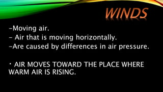
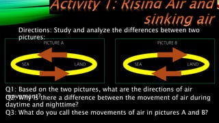
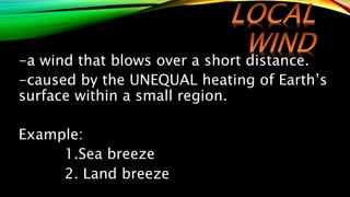
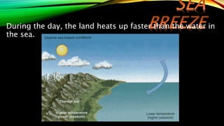
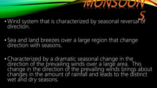
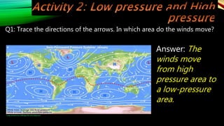
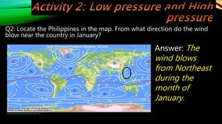
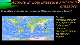
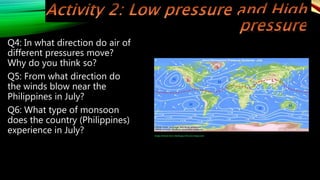
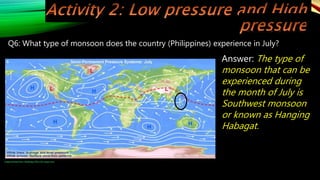
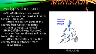
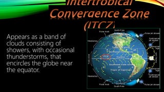
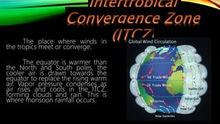
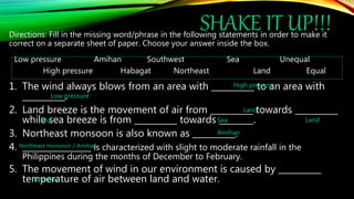
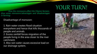
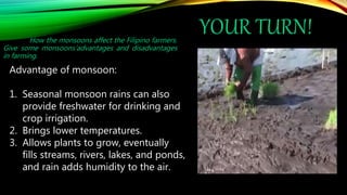
The document discusses atmospheric phenomena such as breezes, monsoons, and the intertropical convergence zone. It explains that breezes are winds that blow over short distances and are caused by the unequal heating of the Earth's surface. Monsoons are seasonal wind systems characterized by reversal of wind directions. The Philippines experiences the northeast monsoon from October to March and the southwest monsoon from July to September. The monsoons affect farming in the Philippines both positively, through providing water for irrigation, and negatively, through potential flooding.
1. The document discusses land and sea breezes, which occur due to differences in how quickly land and water heat up and cool down over the course of a day.
2. It also explains how monsoons are wind systems affected by proximity to large bodies of land and water. During certain seasons, differences in temperature and pressure cause seasonal winds called monsoons to develop.
3. Specifically, it describes the northeast and southwest monsoons that affect the Philippines, bringing cooler weather from December to February and rain from July to September, respectively.
This is an almost complete instructional material based from MELC in Grade 7 Science.
This is only applicable to the teachers in the Philippines. If you have any questions and wanted to avail the powerpoint you may contact me in my Facebook account: Jady Claire Jackson Lullegao
The document discusses key concepts about determining locations on Earth using latitude and longitude.
Latitude is measured in degrees north and south of the equator, which divides the Earth into the Northern and Southern Hemispheres. Longitude is measured in degrees east and west of the Prime Meridian passing through Greenwich, England. Together, lines of latitude and longitude can be used to precisely identify any location on Earth.
COT Grade 7 Biotic and Abiotic Components of EcosystemDominic Asis
This document outlines a lesson plan on biotic and abiotic components of an ecosystem. The objectives are to differentiate between biotic and abiotic components, give examples of each, and discuss their relationship and importance. There are several classroom activities, including identifying characteristics of living vs non-living things, explaining relationships between example biotic and abiotic factors, and a discussion of how pollution affects the ecosystem relationship. A take-home assignment involves reading about plastic pollution's effects on Philippine rivers and river life.
This document provides information about the 7th grade science unit on earth and space. It discusses key concepts like latitude and longitude and how they are used to describe locations. Lines of latitude run parallel to the equator and are used to measure positions north and south, while lines of longitude run from the North Pole to the South Pole and are used to measure positions east and west. Together, latitude and longitude provide an exact way to specify locations on Earth. The document also explains how latitude affects climate, with locations closer to the equator generally being warmer and those closer to the poles being colder.
Visualizing Motion Using Tape Charts and Motion Graphs.pptxmarsquijano
This document discusses using tape charts and motion graphs to analyze motion. It describes a scenario where a suspect in a hit and run case denies involvement, claiming they were driving slowly at a constant speed. However, oil spots from the suspect's car are found and can be used to create a tape chart representing the motion of the car. Tape charts are produced by a ticker-tape timer and show the time and distance of motion through a series of dots, allowing analysis of whether the motion was constant, accelerating, or decelerating.
The document discusses the benefits of exercise for mental health. Regular physical activity can help reduce anxiety and depression and improve mood and cognitive function. Exercise causes chemical changes in the brain that may help protect against mental illness and improve symptoms.
Location of the Philippines with respect to landmasses and bodies of waterSimple ABbieC
The document discusses the benefits of exercise for mental health. Regular physical activity can help reduce anxiety and depression and improve mood and cognitive functioning. Exercise causes chemical changes in the brain that may help protect against mental illness and improve symptoms for those who already suffer from conditions like anxiety and depression.
The document discusses the causes of seasons and eclipses. It explains that the seasons are caused by four main factors: the tilt of the Earth's axis, which results in one hemisphere receiving more direct sunlight; the Earth's revolution around the sun, which affects the exposure of each hemisphere to solar energy; the direct rays of sunlight, with more direct exposure resulting in warmer weather; and the length of daylight, with longer days exposing an area to more solar energy. Eclipses occur when the sun, moon, and Earth are perfectly aligned, allowing either the moon to block the sun during a solar eclipse or the Earth to block the moon during a lunar eclipse. Eclipses can be either total within the umbra shadow or
The document provides instructions for focusing a specimen under a compound microscope. It describes 8 steps: 1) Positioning the microscope towards diffused light, 2) Inserting a low power eyepiece, 3) Rotating in a low power objective, 4) Adjusting the mirror to see a bright field of view, 5) Placing a slide on the stage and fixing it, 6) Looking from the side and using the coarse adjustment knob to lower the objective close to the slide, 7) Looking through the eyepiece and raising the objective to see the specimen image, 8) Rotating in the high power objective and using the fine adjustment knob to get a sharp focused image.
The document summarizes the history and components of microscopes. It explains that while simple microscopes date back thousands of years, the compound microscope was developed in the late 16th century by Hans Janssen and Zacharias Janssen in Holland. Major improvements were made by Anthony van Leeuwenhoek and Robert Hooke. The document then describes the basic parts of a microscope including the objective lenses, ocular lens, stage, light source, and how magnification is calculated. It concludes with brief descriptions of other types of microscopes such as fluorescence, pocket, and dissecting microscopes.
Properties of saturated and unsaturated solutiondona guevarra
The document discusses saturated and unsaturated solutions. It defines a solution as a uniform mixture of a solute and solvent. A saturated solution contains the maximum amount of solute that can dissolve in a given amount of solvent, while an unsaturated solution contains less than the maximum amount of solute, meaning more can still dissolve. It explains that the solubility of a substance determines whether it will dissolve in a solvent to form a solution.
This document discusses factors that affect climate and weather patterns in the Philippines. It explains that climate is the average weather over time and is influenced by latitude, altitude, proximity to bodies of water, ocean currents, and topography. Temperature and rainfall are most affected by latitude, with equatorial regions experiencing higher temperatures and rainfall. Altitude, land/water distribution, winds, and monsoon patterns also impact regional climates. The Philippines experiences two pronounced monsoon seasons - the northeast monsoon from December to January and the southwest monsoon from July to September.
Module 2 solar energy and the atmosphereArchie Duran
The document discusses the layers of the atmosphere and their properties. It begins with the troposphere, the lowest layer where weather occurs. Above is the stratosphere, with little water vapor and the ozone layer. The mesosphere is very cold, and meteors burn up there. The thermosphere contains the ionosphere and auroras. The uppermost exosphere merges with space. The atmosphere protects the Earth and supports life through greenhouse gases like carbon dioxide and water vapor that trap heat. Human activities like burning fossil fuels have increased greenhouse gases and global warming, causing climate change effects.
1) Tropical cyclones originate in the Intertropical Convergence Zone near the equator where trade winds from the northern and southern hemispheres converge.
2) A typhoon is a tropical cyclone that forms over the northwest Pacific ocean, characterized by strong counterclockwise rotating winds around a low-pressure eye.
3) Two key factors fuel the formation and strengthening of a typhoon - rapid updrafts of warm moist air from the ocean surface, and the condensation and release of heat from this water vapor into the swirling winds.
1) Eclipses occur when one celestial body blocks the light from another. Lunar eclipses happen during a full moon when the Earth casts its shadow on the moon. Solar eclipses occur during a new moon when the moon passes between the Earth and sun.
2) There are three types of lunar eclipses - total, partial, and penumbral - and three types of solar eclipses - total, partial, and annular.
3) Eclipses do not occur every month because the moon's orbit is tilted relative to the Earth's orbit around the sun. Lunar eclipses are more frequent than solar eclipses.
Ecology is the study of how organisms interact with each other and their environment. Organisms are affected by biotic factors like other living things as well as abiotic factors like temperature, sunlight, and rocks that are non-living. A biome is a large geographic region defined by the plants and animals living there. There are two main types of biomes - terrestrial biomes like tropical forests, tundras, and deserts, as well as aquatic biomes including freshwater ecosystems like lakes and rivers, and marine ecosystems like coral reefs and oceans. Biomes provide habitat for many interconnected species but are threatened by human impacts like climate change and habitat destruction.
This document discusses monsoons and wind patterns in the Philippines. It begins by explaining the objectives, which are to interpret maps of wind direction, explain seasonal temperature changes, illustrate why the habagat wind brings heavy rain, and discuss how monsoons affect people. It then provides figures showing wind direction in January and July, explaining that low pressures in January cause the amihan northeast winds while low pressures in Australia cause the habagat southwest winds in July. The document concludes by discussing how the Intertropical Convergence Zone (ITCZ) causes rising warm air at the equator, resulting in converging winds and rain storms.
Science 7-4th Quarter The Philippine EnvironmentMerra Mae Ramos
The document discusses the location of the Philippines using latitude and longitude. It describes how latitude and longitude can be used to pinpoint the specific location of Manila at 14°N, 121°E. While a single point can locate a city, describing the location of a country requires indicating the range of latitudes and longitudes that define its boundaries, which can be approximated using a rectangular boundary. The document also provides background on lines of latitude and longitude, and names important parallels that delineate climate zones around the world.
A detailed lesson plan in Science 8
I. Objectives
At the end of the period, the student must be able to:
1. Perform the activity 1: Colors of the rainbow…colors of light
2. Identify the different colors of light after passing through the prism
3. Describe and give the reason behind the hierarchy of colors based on the observed results of the activity
4. Explain how refraction and dispersion takes place
The document discusses stars, constellations, and the universe. It explains that the universe was created by the Big Bang over 13 billion years ago and contains many galaxies. Stars are large spheres of gases like hydrogen and helium that form from spinning balls of gas. They come in different colors depending on their temperature. There are over 100 billion billion stars in the universe. Constellations are patterns of stars in the sky that different cultures have associated with characters or animals. Star charts can help identify constellations by connecting the stars and accounting for their positions from different locations on Earth.
This lesson plan covers the formation and development of typhoons. It includes objectives, content understanding, learning resources, activities to engage students, and an assessment. Students will learn that typhoons form from warm, moist air rising over the ocean and condensing into clouds and rainfall. As more warm air rises to replace the air that formed the clouds, winds begin to circulate, potentially strengthening into a typhoon. The lesson uses videos, diagrams, and questions to help students understand the factors and step-by-step process of how typhoons form and develop.
The Philippines is an archipelago located in Southeast Asia between Taiwan and Borneo. It comprises over 7,600 islands with a total land area of 300,000 square kilometers. The archipelago stretches from latitude 4°34' N to latitude 21°10' N, and longitude 116°40' E to longitude 127°8' E, making it the world's 5th largest island country. The islands are divided into three main groups - Luzon, Visayas, and Mindanao. The largest island is Luzon, containing over 40% of the country's total land area. Manila, the capital city, is located on Luzon.
1. The document discusses the different levels of biological organization from atoms to the biosphere.
2. It provides descriptions and examples for each level, from the smallest levels of atoms and molecules, to organelles, cells, tissues, organs, organ systems, organisms, populations, communities, ecosystems, biomes, and the biosphere.
3. The levels of organization show how simple structures combine to form more complex living things, with implications that harm at one level can affect higher levels of organization.
Weather - Winds, air masses, air pressures, frontsBrandi
Weather occurs due to convection currents in the atmosphere caused by uneven heating from the sun. Warm air rises at the equator forming clouds, while cool air sinks at the poles. High and low pressure systems move across the globe along jet streams, bringing different weather depending on whether air is ascending or descending. Fronts separate air masses and influence whether conditions are sunny or stormy as warm and cold air interact.
Here are sample responses to the scenarios provided:
1. I would wear warm winter clothes like a thick coat, hat, gloves and boots. This is because at 60 degrees north latitude in January, it would be very cold as this location is within the Arctic circle and experiencing winter.
2. I would wear lightweight clothes like shorts and short sleeves since it would be hot and humid. This is because at 10 degrees north latitude in February, it would experience little seasonal variation and remain warm throughout the year being close to the equator.
3. I would wear summer clothes like t-shirt and pants. Though it would be warmer than winter, the temperature would still be milder than locations closer to the equator. This
Factors Affecting the Climate Grade 9 Quarter 3 Week 4OskarOida
1. The document discusses various factors that affect climate, including latitude, altitude, topography, ocean currents, wind systems, and the Earth's movement.
2. Specific wind systems that influence the Philippines' climate are discussed, such as the northeast and southwest monsoons.
3. Different factors like latitude, altitude, proximity to oceans, and landforms cause areas to experience varying weather patterns and temperatures.
The document discusses factors that affect climate, including latitude. It differentiates between weather, which describes short-term atmospheric conditions, and climate, which refers to long-term patterns. An activity asks students to identify statements as referring to weather or climate. Examples show weather in Manila and climate in Metro Manila. Places are classified into tropical, temperate, and polar regions based on location. Questions cover how the tilt of Earth's axis and latitude impact the amount of sunlight and heat received in different areas, affecting regional climates.
Secondary Three Geography: Elements-Winds and PressureCarol LMr
The document discusses pressure and winds. It defines key terms like air pressure and its inverse relationship with altitude. It explains how differences in air pressure cause winds to flow from high to low pressure areas. Examples of winds discussed include sea and land breezes on a small scale, caused by differential heating of land and sea. Large scale monsoon winds are also summarized, with details about the seasonal southwest and northeast monsoons in India driven by pressure differences between the Asian landmass and Indian subcontinent. The Coriolis effect's role in deflecting winds is also noted.
There are four main types of air masses that form in different regions and have distinct temperature and moisture properties: continental, maritime, polar, and tropical. Weather fronts occur when different air masses meet, with three main types being cold fronts, warm fronts, and stationary fronts. Cold fronts move quickly and can produce thunderstorms and cooler temperatures, while warm fronts move more slowly and bring humid conditions and rain. Stationary fronts occur when air masses meet but neither overtakes the other, resulting in prolonged, unchanging weather.
The global atmospheric circulation system transports heat around the Earth's atmosphere and affects climate and weather patterns. It involves warm air rising at the equator and cold air sinking at the poles, creating circulation cells. Without this system, temperatures would become more extreme between the tropics and poles.
Typhoons form over warm ocean waters between June and November in the Philippines. During these months, the country receives a high amount of heat from the sun which causes the ocean water to evaporate rapidly. This forms warm, moist air above the ocean surface. The differences in air pressure and temperature lead to strong winds that can tighten into a large spiral around a calm center, forming a typhoon. Typhoons bring heavy rain, strong winds, coastal flooding, and dangerous waves.
The document discusses the two movements of the Earth - rotation and revolution. Rotation is the spinning of the Earth on its axis from west to east, taking 23 hours, 56 minutes and 4.2 seconds to complete one rotation. Revolution is the Earth's orbit around the Sun, taking 365 1/4 days to complete one revolution. Due to these motions, we experience day and night, seasons, sunrise and sunset, Coriolis effect, different time zones, and heat zones.
The daily lesson plan covers teaching students about the Earth's rotation and revolution over the course of a week. Each day focuses on a different learning objective related to these concepts. Activities include demonstrating how the Earth's rotation causes day and night using a globe and flashlight, and illustrating the Earth's revolution around the sun by tying a string to a pencil and moving it in a circular motion around a pushpin representing the sun. Formative assessments include multiple choice and true/false questions testing student understanding of concepts like seasons, day/night, and the Earth's movements.
1. The document is a science module that discusses atmospheric phenomena such as breezes, monsoons, and the Intertropical Convergence Zone (ITCZ).
2. It contains two lessons - the first discusses the behavior of heated air and surrounding air, including demonstrations that heated air rises due to lower density. The second lesson explains atmospheric phenomena.
3. Activities include comparing how fast sand and water warm up when exposed to sunlight, demonstrating rising warm air using a paper bag and candle, and showing air movement inside and outside a box with a lighted candle and smoke from a mosquito coil.
The document provides information about atmospheric and oceanic circulation processes. It includes diagrams of sea surface temperatures, atmospheric pressure maps, ocean currents, and El Niño conditions. Students are asked questions about these topics to assess their understanding of how atmospheric and oceanic circulation are interdependent and influence weather and climate patterns globally.
Climate is a long term condition happened in a specific place. While, weather is a short-term condition happened in a specific area and specific time. The factors affecting climate are latitude, altitude, topography, distance of bodies of water
Weather winds, air masses, air pressures, frontsBrandi
Here are the quiz questions:
1. What causes convection in the atmosphere?
2. Why does warm air rise and cold air sink?
3. What are the four main air masses that affect the US?
4. What type of front brings clearing conditions after it passes through?
5. What type of front moves slowly with rain developing gradually ahead of it?
Take 5 minutes to answer the questions individually on your paper. Then we'll go over the answers together.
The document discusses the seasons of the Earth. It begins with an introduction to sea breezes and land breezes. It then covers a lesson on the seasons, including a video explaining how the Earth's tilt and revolution around the sun cause the seasons in the Northern and Southern Hemispheres. Students participate in hands-on activities using models of the Earth to illustrate how its axis and movement result in different seasons. They also complete tables to demonstrate their understanding. The importance of understanding seasons and the passage of time is emphasized.
This document provides an assignment on weather and climate topics including relative humidity, rainfall, and wind systems. It includes skills and concepts to be explained, such as the relationship between temperature and relative humidity, global cloud cover patterns, types of rainfall, and wind formation. The assignment contains multiple choice and short answer questions to test understanding of these concepts. Feedback is provided on a scale of 1 to 3, and students are prompted to self-reflect on their performance.
The document provides information about different types of winds and storms like cyclones, thunderstorms, tornadoes, and wind. It includes a student's name, class, roll number, and science group. The document then discusses learning objectives, textbook information, and exercises related to these atmospheric phenomena. Examples of how cyclones form and their destructive impacts are provided. Safety precautions for thunderstorms and explanations for various natural phenomena are also summarized.
The document is a science module that discusses how the tilt of the Earth's axis affects the length of daytime. It contains background information on the topic, example questions to assess understanding, and a lesson on how the tilt of the Earth's axis relates to variations in the length of daytime in different locations and seasons. The tilt of the Earth's axis at 23.5 degrees causes the length of daytime to vary from place to place and seasonally. When the North Pole tilts toward the Sun, locations in the Northern Hemisphere experience longer days and summer conditions, as they receive more direct sunlight.
1. The Earth revolves around the Sun in an elliptical orbit once every 365.25 days as it rotates on its tilted axis.
2. The tilt of the Earth's axis remains fixed as it orbits the Sun, causing the Northern and Southern Hemispheres to alternately face towards and away from the Sun over the course of a year.
3. When a hemisphere is tilted towards the Sun, it experiences summer, and the Sun appears higher in the sky, resulting in longer days. When tilted away, it experiences winter, and the Sun appears lower with shorter days.
This slide is special for master students (MIBS & MIFB) in UUM. Also useful for readers who are interested in the topic of contemporary Islamic banking.
How to Setup Warehouse & Location in Odoo 17 InventoryCeline George
In this slide, we'll explore how to set up warehouses and locations in Odoo 17 Inventory. This will help us manage our stock effectively, track inventory levels, and streamline warehouse operations.
This presentation was provided by Steph Pollock of The American Psychological Association’s Journals Program, and Damita Snow, of The American Society of Civil Engineers (ASCE), for the initial session of NISO's 2024 Training Series "DEIA in the Scholarly Landscape." Session One: 'Setting Expectations: a DEIA Primer,' was held June 6, 2024.
বাংলাদেশের অর্থনৈতিক সমীক্ষা ২০২৪ [Bangladesh Economic Review 2024 Bangla.pdf] কম্পিউটার , ট্যাব ও স্মার্ট ফোন ভার্সন সহ সম্পূর্ণ বাংলা ই-বুক বা pdf বই " সুচিপত্র ...বুকমার্ক মেনু 🔖 ও হাইপার লিংক মেনু 📝👆 যুক্ত ..
আমাদের সবার জন্য খুব খুব গুরুত্বপূর্ণ একটি বই ..বিসিএস, ব্যাংক, ইউনিভার্সিটি ভর্তি ও যে কোন প্রতিযোগিতা মূলক পরীক্ষার জন্য এর খুব ইম্পরট্যান্ট একটি বিষয় ...তাছাড়া বাংলাদেশের সাম্প্রতিক যে কোন ডাটা বা তথ্য এই বইতে পাবেন ...
তাই একজন নাগরিক হিসাবে এই তথ্য গুলো আপনার জানা প্রয়োজন ...।
বিসিএস ও ব্যাংক এর লিখিত পরীক্ষা ...+এছাড়া মাধ্যমিক ও উচ্চমাধ্যমিকের স্টুডেন্টদের জন্য অনেক কাজে আসবে ...
How to Build a Module in Odoo 17 Using the Scaffold MethodCeline George
Odoo provides an option for creating a module by using a single line command. By using this command the user can make a whole structure of a module. It is very easy for a beginner to make a module. There is no need to make each file manually. This slide will show how to create a module using the scaffold method.
This document provides an overview of wound healing, its functions, stages, mechanisms, factors affecting it, and complications.
A wound is a break in the integrity of the skin or tissues, which may be associated with disruption of the structure and function.
Healing is the body’s response to injury in an attempt to restore normal structure and functions.
Healing can occur in two ways: Regeneration and Repair
There are 4 phases of wound healing: hemostasis, inflammation, proliferation, and remodeling. This document also describes the mechanism of wound healing. Factors that affect healing include infection, uncontrolled diabetes, poor nutrition, age, anemia, the presence of foreign bodies, etc.
Complications of wound healing like infection, hyperpigmentation of scar, contractures, and keloid formation.
Strategies for Effective Upskilling is a presentation by Chinwendu Peace in a Your Skill Boost Masterclass organisation by the Excellence Foundation for South Sudan on 08th and 09th June 2024 from 1 PM to 3 PM on each day.
4. Warm Air
Surrounding Air
From the illustration, answer the following guide questions:
Q1: Is the movement of
warm air upward?
Answer: YES
5. Warm Air
Surrounding Air
From the illustration, answer the following guide questions:
Q2: Why is it that the
warm air rises?
Answer: Warm air
rises because it is less
dense than cold air
from its surrounding.
6. Warm Air
Surrounding Air
From the illustration, answer the following guide questions:
Q3: How will you describe
the movement of
surrounding air?
Answer: The
surrounding air move
towards where the
warm air is rising.
7. Warm Air
Surrounding Air
From the illustration, answer the following guide questions:
Q4: Compare the direction of
movements between
surrounding air and warm air.
Answer: The surrounding
air move downward
(sinking) while warm air
move upward (rising).
9. When air is heated, its
molecules gain enough energy
to move around faster and
spread out. When a mass of air
takes up more space, it
becomes less dense than the
surrounding air molecules.
Hence, warm air rises above
the cold and denser air below
it.
10. • The rising warm air
creates a low pressure
which pulls in cool air to
replace the rising air.
• Low pressure is
associated with rising air
as air particles leave the
surface. As the cool air
descends, it creates a
high pressure at the
surface. Air that moves
from places of high
pressure to low pressure
make WINDS.
12. LEARNING OBJECTIVES:
1. Identify common atmospheric phenomena such as
breezes, monsoons, and intertropical convergence zone;
2. Compare the types of breezes and monsoons; and
3. Explains the occurrences of Intertropical convergence
zone, breezes, and monsoon.
4. Cite how the monsoons affect the Filipino farmers.
13. -Moving air.
- Air that is moving horizontally.
-Are caused by differences in air pressure.
AIR MOVES TOWARD THE PLACE WHERE
WARM AIR IS RISING.
14. Directions: Study and analyze the differences between two
pictures:
SEA LAND LAND
SEA
PICTURE A PICTURE B
Q1: Based on the two pictures, what are the directions of air
movement?
Q2: Why is there a difference between the movement of air during
daytime and nighttime?
Q3: What do you call these movements of air in pictures A and B?
15. Directions: Study and analyze the differences between two
pictures:
SEA LAND LAND
SEA
PICTURE A PICTURE B
Q1: Based on the two pictures, what are the directions of air movement?
Answer: In picture A, the air is moving from sea to land while in picture
B, the air is moving from land to sea.
16. Directions: Study and analyze the differences between two
pictures:
SEA LAND LAND
SEA
PICTURE A PICTURE B
Q2: Why is there a difference between the movement of air during
daytime and nighttime?
Answer: There is a difference in the direction of the movement of air
because of the unequal temperature of air in our surroundings.
17. Directions: Study and analyze the differences between two
pictures:
SEA LAND LAND
SEA
PICTURE A PICTURE B
Q3: What do you call these movements of air in pictures A and B?
Answer: The movement of air in the pictures are called breezes.
18. -a wind that blows over a short distance.
-caused by the UNEQUAL heating of Earth’s
surface within a small region.
Example:
1.Sea breeze
2. Land breeze
19.
20. During the day, the land heats up faster than the water in
the sea.
21. During the night, the land and sea will both cool
down. But the land will lose heat faster than the
water in the sea.
22. • Wind system that is characterized by seasonal reversal of
direction.
• Sea and land breezes over a large region that change
direction with seasons.
• Characterized by a dramatic seasonal change in the
direction of the prevailing winds over a large area. This
change in the direction of the prevailing winds brings about
changes in the amount of rainfall and leads to the distinct
wet and dry seasons.
23. Study and analyze the
following maps in figure 10
and 11. It show the air
pressure and directions of
winds in different parts of
the world. The letter L
indicates the areas with low
pressure, H for with high
pressure areas and
arrowheads indicate for the
direction of wind.
Image retrieved from: 0aIR2.jpg (700×332) (imgur.com)
Image retrieved from: H6oA6.jpg (700×332) (imgur.com)
24. Q1: Trace the directions of the
arrows. In which area do the
winds move?
Q2: Locate the Philippines in
the map. From what direction
do the wind blow near the
country in January?
Q3: What type of monsoon
does the country experience
in January? Image retrieved from: 0aIR2.jpg (700×332) (imgur.com)
25. Q1: Trace the directions of the arrows. In which area do the winds move?
Image retrieved from: 0aIR2.jpg (700×332) (imgur.com)
Answer: The
winds move
from high
pressure area to
a low-pressure
area.
26. Q2: Locate the Philippines in the map. From what direction do the wind
blow near the country in January?
Image retrieved from: 0aIR2.jpg (700×332) (imgur.com)
Answer: The
wind blows
from Northeast
during the
month of
January.
27. Q3: What type of monsoon does the country (Philippines) experience in January?
Image retrieved from: 0aIR2.jpg (700×332) (imgur.com)
Answer:
Northeast monsoon
or Hanging Amihan
is the type of
monsoon
experienced during
the month of
January.
28. Q4: In what direction do air of
different pressures move?
Why do you think so?
Q5: From what direction do
the winds blow near the
Philippines in July?
Q6: What type of monsoon
does the country (Philippines)
experience in July? Image retrieved from: H6oA6.jpg (700×332) (imgur.com)
29. Q4: In what direction do air of different pressures move? Why do you think so?
Answer: Air always move
from high to low
pressure area, because if
the temperature of air is
high it will rise thus
creating the area low in
pressure, then cold air
from high-pressure area
will move towards the
low-pressure area to
replace the rising air.
Image retrieved from: H6oA6.jpg (700×332) (imgur.com)
30. Q5: From what direction do the winds blow near the Philippines in July?
Answer: The
wind blow
Southwest
during the
month of July.
Image retrieved from: H6oA6.jpg (700×332) (imgur.com)
31. Q6: What type of monsoon does the country (Philippines) experience in July?
Answer: The type of
monsoon that can be
experienced during
the month of July is
Southwest monsoon
or known as Hanging
Habagat.
Image retrieved from: H6oA6.jpg (700×332) (imgur.com)
32. Two types of monsoon:
1. AMIHAN (Northeast Monsoon)
- comes from northeast and moves
toward the south.
-Affects the eastern parts of the
country from October to march.
-Slight to moderate rainfall.
1. HABAGAT (Southwest Monsoon)
-comes from southwest and moves
toward the north.
-Affects the western part of the
country from July to September.
-Heavy rainfall.
Philippines
33. The agency responsible fpor assessing and forecasting weather, flood, and other conditions
that are essentials for the safety of the people.
34. The agency responsible for assessing and forecasting weather, flood, and other conditions
that are essentials for the safety of the people.
35. Appears as a band of
clouds consisting of
showers, with occasional
thunderstorms, that
encircles the globe near
the equator.
36. The place where winds in
the tropics meet or converge.
The equator is warmer than
the North and South poles, the
cooler air is drawn towards the
equator to replace the rising warm
air. Vapor pressure condenses as
air rises and cools in the ITCZ,
forming clouds and rain. This is
where monsoon rainfall occurs.
37. SHAKE IT UP!!!
Directions: Fill in the missing word/phrase in the following statements in order to make it
correct on a separate sheet of paper. Choose your answer inside the box.
Low pressure Amihan Southwest Sea Unequal
High pressure Habagat Northeast Land Equal
1. The wind always blows from an area with __________ to an area with
__________.
2. Land breeze is the movement of air from __________ towards __________
while sea breeze is from __________ towards ________.
3. Northeast monsoon is also known as __________.
4. ________________ is characterized with slight to moderate rainfall in the
Philippines during the months of December to February.
5. The movement of wind in our environment is caused by __________
temperature of air between land and water.
High pressure
Low pressure
Land
Land
Sea Sea
Amihan
Northeast monsoon / Amihan
Unequal
38. YOUR TURN!
How the monsoons
affect the Filipino
farmers. Give some
monsoons’advantages
and disadvantages in
farming.
39. YOUR TURN!
How the monsoons affect the Filipino farmers.
Give some monsoons’advantages and disadvantages
in farming.
Disadvantage of monsoon:
1. Rain water creates flood situation
everywhere and hence that kills thousands of
people and animals.
2. Excess rainfall forces migration of the
people living in the area closer to the river
catchment.
3. Also rain water causes excessive load on
our drainage system.
40. YOUR TURN!
How the monsoons affect the Filipino farmers.
Give some monsoons’advantages and disadvantages
in farming.
Advantage of monsoon:
1. Seasonal monsoon rains can also
provide freshwater for drinking and
crop irrigation.
2. Brings lower temperatures.
3. Allows plants to grow, eventually
fills streams, rivers, lakes, and ponds,
and rain adds humidity to the air.
41. QUIZ
Directions: Read and understand the
questions carefully.
Your quiz link:
https://forms.gle/taujJ2nZmFbrFjRR
6