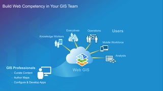
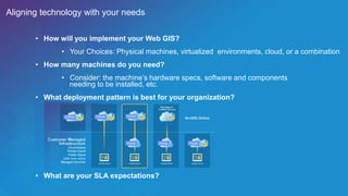
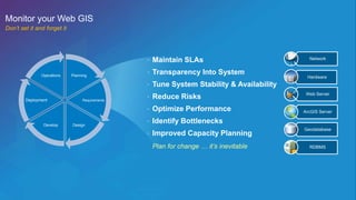
SlideShare a Scribd company logo
1 of 26
Web GIS:
Architectural Patterns and Practices
Philip Heede
Shannon Kalisky
Web Maps
Layers
Apps
Desktop
Server GIS
Web Scenes
Web GIS | Transformation of the ArcGIS Platform
Web Maps
Web Scenes
Web Layers
Apps
Users
Services
Data
Web GIS
Pervasive use of web layers, scenes, and maps
within all of the ArcGIS apps
Server GIS
Silo’d use of GIS services within custom applications
App
Services
Data
… n+1
portal
Web GIS | How is it Different from Server GIS?
Web GIS | Anatomy
Desktop Web Device
Server Online Content
and Services
portal
1. Users & Apps
2. Portal
3. GIS Server 4. Basemaps & Utility Services
Web GIS | How to get a portal
ArcGIS for Server ArcGIS Online
• Software
- Portal for ArcGIS as part of
ArcGIS for Server
- Releases 1-2 times per year
- Upgraded manually (by organization)
- Organization controls SLA
• Core Web GIS functionality
(visualization, smart mapping, analysis…)
• Enterprise Integration
- Web SSO via SAML
- Web-tier Authentication via Web
Adaptor
- Enterprise Groups
- ArcGIS Server Integration…
• Advanced GIS functionality
• SaaS
- www.arcgis.com
- Releases 3-4 times per year
- Upgraded automatically (by Esri)
- Esri controls SLA
• Core Web GIS functionality
(visualization, smart mapping, analysis…)
• Enterprise Integration
- Web SSO via SAML
• Esri-provided content and services
- Basemaps
- Living Atlas
- GeoEnrichment, Routing, …
Web GIS | Anatomy of the portal
Desktop Web Device
Server Online Content
and Services
portal
The portal in ArcGIS Online just is:
hosted by Esri and no need for installation
or maintenance nor breaking apart into
the backend components..
For a deployment using Portal for ArcGIS there are
three main components that make up a Web GIS:
Portal for ArcGIS
Hosting server
(ArcGIS Server)
ArcGIS Data Store
Web GIS | Anatomy of the portal
Portal for ArcGIS
Hosting server
(ArcGIS Server)
ArcGIS Data Store
Web GIS
components
in your own infrastructure
Supports hosted data as well
as the app and collaboration infrastructure;
does not replace Server GIS infrastructure
Server
Supports publishing of authoritative data
from enterprise geodatabases;
can be used in conjunction with a Web GIS
Server GIS infrastructure
Enterprise
geodatabase
Portal
Online Online Online
Portal Portal
Customer Managed
Infrastructure
On-premises
Private Cloud
Public Cloud
(AWS, Azure, others)
Managed Services
Begin with ArcGIS Online & SaaS
Begin with Server GIS, On-Premises
ArcGIS Online
Web GIS Deployment Patterns | Typical Evolution(s)
Basemaps &
Content Services
ArcGIS Server ArcGIS Server ArcGIS Server ArcGIS Server
Distributed Web GIS | Next Evolution in GIS
Desktop
GIS
(standalone GIS)
Server
GIS
(client-server GIS)
Web GIS
Distributed
Web GIS
Technology People
Process
Succeeding with Web GIS | Requires More Than Technology
Planning
How members engage with your Web GIS | Where do you start?
• Who can access content?
• What content can they access?
• What can users do with the content they access?
Build Web Competency in Your GIS Team
Operations
Mobile Workforce
GIS Professionals
Knowledge Workers
Executives
• Curate Content
• Author Maps
• Configure & Develop Apps
Analysts
… … …
GIS Team
Secure Executive Sponsorship
… … …
GIS Team
Location Enabled
… … …
GIS Team
Secure Executive Sponsorship
… … …
GIS Team
Location Enabled
… … …
GIS Team
Location Enabled
Secure Executive Sponsorship
Aligning technology with your needs
• How will you implement your Web GIS?
• Your Choices: Physical machines, virtualized environments, cloud, or a combination
• How many machines do you need?
• Consider: the machine’s hardware specs, software and components
needing to be installed, etc.
• What deployment pattern is best for your organization?
• What are your SLA expectations?
Partner with IT
Operations
Mobile Workforce
GIS Professionals
Knowledge Workers
Executives
Analysts
• Curate Content
• Author Maps
• Configure & Develop Apps
IT Professionals
• Ensure Business Continuity
• Apply Security
• Enforce Governance
Leverage IT to help you scale
GIS GIS
Don’t neglect your GIS infrastructure!
Operations
Mobile Workforce
GIS Professionals
Knowledge Workers
Executives
Analysts
• Curate Content
• Author Maps
• Configure & Develop Apps
IT Professionals
• Ensure Business Continuity
• Apply Security
• Enforce Governance
Know who you need at the table as you grow
Subject Matter
Experts
• Operational Data Experts
• Drive Requirements
• Power Users
Portal
Story Maps
Explorer
Collector
Office
Focused Apps
(Configured and/or Customized)
Dashboard
Think about your users …
… deliver the app(s) they need
Tackle your Mapzillas
Go After Low Hanging Fruit
Level
of
Difficulty
Narrow / Small Broad / Big
Hard
Easy
Organizational Impact
Don’t Underestimate Design
Configure first, but don’t be afraid to customize
ArcGIS Local Perspective Template
City of LA Street Wize
• Updated styling & symbology
• Tailored workflow to the user
• Tailored application to the data
Show Something New
Mobile Story Maps
3D
Integration
(MS Office,Microstrategy…)
Real Time
Planning
Requirements
Design
Develop
Deployment
Operations
• Maintain SLAs
• Transparency Into System
• Tune System Stability & Availability
• Reduce Risks
• Optimize Performance
• Identify Bottlenecks
• Improved Capacity Planning
Plan for change … it’s inevitable
Network
Hardware
Web Server
ArcGIS Server
Geodatabase
RDBMS
Monitor your Web GIS
Don’t set it and forget it
webgis architecture and practices patterns

More Related Content

Similar to webgis architecture and practices patterns

Getting Started with the ArcGIS API for JavaScript, Esri, Julie Powell, Antoo...
Getting Started with the ArcGIS API for JavaScript, Esri, Julie Powell, Antoo...Getting Started with the ArcGIS API for JavaScript, Esri, Julie Powell, Antoo...
Getting Started with the ArcGIS API for JavaScript, Esri, Julie Powell, Antoo...
Esri Nederland
 
ArcGIS for Server, Portal for ArcGIS and the Road Ahead - Esri norsk BK 2014
ArcGIS for Server, Portal for ArcGIS and the Road Ahead - Esri norsk BK 2014ArcGIS for Server, Portal for ArcGIS and the Road Ahead - Esri norsk BK 2014
ArcGIS for Server, Portal for ArcGIS and the Road Ahead - Esri norsk BK 2014
Geodata AS
 
North South GIS India
North South GIS India North South GIS India
North South GIS India
Teja Rani
 

Similar to webgis architecture and practices patterns (20)

Getting Started with the ArcGIS API for JavaScript, Esri, Julie Powell, Antoo...
Getting Started with the ArcGIS API for JavaScript, Esri, Julie Powell, Antoo...Getting Started with the ArcGIS API for JavaScript, Esri, Julie Powell, Antoo...
Getting Started with the ArcGIS API for JavaScript, Esri, Julie Powell, Antoo...
 
Esri South Africa ArcGIS 10.2 Rollout
Esri South Africa ArcGIS 10.2 Rollout Esri South Africa ArcGIS 10.2 Rollout
Esri South Africa ArcGIS 10.2 Rollout
 
ArcGIS - A Platform for Developers & Startups
ArcGIS - A Platform for Developers & StartupsArcGIS - A Platform for Developers & Startups
ArcGIS - A Platform for Developers & Startups
 
ArcGIS 10.1 for Server Functionality Matrix
ArcGIS 10.1 for Server Functionality MatrixArcGIS 10.1 for Server Functionality Matrix
ArcGIS 10.1 for Server Functionality Matrix
 
Esri WebGIS Platform
Esri WebGIS PlatformEsri WebGIS Platform
Esri WebGIS Platform
 
Esri 2016 User Conference - ArcGIS Online steps for success
Esri 2016 User Conference - ArcGIS Online steps for successEsri 2016 User Conference - ArcGIS Online steps for success
Esri 2016 User Conference - ArcGIS Online steps for success
 
Esri Scotland Conf 2016 Glasgow City Council
Esri Scotland Conf 2016   Glasgow City CouncilEsri Scotland Conf 2016   Glasgow City Council
Esri Scotland Conf 2016 Glasgow City Council
 
ArcGIS for Server, Portal for ArcGIS and the Road Ahead - Esri norsk BK 2014
ArcGIS for Server, Portal for ArcGIS and the Road Ahead - Esri norsk BK 2014ArcGIS for Server, Portal for ArcGIS and the Road Ahead - Esri norsk BK 2014
ArcGIS for Server, Portal for ArcGIS and the Road Ahead - Esri norsk BK 2014
 
Our works
Our worksOur works
Our works
 
ArcGIS Progress and Road Map - Esri Ireland Tech Update 2019
ArcGIS Progress and Road Map - Esri Ireland Tech Update 2019ArcGIS Progress and Road Map - Esri Ireland Tech Update 2019
ArcGIS Progress and Road Map - Esri Ireland Tech Update 2019
 
ArcGIS Online Lunch and Learn
ArcGIS Online Lunch and LearnArcGIS Online Lunch and Learn
ArcGIS Online Lunch and Learn
 
Utilizing Esri Out of the Box Tools for Field Data Verification
Utilizing Esri Out of the Box Tools for Field Data VerificationUtilizing Esri Out of the Box Tools for Field Data Verification
Utilizing Esri Out of the Box Tools for Field Data Verification
 
Oow2016 review--paas-microservices-
Oow2016 review--paas-microservices-Oow2016 review--paas-microservices-
Oow2016 review--paas-microservices-
 
Successful use of ArcGIS Online in Organisations - Esri norsk BK 2014
Successful use of ArcGIS Online in Organisations - Esri norsk BK 2014Successful use of ArcGIS Online in Organisations - Esri norsk BK 2014
Successful use of ArcGIS Online in Organisations - Esri norsk BK 2014
 
NDGeospatialSummit2022 - SaaS GIS for Local Government
NDGeospatialSummit2022 - SaaS GIS for Local GovernmentNDGeospatialSummit2022 - SaaS GIS for Local Government
NDGeospatialSummit2022 - SaaS GIS for Local Government
 
Adding Location and Geospatial Analytics to Big Data Analytics (BDT210) | AWS...
Adding Location and Geospatial Analytics to Big Data Analytics (BDT210) | AWS...Adding Location and Geospatial Analytics to Big Data Analytics (BDT210) | AWS...
Adding Location and Geospatial Analytics to Big Data Analytics (BDT210) | AWS...
 
North South GIS India
North South GIS India North South GIS India
North South GIS India
 
Web Based GIS
Web Based GISWeb Based GIS
Web Based GIS
 
Esriuk_track5_pro_launch
Esriuk_track5_pro_launchEsriuk_track5_pro_launch
Esriuk_track5_pro_launch
 
Jefferson Andrade - Esri Dev Summit 2016 #02 - Dev Tools
Jefferson Andrade - Esri Dev Summit 2016 #02 - Dev ToolsJefferson Andrade - Esri Dev Summit 2016 #02 - Dev Tools
Jefferson Andrade - Esri Dev Summit 2016 #02 - Dev Tools
 

Recently uploaded

Determination of Total Iodine using ICP-MS in Israeli Bottled and Tap Water: ...
Determination of Total Iodine using ICP-MS in Israeli Bottled and Tap Water: ...Determination of Total Iodine using ICP-MS in Israeli Bottled and Tap Water: ...
Determination of Total Iodine using ICP-MS in Israeli Bottled and Tap Water: ...
The Hebrew University of Jerusalem
 
Clinico-mycological profile of isolates of superficial fungal infection: A st...
Clinico-mycological profile of isolates of superficial fungal infection: A st...Clinico-mycological profile of isolates of superficial fungal infection: A st...
Clinico-mycological profile of isolates of superficial fungal infection: A st...
Open Access Research Paper
 

Recently uploaded (20)

Water Pollution
Water Pollution Water Pollution
Water Pollution
 
Determination of Total Iodine using ICP-MS in Israeli Bottled and Tap Water: ...
Determination of Total Iodine using ICP-MS in Israeli Bottled and Tap Water: ...Determination of Total Iodine using ICP-MS in Israeli Bottled and Tap Water: ...
Determination of Total Iodine using ICP-MS in Israeli Bottled and Tap Water: ...
 
Clinico-mycological profile of isolates of superficial fungal infection: A st...
Clinico-mycological profile of isolates of superficial fungal infection: A st...Clinico-mycological profile of isolates of superficial fungal infection: A st...
Clinico-mycological profile of isolates of superficial fungal infection: A st...
 
Elemental Analysis of Plants using ICP-OES(2023)
Elemental Analysis of Plants using ICP-OES(2023)Elemental Analysis of Plants using ICP-OES(2023)
Elemental Analysis of Plants using ICP-OES(2023)
 
Understanding Air Quality Monitoring A Comprehensive Guide.pdf
Understanding Air Quality Monitoring A Comprehensive Guide.pdfUnderstanding Air Quality Monitoring A Comprehensive Guide.pdf
Understanding Air Quality Monitoring A Comprehensive Guide.pdf
 
Role of nanotechnology in management of stored grain pests of cereals and pulses
Role of nanotechnology in management of stored grain pests of cereals and pulsesRole of nanotechnology in management of stored grain pests of cereals and pulses
Role of nanotechnology in management of stored grain pests of cereals and pulses
 
slidesgo-maximizing-sustainability-the-case-for-plastic-reuse
slidesgo-maximizing-sustainability-the-case-for-plastic-reuseslidesgo-maximizing-sustainability-the-case-for-plastic-reuse
slidesgo-maximizing-sustainability-the-case-for-plastic-reuse
 
❤️Ambattur Call Girls 💯Call Us 🔝 6378878445 🔝 💃 Top Class Call Girl Service A...
❤️Ambattur Call Girls 💯Call Us 🔝 6378878445 🔝 💃 Top Class Call Girl Service A...❤️Ambattur Call Girls 💯Call Us 🔝 6378878445 🔝 💃 Top Class Call Girl Service A...
❤️Ambattur Call Girls 💯Call Us 🔝 6378878445 🔝 💃 Top Class Call Girl Service A...
 
Heavy metals with their causes and effect.ppt
Heavy metals with their causes and effect.pptHeavy metals with their causes and effect.ppt
Heavy metals with their causes and effect.ppt
 
Role of Induced Systemic Resistance (ISR)In Plant Disease Management
Role of Induced Systemic Resistance (ISR)In Plant Disease ManagementRole of Induced Systemic Resistance (ISR)In Plant Disease Management
Role of Induced Systemic Resistance (ISR)In Plant Disease Management
 
Jumping Scales and Producing peripheries.pptx
Jumping Scales and Producing peripheries.pptxJumping Scales and Producing peripheries.pptx
Jumping Scales and Producing peripheries.pptx
 
ADBB 5cladba Precursor JWH018 +85244677121
ADBB 5cladba Precursor JWH018 +85244677121ADBB 5cladba Precursor JWH018 +85244677121
ADBB 5cladba Precursor JWH018 +85244677121
 
2024-05-08 Composting at Home 101 for the Rotary Club of Pinecrest.pptx
2024-05-08 Composting at Home 101 for the Rotary Club of Pinecrest.pptx2024-05-08 Composting at Home 101 for the Rotary Club of Pinecrest.pptx
2024-05-08 Composting at Home 101 for the Rotary Club of Pinecrest.pptx
 
CAUSES,EFFECTS,CONTROL OF DEFORESTATION.pptx
CAUSES,EFFECTS,CONTROL OF DEFORESTATION.pptxCAUSES,EFFECTS,CONTROL OF DEFORESTATION.pptx
CAUSES,EFFECTS,CONTROL OF DEFORESTATION.pptx
 
Urban Farming: 3 Benefits, Challenges & The Rise of Green Cities | CIO Women ...
Urban Farming: 3 Benefits, Challenges & The Rise of Green Cities | CIO Women ...Urban Farming: 3 Benefits, Challenges & The Rise of Green Cities | CIO Women ...
Urban Farming: 3 Benefits, Challenges & The Rise of Green Cities | CIO Women ...
 
Yil Me Hu Summer 2023 Edition - Nisqually Salmon Recovery Newsletter
Yil Me Hu Summer 2023 Edition - Nisqually Salmon Recovery NewsletterYil Me Hu Summer 2023 Edition - Nisqually Salmon Recovery Newsletter
Yil Me Hu Summer 2023 Edition - Nisqually Salmon Recovery Newsletter
 
Hertwich_EnvironmentalImpacts_BuildingsGRO.pptx
Hertwich_EnvironmentalImpacts_BuildingsGRO.pptxHertwich_EnvironmentalImpacts_BuildingsGRO.pptx
Hertwich_EnvironmentalImpacts_BuildingsGRO.pptx
 
Palynology: History, branches, basic principles and application, collection o...
Palynology: History, branches, basic principles and application, collection o...Palynology: History, branches, basic principles and application, collection o...
Palynology: History, branches, basic principles and application, collection o...
 
Mastering Sustainable Living: Your Comprehensive Guide to Greener Choices in ...
Mastering Sustainable Living: Your Comprehensive Guide to Greener Choices in ...Mastering Sustainable Living: Your Comprehensive Guide to Greener Choices in ...
Mastering Sustainable Living: Your Comprehensive Guide to Greener Choices in ...
 
NO1 Pakistan Black magic/kala jadu,manpasand shadi in lahore,karachi rawalpin...
NO1 Pakistan Black magic/kala jadu,manpasand shadi in lahore,karachi rawalpin...NO1 Pakistan Black magic/kala jadu,manpasand shadi in lahore,karachi rawalpin...
NO1 Pakistan Black magic/kala jadu,manpasand shadi in lahore,karachi rawalpin...
 

webgis architecture and practices patterns

  • 1. Web GIS: Architectural Patterns and Practices Philip Heede Shannon Kalisky
  • 2. Web Maps Layers Apps Desktop Server GIS Web Scenes Web GIS | Transformation of the ArcGIS Platform
  • 3. Web Maps Web Scenes Web Layers Apps Users Services Data Web GIS Pervasive use of web layers, scenes, and maps within all of the ArcGIS apps Server GIS Silo’d use of GIS services within custom applications App Services Data … n+1 portal Web GIS | How is it Different from Server GIS?
  • 4. Web GIS | Anatomy Desktop Web Device Server Online Content and Services portal 1. Users & Apps 2. Portal 3. GIS Server 4. Basemaps & Utility Services
  • 5. Web GIS | How to get a portal ArcGIS for Server ArcGIS Online • Software - Portal for ArcGIS as part of ArcGIS for Server - Releases 1-2 times per year - Upgraded manually (by organization) - Organization controls SLA • Core Web GIS functionality (visualization, smart mapping, analysis…) • Enterprise Integration - Web SSO via SAML - Web-tier Authentication via Web Adaptor - Enterprise Groups - ArcGIS Server Integration… • Advanced GIS functionality • SaaS - www.arcgis.com - Releases 3-4 times per year - Upgraded automatically (by Esri) - Esri controls SLA • Core Web GIS functionality (visualization, smart mapping, analysis…) • Enterprise Integration - Web SSO via SAML • Esri-provided content and services - Basemaps - Living Atlas - GeoEnrichment, Routing, …
  • 6. Web GIS | Anatomy of the portal Desktop Web Device Server Online Content and Services portal The portal in ArcGIS Online just is: hosted by Esri and no need for installation or maintenance nor breaking apart into the backend components.. For a deployment using Portal for ArcGIS there are three main components that make up a Web GIS: Portal for ArcGIS Hosting server (ArcGIS Server) ArcGIS Data Store
  • 7. Web GIS | Anatomy of the portal Portal for ArcGIS Hosting server (ArcGIS Server) ArcGIS Data Store Web GIS components in your own infrastructure Supports hosted data as well as the app and collaboration infrastructure; does not replace Server GIS infrastructure Server Supports publishing of authoritative data from enterprise geodatabases; can be used in conjunction with a Web GIS Server GIS infrastructure Enterprise geodatabase
  • 8. Portal Online Online Online Portal Portal Customer Managed Infrastructure On-premises Private Cloud Public Cloud (AWS, Azure, others) Managed Services Begin with ArcGIS Online & SaaS Begin with Server GIS, On-Premises ArcGIS Online Web GIS Deployment Patterns | Typical Evolution(s) Basemaps & Content Services ArcGIS Server ArcGIS Server ArcGIS Server ArcGIS Server
  • 9. Distributed Web GIS | Next Evolution in GIS Desktop GIS (standalone GIS) Server GIS (client-server GIS) Web GIS Distributed Web GIS
  • 10. Technology People Process Succeeding with Web GIS | Requires More Than Technology Planning
  • 11. How members engage with your Web GIS | Where do you start? • Who can access content? • What content can they access? • What can users do with the content they access?
  • 12. Build Web Competency in Your GIS Team Operations Mobile Workforce GIS Professionals Knowledge Workers Executives • Curate Content • Author Maps • Configure & Develop Apps Analysts
  • 13. … … … GIS Team Secure Executive Sponsorship
  • 14. … … … GIS Team Location Enabled … … … GIS Team Secure Executive Sponsorship
  • 15. … … … GIS Team Location Enabled … … … GIS Team Location Enabled Secure Executive Sponsorship
  • 16. Aligning technology with your needs • How will you implement your Web GIS? • Your Choices: Physical machines, virtualized environments, cloud, or a combination • How many machines do you need? • Consider: the machine’s hardware specs, software and components needing to be installed, etc. • What deployment pattern is best for your organization? • What are your SLA expectations?
  • 17. Partner with IT Operations Mobile Workforce GIS Professionals Knowledge Workers Executives Analysts • Curate Content • Author Maps • Configure & Develop Apps IT Professionals • Ensure Business Continuity • Apply Security • Enforce Governance
  • 18. Leverage IT to help you scale GIS GIS Don’t neglect your GIS infrastructure!
  • 19. Operations Mobile Workforce GIS Professionals Knowledge Workers Executives Analysts • Curate Content • Author Maps • Configure & Develop Apps IT Professionals • Ensure Business Continuity • Apply Security • Enforce Governance Know who you need at the table as you grow Subject Matter Experts • Operational Data Experts • Drive Requirements • Power Users
  • 20. Portal Story Maps Explorer Collector Office Focused Apps (Configured and/or Customized) Dashboard Think about your users … … deliver the app(s) they need Tackle your Mapzillas
  • 21. Go After Low Hanging Fruit Level of Difficulty Narrow / Small Broad / Big Hard Easy Organizational Impact
  • 23. Configure first, but don’t be afraid to customize ArcGIS Local Perspective Template City of LA Street Wize • Updated styling & symbology • Tailored workflow to the user • Tailored application to the data
  • 24. Show Something New Mobile Story Maps 3D Integration (MS Office,Microstrategy…) Real Time
  • 25. Planning Requirements Design Develop Deployment Operations • Maintain SLAs • Transparency Into System • Tune System Stability & Availability • Reduce Risks • Optimize Performance • Identify Bottlenecks • Improved Capacity Planning Plan for change … it’s inevitable Network Hardware Web Server ArcGIS Server Geodatabase RDBMS Monitor your Web GIS Don’t set it and forget it