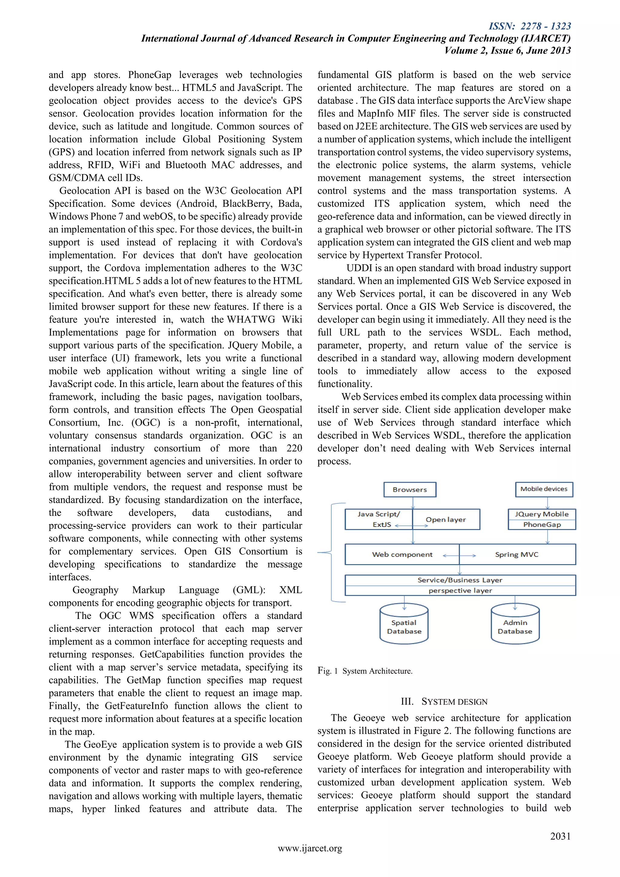
This document discusses a system architecture for web service based GIS. The system is designed to provide hosted spatial data and GIS functionality through web services to allow for integration with various customized application systems. The web services can be used to perform basic geo-processing tasks like address matching, map display, and routing without needing to maintain the underlying geographical data. The system implements open standards like WMS, WFS, and GML. It has a multi-layer architecture with interfaces for web services, servlets/JSPs, and GIS APIs built on a J2EE framework. The system provides a distributed platform for sharing geospatial information to support applications like transportation planning.
![ISSN: 2278 - 1323
International Journal of Advanced Research in Computer Engineering and Technology (IJARCET)
Volume 2, Issue 6, June 2013
www.ijarcet.org
2030
Abstract— The Geoeye web services provide a new efficient
solution to assemble the GIS functions into a variety of
applications. This paper presents the system architecture design
for web service based GIS. The GIS web services are designed to
provide the hosted spatial data and GIS functionality for the
different customized application systems to perform basic
Geo-processing tasks, such as address matching, map image
display, and routing. It also supports the complex rendering,
navigation and allows working with multiple layers, thematic
maps, hyper linked features and attribute data. It has an
important application prospect in the urban development.
Index Terms— Geolocation, urban development, Postgres, Web
Service,
I. INTRODUCTION
The Geoeye project is self-contained, self-describing,
modular application that can be published, located, and
dynamically invoked across the web [1].It is an indispensable
tool for analyzing and managing spatial data. Basically
Geoeye is used to provide user with spatial information. In the
case of the traditional GIS these type of information was
within an organization or group of organization. Thus the
information provided by GIS was restricted within a
boundary. While the traditional GIS software development
method would be very difficult to meet the needs for all the
subsystems of Transportation Systems with single GIS
platform, the GIS web service technologies have provided a
new efficient solution for all those ITS application systems.
The Geoeye web services are the software components that
can provide the hosted spatial data and GIS functionalities
that can be accessed and integrated to the different practical
customized urban development applications. Developers can
apply the Geoeye web services to perform geographical
information processing and return the results to the
customized applications without maintaining the basic
geographical data. The web service technology is a very
promising architecture for practical implementation of the
Web-GIS based urban development application system.
It will also have a spatial reference to actual site of work. Web
client will allow its users to search for projects and refer on
map the site of work. All project related documents can be
tagged against the project and project work status can be
updated very easily through this application. It will also allow
generating project specific reports.
Using Geoeye mobile client application user can easily get the
current location and the progressive report of particular
Manuscript received June, 2013.
Ambika patil, CSE, v.t.u/ Dr.A.I.T Bangalore, Bangalore, India,
919740811226
project in a time and it will give the visual representation of
images which is related to the project using these application
management can make their decisions. This tool can help
conduct surveillance, monitor people and situations on the
ground, respond to emergencies. Implementing these
applications in one municipality can be expensive,
particularly in today’s climate of scarce funding. As a result,
many communities look for ways to share data easily and
quickly across regional borders. Geoeye supports this
data-sharing model by collecting imagery over wide areas as
quickly as possible. Additionally, our product-licensing
systems facilitate information-sharing among regional’s. The
objective of the proposal is to strengthen the functioning of
Audit Status Monitoring and make them effective and better.
The entire scope has been classified into five streams knows
as Coordinator Level, management Level, Auditor Level,
User Level and State Web Coordinator Level.
II. LITERATURE SURVEY
Web Services are the software components that are well
defined, self-contained, and does not depend on the context or
state of other services. Web services essentially use XML to
create a robust connection. Web Services Technologies
include the WSDL (Web Services Description Language) for
service description, UDDI (Universal Description, Discovery
and Integration) for service discovery, SOAP (Simple Object
Access Protocol) for passing XML-encoded data. The web
services use SOAP, WSDL, UDDI, and WSIL (Web Services
Inspection Language) to communicate. Web services are
published on the UDDI registry. A WSDL document defines
the target service so the client knows what the service does.
SOAP standardizes the way a Web service communicates
with a client and allows programs written in different
languages and on different platforms to communicate.
PostgreSQL, often simply Postgres, is an object-relational
database management system (ORDBMS) available
platforms including Linux, FreeBSD, Solaris, Microsoft
Windows and Mac OS X. PostgreSQL is developed by the
PostgreSQL Global Development Group, consisting of a
handful of volunteers employed and supervised by companies
such as Red Hat and Enterprise DB [2, 4]. It implements the
majority of the SQL : 2008 standard, is ACID-compliant, is
fully transactional (including all DDL statements), has
extensible data types, operators, index methods, functions,
aggregates, procedural languages, and has a large number of
extensions written by third parties. The vast majority of Linux
distributions have PostgreSQL available in supplied
packages. Mac OS X, starting with Lion, has PostgreSQL
server as its standard default database in the server edition,
and PostgreSQL client tools in the desktop edition. PhoneGap
is an HTML5 app platform that allows you to author native
applications with web technologies and get access to APIs
GEOEYE
Ambika Patil](https://image.slidesharecdn.com/volume-2-issue-6-2030-2033-130822073932-phpapp01/75/Volume-2-issue-6-2030-2033-1-2048.jpg)
![ISSN: 2278 - 1323
International Journal of Advanced Research in Computer Engineering and Technology (IJARCET)
Volume 2, Issue 6, June 2013
2033
www.ijarcet.org
system, every one participates in the activities to cooperate,
broadcast the data of transportation planning through GIS
web service.
(4) Transportation planning department, Traffic department,
relevant government department, and public cooperation: The
system can synchronize transportation planning department,
traffic department, relevant government department, and
public through the center databases. The GIS,
transportation-planning project, and CSCW information can
be shared and exchanged.
The system can provide an efficient means for the
transportation planning with following advantages. Firstly,
the hosted spatial data and GIS functionalities that can be
accessed and integrated to the different customized GIS
applications to meet the practical need in the processes of
transportation planning. Secondly, running on the Internet,
the system is accessible from anywhere in the world.
Web-GIS service technologies not only make the system
broadly accessible through Internet and but also provide the
precise geo-referenced data for public and transportation
planning researchers.
V. CONCLUSIONS
This paper presents the system architecture design for
web service based GIS. It includes the GIS functions and the
geo-referenced cooperating work and information sharing
depend on the spatial data web service. The organizations
could use the Geoeye web services to work together. It
provides the basic functions in coordination working
environment. Through Geoeye web service, the hosted spatial
data and GIS functionalities that can be accessed and
integrated to the different customized applications. The
service-oriented architecture is a very promising architecture
for practical implementation of the next generation GIS
information systems. It has an important application prospect
in the urban development and application. Further work will
be performed to establish the common GIS Web services that
can be easily used and integrated in different ITS application
systems.
ACKNOWLEDGMENT
Skygroup Bangalore; MapInfinity organisation Bangalore;
Technical head of Mapinfinity, Faculty of Dr. A.I.T,
are greatly acknowledged.
References
[1] IBM, “Web Services architecture overview”,
Availableat http://www-106.ibm.com/developerworks/
webservices/ library/ w-ovr/. 2003.”, ESRI Press,
2003.
[2] Lu Jingge,Yang Yongguo,WebGIS server based on
open source software to build[J]. GEOMATICS &
SPATIAL INFORMATION TECHNOLOGY,
2008,31(5):pp.145-147.
[3] Domenico Cotroneo, Cristiano di Flora and Stefano
Russo, “An Enhanced Service Oriented Architecture
for Developing Web-based Applications”, J. Web
Eng., 1(2), pp. 128~146, 2003.
[4] Gui Lan, Li Yaojun, Chen Xinfa, “Study and
Development of WebGIS-T for Transportation”,
Journal of Changsha Communications University,
Vol.17 No.4, pp.18-22, 2001.
[5] Y. Shanzhen, Z. Lizhu, X. Chunxiao, L. Qilun, and Z.
Yong,“Semantic and Interoperable WebGIS”,
International Conference on Web Information Systems
Engineering (WISE'01), Vol.2, Kyoto, Japan, pp.
42-48, December 03 - 06, 2001.
[6] PostGIS Website. http://postgis.refractions.net/
(Accessed April 16, 2009).
Ambika patil received the B.E. degree in Information
Science & Engineering in 2007,
Pursuing M. Tech in computer science and engineering in Dr.
A.I.T college Bangalore .I have worked as Associate
Professor in Rural engineering Bhalki , Bidar.](https://image.slidesharecdn.com/volume-2-issue-6-2030-2033-130822073932-phpapp01/75/Volume-2-issue-6-2030-2033-4-2048.jpg)