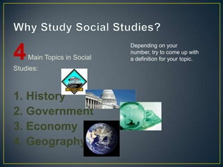
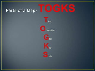
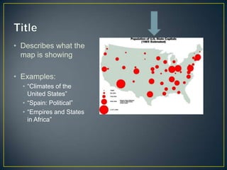
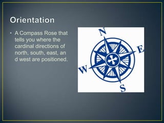
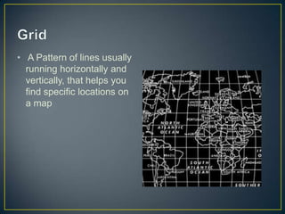
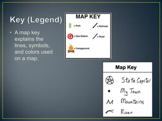
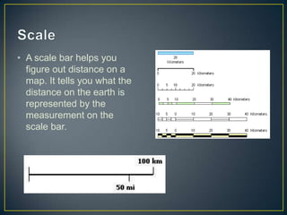
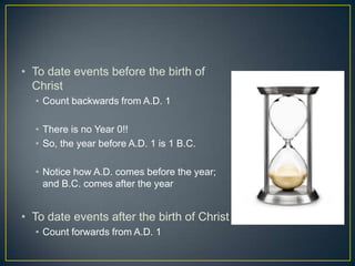
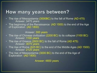
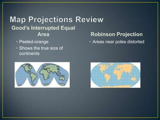
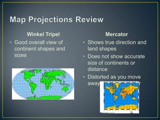
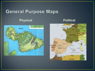
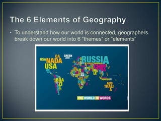
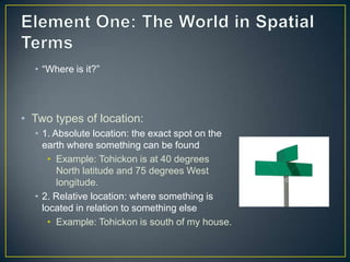
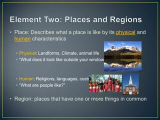
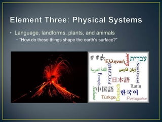
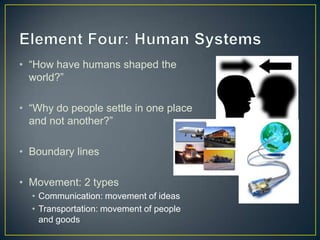
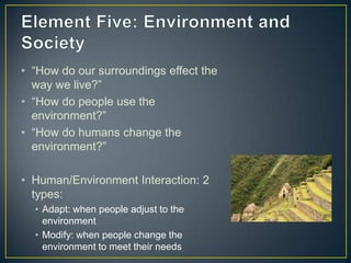
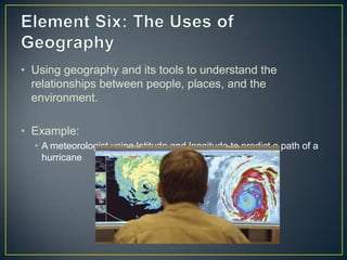
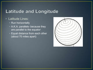
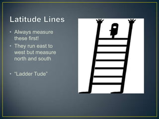
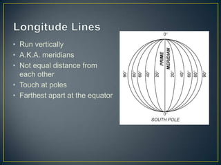
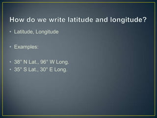
This document provides an overview of key concepts in social studies, including the four main topics (history, government, economy, and geography), how to read and understand maps, and the six elements of geography. It explains why we study social studies and defines the four main topics. It also describes the parts of a map, how to measure time by B.C. and A.D. dates, different map projections, and the six elements of geography that break down the world spatially and in terms of places, physical systems, human systems, environment/society, and the uses of geography. Finally, it discusses latitude and longitude, how they are written, and their purpose in locating absolute and relative places on Earth.
What is Geography, Branches of Geography and Scope of Geography.Muhammad Saad
The basic purpose of this ppt Presentation is to understand the following main topics of geography in detail.
1. DEFINITION OF GEOGRAPHY
2. TWO MAIN BRANCHES OF GEOGRAPHY:
(PHYSICAL || HUMAN)
3. SUB-BRANCHES OF GEOGRAPHY
4. SCOPE OF GEOGRAPHY
(MATERIAL || FIELD)
..........That's all......Thank you.
Physical Geography Lecture 01 - What Is Geography 092616angelaorr
Introduction to Physical Geography. What is Geography? 5 Fundamental spatial concepts of Geography. Geography is holistic. Subdivisions of Geography. Systems science. Earth's 4 spheres. Review.
Data analysis in geography simply concerns the methodology for collecting, analyzing, and presenting data. It frequently involves the application of statistical techniques useful in several ways ― first, these help summarize the findings of studies (example: total rainfall during a period in a state), second, these help understanding of the phenomenon under study (example: rainfall is more in the southern districts), third, these help forecast the state of variables (example: draught is likely during the next year), fourth, these help evaluate performance of certain activity (example: more rainfall means more rice production), fifth, these help decision making (example: finding out the best location for a H.S. School), sixth, they also help to establish whether relationships between the characteristics of a set of observations are genuine or not, and finally, certainly all these can show that the results of the analysis make a valuable contribution to the body of geographical knowledge.
Statistical techniques and procedures are applied in all fields of academic research; wherever data are collected and summarized or wherever any numerical information is analyzed or research is conducted, statistics are needed for sound analysis and interpretation of results. Geographers primarily use statistics in the following ways: to describe and summarize spatial data, to make generalizations concerning complex spatial patterns, to estimate the probability of outcomes for an event at a given location, to use samples of geographic data to infer characteristics for a larger set of geographic data (population), to determine if the magnitude or frequency of some phenomenon differs from one location to another, and to learn whether an actual spatial pattern matches some expected pattern.
AP Human Geography: Unit 1 - Introduction to GeographyDaniel Eiland
Here is the Advanced Placement Human Geography Unit1 Powerpoint I will be using to teach my classes this year. It includes the sections "Introduction to Geography", "Tools Geographers Use", and "The Five Themes of Geography". You can find the guided notes for this presentation here: http://www.slideshare.net/deilands/ap-human-geography-unit-1-13583828
Role of Remote Sensing(RS) and Geographical Information System (GIS) in Geogr...Prof Ashis Sarkar
since1970s, there has been a sharp rise in Global Resource Information System (gris) facilitated by satellites/satellite-aided geodetic, cartographic and geostatistical methods. This enormous information base needs an entirely new methods of analysis and interpretation. Hence, emerged an entirely new branch of learning and methodology, “geoinformatics”.
An introduction to the study of World Geography.
a) meaning of geography
b) essential elements of geography
c) branches of geography
d) themes of geography
e) graphic representation of the Earth (maps)
f) the global grid system
g) types of maps
h) map essentials
i) earth as a member of the solar system
j) the Planet Earth
k) evaluation (Quiz)
What is Geophagy?
Themes of Geography
Traditions of Geography
Tools of Geography.
• MAPS
• ATLAS
• GLOBE
• AERIAL PHOTOGRAPHS
• SATELLITE PHOTOGRAPHS
• INFORMATION GRAPHICS
• GEOGRAPHIC INFORMATION SYSTEM
We all have good and bad thoughts from time to time and situation to situation. We are bombarded daily with spiraling thoughts(both negative and positive) creating all-consuming feel , making us difficult to manage with associated suffering. Good thoughts are like our Mob Signal (Positive thought) amidst noise(negative thought) in the atmosphere. Negative thoughts like noise outweigh positive thoughts. These thoughts often create unwanted confusion, trouble, stress and frustration in our mind as well as chaos in our physical world. Negative thoughts are also known as “distorted thinking”.
The Indian economy is classified into different sectors to simplify the analysis and understanding of economic activities. For Class 10, it's essential to grasp the sectors of the Indian economy, understand their characteristics, and recognize their importance. This guide will provide detailed notes on the Sectors of the Indian Economy Class 10, using specific long-tail keywords to enhance comprehension.
For more information, visit-www.vavaclasses.com
Students, digital devices and success - Andreas Schleicher - 27 May 2024..pptxEduSkills OECD
Andreas Schleicher presents at the OECD webinar ‘Digital devices in schools: detrimental distraction or secret to success?’ on 27 May 2024. The presentation was based on findings from PISA 2022 results and the webinar helped launch the PISA in Focus ‘Managing screen time: How to protect and equip students against distraction’ https://www.oecd-ilibrary.org/education/managing-screen-time_7c225af4-en and the OECD Education Policy Perspective ‘Students, digital devices and success’ can be found here - https://oe.cd/il/5yV
How to Split Bills in the Odoo 17 POS ModuleCeline George
Bills have a main role in point of sale procedure. It will help to track sales, handling payments and giving receipts to customers. Bill splitting also has an important role in POS. For example, If some friends come together for dinner and if they want to divide the bill then it is possible by POS bill splitting. This slide will show how to split bills in odoo 17 POS.
How to Make a Field invisible in Odoo 17Celine George
It is possible to hide or invisible some fields in odoo. Commonly using “invisible” attribute in the field definition to invisible the fields. This slide will show how to make a field invisible in odoo 17.
The Art Pastor's Guide to Sabbath | Steve ThomasonSteve Thomason
What is the purpose of the Sabbath Law in the Torah. It is interesting to compare how the context of the law shifts from Exodus to Deuteronomy. Who gets to rest, and why?
Synthetic Fiber Construction in lab .pptxPavel ( NSTU)
Synthetic fiber production is a fascinating and complex field that blends chemistry, engineering, and environmental science. By understanding these aspects, students can gain a comprehensive view of synthetic fiber production, its impact on society and the environment, and the potential for future innovations. Synthetic fibers play a crucial role in modern society, impacting various aspects of daily life, industry, and the environment. ynthetic fibers are integral to modern life, offering a range of benefits from cost-effectiveness and versatility to innovative applications and performance characteristics. While they pose environmental challenges, ongoing research and development aim to create more sustainable and eco-friendly alternatives. Understanding the importance of synthetic fibers helps in appreciating their role in the economy, industry, and daily life, while also emphasizing the need for sustainable practices and innovation.
How to Create Map Views in the Odoo 17 ERPCeline George
The map views are useful for providing a geographical representation of data. They allow users to visualize and analyze the data in a more intuitive manner.
3. Why Study Social Studies? 4 Main Topics in Social Studies: 1. History 2. Government 3. Economy 4. Geography Depending on your number, try to come up with a definition for your topic.
4. Parts of a Map- TOGKS Title Orientation Grid Key Scale
5. Title Describes what the map is showing Examples: “Climates of the United States” “Spain: Political” “Empires and States in Africa”
6. Orientation A Compass Rose that tells you where the cardinal directions of north, south, east, and west are positioned.
7. Grid A Pattern of lines usually running horizontally and vertically, that helps you find specific locations on a map
8. Key (Legend) A map key explains the lines, symbols, and colors used on a map.
9. Scale A scale bar helps you figure out distance on a map. It tells you what the distance on the earth is represented by the measurement on the scale bar.
10. Measuring Time Historians rely on calendars and the dating of events to measure time B.C.= Before Christ Treat like negative numbers A.D.= Anno Domini, Latin for “ in the year of our Lord” Like positive numbers
11. To date events before the birth of Christ Count backwards from A.D. 1 There is no Year 0!! So, the year before A.D. 1 is 1 B.C. Notice how A.D. comes before the year; and B.C. comes after the year To date events after the birth of Christ Count forwards from A.D. 1
12. How many years between? The rise of Mesopotamia (3000BC) to the fall of Rome (AD 475) Answer: 3475 years The beginning of the Renaissance (AD 1500) to the end of the Age of Exploration (AD 1800) Answer: 300 years The rise of Chinese civilization (2200 BC) to its collapse (1100 BC) Answer: 1100 years The rise of Greece (2600 BC) to the fall of Rome (AD 475)Answer: 3075 years The rise of Rome (625 BC) tothe end of the Middle Ages (AD 1500) Answer: 2125 years The rise of Mesopotamia (3000 BC) to the end of the Age of Exploration (AD 1800)Answer: 4800 years
13. Map Projections Review Good’s Interrupted Equal Area Peeled-orange Shows the true size of continents Robinson Projection Areas near poles distorted
14. Map Projections Review WinkelTripel Good overall view of continent shapes and sizes Mercator Shows true direction and land shapes Does not show accurate size of continents or distance Distorted as you move away from the equator
16. The 6 Elements of Geography To understand how our world is connected, geographers break down our world into 6 “themes” or “elements”
17. Element One: The World in Spatial Terms “Where is it?” Two types of location: 1. Absolute location: the exact spot on the earth where something can be found Example: Tohickon is at 40 degrees North latitude and 75 degrees West longitude. 2. Relative location: where something is located in relation to something else Example: Tohickon is south of my house.
18. Element Two: Places and Regions Place: Describes what a place is like by its physical and human characteristics Physical: Landforms, Climate, animal life “What does it look like outside your window?” Human: Religions, languages, customs “What are people like?” Region: places that have one or more things in common
19. Element Three: Physical Systems Language, landforms, plants, and animals “How do these things shape the earth’s surface?”
20. Element Four: Human Systems “How have humans shaped the world?” “Why do people settle in one place and not another?” Boundary lines Movement: 2 types Communication: movement of ideas Transportation: movement of people and goods
21. Element Five: Environment and Society “How do our surroundings effect the way we live?” “How do people use the environment?” “How do humans change the environment?” Human/Environment Interaction: 2 types: Adapt: when people adjust to the environment Modify: when people change the environment to meet their needs
22. Element Six: The Uses of Geography Using geography and its tools to understand the relationships between people, places, and the environment. Example: A meteorologist using latitude and longitude to predict a path of a hurricane
23. Latitude and Longitude Latitude Lines: Run horizontally A.K.A. parallels- because they are parallel to the equator Equal distance from each other (about 70 miles apart)
24. Latitude Lines Always measure these first! They run east to west but measure north and south “Ladder Tude”
25. Longitude Lines Run vertically A.K.A. meridians Not equal distance from each other Touch at poles Farthest apart at the equator
26. How do we write latitude and longitude? Latitude, Longitude Examples: 38° N Lat., 96° W Long. 35° S Lat., 30° E Long.