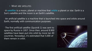
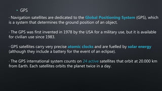
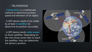
UNIT 1
COMMUNICATION
TECHNOLOGIES
TECHNOLOGIES, PROGRAMMING AND ROBOTICS
3 ESO
INDEX
• MOBILE PHONES
• RADIO
• SATELLITES AND POSITIONING SYSTEMS
• TELEVISION
• THE INTERNET
• NEGATIVE EFFECTS OF COMMUNICATION TECHNOLOGIES
3. SATELLITES AND POSITIONING SYSTEMS
• WHAT ARE SATELLITES
· A satellite is a moon, planet or machine that orbits a planet or star. Earth is a
Sun’s satellite and the moon is an Earth’s satellite.
· An artificial satellite is a machine that is launched into space and orbits around
Earth, normally with communication purposes.
· The first artificial satellite (Sputnik 1) was sent to
space by Russia in 1957. Since then, around 8.900
satellites have been put into orbit by more tan 40
countries. Nowadays, it’s estimated that 5.000 of
them remain in orbit.
• FUNCTIONS OF SATELLITES
· Weather satellites send information about cloud patterns, rain, wind speed and
temperature, which help meteorologists to forecast the weather.
· Telecommunication satellites transfer signals from one point on the Globe to
another. They handle telephone signals, ship-to-shore radio and TV and radio
signals. They are syncronised with Earth’s turning speed so they are always
orbiting over the same spot. This is known as a geostationary satellite.
· Exploration satellites are equipped with cameras to capture still and video
pictures of the planet. They can also have infrared cameras that collect heat and
cold patterns. These satellites help scientists observe changes in remote places,
like the polar ice caps. They are also used for mapping.
· Scientific satellites were astronauts travel to investigate, like te International
Space Station.
· Navigation satellites (detailed soon).
• DISTANCES BETWEEN SATELLITES AND THE EARTH
Use Exploration
Scientific
Navigation Telecommun
ication
Weather
NOTE: Planes fly at
maximum 14 km
distance from Earth
· Navigation satellites are dedicated to the Global Positioning System (GPS), which
is a system that determines the ground position of an object.
· The GPS was first invented in 1978 by the USA for a military use, but it is available
for civilian use since 1983.
· GPS satellites carry very precise atomic clocks and are fuelled by solar energy
(although they include a battery for the event of an eclipse).
· The GPS international system counts on 24 active satellites that orbit at 20.000 km
from Earth. Each satellites orbits the planet twice in a day.
• GPS
· Trilateration is a mathematic
method to determine position,
speed and elevation of an object.
· A GPS device needs to be visible
by at least 3 satellites to
determine its position accurately.
· A GPS device sends radio waves
to those satellites. Depending on
the time those waves take to reach
the satellites, they can determine
the device’s position.
• TRILATERATION

Unit 1. chapter 3. presentation satellites

  • 1.
  • 2.
    INDEX • MOBILE PHONES •RADIO • SATELLITES AND POSITIONING SYSTEMS • TELEVISION • THE INTERNET • NEGATIVE EFFECTS OF COMMUNICATION TECHNOLOGIES
  • 3.
    3. SATELLITES ANDPOSITIONING SYSTEMS
  • 4.
    • WHAT ARESATELLITES · A satellite is a moon, planet or machine that orbits a planet or star. Earth is a Sun’s satellite and the moon is an Earth’s satellite. · An artificial satellite is a machine that is launched into space and orbits around Earth, normally with communication purposes. · The first artificial satellite (Sputnik 1) was sent to space by Russia in 1957. Since then, around 8.900 satellites have been put into orbit by more tan 40 countries. Nowadays, it’s estimated that 5.000 of them remain in orbit.
  • 5.
    • FUNCTIONS OFSATELLITES · Weather satellites send information about cloud patterns, rain, wind speed and temperature, which help meteorologists to forecast the weather. · Telecommunication satellites transfer signals from one point on the Globe to another. They handle telephone signals, ship-to-shore radio and TV and radio signals. They are syncronised with Earth’s turning speed so they are always orbiting over the same spot. This is known as a geostationary satellite. · Exploration satellites are equipped with cameras to capture still and video pictures of the planet. They can also have infrared cameras that collect heat and cold patterns. These satellites help scientists observe changes in remote places, like the polar ice caps. They are also used for mapping. · Scientific satellites were astronauts travel to investigate, like te International Space Station. · Navigation satellites (detailed soon).
  • 6.
    • DISTANCES BETWEENSATELLITES AND THE EARTH Use Exploration Scientific Navigation Telecommun ication Weather NOTE: Planes fly at maximum 14 km distance from Earth
  • 7.
    · Navigation satellitesare dedicated to the Global Positioning System (GPS), which is a system that determines the ground position of an object. · The GPS was first invented in 1978 by the USA for a military use, but it is available for civilian use since 1983. · GPS satellites carry very precise atomic clocks and are fuelled by solar energy (although they include a battery for the event of an eclipse). · The GPS international system counts on 24 active satellites that orbit at 20.000 km from Earth. Each satellites orbits the planet twice in a day. • GPS
  • 8.
    · Trilateration isa mathematic method to determine position, speed and elevation of an object. · A GPS device needs to be visible by at least 3 satellites to determine its position accurately. · A GPS device sends radio waves to those satellites. Depending on the time those waves take to reach the satellites, they can determine the device’s position. • TRILATERATION