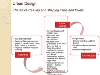
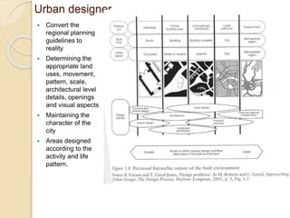
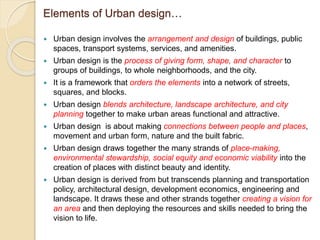
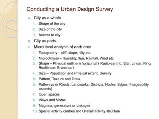
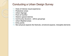
Urban design involves arranging and designing buildings, public spaces, transportation systems, and amenities to give form and character to neighborhoods and cities. It blends architecture, landscape design, and urban planning. The goal is to make urban areas functional yet attractive by connecting people and places through movement, urban form, and the built and natural environments. Urban design draws together many factors like placemaking, sustainability, equity, and economic viability. It creates a vision for an area and deploys resources to implement that vision. Conducting a thorough urban design survey analyzes both physical and non-physical elements at multiple scales from the whole city down to micro-level areas.
Urban Landscape Elements slides for Sustainable Urban Landscape Design course.
Master Sustainable Urban Design, Razak Faculty, Universiti Teknologi Malaysia.
Urban design is concerned with the arrangement, appearance and function of our suburbs, towns and cities. It is both a process and an outcome of creating localities in which people live, engage with each other, and engage with the physical place around them.
Kevyn introduced a concept of planning that was the base for understanding and visualising The Planning Aspects; important for the budding planners.
The presentation initiates the same understanding and invokes a means for better understanding of 'Planning'.
A presentation about urban design and community Architecture. This presentation is all about an introduction about the coursework urban design in the community.
Opting for Town Planning- as a career Option.pptxJIT KUMAR GUPTA
Town planning as a profession has great value in making cities and human settlements more qualitative, sustainable, livable, productive . Town planning is the only profession which deals holistically and comprehensively with the entire gamut of planning, development and management of human settlements. If this world is to be made more livable, qualitative and promoting the welfare of communities, environment. ecology, there exists no option but to go for town planning profession. Unfortunately role, importance and relevance of planning profession has not been understood, appreciated and the profession remains diluted and muted. It is time ripe enough to relook at the positivity of the profession and take it forward with commitment and sincerity, on the part of profession and professional planners. Profession needs to be revisited, reviewed and redefined to make it more rational, relevant and productive. PPT focuses on the entire gamut of planning profession as an career option.
Immunizing Image Classifiers Against Localized Adversary Attacksgerogepatton
This paper addresses the vulnerability of deep learning models, particularly convolutional neural networks
(CNN)s, to adversarial attacks and presents a proactive training technique designed to counter them. We
introduce a novel volumization algorithm, which transforms 2D images into 3D volumetric representations.
When combined with 3D convolution and deep curriculum learning optimization (CLO), itsignificantly improves
the immunity of models against localized universal attacks by up to 40%. We evaluate our proposed approach
using contemporary CNN architectures and the modified Canadian Institute for Advanced Research (CIFAR-10
and CIFAR-100) and ImageNet Large Scale Visual Recognition Challenge (ILSVRC12) datasets, showcasing
accuracy improvements over previous techniques. The results indicate that the combination of the volumetric
input and curriculum learning holds significant promise for mitigating adversarial attacks without necessitating
adversary training.
Final project report on grocery store management system..pdfKamal Acharya
In today’s fast-changing business environment, it’s extremely important to be able to respond to client needs in the most effective and timely manner. If your customers wish to see your business online and have instant access to your products or services.
Online Grocery Store is an e-commerce website, which retails various grocery products. This project allows viewing various products available enables registered users to purchase desired products instantly using Paytm, UPI payment processor (Instant Pay) and also can place order by using Cash on Delivery (Pay Later) option. This project provides an easy access to Administrators and Managers to view orders placed using Pay Later and Instant Pay options.
In order to develop an e-commerce website, a number of Technologies must be studied and understood. These include multi-tiered architecture, server and client-side scripting techniques, implementation technologies, programming language (such as PHP, HTML, CSS, JavaScript) and MySQL relational databases. This is a project with the objective to develop a basic website where a consumer is provided with a shopping cart website and also to know about the technologies used to develop such a website.
This document will discuss each of the underlying technologies to create and implement an e- commerce website.
Sachpazis:Terzaghi Bearing Capacity Estimation in simple terms with Calculati...Dr.Costas Sachpazis
Terzaghi's soil bearing capacity theory, developed by Karl Terzaghi, is a fundamental principle in geotechnical engineering used to determine the bearing capacity of shallow foundations. This theory provides a method to calculate the ultimate bearing capacity of soil, which is the maximum load per unit area that the soil can support without undergoing shear failure. The Calculation HTML Code included.
Water scarcity is the lack of fresh water resources to meet the standard water demand. There are two type of water scarcity. One is physical. The other is economic water scarcity.
Overview of the fundamental roles in Hydropower generation and the components involved in wider Electrical Engineering.
This paper presents the design and construction of hydroelectric dams from the hydrologist’s survey of the valley before construction, all aspects and involved disciplines, fluid dynamics, structural engineering, generation and mains frequency regulation to the very transmission of power through the network in the United Kingdom.
Author: Robbie Edward Sayers
Collaborators and co editors: Charlie Sims and Connor Healey.
(C) 2024 Robbie E. Sayers
Student information management system project report ii.pdfKamal Acharya
Our project explains about the student management. This project mainly explains the various actions related to student details. This project shows some ease in adding, editing and deleting the student details. It also provides a less time consuming process for viewing, adding, editing and deleting the marks of the students.
Hybrid optimization of pumped hydro system and solar- Engr. Abdul-Azeez.pdffxintegritypublishin
Advancements in technology unveil a myriad of electrical and electronic breakthroughs geared towards efficiently harnessing limited resources to meet human energy demands. The optimization of hybrid solar PV panels and pumped hydro energy supply systems plays a pivotal role in utilizing natural resources effectively. This initiative not only benefits humanity but also fosters environmental sustainability. The study investigated the design optimization of these hybrid systems, focusing on understanding solar radiation patterns, identifying geographical influences on solar radiation, formulating a mathematical model for system optimization, and determining the optimal configuration of PV panels and pumped hydro storage. Through a comparative analysis approach and eight weeks of data collection, the study addressed key research questions related to solar radiation patterns and optimal system design. The findings highlighted regions with heightened solar radiation levels, showcasing substantial potential for power generation and emphasizing the system's efficiency. Optimizing system design significantly boosted power generation, promoted renewable energy utilization, and enhanced energy storage capacity. The study underscored the benefits of optimizing hybrid solar PV panels and pumped hydro energy supply systems for sustainable energy usage. Optimizing the design of solar PV panels and pumped hydro energy supply systems as examined across diverse climatic conditions in a developing country, not only enhances power generation but also improves the integration of renewable energy sources and boosts energy storage capacities, particularly beneficial for less economically prosperous regions. Additionally, the study provides valuable insights for advancing energy research in economically viable areas. Recommendations included conducting site-specific assessments, utilizing advanced modeling tools, implementing regular maintenance protocols, and enhancing communication among system components.
2. The art of creating and shaping cities and towns.
Urban Design
• Two dimensional
• Regional Planning:-Master
planning, development plans,
Town planning schemes
• Physical and Non-Physical
planning
Planning
• 3d manifestation of
master plan
• Futuristic, both
planning and
architecture
• Multiple client –
population of an area
• Less control, No
fixed timeframe,
continuing process
• Geographical area,
no defined
boundaries, system
network with a set of
objectives
• Works with various
layers – human,
built/open,
Networking,
Communication and
their
Urban
design
• Single client
• Effective control and time
bound
• Smaller scale and defined
area
• Determinant process
Architecture
3. Urban designer
Convert the
regional planning
guidelines to
reality
Determining the
appropriate land
uses, movement,
pattern, scale,
architectural level
details, openings
and visual aspects
Maintaining the
character of the
city
Areas designed
according to the
activity and life
pattern.
4. Objectives
Establish a comprehensive spatial development framework and a
set of development policies.
A direct response to people’s needs and creating a livable
environment. It covers all dimensions like visual, perceptual, social,
cultural, historic and symbolic resources of community.
Increase the functional efficiency by relating the circulation, urban
activities and use of land to physical form.
Accommodating urban growth and should be capable of adapting
variables of unpredicted growth.
Economically feasible solutions, geared to incremental
implementation over a substantial time period.
Solving the environmental deficiencies that exist in terms of physical,
visual, perceptual, social and psychological terms.
5. Functions
Analytical function: provides survey and identification of visual and other
human sensory qualities, development qualities, functional qualities,
opportunities and limitations of a particular urban place.
An explicit articulation of design objectives, design evaluation criteria.
Generation of alternative concepts for future development as well as full
illustrative images of desirable and possible consequences.
Development of standards, incentives, policies, control techniques and
priority programs to achieve the qualitative values proposal.
Provisions for verbal statements, illustrative graphics and communication
media capable of engaging all levels of community and choice of options of
future form.
Integration of all elements of planning process, continuous revision
possibilities to adapt to urban growth variables.
6. Scope
Regional
Metropolitan
City level
District level
Sector level
Project level
Urban
design • Applicability of UD can be classified
according to elements of physical design like
residential areas, neighborhood planning,
circulation system, river front development.
• Outcome of UD project may be a completed
project with detail design of building or it can
be a framework for overall growth conceived
as self adjusting and continuously changing
process.
• Implications of Urban design – policy
framework guidelines for development and
detail implementary measures including
building and site.
• Includes public participation, decision
making, Research function.
7. Urban design at Regional level
• Classification of Natural and
Man-made things
• Topographic analysis
• Identifying developing regions
• Networks
• Wilderness , Flora and Fauna,
Landscape
• Tourism, Infrastructure
• Preservation, Conservation,
Revitalization of the region
Image source: Google,
Alba Iulia - Sebes - Teius, Territorial Development Project ~ Romania,
2008
8. Urban design at Metropolitan level
• Development plans,
Structure plans(workable
solutions), Transportation
networking, Activity and Land
use
• Overall form of the city –
open, built, green areas,
Infrastructure
• Hierarchy of spaces – (open
areas)
• Transporrtation – Nodes,
Links, Hierarchy of roads,
highways, modes of transport,
generators, new intrusions
• Approach to city and
Imageability
• Views and Vistas, Skyline
• Special sites- Typology,
development regulations,
Guidelines
Image source: Google,
Six Urban districts of Tehran
9. Urban design at City level
• Planning for urban open spaces – Use, hierarchy, types
• Pedestrian circulation – Formal/informal/Processional/Casual, Activity,
Connecting other modes of transport, Accent, Event
• Landscaping – Preservation of natural resources, planting of trees
• Urban lighting – Quantitative and Qualitative aspects
• Street furniture
• Urban art and sculpture – Landmarks, sense of scale
• Street hardware
Image source: Google,
Mitchell street Central
Hermanus, Capetown
10. Urban design at City level
• Rehabilitating old Neighborhood
• Historic preservation
• Suburban Centers and development and New towns
Image source: Google,
Belfast City Centre Public Realm P
11.
12. Urban design…
Urban design involves the arrangement and design of buildings, public
spaces, transport systems, services, and amenities.
Urban design is the process of giving form, shape, and character to
groups of buildings, to whole neighborhoods, and the city.
It is a framework that orders the elements into a network of streets,
squares, and blocks.
Urban design blends architecture, landscape architecture, and city
planning together to make urban areas functional and attractive.
Urban design is about making connections between people and places,
movement and urban form, nature and the built fabric.
Urban design draws together the many strands of place-making,
environmental stewardship, social equity and economic viability into the
creation of places with distinct beauty and identity.
Urban design is derived from but transcends planning and transportation
policy, architectural design, development economics, engineering and
landscape. It draws these and other strands together creating a vision for
an area and then deploying the resources and skills needed to bring the
vision to life.
Content source: www.urban design.org
13. Elements of Urban design…
Urban design involves the arrangement and design of buildings, public
spaces, transport systems, services, and amenities.
Urban design is the process of giving form, shape, and character to
groups of buildings, to whole neighborhoods, and the city.
It is a framework that orders the elements into a network of streets,
squares, and blocks.
Urban design blends architecture, landscape architecture, and city
planning together to make urban areas functional and attractive.
Urban design is about making connections between people and places,
movement and urban form, nature and the built fabric.
Urban design draws together the many strands of place-making,
environmental stewardship, social equity and economic viability into the
creation of places with distinct beauty and identity.
Urban design is derived from but transcends planning and transportation
policy, architectural design, development economics, engineering and
landscape. It draws these and other strands together creating a vision for
an area and then deploying the resources and skills needed to bring the
vision to life.
14. Conducting a Urban Design Survey
A. City as a whole
1. Shape of the city
2. Size of the city
3. Access to city
B. City as parts
C. Micro level analysis of each area
1. Topography – cliff, slope, hilly etc
2. Microclimate – Humidity, Sun, Rainfall, Wind etc
3. Shape – Physical outline in horizontal ( Radio-centric, Star, Linear, Ring,
Rectilinear, Branched)
4. Size – Population and Physical extent, Density
5. Pattern, Texture and Grain
6. Pathways or Roads, Landmarks, Districts, Nodes, Edges (Imageability
aspects)
7. Open spaces
8. Views and Vistas
9. Magnets, generators or Linkages
10. Special activity centres and Overall activity structure
15. 11. Hubs of intense visual experience
12. Pedestrian areas
13. Urban Signage
14. Point of Conflict
15. Historic special districts
16. Community structure – ethnic groupings
17. Urban Blighted areas
18. Entry points
19. Non physical aspects like festivals, emotional aspects, intangible elements
Conducting a Urban Design Survey