SlideShare a Scribd company logo
1	


Tutorial 20:
Working in ArcScene and Opening ArcMap Data in 3D Google Earth
Module Content:
3D data can be displayed and navigated using the ArcScene Application. 3D ArcMap data can also be displayed
in Google Earth.
20.1. Opening ArcScene
Right click on the grey area at the top of ArcMap and select
3D Analyst. The 3D Analyst Toolbar will open.
From the 3D Analyst tool bar Click on ArcScene
ArcScene will open.
Try adding your TIN shapefile to the project window, using the ‘Add Data’ icon.
2	


20.2. Moving Around the 3D Environment
You can use the navigate tools (in the main toolbar along the top of the display area) to move around
the 3D environment.
Fly Zoom to Target
Navigate Centre on Set Observer Standard ArcMap tools
Target
Tips:
20.3. Draping shapefiles over terrain
Add a shapefile, in this case we will add an aerial photograph (e.g. aerial 5 in the tutorial data folder)
but you could use this technique with any shapefile.
Right click on the layer name in the table of contents and click on Properties.
Select the ‘Base Heights’ tab
In the ‘Elevation from Surfaces’ box,
click on Floating on a Custom
Surface.
The TIN that you added to the project
should already be selected.
There is an option to offset, but in this
case we want the default option ‘0’
Click Apply, and then click OK
- Hold down the left mouse button to rotate the landscape
- Hold down the right mouse button to zoom
- Use the mouse roller ball to pan
- Click the left mouse button to speed up
- Click the right mouse button to slow down
- Push down on the mouse roller ball to speed up
	
  
3	


The aerial photograph will be draped over the TIN. You may need to zoom in so that you can see it.
You might need to improve the image quality of the aerial photographs. Right click on the layer name
in the table of contents and select Properties.
Select the ‘Rendering’ tab.
Increase the ‘Quality enhancement
for raster images’ scale bar towards
‘High’.
Click Apply, you may have to wait a
few minutes while it renders. Then
click OK.
Repeat the ‘Base Heights’ operation
for all your shapefiles.
4	


20.4. Extruding Shapefiles
You might want to extrude shapefiles, for example to make 3D buildings.
Add a shapefile, such as a shapefile created by exporting building data from an AutoCAD file (see
tutorial 19).
Right click on the layer name in the table of
contents to open the layer properties, and
set the ‘base height’ as above.
Then select the ‘Extrusion’ tab.
You can make all the features the same
height by putting a number in the extrusion
box.
If you want your buildings to be different
heights, then you need to use, or create a
column in the attribute table with height
information. For example, ‘Storeys’ then ‘1’,
‘2’, ‘3’ and so on.
Then use the ‘Expression Builder’ to calculate the different
heights.
Double click the column name in the top left hand box, so that it
is added to the Expression box (bottom left) and then type ‘*3’
or whatever you think represents a storey.
Here is an example where all the buildings have been extruded
to 4m.
5	


20.5. Creating an Animation
Once you have added your shapefiles, you can then start creating a video in ArcScene.
Right click in the area of grey at the top of the screen and select Animation to display the animation
toolbar.
The ‘Animation’ drop down menu allows you to access the animation manager, save your animation,
export a video and clear the animation.
The camera icon is the ‘key frame’. Use this icon to navigate between
points. Click on the key frame icon then click on the map to create the
first key frame. Navigate to where you want the second point to be,
select the key frame tool again and click. The route will be saved.
The icon that looks like a play/pause button opens the animation controls. You can play through the
key frames you just saved. You can also use these to record, pause and stop your animation. By
clicking on ‘options’ you can change the length of the animation.
If you want to create an animation which appears like you are flying, it is best to use the bird and then
the record button.
20.6. Exporting your Animation
To export your animation, click Animation, then select Export
Animation...
You can choose to export as an .avi file or as sequential images.
*Note: When ArcScene is exporting the file, do not use the computer for
anything; otherwise the export will be interrupted.
6	


20.7. Opening ArcMap data in Google Earth
a) Exporting Shapefiles as KML from ArcMap
There is a free script available from ESRI for exporting shapefiles to KML. The extension allows users
to export GIS data for use in Google Earth. Any point, polyline or polygon dataset can be exported to
KML and opened in Google Earth. A .pdf can be downloaded which explains how to use the script.
The script is available from:
http://arcscripts.esri.com/details.asp?dbid=14273
b) Using the ‘Data Import’ Feature in Google Earth
You can use the import data into Google Earth using the ‘Data Import’ feature. You can then view
your data as one of the layers in the ‘layers panel’.
For details see:
http://earth.google.com/userguide/v4/ug_importdata.html

More Related Content

What's hot

Prepare Your Photoshop Document:
Prepare Your Photoshop Document:Prepare Your Photoshop Document:
Prepare Your Photoshop Document:
Reema
 
Creating The Main Content Area
Creating The Main Content AreaCreating The Main Content Area
Creating The Main Content Area
Reema
 
Creating The Footer:
Creating The Footer:Creating The Footer:
Creating The Footer:
Reema
 
Third year CSBN presentation 2nd quarter - flash gui
Third year CSBN presentation   2nd quarter - flash guiThird year CSBN presentation   2nd quarter - flash gui
Third year CSBN presentation 2nd quarter - flash gui
Andy de Vera
 
ArcGIS for Desktop Tips and Shortcuts
ArcGIS for Desktop Tips and ShortcutsArcGIS for Desktop Tips and Shortcuts
ArcGIS for Desktop Tips and Shortcuts
Esri
 
2D CAD Module by gonzalochris
2D CAD Module by gonzalochris2D CAD Module by gonzalochris
2D CAD Module by gonzalochrisChris Gonzalo
 
Creating The Logo:
Creating The Logo:Creating The Logo:
Creating The Logo:
Reema
 
32 Killer PhotoShop Tips & Tricks that Make You an Expert.
32 Killer PhotoShop Tips & Tricks that Make You an Expert.32 Killer PhotoShop Tips & Tricks that Make You an Expert.
32 Killer PhotoShop Tips & Tricks that Make You an Expert.
CPZ Media
 
Creating The Navigation Bar:
Creating The Navigation Bar:Creating The Navigation Bar:
Creating The Navigation Bar:
Reema
 
What is AutoCAD
What is AutoCADWhat is AutoCAD
What is AutoCAD
Ekundebe Michael
 
Autocad 2007
Autocad 2007Autocad 2007
Autocad 2007
NoMaN NomI
 
Auto cad interface
Auto cad interfaceAuto cad interface
Auto cad interface
Mohit Goyal
 
AutoCAD Presentation
AutoCAD PresentationAutoCAD Presentation
AutoCAD PresentationPankaj Dogra
 
Auto cad ppt
Auto cad pptAuto cad ppt
Auto cad ppt
ALOK RAJ
 
Sketchup basic course by Eng. Khalid A. Mter
Sketchup basic course by Eng. Khalid A. MterSketchup basic course by Eng. Khalid A. Mter
Sketchup basic course by Eng. Khalid A. Mter
khalid mter
 
Tutorial 1 - Introduction to AutoCAD, About & History of AutoCAD, User Interf...
Tutorial 1 - Introduction to AutoCAD, About & History of AutoCAD, User Interf...Tutorial 1 - Introduction to AutoCAD, About & History of AutoCAD, User Interf...
Tutorial 1 - Introduction to AutoCAD, About & History of AutoCAD, User Interf...
Niteshkumar Choudhari
 
Laser Cutting: Advanced Joinery
Laser Cutting: Advanced JoineryLaser Cutting: Advanced Joinery
Laser Cutting: Advanced Joinery
NYCCTfab
 
Killer Photoshop Shortcuts for Photoshop CC 2015
Killer Photoshop Shortcuts for Photoshop CC 2015Killer Photoshop Shortcuts for Photoshop CC 2015
Killer Photoshop Shortcuts for Photoshop CC 2015
CPZ Media
 

What's hot (20)

ACH 245 Lecture 02 (Intro To Cad 2010)
ACH 245 Lecture 02 (Intro To Cad 2010)ACH 245 Lecture 02 (Intro To Cad 2010)
ACH 245 Lecture 02 (Intro To Cad 2010)
 
Prepare Your Photoshop Document:
Prepare Your Photoshop Document:Prepare Your Photoshop Document:
Prepare Your Photoshop Document:
 
Creating The Main Content Area
Creating The Main Content AreaCreating The Main Content Area
Creating The Main Content Area
 
Creating The Footer:
Creating The Footer:Creating The Footer:
Creating The Footer:
 
Third year CSBN presentation 2nd quarter - flash gui
Third year CSBN presentation   2nd quarter - flash guiThird year CSBN presentation   2nd quarter - flash gui
Third year CSBN presentation 2nd quarter - flash gui
 
ArcGIS for Desktop Tips and Shortcuts
ArcGIS for Desktop Tips and ShortcutsArcGIS for Desktop Tips and Shortcuts
ArcGIS for Desktop Tips and Shortcuts
 
2D CAD Module by gonzalochris
2D CAD Module by gonzalochris2D CAD Module by gonzalochris
2D CAD Module by gonzalochris
 
Creating The Logo:
Creating The Logo:Creating The Logo:
Creating The Logo:
 
32 Killer PhotoShop Tips & Tricks that Make You an Expert.
32 Killer PhotoShop Tips & Tricks that Make You an Expert.32 Killer PhotoShop Tips & Tricks that Make You an Expert.
32 Killer PhotoShop Tips & Tricks that Make You an Expert.
 
Creating The Navigation Bar:
Creating The Navigation Bar:Creating The Navigation Bar:
Creating The Navigation Bar:
 
What is AutoCAD
What is AutoCADWhat is AutoCAD
What is AutoCAD
 
ABISOLA CUBE upload
ABISOLA CUBE uploadABISOLA CUBE upload
ABISOLA CUBE upload
 
Autocad 2007
Autocad 2007Autocad 2007
Autocad 2007
 
Auto cad interface
Auto cad interfaceAuto cad interface
Auto cad interface
 
AutoCAD Presentation
AutoCAD PresentationAutoCAD Presentation
AutoCAD Presentation
 
Auto cad ppt
Auto cad pptAuto cad ppt
Auto cad ppt
 
Sketchup basic course by Eng. Khalid A. Mter
Sketchup basic course by Eng. Khalid A. MterSketchup basic course by Eng. Khalid A. Mter
Sketchup basic course by Eng. Khalid A. Mter
 
Tutorial 1 - Introduction to AutoCAD, About & History of AutoCAD, User Interf...
Tutorial 1 - Introduction to AutoCAD, About & History of AutoCAD, User Interf...Tutorial 1 - Introduction to AutoCAD, About & History of AutoCAD, User Interf...
Tutorial 1 - Introduction to AutoCAD, About & History of AutoCAD, User Interf...
 
Laser Cutting: Advanced Joinery
Laser Cutting: Advanced JoineryLaser Cutting: Advanced Joinery
Laser Cutting: Advanced Joinery
 
Killer Photoshop Shortcuts for Photoshop CC 2015
Killer Photoshop Shortcuts for Photoshop CC 2015Killer Photoshop Shortcuts for Photoshop CC 2015
Killer Photoshop Shortcuts for Photoshop CC 2015
 

Similar to Tutorial20

Autocad 2007 Workbook Tutorial
Autocad 2007 Workbook TutorialAutocad 2007 Workbook Tutorial
Autocad 2007 Workbook Tutorial
JhongNatz
 
AUTOCAD Report
AUTOCAD ReportAUTOCAD Report
AUTOCAD ReportAMIT RAJ
 
Auto cad 2007-tutorial
Auto cad 2007-tutorialAuto cad 2007-tutorial
Auto cad 2007-tutorialSyed Javeed
 
Cgc Make Your Own Gis
Cgc Make Your Own GisCgc Make Your Own Gis
Cgc Make Your Own GistprattHWDSB
 
Arc Gis Traininng.pptx
Arc Gis Traininng.pptxArc Gis Traininng.pptx
Arc Gis Traininng.pptx
Imran khan
 
ArcGIS Volume Measurement Tutorial
ArcGIS Volume Measurement TutorialArcGIS Volume Measurement Tutorial
ArcGIS Volume Measurement TutorialAlicia Hore
 
Civil 3d Workflow_NOLOGO
Civil 3d Workflow_NOLOGOCivil 3d Workflow_NOLOGO
Civil 3d Workflow_NOLOGOGary Cassidy
 
Civil 3d workflow
Civil 3d workflowCivil 3d workflow
Civil 3d workflow
Gary Cassidy
 
Quick Step by Step Flash Tutorial
Quick Step by Step Flash TutorialQuick Step by Step Flash Tutorial
Quick Step by Step Flash Tutorial
Su Yuen Chin
 
Manual gis
Manual gisManual gis
Manual gissaha232
 
HOW TO use PENCIL
HOW TO use PENCILHOW TO use PENCIL
HOW TO use PENCIL
Tanja Gvozdeva
 
Drawing Contour Map using Computer Software
Drawing Contour Map using Computer SoftwareDrawing Contour Map using Computer Software
Drawing Contour Map using Computer Software
Bahzad5
 
I. PurposeThe purpose of this assignment is to demonstrate your
I. PurposeThe purpose of this assignment is to demonstrate your I. PurposeThe purpose of this assignment is to demonstrate your
I. PurposeThe purpose of this assignment is to demonstrate your
fideladallimore
 
GIS practicals
GIS  practicals GIS  practicals
GIS practicals
Mehran Iqbal
 
Google earth skills
Google earth skillsGoogle earth skills
Google earth skillsMr Cornish
 
Autodesk 3ds max design 2010 tutorial
Autodesk 3ds max design 2010 tutorialAutodesk 3ds max design 2010 tutorial
Autodesk 3ds max design 2010 tutorial
George Livanos
 
Preparing Updated Geological Map Using ArcGIS
Preparing Updated Geological Map Using ArcGISPreparing Updated Geological Map Using ArcGIS
Preparing Updated Geological Map Using ArcGIS
Mohammad Imran Khan
 

Similar to Tutorial20 (20)

Autocad 2007 Workbook Tutorial
Autocad 2007 Workbook TutorialAutocad 2007 Workbook Tutorial
Autocad 2007 Workbook Tutorial
 
AUTOCAD Report
AUTOCAD ReportAUTOCAD Report
AUTOCAD Report
 
Auto cad 2007-tutorial
Auto cad 2007-tutorialAuto cad 2007-tutorial
Auto cad 2007-tutorial
 
Cgc Make Your Own Gis
Cgc Make Your Own GisCgc Make Your Own Gis
Cgc Make Your Own Gis
 
Arc Gis Traininng.pptx
Arc Gis Traininng.pptxArc Gis Traininng.pptx
Arc Gis Traininng.pptx
 
ArcGIS Volume Measurement Tutorial
ArcGIS Volume Measurement TutorialArcGIS Volume Measurement Tutorial
ArcGIS Volume Measurement Tutorial
 
Civil 3d Workflow_NOLOGO
Civil 3d Workflow_NOLOGOCivil 3d Workflow_NOLOGO
Civil 3d Workflow_NOLOGO
 
Civil 3d workflow
Civil 3d workflowCivil 3d workflow
Civil 3d workflow
 
Quick Step by Step Flash Tutorial
Quick Step by Step Flash TutorialQuick Step by Step Flash Tutorial
Quick Step by Step Flash Tutorial
 
Maya
MayaMaya
Maya
 
Maya
MayaMaya
Maya
 
Flash
FlashFlash
Flash
 
Manual gis
Manual gisManual gis
Manual gis
 
HOW TO use PENCIL
HOW TO use PENCILHOW TO use PENCIL
HOW TO use PENCIL
 
Drawing Contour Map using Computer Software
Drawing Contour Map using Computer SoftwareDrawing Contour Map using Computer Software
Drawing Contour Map using Computer Software
 
I. PurposeThe purpose of this assignment is to demonstrate your
I. PurposeThe purpose of this assignment is to demonstrate your I. PurposeThe purpose of this assignment is to demonstrate your
I. PurposeThe purpose of this assignment is to demonstrate your
 
GIS practicals
GIS  practicals GIS  practicals
GIS practicals
 
Google earth skills
Google earth skillsGoogle earth skills
Google earth skills
 
Autodesk 3ds max design 2010 tutorial
Autodesk 3ds max design 2010 tutorialAutodesk 3ds max design 2010 tutorial
Autodesk 3ds max design 2010 tutorial
 
Preparing Updated Geological Map Using ArcGIS
Preparing Updated Geological Map Using ArcGISPreparing Updated Geological Map Using ArcGIS
Preparing Updated Geological Map Using ArcGIS
 

More from Saul Edson Pacompia Vilca

tarea 01 Interpretación normativa.pptx
tarea 01 Interpretación normativa.pptxtarea 01 Interpretación normativa.pptx
tarea 01 Interpretación normativa.pptx
Saul Edson Pacompia Vilca
 
DECLARACION DE ADECUACION AMBIENTAL DIC.2021.pdf
DECLARACION DE ADECUACION AMBIENTAL DIC.2021.pdfDECLARACION DE ADECUACION AMBIENTAL DIC.2021.pdf
DECLARACION DE ADECUACION AMBIENTAL DIC.2021.pdf
Saul Edson Pacompia Vilca
 
Diapositivas_LEGISLACION_EN_SEGURIDAD_Y_SALUD_EN_EL_TRABAJO__SESION_1.pdf
Diapositivas_LEGISLACION_EN_SEGURIDAD_Y_SALUD_EN_EL_TRABAJO__SESION_1.pdfDiapositivas_LEGISLACION_EN_SEGURIDAD_Y_SALUD_EN_EL_TRABAJO__SESION_1.pdf
Diapositivas_LEGISLACION_EN_SEGURIDAD_Y_SALUD_EN_EL_TRABAJO__SESION_1.pdf
Saul Edson Pacompia Vilca
 
Caso 7 last planner-14052021
Caso 7   last planner-14052021Caso 7   last planner-14052021
Caso 7 last planner-14052021
Saul Edson Pacompia Vilca
 
75414242 plan-de-supervision-de-obras-entidad-financier-a
75414242 plan-de-supervision-de-obras-entidad-financier-a75414242 plan-de-supervision-de-obras-entidad-financier-a
75414242 plan-de-supervision-de-obras-entidad-financier-aSaul Edson Pacompia Vilca
 
3 estudio obras vs7 [modo de compatibilidad]
3 estudio obras vs7 [modo de compatibilidad]3 estudio obras vs7 [modo de compatibilidad]
3 estudio obras vs7 [modo de compatibilidad]Saul Edson Pacompia Vilca
 
Ciencia y tecnologia formaciontierra
Ciencia y tecnologia formaciontierraCiencia y tecnologia formaciontierra
Ciencia y tecnologia formaciontierra
Saul Edson Pacompia Vilca
 

More from Saul Edson Pacompia Vilca (11)

tarea 01 Interpretación normativa.pptx
tarea 01 Interpretación normativa.pptxtarea 01 Interpretación normativa.pptx
tarea 01 Interpretación normativa.pptx
 
DECLARACION DE ADECUACION AMBIENTAL DIC.2021.pdf
DECLARACION DE ADECUACION AMBIENTAL DIC.2021.pdfDECLARACION DE ADECUACION AMBIENTAL DIC.2021.pdf
DECLARACION DE ADECUACION AMBIENTAL DIC.2021.pdf
 
Diapositivas_LEGISLACION_EN_SEGURIDAD_Y_SALUD_EN_EL_TRABAJO__SESION_1.pdf
Diapositivas_LEGISLACION_EN_SEGURIDAD_Y_SALUD_EN_EL_TRABAJO__SESION_1.pdfDiapositivas_LEGISLACION_EN_SEGURIDAD_Y_SALUD_EN_EL_TRABAJO__SESION_1.pdf
Diapositivas_LEGISLACION_EN_SEGURIDAD_Y_SALUD_EN_EL_TRABAJO__SESION_1.pdf
 
Caso 7 last planner-14052021
Caso 7   last planner-14052021Caso 7   last planner-14052021
Caso 7 last planner-14052021
 
Deteccion de fugas
Deteccion de fugasDeteccion de fugas
Deteccion de fugas
 
Lodosactivados5
Lodosactivados5Lodosactivados5
Lodosactivados5
 
Lodosactivados5
Lodosactivados5Lodosactivados5
Lodosactivados5
 
75414242 plan-de-supervision-de-obras-entidad-financier-a
75414242 plan-de-supervision-de-obras-entidad-financier-a75414242 plan-de-supervision-de-obras-entidad-financier-a
75414242 plan-de-supervision-de-obras-entidad-financier-a
 
Erosion
ErosionErosion
Erosion
 
3 estudio obras vs7 [modo de compatibilidad]
3 estudio obras vs7 [modo de compatibilidad]3 estudio obras vs7 [modo de compatibilidad]
3 estudio obras vs7 [modo de compatibilidad]
 
Ciencia y tecnologia formaciontierra
Ciencia y tecnologia formaciontierraCiencia y tecnologia formaciontierra
Ciencia y tecnologia formaciontierra
 

Recently uploaded

Let's Summon Demons Shirt Let's Summon Demons Shirt
Let's Summon Demons Shirt Let's Summon Demons ShirtLet's Summon Demons Shirt Let's Summon Demons Shirt
Let's Summon Demons Shirt Let's Summon Demons Shirt
TeeFusion
 
PORTFOLIO FABIANA VILLANI ARCHITECTURE.pdf
PORTFOLIO FABIANA VILLANI ARCHITECTURE.pdfPORTFOLIO FABIANA VILLANI ARCHITECTURE.pdf
PORTFOLIO FABIANA VILLANI ARCHITECTURE.pdf
fabianavillanib
 
一比一原版(Brunel毕业证书)布鲁内尔大学毕业证成绩单如何办理
一比一原版(Brunel毕业证书)布鲁内尔大学毕业证成绩单如何办理一比一原版(Brunel毕业证书)布鲁内尔大学毕业证成绩单如何办理
一比一原版(Brunel毕业证书)布鲁内尔大学毕业证成绩单如何办理
smpc3nvg
 
一比一原版(UAL毕业证书)伦敦艺术大学毕业证成绩单如何办理
一比一原版(UAL毕业证书)伦敦艺术大学毕业证成绩单如何办理一比一原版(UAL毕业证书)伦敦艺术大学毕业证成绩单如何办理
一比一原版(UAL毕业证书)伦敦艺术大学毕业证成绩单如何办理
708pb191
 
Top Israeli Products and Brands - Plan it israel.pdf
Top Israeli Products and Brands - Plan it israel.pdfTop Israeli Products and Brands - Plan it israel.pdf
Top Israeli Products and Brands - Plan it israel.pdf
PlanitIsrael
 
Design Thinking Design thinking Design thinking
Design Thinking Design thinking Design thinkingDesign Thinking Design thinking Design thinking
Design Thinking Design thinking Design thinking
cy0krjxt
 
Common Designing Mistakes and How to avoid them
Common Designing Mistakes and How to avoid themCommon Designing Mistakes and How to avoid them
Common Designing Mistakes and How to avoid them
madhavlakhanpal29
 
Research 20 slides Amelia gavryliuks.pdf
Research 20 slides Amelia gavryliuks.pdfResearch 20 slides Amelia gavryliuks.pdf
Research 20 slides Amelia gavryliuks.pdf
ameli25062005
 
一比一原版(Columbia毕业证)哥伦比亚大学毕业证如何办理
一比一原版(Columbia毕业证)哥伦比亚大学毕业证如何办理一比一原版(Columbia毕业证)哥伦比亚大学毕业证如何办理
一比一原版(Columbia毕业证)哥伦比亚大学毕业证如何办理
asuzyq
 
Can AI do good? at 'offtheCanvas' India HCI prelude
Can AI do good? at 'offtheCanvas' India HCI preludeCan AI do good? at 'offtheCanvas' India HCI prelude
Can AI do good? at 'offtheCanvas' India HCI prelude
Alan Dix
 
一比一原版(UCB毕业证书)伯明翰大学学院毕业证成绩单如何办理
一比一原版(UCB毕业证书)伯明翰大学学院毕业证成绩单如何办理一比一原版(UCB毕业证书)伯明翰大学学院毕业证成绩单如何办理
一比一原版(UCB毕业证书)伯明翰大学学院毕业证成绩单如何办理
h7j5io0
 
vernacular architecture in response to climate.pdf
vernacular architecture in response to climate.pdfvernacular architecture in response to climate.pdf
vernacular architecture in response to climate.pdf
PrabhjeetSingh219035
 
Portfolio.pdf
Portfolio.pdfPortfolio.pdf
Portfolio.pdf
garcese
 
一比一原版(毕业证)长崎大学毕业证成绩单如何办理
一比一原版(毕业证)长崎大学毕业证成绩单如何办理一比一原版(毕业证)长崎大学毕业证成绩单如何办理
一比一原版(毕业证)长崎大学毕业证成绩单如何办理
taqyed
 
原版定做(penn毕业证书)美国宾夕法尼亚大学毕业证文凭学历证书原版一模一样
原版定做(penn毕业证书)美国宾夕法尼亚大学毕业证文凭学历证书原版一模一样原版定做(penn毕业证书)美国宾夕法尼亚大学毕业证文凭学历证书原版一模一样
原版定做(penn毕业证书)美国宾夕法尼亚大学毕业证文凭学历证书原版一模一样
gpffo76j
 
一比一原版(UNUK毕业证书)诺丁汉大学毕业证如何办理
一比一原版(UNUK毕业证书)诺丁汉大学毕业证如何办理一比一原版(UNUK毕业证书)诺丁汉大学毕业证如何办理
一比一原版(UNUK毕业证书)诺丁汉大学毕业证如何办理
7sd8fier
 
一比一原版(RHUL毕业证书)伦敦大学皇家霍洛威学院毕业证如何办理
一比一原版(RHUL毕业证书)伦敦大学皇家霍洛威学院毕业证如何办理一比一原版(RHUL毕业证书)伦敦大学皇家霍洛威学院毕业证如何办理
一比一原版(RHUL毕业证书)伦敦大学皇家霍洛威学院毕业证如何办理
9a93xvy
 
Design Thinking Design thinking Design thinking
Design Thinking Design thinking Design thinkingDesign Thinking Design thinking Design thinking
Design Thinking Design thinking Design thinking
cy0krjxt
 
一比一原版(Bristol毕业证书)布里斯托大学毕业证成绩单如何办理
一比一原版(Bristol毕业证书)布里斯托大学毕业证成绩单如何办理一比一原版(Bristol毕业证书)布里斯托大学毕业证成绩单如何办理
一比一原版(Bristol毕业证书)布里斯托大学毕业证成绩单如何办理
smpc3nvg
 
RTUYUIJKLDSADAGHBDJNKSMAL,D
RTUYUIJKLDSADAGHBDJNKSMAL,DRTUYUIJKLDSADAGHBDJNKSMAL,D
RTUYUIJKLDSADAGHBDJNKSMAL,D
cy0krjxt
 

Recently uploaded (20)

Let's Summon Demons Shirt Let's Summon Demons Shirt
Let's Summon Demons Shirt Let's Summon Demons ShirtLet's Summon Demons Shirt Let's Summon Demons Shirt
Let's Summon Demons Shirt Let's Summon Demons Shirt
 
PORTFOLIO FABIANA VILLANI ARCHITECTURE.pdf
PORTFOLIO FABIANA VILLANI ARCHITECTURE.pdfPORTFOLIO FABIANA VILLANI ARCHITECTURE.pdf
PORTFOLIO FABIANA VILLANI ARCHITECTURE.pdf
 
一比一原版(Brunel毕业证书)布鲁内尔大学毕业证成绩单如何办理
一比一原版(Brunel毕业证书)布鲁内尔大学毕业证成绩单如何办理一比一原版(Brunel毕业证书)布鲁内尔大学毕业证成绩单如何办理
一比一原版(Brunel毕业证书)布鲁内尔大学毕业证成绩单如何办理
 
一比一原版(UAL毕业证书)伦敦艺术大学毕业证成绩单如何办理
一比一原版(UAL毕业证书)伦敦艺术大学毕业证成绩单如何办理一比一原版(UAL毕业证书)伦敦艺术大学毕业证成绩单如何办理
一比一原版(UAL毕业证书)伦敦艺术大学毕业证成绩单如何办理
 
Top Israeli Products and Brands - Plan it israel.pdf
Top Israeli Products and Brands - Plan it israel.pdfTop Israeli Products and Brands - Plan it israel.pdf
Top Israeli Products and Brands - Plan it israel.pdf
 
Design Thinking Design thinking Design thinking
Design Thinking Design thinking Design thinkingDesign Thinking Design thinking Design thinking
Design Thinking Design thinking Design thinking
 
Common Designing Mistakes and How to avoid them
Common Designing Mistakes and How to avoid themCommon Designing Mistakes and How to avoid them
Common Designing Mistakes and How to avoid them
 
Research 20 slides Amelia gavryliuks.pdf
Research 20 slides Amelia gavryliuks.pdfResearch 20 slides Amelia gavryliuks.pdf
Research 20 slides Amelia gavryliuks.pdf
 
一比一原版(Columbia毕业证)哥伦比亚大学毕业证如何办理
一比一原版(Columbia毕业证)哥伦比亚大学毕业证如何办理一比一原版(Columbia毕业证)哥伦比亚大学毕业证如何办理
一比一原版(Columbia毕业证)哥伦比亚大学毕业证如何办理
 
Can AI do good? at 'offtheCanvas' India HCI prelude
Can AI do good? at 'offtheCanvas' India HCI preludeCan AI do good? at 'offtheCanvas' India HCI prelude
Can AI do good? at 'offtheCanvas' India HCI prelude
 
一比一原版(UCB毕业证书)伯明翰大学学院毕业证成绩单如何办理
一比一原版(UCB毕业证书)伯明翰大学学院毕业证成绩单如何办理一比一原版(UCB毕业证书)伯明翰大学学院毕业证成绩单如何办理
一比一原版(UCB毕业证书)伯明翰大学学院毕业证成绩单如何办理
 
vernacular architecture in response to climate.pdf
vernacular architecture in response to climate.pdfvernacular architecture in response to climate.pdf
vernacular architecture in response to climate.pdf
 
Portfolio.pdf
Portfolio.pdfPortfolio.pdf
Portfolio.pdf
 
一比一原版(毕业证)长崎大学毕业证成绩单如何办理
一比一原版(毕业证)长崎大学毕业证成绩单如何办理一比一原版(毕业证)长崎大学毕业证成绩单如何办理
一比一原版(毕业证)长崎大学毕业证成绩单如何办理
 
原版定做(penn毕业证书)美国宾夕法尼亚大学毕业证文凭学历证书原版一模一样
原版定做(penn毕业证书)美国宾夕法尼亚大学毕业证文凭学历证书原版一模一样原版定做(penn毕业证书)美国宾夕法尼亚大学毕业证文凭学历证书原版一模一样
原版定做(penn毕业证书)美国宾夕法尼亚大学毕业证文凭学历证书原版一模一样
 
一比一原版(UNUK毕业证书)诺丁汉大学毕业证如何办理
一比一原版(UNUK毕业证书)诺丁汉大学毕业证如何办理一比一原版(UNUK毕业证书)诺丁汉大学毕业证如何办理
一比一原版(UNUK毕业证书)诺丁汉大学毕业证如何办理
 
一比一原版(RHUL毕业证书)伦敦大学皇家霍洛威学院毕业证如何办理
一比一原版(RHUL毕业证书)伦敦大学皇家霍洛威学院毕业证如何办理一比一原版(RHUL毕业证书)伦敦大学皇家霍洛威学院毕业证如何办理
一比一原版(RHUL毕业证书)伦敦大学皇家霍洛威学院毕业证如何办理
 
Design Thinking Design thinking Design thinking
Design Thinking Design thinking Design thinkingDesign Thinking Design thinking Design thinking
Design Thinking Design thinking Design thinking
 
一比一原版(Bristol毕业证书)布里斯托大学毕业证成绩单如何办理
一比一原版(Bristol毕业证书)布里斯托大学毕业证成绩单如何办理一比一原版(Bristol毕业证书)布里斯托大学毕业证成绩单如何办理
一比一原版(Bristol毕业证书)布里斯托大学毕业证成绩单如何办理
 
RTUYUIJKLDSADAGHBDJNKSMAL,D
RTUYUIJKLDSADAGHBDJNKSMAL,DRTUYUIJKLDSADAGHBDJNKSMAL,D
RTUYUIJKLDSADAGHBDJNKSMAL,D
 

Tutorial20

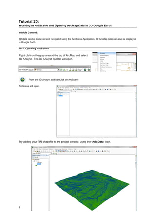
  • 1. 1     Tutorial 20: Working in ArcScene and Opening ArcMap Data in 3D Google Earth Module Content: 3D data can be displayed and navigated using the ArcScene Application. 3D ArcMap data can also be displayed in Google Earth. 20.1. Opening ArcScene Right click on the grey area at the top of ArcMap and select 3D Analyst. The 3D Analyst Toolbar will open. From the 3D Analyst tool bar Click on ArcScene ArcScene will open. Try adding your TIN shapefile to the project window, using the ‘Add Data’ icon.
  • 2. 2     20.2. Moving Around the 3D Environment You can use the navigate tools (in the main toolbar along the top of the display area) to move around the 3D environment. Fly Zoom to Target Navigate Centre on Set Observer Standard ArcMap tools Target Tips: 20.3. Draping shapefiles over terrain Add a shapefile, in this case we will add an aerial photograph (e.g. aerial 5 in the tutorial data folder) but you could use this technique with any shapefile. Right click on the layer name in the table of contents and click on Properties. Select the ‘Base Heights’ tab In the ‘Elevation from Surfaces’ box, click on Floating on a Custom Surface. The TIN that you added to the project should already be selected. There is an option to offset, but in this case we want the default option ‘0’ Click Apply, and then click OK - Hold down the left mouse button to rotate the landscape - Hold down the right mouse button to zoom - Use the mouse roller ball to pan - Click the left mouse button to speed up - Click the right mouse button to slow down - Push down on the mouse roller ball to speed up  
  • 3. 3     The aerial photograph will be draped over the TIN. You may need to zoom in so that you can see it. You might need to improve the image quality of the aerial photographs. Right click on the layer name in the table of contents and select Properties. Select the ‘Rendering’ tab. Increase the ‘Quality enhancement for raster images’ scale bar towards ‘High’. Click Apply, you may have to wait a few minutes while it renders. Then click OK. Repeat the ‘Base Heights’ operation for all your shapefiles.
  • 4. 4     20.4. Extruding Shapefiles You might want to extrude shapefiles, for example to make 3D buildings. Add a shapefile, such as a shapefile created by exporting building data from an AutoCAD file (see tutorial 19). Right click on the layer name in the table of contents to open the layer properties, and set the ‘base height’ as above. Then select the ‘Extrusion’ tab. You can make all the features the same height by putting a number in the extrusion box. If you want your buildings to be different heights, then you need to use, or create a column in the attribute table with height information. For example, ‘Storeys’ then ‘1’, ‘2’, ‘3’ and so on. Then use the ‘Expression Builder’ to calculate the different heights. Double click the column name in the top left hand box, so that it is added to the Expression box (bottom left) and then type ‘*3’ or whatever you think represents a storey. Here is an example where all the buildings have been extruded to 4m.
  • 5. 5     20.5. Creating an Animation Once you have added your shapefiles, you can then start creating a video in ArcScene. Right click in the area of grey at the top of the screen and select Animation to display the animation toolbar. The ‘Animation’ drop down menu allows you to access the animation manager, save your animation, export a video and clear the animation. The camera icon is the ‘key frame’. Use this icon to navigate between points. Click on the key frame icon then click on the map to create the first key frame. Navigate to where you want the second point to be, select the key frame tool again and click. The route will be saved. The icon that looks like a play/pause button opens the animation controls. You can play through the key frames you just saved. You can also use these to record, pause and stop your animation. By clicking on ‘options’ you can change the length of the animation. If you want to create an animation which appears like you are flying, it is best to use the bird and then the record button. 20.6. Exporting your Animation To export your animation, click Animation, then select Export Animation... You can choose to export as an .avi file or as sequential images. *Note: When ArcScene is exporting the file, do not use the computer for anything; otherwise the export will be interrupted.
  • 6. 6     20.7. Opening ArcMap data in Google Earth a) Exporting Shapefiles as KML from ArcMap There is a free script available from ESRI for exporting shapefiles to KML. The extension allows users to export GIS data for use in Google Earth. Any point, polyline or polygon dataset can be exported to KML and opened in Google Earth. A .pdf can be downloaded which explains how to use the script. The script is available from: http://arcscripts.esri.com/details.asp?dbid=14273 b) Using the ‘Data Import’ Feature in Google Earth You can use the import data into Google Earth using the ‘Data Import’ feature. You can then view your data as one of the layers in the ‘layers panel’. For details see: http://earth.google.com/userguide/v4/ug_importdata.html