The International Journal of Engineering & Science is aimed at providing a platform for researchers, engineers, scientists, or educators to publish their original research results, to exchange new ideas, to disseminate information in innovative designs, engineering experiences and technological skills. It is also the Journal's objective to promote engineering and technology education. All papers submitted to the Journal will be blind peer-reviewed. Only original articles will be published.
The papers for publication in The International Journal of Engineering& Science are selected through rigorous peer reviews to ensure originality, timeliness, relevance, and readability.
Geotechnical Investigation for Design and Construction of Civil Infrastructur...theijes
The International Journal of Engineering & Science is aimed at providing a platform for researchers, engineers, scientists, or educators to publish their original research results, to exchange new ideas, to disseminate information in innovative designs, engineering experiences and technological skills. It is also the Journal's objective to promote engineering and technology education. All papers submitted to the Journal will be blind peer-reviewed. Only original articles will be published.
International Journal of Engineering Research and DevelopmentIJERD Editor
Electrical, Electronics and Computer Engineering,
Information Engineering and Technology,
Mechanical, Industrial and Manufacturing Engineering,
Automation and Mechatronics Engineering,
Material and Chemical Engineering,
Civil and Architecture Engineering,
Biotechnology and Bio Engineering,
Environmental Engineering,
Petroleum and Mining Engineering,
Marine and Agriculture engineering,
Aerospace Engineering.
The document analyzes the geotechnical properties of soils from three locations along the Ogun River in Nigeria as potential materials for earth dam construction. Soil samples were collected and tested for properties like particle size distribution, liquid limit, plastic limit, optimum moisture content, permeability, and shear strength. The results found that the soils required improvement to be suitable for dam construction. Specifically, the soils had permeability that was too high and would allow excessive seepage. While meeting some criteria, no single soil possessed all ideal properties. Improvement methods could make the soils adequate, though further studies are needed to address property deficiencies.
Engineering geophysical investigation around ungwan doka, shika area within t...Alexander Decker
The document summarizes an engineering geophysical investigation conducted around Ungwan Doka, Shika area in northwestern Nigeria. Vertical electrical soundings using Schlumberger configuration were performed at 18 locations. The resistivity data revealed 2-4 subsurface layers: a topsoil layer, a weathered basement layer, a partly weathered/fractured basement layer, and a fresh basement layer. Resistivity values and layer thicknesses varied across layers and locations. The study characterized the subsurface and evaluated its competence, structural variations, groundwater potential, and safety of the hydrogeologic system to inform engineering design.
Site investigation plays a crucial role in identifying adverse ground conditions that can jeopardize tunnel projects and cause delays or accidents during construction. Key aspects of site investigation include desk studies, walkover surveys, subsurface exploration techniques like drilling and cone penetration tests, and geophysical methods. Case studies of past tunneling accidents demonstrate how lack of knowledge about geological conditions from inadequate site investigation can lead to failures like collapses from groundwater ingress or unstable rock masses. A multistage site investigation employing various techniques can best acquire information to reduce risks from unexpected ground conditions during tunnel excavation.
This document provides an overview of geotechnical site investigation. It discusses the history and development of site investigations, different approaches to site investigations from desk studies to limited investigations with monitoring, and the typical sequence of a geotechnical site investigation. It also describes various subsurface exploration techniques including geophysics, boring, drilling, probing, and in situ testing methods.
Stratigraphic influence on geotechnical properties of subgrade soils along th...Alexander Decker
This document summarizes a study of the stratigraphic influence on geotechnical properties of subgrade soils along the Irrua-Auchi road in Nigeria. Laboratory and field tests were conducted to analyze the engineering properties of soils derived from different geologic formations underlying the road: the Ameki Formation, Imo Shale, and Ajali Sandstone. Results showed the soils had similar geotechnical properties but pavement deflections, indicating stability, varied with geology, with the most stable segment underlain by Ajali soils and the least stable by Imo shale soils. Stratification of underlying geologic units thus influenced the pavement performance.
THE EFFECT OF GEOTECHNICAL PROPERTIES ON THE BEARING CAPACITY OF SELECTED SOI...IAEME Publication
The document summarizes a study on the geotechnical properties and bearing capacity of soils in Al-Najaf Governorate, Iraq. Laboratory and field tests were conducted including standard penetration tests, water level observations, and permeability tests. The soils were found to be predominantly clayey with high plasticity (CH), and groundwater was detected between 0.5-0.9 meters below surface. Bearing capacity was calculated using dynamic and static methods, ranging from 21.45-31.35 tonnes/m2 and 9.82-14.20 tonnes/m2 respectively. The study concluded the soils will require engineering treatments before construction.
This document provides an overview of a publication containing papers from the Symposium on Geophysical Methods for Geotechnical Investigations. The publication covers both surface and borehole geophysical techniques applied to environmental and geotechnical engineering problems. Surface methods provide horizontal maps or vertical profiles of subsurface properties, while borehole methods provide continuous vertical logs of properties along boreholes. Together, surface and borehole methods provide complementary data for characterizing geological formations and groundwater.
A study was conducted at a sawah site in Ghana to examine the relationship between landscape
position and some selected soil properties with the aim of generating adequate data for modeling
landscape relationships and to aid both researchers and farmers in taking critical management
decisions. Soil properties namely total porosity, moisture content, infiltration rates, hydraulic
conductivity, sand content, silt content, clay content, gravel concentration, bulk density, soil pH, total
nitrogen, soil organic matter and cation exchange capacity were collected and analysed. Data were
collected at the foot slopes, middle slopes and at the upper slopes from four major landuses (maize, oil
palm, natural vegetation and plantain) in the study area. Simple statistical parameters such as mean
and standard deviation were used to analyse the data. Moisture content, total porosity, soil pH, organic
matter and carbon and total nitrogen increased downslope whilst sand content, clay content, bulk
density occurred at upper slopes decreased downslope. Management practices appeared to have
influenced infiltration rate, hydraulic conductivity and silt content.
This document outlines laboratory experiments for a geotechnical engineering course, including determining liquid limit, plastic limit, dry density, particle size distribution, compaction, and specific gravity of soil. It describes how geotechnical investigations are performed through surface and subsurface exploration to obtain soil properties for engineering design, and notes tests will be conducted in groups and laboratory experiment reports should follow a specific format.
Geotechnical Investigation into the Causes of Cracks in Building: A Case Stu...inventionjournals
The document discusses a study investigating the causes of cracks in the Egbogha building at the University of Ibadan in Nigeria. Soil samples were collected from around the building and tested in the lab to determine their geotechnical properties. The tests found the soil to be poorly graded sandy clay with high clay content, indicating medium potential for shrinkage or swelling. Water infiltration during the rainy season causes differential heaving when drying out, resulting in the cracks seen in the building's walls. The study concludes that the expansive soil supporting the building's foundation is the likely cause of the cracks, rather than settlement. Recommendations include installing drainage, monitoring usage and repairs, and further investigating foundation soil settlement.
Geotechnical Investigation of Soil around Arawa-Kundulum Area of Gombe Town, ...iosrjce
This Project work involves the investigation of soil at Arawa- Kundulum area in Gombe town of
North Eastern Nigeria. The study area is a newly developing part of Gombe town but has been defaced by
cracks on buildings, and this calls for appropriate geotechnical investigation of soils of the area. Soil samples
were collected from eight (8) different locations within the study area. At each trial pit, four (4) samples were
collected at intervals of 0.5m, 1.0m, 1.5m and 2.0m depths below ground level and were investigated for their
Geotechnical properties with a view to classifying for their suitability or otherwise for infrastructural
development. The geotechnical tests carried out on these samples include: Natural moisture content, Specific
gravity, Physico-chemical tests, Particle size distribution (Sieve analysis), Atterberg limits and Compaction
tests. All these tests were carried out using the BS 1377, (1990) Parts 1 - 9 specification. Based on the test
results obtained from the study area, comparison were made with some standard specifications and it was
revealed that the soil samples are clayey soils which are unsuitable for most engineering construction because
they have poor bearing capacities. However from the investigation above, the main geotechnical problems that
affect design and engineering structures are found to be presence of expansive soil composed of silt and clay
with high plasticity index. This soil is therefore not recommended for Engineering purposes. In the event of
siting a building project, the soil should be stabilized before embarking on the project
1892 soil investigation for foundationsChandra Mouli
This document provides the code of practice for subsurface investigation for foundations in India. It outlines the importance of subsurface exploration to understand soil and groundwater conditions at construction sites. The document discusses site reconnaissance, previous land use history, suitable investigation methods like trial pits, boreholes, geophysical tests. It provides guidance on number and spacing of exploration points based on site size and geology. Exploration depth should be 1.5 times the width of foundation below foundation level. The code aims to help engineers obtain complete subsurface information for foundation design and construction.
Application of Electrical Resistivity Tomography for Soil Competence Study in...IIJSRJournal
This study was carried out to determine soil competence around University of Benin Teaching Hospital and its environs using electrical resistivity tomography method. The Wenner Schlumberger Array Profiling method was used to give information of the subsurface resistivity. The result of the study showed that in ERT 1, highly competent soil were observed with resistivity values between 725Ωm and greater than 6546Ωm, which means that the area is underlain by clay sand at the top and sand/laterite/bedrock at the bottom. ERT 2 is characterized by highly competent soils with high resistivity values between 899Ωm to greater than 7851 Ωm, which indicates that the soil is underlain by sand/laterite/bedrocks. Furthermore, ERT 3 is group as highly competent soils, with resistivity values between762Ωm and greater than 6980 Ωm; this shows that the profile 3 is underlain by sand/laterite/bed rock. The study shows that though most part of the area contains soils that are competent, because of the presence of clay which on most occasion in the Niger Delta are expandable, detailed Geophysical and Civil engineering studies should be carried out before the erection of high rising engineering structures such as network masts, buildings and water tanks within the study area.
This study used electrical resistivity imaging, seismic refraction tomography, and azimuthal resistivity soundings to assess an active open dump site in Kaduna, Nigeria. The objectives were to delineate potential leachate plumes and subsurface pathways that could transport contaminants. Results from resistivity imaging identified low resistivity zones (6-33 ohm-m) representing leachate plumes. Resistivity and seismic models also delineated fractures beneath the weathered basement layer that could act as pathways. Longitudinal conductance values of 0.02-0.1 mhos indicated poor protective capacity, allowing leachate to reach shallow aquifers. Azimuthal resistivity soundings at 45 m depth
This chapter discusses engineering geological site investigations. The objectives of a site investigation are to understand subsurface conditions like soil/rock profiles, groundwater levels, and physical properties in order to determine appropriate foundation types and provide design recommendations. A site investigation involves planning, execution of field and lab testing, and report writing. Fieldwork includes collecting disturbed and undisturbed samples, in-situ tests, and borehole logging. Proper data interpretation is also important and involves understanding measurement scales, analyzing data, and drawing conclusions. The overall goal is to safely and economically design and construct engineering projects based on site-specific conditions.
Subsurface Sedimentary Thickness and Structural types of Formations in Imo St...IIJSRJournal
Imo State is part of the Niger Delta of Nigeria that is blessed with a lot of natural resources. These have not been fully exploited and subsurface information of the region is needed to enhance the exploration of these resources. In this work airborne gravity data obtained from the Nigerian Geological Survey Agency has been interpreted to obtain information on the structural types, sedimentary thickness and hydrocarbon potentials of the state. These were archived by use of Oasis Montaj software. The residual gravity anomaly was first extracted from the field data with a polynomial operation and then enhanced by a high pass filter before gridding, modelling and depth estimation, using inverse and forward modelling and Euler deconvolution operation. The results reveal syncline and anticline structures with strike angles of varying degrees and strike-slip faults. The depth to evaluated anomalous bodies was between 4,001 m and 9,439 m, all located in the Ameki and Imo Formations which are composed of sandstones and shales. The structures and formations they occur are favorable environments for hydrocarbon habitation as is common in the Niger delta basin. The Euler depth estimates gave sedimentary thickness ranges of 113.5 m to 8,717 m and falls within basement depths in the Niger Delta
The document summarizes the stages of a site investigation which includes a desk study, site reconnaissance, detailed exploration and sampling, field/in-situ testing, and laboratory testing. The objectives are to assess suitability, enable adequate design, plan construction, determine ground changes, and document the investigation in a report. Site investigations involve exploring ground conditions through methods like boreholes, trial pits, and geophysical surveys to inform engineering design decisions.
An application of the 2 d d.c. resistivity method in building site investigat...Alexander Decker
This study applied 2D DC resistivity methods to investigate the subsurface geology at a building site in south-south Nigeria. Two resistivity profiles identified four distinct geologic layers - a shallow clay layer, a layer of weathered rock materials, a layer of fractured basement rock, and fresh bedrock. The profiles revealed a potential geologic structure, likely a fracture, that could cause building failure if constructed across. The study concluded piles should extend to competent bedrock for major buildings, while shallow foundations can be used for small buildings, given the bedrock lies below weathered material. The integration of surface geophysics with borehole data would improve accuracy of the subsurface model.
Interpretation of Structural Terrace of Sheets: 303, 304 and 305 using Geophy...IIJSRJournal
The study on interpretation of aeromagnetic data of parts of Bamenda Massif (sheet 303, 304, and 305) South-eastern Nigeria has been evaluated. The data sets used are digitized maps of aeromagnetic data. The study area was characterized into four distinct zones such as A, B, C and D. Zone A occur in the northern portion and it is characterized by linear anomaly of amplitude 66.2 - 98.5nT. Zone B and C primarily share the same structural grain connecting the southwest and southern portions of the study area where they are characterised with large ''bull eye'' and narrow shaped anomalies. Zone D occupies the western and central portions of the study area showing features of magnetic highs and lows due to sporadic intrusions. The analysis review lineament structures aligned in a NE-SW and NW-SE trends which is in similar pattern to the initial rifting of the southern Nigerian margin system. Zone A, B and C are bound by intrusives of igneous origin. However, the interconnectivity of the structural lineaments makes them stand out as pathways for mineralization. Thus, most of the lineaments are believed to be located at a depth range of <246.5m to 258.2m, 258.2m to 437m, 212.9m to >626.1m and 769.2m to 1039.7m within the subsurface rocks.
The advantages and disadvantages of site investigation tools and exploratory ...George Majunting
This document discusses and compares the advantages and disadvantages of various site investigation tools and exploratory techniques used in geoenvironmental engineering. It examines earth augers, bailers, spring steel fingers, split spoon samplers, grab sampling, hand augers and split barrel devices, test pits, and boreholes. It concludes that site investigation equipment is important for obtaining necessary data before beginning any construction, and that each tool has its own strengths and weaknesses, with errors potentially from human negligence as well as equipment.
This document provides information on the Geotechnical Engineering I course offered at the University of Hawassa, Faculty of Technology. The 5 ECTS credit, compulsory course is offered in the 4th semester to B.Sc. in Civil and Urban Engineering students. The course objectives are for students to gain knowledge in geotechnical engineering topics and skills in identifying soil properties and analyzing soil behavior. The course consists of 7 units covering topics such as soil formation, physical properties, classification, permeability, effective stress concept, compressibility, and consolidation over 15 weeks. Student assessment includes assignments, lab work, midterm and final exams.
The document discusses foundations and site exploration for determining soil properties. It describes the functions of foundations, including distributing loads, preventing uneven settling, and providing stability. Subsurface investigation methods are outlined, such as trial pits, probing, geophysical tests, and borings used to determine soil types and properties at varying depths. The document also discusses determining the bearing capacity of soils using methods like plate load tests and penetration tests.
ROLE OF GEOLOGY IN SELECTION OF CONSTRUCTION SITE of Mega ProjectsEhsan Ahmed khan
The document discusses the role of geology in selecting construction sites for mega projects. Mega projects are defined as those costing over $1 billion that gain large public attention, such as bridges, tunnels, highways, airports, power plants, and dams. Site selection for mega projects is based on geological factors like geological surveys, bearing capacity, slope stability, water tables, rock type, seismic activity, soil erosion, altitude, and climatic parameters. Geological surveys are needed to understand the site conditions and features. Bearing capacity, seismic activity, slope stability, water content, rock type, soil erosion, soil type, and climatic parameters must all be considered for safe construction and foundation.
Engineering geology involves the application of geology to construction projects. It is concerned with the rock and soil conditions of construction sites. Engineering geology provides information vital for planning, designing, and building structures like dams, bridges, and buildings. It examines the geology, geomorphology, and material properties of construction sites to understand subsurface conditions, availability of construction materials, and geologic hazards that could impact structures. Subdisciplines of engineering geology include physical geology, geomorphology, mineralogy, petrology, and economic geology. It aids in site selection, foundation design, and town planning by considering the geologic factors that influence construction and development.
The International Journal of Engineering & Science is aimed at providing a platform for researchers, engineers, scientists, or educators to publish their original research results, to exchange new ideas, to disseminate information in innovative designs, engineering experiences and technological skills. It is also the Journal's objective to promote engineering and technology education. All papers submitted to the Journal will be blind peer-reviewed. Only original articles will be published.
The papers for publication in The International Journal of Engineering& Science are selected through rigorous peer reviews to ensure originality, timeliness, relevance, and readability.
The International Journal of Engineering & Science is aimed at providing a platform for researchers, engineers, scientists, or educators to publish their original research results, to exchange new ideas, to disseminate information in innovative designs, engineering experiences and technological skills. It is also the Journal's objective to promote engineering and technology education. All papers submitted to the Journal will be blind peer-reviewed. Only original articles will be published.
The International Journal of Engineering and Science (The IJES)theijes
The International Journal of Engineering & Science is aimed at providing a platform for researchers, engineers, scientists, or educators to publish their original research results, to exchange new ideas, to disseminate information in innovative designs, engineering experiences and technological skills. It is also the Journal's objective to promote engineering and technology education. All papers submitted to the Journal will be blind peer-reviewed. Only original articles will be published.
The papers for publication in The International Journal of Engineering& Science are selected through rigorous peer reviews to ensure originality, timeliness, relevance, and readability.
1. The document describes the development of an automatic welding and inspection system for nuts welded on support hinges using machine vision. The system aims to improve over manual inspection by reducing variability and costs.
2. The system uses a vision system and conveyor belt to automatically capture images of welded parts and identify defects like missing or eccentrically placed nuts using template matching algorithms. An actuator module transfers parts between welding and inspection stages.
3. The study presents the system design and algorithm development including template creation, matching approaches, and setting inspection thresholds to minimize false acceptance/rejection. Experimental results demonstrate the system's ability to accurately detect different defect types in welded parts.
The International Journal of Engineering and Science (The IJES)theijes
This document summarizes a study on the socio-economic impact of mining operations in the Jamuna Kotma Coal Field region of Anuppur district, Madhya Pradesh, India. The study used participatory field methods and Kendall's ranking coefficient method to categorize villages into different development regions based on social, economic, and demographic indicators. Very high development regions had more schools, electricity access, and agricultural development due to mining activities. However, development was not equal across villages. The study found regional disparities existed in 1991 and 2001, with some villages having very low development. The authors conclude attention must be paid to less developed regions to reduce disparities over time.
The International Journal of Engineering and Science (The IJES)theijes
The International Journal of Engineering & Science is aimed at providing a platform for researchers, engineers, scientists, or educators to publish their original research results, to exchange new ideas, to disseminate information in innovative designs, engineering experiences and technological skills. It is also the Journal's objective to promote engineering and technology education. All papers submitted to the Journal will be blind peer-reviewed. Only original articles will be published.
The papers for publication in The International Journal of Engineering& Science are selected through rigorous peer reviews to ensure originality, timeliness, relevance, and readability.
The International Journal of Engineering and Science (The IJES)theijes
The International Journal of Engineering & Science is aimed at providing a platform for researchers, engineers, scientists, or educators to publish their original research results, to exchange new ideas, to disseminate information in innovative designs, engineering experiences and technological skills. It is also the Journal's objective to promote engineering and technology education. All papers submitted to the Journal will be blind peer-reviewed. Only original articles will be published.
The papers for publication in The International Journal of Engineering& Science are selected through rigorous peer reviews to ensure originality, timeliness, relevance, and readability.
The International Journal of Engineering & Science is aimed at providing a platform for researchers, engineers, scientists, or educators to publish their original research results, to exchange new ideas, to disseminate information in innovative designs, engineering experiences and technological skills. It is also the Journal's objective to promote engineering and technology education. All papers submitted to the Journal will be blind peer-reviewed. Only original articles will be published.
The International Journal of Engineering and Science (The IJES)theijes
The International Journal of Engineering & Science is aimed at providing a platform for researchers, engineers, scientists, or educators to publish their original research results, to exchange new ideas, to disseminate information in innovative designs, engineering experiences and technological skills. It is also the Journal's objective to promote engineering and technology education. All papers submitted to the Journal will be blind peer-reviewed. Only original articles will be published.
The papers for publication in The International Journal of Engineering& Science are selected through rigorous peer reviews to ensure originality, timeliness, relevance, and readability.
Environmental Impact Assessment of Gully Erosion in Umuoji, Idemili North L.G...theijes
Fivegully sites from five villages namely Uruegbe, Akala-etiti, Umuazu, Dianokwu and Dimechem were selected in Umuoji and soil samples collected from the various locations respectively, to evaluate the impact of gully erosion within the environment in Umuoji. Results indicated that the soil samples have Atterberg limit that might be considered low, while liquid limit (LL) ranged from 25 – 30, the plasticity index (PI) ranged from 1 – 5%, which suggested that the soils are slight plastic. Moisture content was moderate. Chemical analysis, on the other hand, revealed that the soil samples are fairly low. Organic matter content ranged from 7.4 - 12%, the soil PH level ranged from 5 – 6 which is within slightly acidic and moderate acidic. Engineering properties and physio-chemical characteristics of soil samples from gully selected area, thus, provided insights into the contributing factors of gully formations that are prevalent in the Umuoji environment. Concrete tracing and backfilling of gully affected areas is recommended to reduce the impact of gullying or the force of rain-drop. This will reduce the formation and widening of the incipient gullies.
Hydrogeological Application of Refraction Seismicsiosrjce
IOSR Journal of Environmental Science, Toxicology and Food Technology (IOSR-JESTFT) multidisciplinary peer-reviewed Journal with reputable academics and experts as board member. IOSR-JESTFT is designed for the prompt publication of peer-reviewed articles in all areas of subject. The journal articles will be accessed freely online.
Poster presented on computer modelling of tar sands quarry in the Nigerian tar sands belt in SW Nigeria at the 50th AEG International Conference in Los Angeles.
The International Journal of Engineering and Science (The IJES)theijes
The International Journal of Engineering & Science is aimed at providing a platform for researchers, engineers, scientists, or educators to publish their original research results, to exchange new ideas, to disseminate information in innovative designs, engineering experiences and technological skills. It is also the Journal's objective to promote engineering and technology education. All papers submitted to the Journal will be blind peer-reviewed. Only original articles will be published.
Sub-Soil Investigation of a Proposed Construction Site at Kyami District, Abu...iosrjce
Sub-soil investigation of a proposed construction site located at Kyami district of the Federal Capital
Territory (F.C.T.) Abuja, Nigeria, was carried out to determine the suitability of the soil to host civil
engineering structures. The investigation involved excavation of trial pits and obtaining both disturbed and
undisturbed samples for laboratory analysis. Classification tests carried out showed that about half of the soil
samples analysed is composed mainly of clayey sand (SC), with the remaining half composed of silty sand (SM)
and non-plastic sand respectively; each occurring inalmost equal proportion. Analysis showed that the soil has
low plasticity characteristics. This implies that the potential for swelling and shrinking when wet and dry that
could have negative impact on the stability of structures placed on them is low.The soils therefore have fair to
good engineering characteristics necessary for construction work and with a mean allowable bearing capacity
of 137.8KPa the soils have moderate strength capable of carrying normal civil engineering structures.
High-Resolution 3D Seismic: Coal Mines FieldsAli Osman Öncel
1. CONSOL developed a robust coal geophysics program between 1985-2000 that utilized various seismic and non-seismic methods to address exploration, engineering, and environmental challenges.
2. A key case study involved using high-resolution 3D surface seismic data to detect a complex geologic anomaly called a "roll" in a coal seam, which showed up as amplitude anomalies.
3. Interpretation of the 3D seismic data found that the roll meandered into the property from the north and turned southeast, allowing mine plans to be adjusted to account for more difficult mining conditions on the roll's western flank.
The International Journal of Engineering & Science is aimed at providing a platform for researchers, engineers, scientists, or educators to publish their original research results, to exchange new ideas, to disseminate information in innovative designs, engineering experiences and technological skills. It is also the Journal's objective to promote engineering and technology education. All papers submitted to the Journal will be blind peer-reviewed. Only original articles will be published.
Evaluation of sub-soil geo-electric properties in a proposed power sub-statio...IJERA Editor
This document summarizes the results of an electrical resistivity survey conducted at a proposed power substation site in Rivers State, Nigeria. The survey found that the subsurface is characterized by two main geo-electric layers: an upper layer of lower resistivity lateritic to silty sands extending to depths of 2-3 meters, and a lower layer of higher resistivity fine to coarse sands and gravels forming the major aquifers in the area. Analysis showed that the subsoil falls within the non-corrosive class, indicating that subsurface electrical installations would pose minimal hazards with basic precautions.
Corrosion is a mechanism that degrades materials and causes structural failures in infrastructures, which can lead to severe effects on the environment and have direct impact on the population health. In addition, corrosion is extremely complex in the underground environment due to the variability of the local conditions. The delineation and assessment of possible areas of corrosion along Obama-Kolo Creek, in the Niger Delta region was carried out using Earth resistivity measurement. The aim of this study is to evaluate the influence of soil resistivity upon metals buried underground. In this investigation, an Abem SAS 300B meter was used and 20 sounding points were carried out using the Schlumberger array along the pipeline route. A total spread (AB) of 45m was adopted with the assumption that the depth of penetration is th of the total current electrode spread (AB). The results obtained showed that subsoil resistivity values for depths of 2 – 12m required for the underground pipe laying with resistivities in the range of 8 Ohm-m to 78 Ohm-m along Obama – Kolo Creek with a mean of 43 Ohm-m. The low resistivity encountered throughout the study has been attributed to the influence of saline water intrusion in the area. The average thickness of this area is 7m. Basically, most of the geoelectric graphs showed three layers, H-type curves. Generally, the subsurface soil is made up of subsoil lithology of mainly clayey/sandy clay material with different degree of saturation. This is an indication that any underground metallic material will be exposed to high corrosivity environment, hence appropriate cathodic protection will be required.
This document presents a thesis submitted by Itamuko, Omoniyi Johnson to the Department of Applied Geophysics at the Federal University of Technology Akure, Nigeria in partial fulfillment of the requirements for a Bachelor of Technology degree in Applied Geophysics. The thesis involves 3D seismic structural interpretation and petrophysical evaluation of the 'X'-Field located in the onshore Niger Delta Basin in Nigeria. The study utilizes 3D seismic data and well logs to map faults, horizons, and structural features in order to better understand the hydrocarbon trapping mechanisms and reservoir properties in the field. The results provide information on the potential for hydrocarbon accumulation and estimates of hydrocarbon reserves in the 'X'-Field.
Classification and Assessment of Soil Compaction Level in Amassoma, Bayelsa S...Premier Publishers
Soil compaction is essential in construction. The failure to displace air from between particles when constructing buildings, roads, parking lots, dams, walls, swimming pools, or utility trench inevitably leads to unwanted soil movement and water penetration into the earth beneath construction projects.Soil compaction is one of the most important aspects of any earthwork construction. Assessing the level of compaction of soil in Amassoma is to ascertain the compatibility or rate of compaction of the underlining earth materials (soils).Nine (9) samples were collected at regular intervals of 1m, 2m, 3m, 4m, 5m, 6m, 7m, 8m and 9m which were used for the analyses. The samples collected were subjected to different laboratory test to determine the index properties and the level of compaction of the soil. Sieve analysis result of the samples shows that the percentage of fines and sands are in the range of 21.57%-63.20% and 36.80% and78.73%, respectively.Atterberg result also shows that the soil liquid limit (LL) is in the range of 48.51%-54.90% plastic limit (PL) ranges from 29/13%-36.51% and 14.78%-25.18% for plastic index (PI). Another experiment shows that the value of maximum Dry Density (MD) and Optimum Moisture Content (OMC) are 1.70g/cm3 and 18 40%. The analysis done for this work reveals that the soil in the area (Amassoma) can be classified as medium to high plastic soil (unified soil classification system) and that the soil in moderately compacted. Comparing the CBR test results with the Nigeria standard, the soils found in Amassoma can be used as sub-grade materials for construction.
Twelve vertical electrical soundings, VES, were carried out in parts of Abua in northwestern part of Rivers State in the sedimentary basin of the Niger delta of Nigeria, to determine the overburden layering and infer the aquifer depth/thickness and probable safe structural foundation depths in the region. The Schlumberger array method was employed using an ABEM 300B Terrameter and maximum current electrode spread of 400 m. The computed apparent resistivity field log values were plotted against the current electrode spreads and interpreted with IPWIN 2 and Sulphure 8 software to obtain the overburden thickness/depth, resistivity and the isopach map and then infer the subsoil layering thickness including potential aquifer zones within the depths of investigation in the area. The curve types revealed that three and four geoelectric sections were penetrated by the survey array with overburden thickness ranging from 4.2 m in Elok community to 91.7 m in Ilghom community. Potential aquifers with variable thickness from 5 to 60 m at depths of from 4.5 m and below the earth surface were identified. The subsurface soils types can support structural foundations from depths of 1.0 m and below the earth surface based on the type of building/engineering structures.
Distribution of petroleum product within the oil rich Niger Delta area of Nigeria is a daunting
task because of its deltaic nature. To solve this challenge, fixed fuel dispensing stations will be built in the
coastal environment to receive and make supplies available to fishermen and marine transporters. Building of
such fuel stations require proper foundation design. Soil test results of the region was obtained and a foundation
design was made to ascertain the number of piles pile depth, pile spacing, skin friction, lateral load bearing
capacity and end bearing capacity. API codes where used to check and ensure that the results obtained are
within safety limits. This will ensure that the offshore structure completes it intended and designed life span.
The document summarizes a study on variations in groundwater flow potential in parts of Imo State, Nigeria. Ten boreholes across the study area underlain by the Benin Formation were investigated. Transmissivity values, which indicate groundwater flow potential, ranged from 311.04 to 388,800 m2/day. The highest potential was at Futo borehole, while the lowest was at Uratta. The study area was segmented into areas of moderate and high potential. Areas with lower hydraulic conductivity and transmissivity values generally had moderate potential, while others with higher values had high potential. The groundwater flow potential model shows potential increases from north to south. The transmissivity values obtained can support sustainable groundwater
This document summarizes subsurface investigation methods for groundwater exploration, including test drilling and borehole geophysical logging techniques. Test drilling methods collect samples and logs to characterize subsurface geology and identify aquifers. Geophysical logging lowers sensor tools to measure physical properties like resistivity, natural radiation, and temperature that indicate lithology, porosity, and groundwater flow. These subsurface techniques provide detailed data for groundwater exploration but are more expensive than surface methods.
Porosity Estimation Using Wire-Line Log to Depth in Niger Delta, NigeriaIOSR Journals
Porosity modeling was carried out in oil-wells of stacked reservoirs in south-east Niger Delta using
gamma ray, resistivity, and sonic logs to determine lithologies and porosities. Lithologies of the formation were
identified as sand and shale. Porosity values range from 0.013% to 94.08%. Porosity decreases with depth in
normal compacted formation for the two wells .The following porosity equation has been modeled for the study
area, Z = -3E-05Øz + 0.5785. This implies that, in the absence of core samples, porosity, φz can be estimated at
any depth, Z in the area of study. The results of the porosity modeling can be applied in petroleum evaluation
and overpressure prediction. It may also be useful for sedimentary basin analysis of the region.
Groundwater prospecting and Aquifer Delineation using Vertical Electrical Sou...iosrjce
A total of twenty seven (27) vertical electrical soundings (VES) where carried out on the basement
complex area of Kumbotso Local Government Area of Kano with a spread of 40m-45m adopted. The results
obtained revealed three to four geo-electric layers of the subsurface. The third weathered basement and a forth
fractured basement rock constitutes the Aquiferous water bearing layers with resistivity ranges from 6Ωm -
265Ωm respectively with average thickness of 19m and 15m respectively. The result shows the weathered
regolith to be thicker than the fractured bedrock layer; average depth range of boreholes in the area is between
30m-35m while the average static water levels in dug wells is 8.3m. It is highly recommended that a spread of
between 75-85m be used in the future and also the use of EM method to locate deep fractures as important in
maximizing the borehole yield.
Integrated Geophysical and Geotechnical Evaluation of Foundation Failure in P...inventionjournals
Geophysical and geotechnical methods have been integrated with the aim of assessing characteristics of sub-surface layers to identify why structures in some parts of Ikere-Ekiti Southwestern Nigeria are failing or sinking as a result of foundation failure. Eight (8) vertical electrical sounding (VES) were carried out using resistivity meter and six (6) pits were dug to a depth of 1.2m. Six disturbed soil samples were collected from the six dug pits for the study. These samples were subjected to geotechnical tests in the laboratory, which include moisture content, shear test, Atterberg limit and grain size analysis. The acquired VES data were processed and interpreted using partial curve matching technique. The results of the all the mall the eight VES produced H curves. This curve type manifested three layers which are composed of sandy-clay, clayeysand/weathered basement and weathered basement/rock head. The depth o rockhead ranges from 12.1 to 43.2m. VES stations four and five have deeper depth to rock head (i.e. 21.3 to 43.2m) while other locations have lesser depth to rockhead (i.e.1 12.1m to 17.5m). The second layer has the lowest resistivity values meaning that it is somewhat conductive owing to clayey sand deposition and weathered area. Geotechnical test shows that the soils in the study area generally has high moisture content, low plasticity, and from grain size distribution, high concentrations of silt and clay. From the result, it is established that the layer in which the foundations are built upon are rated as poor to fairly competent. This might be as a result of poor drainage system characterised the study area which brought about the local deposition of the supposed subsoil. Therefore, high moisture content made the subsoil to lose its competency thereby causing the structures in the study area to subside
This document investigates the effects of geotechnical properties on the exploitation of laterite deposits in southwest Nigeria. Samples were collected from 6 locations and tested for properties like specific gravity, permeability, grain size distribution, compaction characteristics, strength and plasticity. Equations used to determine properties like permeability, grain size distribution, compaction parameters, stress-strain behavior and Atterberg limits are provided. The factor of safety for slope stability was found to be satisfactory for 5 locations but unsafe for 1 location due to loading conditions.
Similar to The International Journal of Engineering and Science (The IJES) (20)
Ivanti’s Patch Tuesday breakdown goes beyond patching your applications and brings you the intelligence and guidance needed to prioritize where to focus your attention first. Catch early analysis on our Ivanti blog, then join industry expert Chris Goettl for the Patch Tuesday Webinar Event. There we’ll do a deep dive into each of the bulletins and give guidance on the risks associated with the newly-identified vulnerabilities.
5th LF Energy Power Grid Model Meet-up SlidesDanBrown980551
5th Power Grid Model Meet-up
It is with great pleasure that we extend to you an invitation to the 5th Power Grid Model Meet-up, scheduled for 6th June 2024. This event will adopt a hybrid format, allowing participants to join us either through an online Mircosoft Teams session or in person at TU/e located at Den Dolech 2, Eindhoven, Netherlands. The meet-up will be hosted by Eindhoven University of Technology (TU/e), a research university specializing in engineering science & technology.
Power Grid Model
The global energy transition is placing new and unprecedented demands on Distribution System Operators (DSOs). Alongside upgrades to grid capacity, processes such as digitization, capacity optimization, and congestion management are becoming vital for delivering reliable services.
Power Grid Model is an open source project from Linux Foundation Energy and provides a calculation engine that is increasingly essential for DSOs. It offers a standards-based foundation enabling real-time power systems analysis, simulations of electrical power grids, and sophisticated what-if analysis. In addition, it enables in-depth studies and analysis of the electrical power grid’s behavior and performance. This comprehensive model incorporates essential factors such as power generation capacity, electrical losses, voltage levels, power flows, and system stability.
Power Grid Model is currently being applied in a wide variety of use cases, including grid planning, expansion, reliability, and congestion studies. It can also help in analyzing the impact of renewable energy integration, assessing the effects of disturbances or faults, and developing strategies for grid control and optimization.
What to expect
For the upcoming meetup we are organizing, we have an exciting lineup of activities planned:
-Insightful presentations covering two practical applications of the Power Grid Model.
-An update on the latest advancements in Power Grid -Model technology during the first and second quarters of 2024.
-An interactive brainstorming session to discuss and propose new feature requests.
-An opportunity to connect with fellow Power Grid Model enthusiasts and users.
Skybuffer SAM4U tool for SAP license adoptionTatiana Kojar
Manage and optimize your license adoption and consumption with SAM4U, an SAP free customer software asset management tool.
SAM4U, an SAP complimentary software asset management tool for customers, delivers a detailed and well-structured overview of license inventory and usage with a user-friendly interface. We offer a hosted, cost-effective, and performance-optimized SAM4U setup in the Skybuffer Cloud environment. You retain ownership of the system and data, while we manage the ABAP 7.58 infrastructure, ensuring fixed Total Cost of Ownership (TCO) and exceptional services through the SAP Fiori interface.
HCL Notes und Domino Lizenzkostenreduzierung in der Welt von DLAUpanagenda
Webinar Recording: https://www.panagenda.com/webinars/hcl-notes-und-domino-lizenzkostenreduzierung-in-der-welt-von-dlau/
DLAU und die Lizenzen nach dem CCB- und CCX-Modell sind für viele in der HCL-Community seit letztem Jahr ein heißes Thema. Als Notes- oder Domino-Kunde haben Sie vielleicht mit unerwartet hohen Benutzerzahlen und Lizenzgebühren zu kämpfen. Sie fragen sich vielleicht, wie diese neue Art der Lizenzierung funktioniert und welchen Nutzen sie Ihnen bringt. Vor allem wollen Sie sicherlich Ihr Budget einhalten und Kosten sparen, wo immer möglich. Das verstehen wir und wir möchten Ihnen dabei helfen!
Wir erklären Ihnen, wie Sie häufige Konfigurationsprobleme lösen können, die dazu führen können, dass mehr Benutzer gezählt werden als nötig, und wie Sie überflüssige oder ungenutzte Konten identifizieren und entfernen können, um Geld zu sparen. Es gibt auch einige Ansätze, die zu unnötigen Ausgaben führen können, z. B. wenn ein Personendokument anstelle eines Mail-Ins für geteilte Mailboxen verwendet wird. Wir zeigen Ihnen solche Fälle und deren Lösungen. Und natürlich erklären wir Ihnen das neue Lizenzmodell.
Nehmen Sie an diesem Webinar teil, bei dem HCL-Ambassador Marc Thomas und Gastredner Franz Walder Ihnen diese neue Welt näherbringen. Es vermittelt Ihnen die Tools und das Know-how, um den Überblick zu bewahren. Sie werden in der Lage sein, Ihre Kosten durch eine optimierte Domino-Konfiguration zu reduzieren und auch in Zukunft gering zu halten.
Diese Themen werden behandelt
- Reduzierung der Lizenzkosten durch Auffinden und Beheben von Fehlkonfigurationen und überflüssigen Konten
- Wie funktionieren CCB- und CCX-Lizenzen wirklich?
- Verstehen des DLAU-Tools und wie man es am besten nutzt
- Tipps für häufige Problembereiche, wie z. B. Team-Postfächer, Funktions-/Testbenutzer usw.
- Praxisbeispiele und Best Practices zum sofortigen Umsetzen
Salesforce Integration for Bonterra Impact Management (fka Social Solutions A...Jeffrey Haguewood
Sidekick Solutions uses Bonterra Impact Management (fka Social Solutions Apricot) and automation solutions to integrate data for business workflows.
We believe integration and automation are essential to user experience and the promise of efficient work through technology. Automation is the critical ingredient to realizing that full vision. We develop integration products and services for Bonterra Case Management software to support the deployment of automations for a variety of use cases.
This video focuses on integration of Salesforce with Bonterra Impact Management.
Interested in deploying an integration with Salesforce for Bonterra Impact Management? Contact us at sales@sidekicksolutionsllc.com to discuss next steps.
Letter and Document Automation for Bonterra Impact Management (fka Social Sol...Jeffrey Haguewood
Sidekick Solutions uses Bonterra Impact Management (fka Social Solutions Apricot) and automation solutions to integrate data for business workflows.
We believe integration and automation are essential to user experience and the promise of efficient work through technology. Automation is the critical ingredient to realizing that full vision. We develop integration products and services for Bonterra Case Management software to support the deployment of automations for a variety of use cases.
This video focuses on automated letter generation for Bonterra Impact Management using Google Workspace or Microsoft 365.
Interested in deploying letter generation automations for Bonterra Impact Management? Contact us at sales@sidekicksolutionsllc.com to discuss next steps.
Best 20 SEO Techniques To Improve Website Visibility In SERPPixlogix Infotech
Boost your website's visibility with proven SEO techniques! Our latest blog dives into essential strategies to enhance your online presence, increase traffic, and rank higher on search engines. From keyword optimization to quality content creation, learn how to make your site stand out in the crowded digital landscape. Discover actionable tips and expert insights to elevate your SEO game.
Driving Business Innovation: Latest Generative AI Advancements & Success StorySafe Software
Are you ready to revolutionize how you handle data? Join us for a webinar where we’ll bring you up to speed with the latest advancements in Generative AI technology and discover how leveraging FME with tools from giants like Google Gemini, Amazon, and Microsoft OpenAI can supercharge your workflow efficiency.
During the hour, we’ll take you through:
Guest Speaker Segment with Hannah Barrington: Dive into the world of dynamic real estate marketing with Hannah, the Marketing Manager at Workspace Group. Hear firsthand how their team generates engaging descriptions for thousands of office units by integrating diverse data sources—from PDF floorplans to web pages—using FME transformers, like OpenAIVisionConnector and AnthropicVisionConnector. This use case will show you how GenAI can streamline content creation for marketing across the board.
Ollama Use Case: Learn how Scenario Specialist Dmitri Bagh has utilized Ollama within FME to input data, create custom models, and enhance security protocols. This segment will include demos to illustrate the full capabilities of FME in AI-driven processes.
Custom AI Models: Discover how to leverage FME to build personalized AI models using your data. Whether it’s populating a model with local data for added security or integrating public AI tools, find out how FME facilitates a versatile and secure approach to AI.
We’ll wrap up with a live Q&A session where you can engage with our experts on your specific use cases, and learn more about optimizing your data workflows with AI.
This webinar is ideal for professionals seeking to harness the power of AI within their data management systems while ensuring high levels of customization and security. Whether you're a novice or an expert, gain actionable insights and strategies to elevate your data processes. Join us to see how FME and AI can revolutionize how you work with data!
Main news related to the CCS TSI 2023 (2023/1695)Jakub Marek
An English 🇬🇧 translation of a presentation to the speech I gave about the main changes brought by CCS TSI 2023 at the biggest Czech conference on Communications and signalling systems on Railways, which was held in Clarion Hotel Olomouc from 7th to 9th November 2023 (konferenceszt.cz). Attended by around 500 participants and 200 on-line followers.
The original Czech 🇨🇿 version of the presentation can be found here: https://www.slideshare.net/slideshow/hlavni-novinky-souvisejici-s-ccs-tsi-2023-2023-1695/269688092 .
The videorecording (in Czech) from the presentation is available here: https://youtu.be/WzjJWm4IyPk?si=SImb06tuXGb30BEH .
Trusted Execution Environment for Decentralized Process MiningLucaBarbaro3
Presentation of the paper "Trusted Execution Environment for Decentralized Process Mining" given during the CAiSE 2024 Conference in Cyprus on June 7, 2024.
Digital Marketing Trends in 2024 | Guide for Staying AheadWask
https://www.wask.co/ebooks/digital-marketing-trends-in-2024
Feeling lost in the digital marketing whirlwind of 2024? Technology is changing, consumer habits are evolving, and staying ahead of the curve feels like a never-ending pursuit. This e-book is your compass. Dive into actionable insights to handle the complexities of modern marketing. From hyper-personalization to the power of user-generated content, learn how to build long-term relationships with your audience and unlock the secrets to success in the ever-shifting digital landscape.
Generating privacy-protected synthetic data using Secludy and MilvusZilliz
During this demo, the founders of Secludy will demonstrate how their system utilizes Milvus to store and manipulate embeddings for generating privacy-protected synthetic data. Their approach not only maintains the confidentiality of the original data but also enhances the utility and scalability of LLMs under privacy constraints. Attendees, including machine learning engineers, data scientists, and data managers, will witness first-hand how Secludy's integration with Milvus empowers organizations to harness the power of LLMs securely and efficiently.
A Comprehensive Guide to DeFi Development Services in 2024Intelisync
DeFi represents a paradigm shift in the financial industry. Instead of relying on traditional, centralized institutions like banks, DeFi leverages blockchain technology to create a decentralized network of financial services. This means that financial transactions can occur directly between parties, without intermediaries, using smart contracts on platforms like Ethereum.
In 2024, we are witnessing an explosion of new DeFi projects and protocols, each pushing the boundaries of what’s possible in finance.
In summary, DeFi in 2024 is not just a trend; it’s a revolution that democratizes finance, enhances security and transparency, and fosters continuous innovation. As we proceed through this presentation, we'll explore the various components and services of DeFi in detail, shedding light on how they are transforming the financial landscape.
At Intelisync, we specialize in providing comprehensive DeFi development services tailored to meet the unique needs of our clients. From smart contract development to dApp creation and security audits, we ensure that your DeFi project is built with innovation, security, and scalability in mind. Trust Intelisync to guide you through the intricate landscape of decentralized finance and unlock the full potential of blockchain technology.
Ready to take your DeFi project to the next level? Partner with Intelisync for expert DeFi development services today!
Fueling AI with Great Data with Airbyte WebinarZilliz
This talk will focus on how to collect data from a variety of sources, leveraging this data for RAG and other GenAI use cases, and finally charting your course to productionalization.
In the rapidly evolving landscape of technologies, XML continues to play a vital role in structuring, storing, and transporting data across diverse systems. The recent advancements in artificial intelligence (AI) present new methodologies for enhancing XML development workflows, introducing efficiency, automation, and intelligent capabilities. This presentation will outline the scope and perspective of utilizing AI in XML development. The potential benefits and the possible pitfalls will be highlighted, providing a balanced view of the subject.
We will explore the capabilities of AI in understanding XML markup languages and autonomously creating structured XML content. Additionally, we will examine the capacity of AI to enrich plain text with appropriate XML markup. Practical examples and methodological guidelines will be provided to elucidate how AI can be effectively prompted to interpret and generate accurate XML markup.
Further emphasis will be placed on the role of AI in developing XSLT, or schemas such as XSD and Schematron. We will address the techniques and strategies adopted to create prompts for generating code, explaining code, or refactoring the code, and the results achieved.
The discussion will extend to how AI can be used to transform XML content. In particular, the focus will be on the use of AI XPath extension functions in XSLT, Schematron, Schematron Quick Fixes, or for XML content refactoring.
The presentation aims to deliver a comprehensive overview of AI usage in XML development, providing attendees with the necessary knowledge to make informed decisions. Whether you’re at the early stages of adopting AI or considering integrating it in advanced XML development, this presentation will cover all levels of expertise.
By highlighting the potential advantages and challenges of integrating AI with XML development tools and languages, the presentation seeks to inspire thoughtful conversation around the future of XML development. We’ll not only delve into the technical aspects of AI-powered XML development but also discuss practical implications and possible future directions.
This presentation provides valuable insights into effective cost-saving techniques on AWS. Learn how to optimize your AWS resources by rightsizing, increasing elasticity, picking the right storage class, and choosing the best pricing model. Additionally, discover essential governance mechanisms to ensure continuous cost efficiency. Whether you are new to AWS or an experienced user, this presentation provides clear and practical tips to help you reduce your cloud costs and get the most out of your budget.
Introduction of Cybersecurity with OSS at Code Europe 2024Hiroshi SHIBATA
I develop the Ruby programming language, RubyGems, and Bundler, which are package managers for Ruby. Today, I will introduce how to enhance the security of your application using open-source software (OSS) examples from Ruby and RubyGems.
The first topic is CVE (Common Vulnerabilities and Exposures). I have published CVEs many times. But what exactly is a CVE? I'll provide a basic understanding of CVEs and explain how to detect and handle vulnerabilities in OSS.
Next, let's discuss package managers. Package managers play a critical role in the OSS ecosystem. I'll explain how to manage library dependencies in your application.
I'll share insights into how the Ruby and RubyGems core team works to keep our ecosystem safe. By the end of this talk, you'll have a better understanding of how to safeguard your code.
Introduction of Cybersecurity with OSS at Code Europe 2024
The International Journal of Engineering and Science (The IJES)
1. The International Journal Of Engineering And Science (IJES)
||Volume||2 ||Issue|| 11||Pages|| 08-16||2013||
ISSN(e): 2319 – 1813 ISSN(p): 2319 – 1805
Evaluation of Sub-Soil Geotechnical Properties for Shallow
Foundation Design in Onne, Rivers State, Nigeria
1,
Ngah, S.A And 2,Nwankwoala, H.O
1,
Institute Of Geosciences And Space Technology, Rivers State University Of Science And Technology, PMB
5080, Nkpolu-Oroworukwo, Port Harcourt, Nigeria
2,
Department Of Geology, College Of Natural And Applied Sciences, University Of Port Harcourt, PMB 5323,
Choba, Port Harcourt, Nigeria.
-------------------------------------------------------ABSTRACT--------------------------------------------------This study aims at establishing the sub-soil types and profile to ascertain the engineering characteristics of the
underlying soils in Onne area of Rivers State, Nigeria and recommend appropriate foundation design and
construction for large scale ground and elevated water storage facilities in the area. Four borings were
accomplished using a percussion rig with the aid of augers. Representative samples were analyzed in the
laboratory in accordance with relevant geotechnical engineering standards. Results of the study revealed that
within the maximum depth of 15m of boring, the area was found to consist of about 0.2m thick of organic topsoil
followed by light brown sandy-clay underlain by a light brown to yellowish brown fine to medium grained,
medium dense sand up to 15m depth of investigation. The study also reveals that superficial light brown sandy
clay is suitable in quality to carry shallow or raft foundation load development and also has thickness to
completely dissipate the influence of such foundations in the area. For such foundations which could be placed
between 1.0m and 3.0m depth, an average allowable bearing pressure qa of100kN/m2 is recommended for the
area. The size of projects in the area in terms of loading presupposes that a shallow foundation placed at a
minimum of about 900mm below existing ground level may be appropriate. For such foundation and for a
maximum consolidation settlement of about 60mm, an allowable bearing pressure of 100kpa is recommended..
KEY WORDS: Sub-soils, Geotechnical Properties, foundation design, Construction, Niger Delta.
---------------------------------------------------------------------------------------------------------------------------------------Date of Submission: 28 October 2013
Date of Acceptance: 20 November 2013
---------------------------------------------------------------------------------------------------------------------------------------
I.
INTRODUCTION
It has been observed in recent times, that many property developers in Nigeria ignore drastically the
role of geotechnical information in the planning, design, construction, operation as well as safety of civil
engineering infrastructures. This neglect results to failure of structures (Annoret al., 1987; Amadiet al., 2012;
Youdeowei &Nwankwoala, 2013). Frequent structural failure of civil engineering infrastructures in parts of Port
Harcourt Metropolis has become a source of worry to so many persons. It is for this reason that a clear
understanding of the occurrence, composition, distribution, geologic history as well as the geotechnical
properties of subsurface soils in the area is necessary. Considering the fact that the Eastern Niger Delta is within
the coastal zone, geotechnical investigation /considerations are very desirable. The coastal zone which
comprises the beach ridges and mangrove swamps is underlain by an alternating sequence of sand and clay with
a high frequency of occurrence of clay within 10m below the ground surface. Because of the nearness of these
compressible clays to the surface, the influence of imposed loads results to consolidation settlement. The impact
of the imposed load is exacerbated by the thickness and consistency of the compressible layer. This, in addition
to other intrinsic factors contributes to the failure of civil engineering structures.
The knowledge of the geotechnical characteristics of Onne, Rivers State, Nigeria is very desirable for
design and construction of foundation of future civil engineering structures in order to minimize adverse effects
and prevention of post construction problems. Some studies have been carried out on geotechnical properties of
the sub-soils generally (Nwankwoala &Amadi, 2013; Oke &Amadi, 2008; Okeet al., 2009).For the purpose of
generating relevant data inputs for the design and construction of foundations for proposed structures, it is
imperative that the site be geo-technically characterized through sub-soil investigation. This paper therefore,
aims at establishing significant subsoil types and profile, investigation of the engineering characteristics of all
such sub-soils to generate the required data relevant to the foundation design and construction of structures.
www.theijes.com
The IJES
Page 8
2. Evaluation Of Sub-Soil Geotechnical Properties…
Description of the Study Area
The study area is located in Onne (Fig.1), Rivers State, Nigeria. The terrain is generally flat or near –
flat typical of the Niger Delta region. Generally, the area lies within the flat land/plain of the Niger Delta
commonly characterized by superficial stratum of deltaic lateritic materials directly overlying coastal plain sand
of the Benin Formation. Generally, the Niger Delta Sedimentary Basin is made up of three rock types.
Lithostratigraphically, these rocks are divided into the oldest Akata Formation (Paleocene), the Agbada
Formation (Eocene) and the Youngest Benin Formation (Miocene to Recent). Generally, the present knowledge
of the geology of the Niger Delta was derived from the works of the following researchers (Reyment, 1965;
Short &Stauble, 1967; Murat, 1970; Merki, 1970) as well as the exploration activities of the oil and gas
companies in Nigeria. The formation of the so called proto-Niger Delta occurred during the second depositional
cycle (Campanian-Maastrichtian) of the southern Nigerian basin. However, the modern Niger Delta was formed
during the third and last depositional cycle of the southern Nigerian basin which started in the Paleocene.
The geologic sequence of the Niger Delta consists of three main Tertiary subsurface lithostratigraphic units
(Short &Stauble, 1967) which are overlain by various types of Quaternary deposits (Table 1).
Table 1: Quaternary deposits of the Niger Delta (after Etu-Efeotor&Akpokodje, 1990)
Geologic Unit
Lithology
Alluvium
Age
Gravel, Sand, clay, silt
Freshwater Backswamp, meander belt
Saltwater Mangrove Swamp and backswamp
Sand, clay, some silt, gravel
Medium-fine sands, clay and some
silt
Active/abandoned beach ridges
Sand, clay, and some silt
Sombreiro-warri deltaic plain
Quaternary
Sand, clay, and some silt
II.
METHODS OF STUDY
Field Investigation
The field investigation took place within the first week of December,2012.The field activities among
other things included three numbers of hand-auger soil borings distributed across the site and one deep boring at
the center. Borings were accompanied by disturbed and undisturbed sampling. As at the time of field
investigation, groundwater stood at 9.00m below the ground surface.
www.theijes.com
The IJES
Page 9
3. Evaluation Of Sub-Soil Geotechnical Properties…
Soil Boring
The three borings were accomplished using a 100mm diameter hand-auger, advanced to a depth of
about 5.0m below the existing ground surface while the deep boring was studied by boring one (1) hole (BH4)
to a depth of 15m using a Percussion boring rig with the aid of augers, clay cutter or shell. .
Soil Sampling
During boring, disturbed soil samples were collected at regular intervals of about 1.0m or at significant
changes in soil types. Undisturbed samples were also collected in U100 open tube samplers in two randomly
selected boreholes at 1.0m and 1.5m depths. Shown in the borehole lithologs are the various sampling types and
depths. All samples were examined, identified, classified roughly in the field and all data and information
carefully recorded in the borehole logs which are presented in Fig. 2.
Laboratory Testing
All samples obtained in the field were carefully preserved and transported to the laboratory where they
were subjected to more detailed visual inspection and descriptions. Thereafter, representative samples were
selected from each stratum for laboratory analysis in accordance with relevant geotechnical engineering
standards including BS 1377 (1990).Disturbed samples so selected were subjected to the following laboratory
classification tests:(i) Particle size analysis by sieving. (ii) Atterberg limits (liquid and plastic limits).(iii)
Natural moisture content. Sieve analysis of cohesive soils particularly involved soaking oven-dried samples in
water overnight and washing through sieve No. 200 (75 microns opening) while remnants retained on sieve No.
200 were oven-dried and sieved mechanically. This procedure ensures greater accuracy in determining actual
proportion of fines or materials finer than sieve number 200. Such fines were then analysed using the
hydrometer method based on Stoke’s Law. The undisturbed and mostly cohesive samples collected in the course
of boring were subjected to: (i)
unconsolidated–undrained or quick triaxial tests at cell pressures of 100kPa,
and 300kPa; and (ii) Oedometer consolidation test.
The shear strength parameters cu and u of the cohesive soil samples were obtained from
unconsolidated undrained triaxial test, while shear strength parameter of the granular soils were evaluated from
average SPT-number of the respective stratum. The dimensionless bearing capacity factors after Vesic has been
adopted in computing the bearing capacity for shallow foundation:
qu = cNcSc + D(Nq - 1) Sq + 0.5 BNS
Where
qu = ultimate bearing capacity
C = undrained cohesion
q = effective overburden
= effective unit weight
Nc, Nq, Ny= Bearing capacity factors
Sc, Sq, Sy= Shape factors
The net allowable, qn(a), bearing capacity of the soil has been evaluated with a factor of safety (F.S) of
3.0 and a summary of the net allowable bearing capacity are presented in Table 4. The submerged unit weight
introduced in the analysis is to account for the effect of water on the Surcharge component of bearing capacity.
Ultimate pile capacities for axial loading for 406mm, 500mm and 600mm tubular driven steel piles have
been estimated for the project. Soil profile and geotechnical data obtained from the site were used for the
analysis. The following relationships were used for the calculations:
(i)
Qu = Qb + Qs
(ii)
Qu = 9CuAb +CuAs
(iii)
Qu = P’oNqAb + ksPo’ tanAs
for Clay
for Sand
Where, Qu= Ultimate bearing capacity of pile (kN)
www.theijes.com
The IJES
Page 10
4. Evaluation Of Sub-Soil Geotechnical Properties…
Qb= Total end bearing (kN)
Qs = Skin fiction resistance (kN)
Cu =Undrained shear strength of the soil (kN/m2)
As = Surface area of pile shaft (m2) = BD
Ab = Base area of pile shaft (m2) =
B
2
4
P’o = Effective overburden pressure =
w
D
2
B = Diameter of pile
D = Depth of penetration
= Adhesion factor
= Friction angle between the soil and pile wall = 0.60
ks= Coefficient of horizontal soil stress = 1.5ko
ko = Coefficient of earth pressure at rest = 1-Sin
The calculated ultimate pile capacities for borehole are shown below. Allowable axial pile capacity has
been obtaining by applying safety factor of 2.5 for driven piles. Plot of depth of penetration versus allowable
pile capacity for the various boreholes is shown in the Appendices,
Settlement Analysis
Total consolidation settlement (c) has been computed for foundation breadth (B) between 1.002.50metres, subjected to a net allowable bearing capacity of 100kN/m2. Based on the soil lithology, the
thickness of the consolidating layer for a square foundation is taken as the depth to the point where the induced
vertical stress () is equal to 0.55qn. The induced vertical stress () at the centre of the consolidating layer
has been used in computing c. The consolidation settlement has been computed from the expression.
pc =gPoed
= mvzH
= mv x 0.55qn x 1.5B
whereg = Coefficient which depends on the type of clay
Poed = Settlement as calculated from oedometer test
mv = Coefficient of volume compressibility
qn
= Net foundation pressure
B
= Breadth of foundation.
An mv value of 0.20m2/MN, which corresponds to the adopted net allowable bearing capacity for the site, has
been used in the settlement analysis.
III.
RESULTS
3.1. Soil Stratigraphy
The data obtained from the boring, soil sampling, field penetration tests and laboratory gradation tests
were interpreted to determine the stratification of subsoils underlying the site. Within the borehole termination
depth of about 15m, the site is characterized superficially by light brown sandy- clay underlain by light brown to
yellowish brown fine to medium grained, medium dense soil materials.
www.theijes.com
The IJES
Page 11
5. Evaluation Of Sub-Soil Geotechnical Properties…
IV.
ENGINEERING PROPERTIES OF MAJOR SUB-SOILS
From results of field and laboratory analyses on samples of the soil superficially dominating the site up
to borehole termination depth of about 15.0m, the site is characterized by the light-brown sandy- clay. Some
selected engineering characteristics for this soil material is summarized in Table 2.
Table 2: Engineering Properties of the soil
Engineering Properties
Natural moisture content (%)
Bulk Density (kN/m3)
Liquid Limit (%)
Plastic Limit (%)
Plasticity Index (%)
Dry unit weight (kN/m3)
Effective unit weight (kN/m3)
Undrained cohesion (kN/m2)
Min
23.3
18.8
39
25
14
15.0
9.0
40
3
Mean
26.0
19.2
49
27
22
15.2
9.2
42
4
0.33
Cl
Undrained (degree)
Void ratio
Classification (Unified)
Max
28.6
19.4
58
28
30
15.4
9.4
44
6
0.58
CH
0.45
CH
Physical Properties of Sand:
Medium Dense Sand: The sand is fine to medium grained, well graded, medium dense. The layers are almost
of uniform gradation.The relevant engineering parameters of sands are shown in Table 3.
Table 3: Relevant Engineering Parameters
Engineering Properties
Effective particle size, d10 (mm)
Effective particle size, d30 (mm)
Effective particle size, d50 (mm)
Effective particle size, d60 (mm)
Coefficient of uniformity Cu=d60/d10
Coefficient of curvature Cc = d230/(d60 . d10 )
Specific Gravity
Classification (Unified)
Min
0.02
0.25
0.50
0.60
18
3.56
2.59
SP
Max
0.05
0.40
0.70
0.90
30
5.21
2.79
Mean
0.04
0.35
0.60
0.75
24
4.39
2.72
Table 4: Bearing Capacity
BH
No
Undrained
Cohesion ‘cu’
(kN/m3)
18.80
5
42
2.00
18.80
5
42
18.80
5
42
1.00
19.10
5
40
2.00
19.10
5
40
3.00
www.theijes.com
Angle of
friction
(degrees)
3.00
2
Unit
Weight γ
(kN/m3)
1.00
1
Depth of
Sample (m)
19.10
5
40
The IJES
Breadth/
Length
ration
0.50
0.75
1.00
0.50
0.75
1.00
0.50
0.75
1.00
0.50
0.75
1.00
0.50
0.75
1.00
0.50
0.75
1.00
Allowable
bearing
capacity ‘qa’
(kN/m2)
108
116
123
113
120
126
116
125
130
104
111
117
108
114
121
112
118
125
Page 12
6. Evaluation Of Sub-Soil Geotechnical Properties…
1.00
19.40
5
41
19.40
5
41
1.00
19.20
6
41
2.00
19.20
6
41
3.00
19.20
6
0.50
0.75
1.00
0.50
0.75
1.00
0.50
0.75
1.00
0.50
0.75
1.00
0.50
0.75
1.00
0.50
0.75
1.00
41
3.00
4
5
2.00
3
19.40
41
107
114
120
111
117
124
114
121
128
113
120
127
118
124
131
122
129
136
Table 5: Axial Pile Capacity for Pile Foundation
Pile
Size
(mm)
Depth of
Penetration
(m)
Ultimate Pile
Base
Resistance
(kN)
53
53
146
80
80
222
116
116
320
5.0
10.0
15.0
5.0
10.0
15.0
5.0
10.0
15.0
406
500
600
Ultimate Pile
Shaft
Resistance
(kN)
33
186
267
59
229
331
71
274
398
Ultimate Axial
Pile Capacity
(kN)
34
95
166
56
123
221
75
156
287
Table 6: Total Consolidation Settlement
Settlement c (mm)
Foundation breadth, B (m)
1.0
1.5
2.0
2.5
16.50
24.75
33.00
41.25
V.
DISCUSSIONS
Results of the study revealed that the major sub-soils underlying the study area have about 0.2m thick
organic topsoil followed by light brown sandy- clay which exists to about 10mdepth underlain by light brown to
yellowish brown colored medium dense sand up to termination depth of about 15m.
VI.
SHALLOW/RAFT FOUNDATIONS
Shallow or raft foundation is the most appropriate in the area since a soft to firm silty-clay exists up to
10m depth and underlain by another fine to medium grained sand. The calculated bearing capacities could be
used in determining the foundation type for structures. An average bearing capacity of 100kN/m 2 is
recommended.
VII.
PILE FOUNDATION
Axial Pile Capacity: The types of piles to be adopted in the study area are those that are driven (displacement
piles) e.g. pre-cast concrete and steel cased piles. However, the versatility and cost effectiveness of a particular
type of pile is the governing factor in the recommendation. The safe working load of piles are dependent on
factors such as pile diameter, founding depth and method of installation which is usually best determined by a
specialist-piling contractor from a pile load test. The values of total consolidation settlement are presented in
Table 6.
www.theijes.com
The IJES
Page 13
7. Evaluation Of Sub-Soil Geotechnical Properties…
The computed settlement values presented above for a square foundation size of between 1.00 – 2.50m is less
than the allowable maximum settlements suggested by Skempton and MacDonald (1956) for isolated
foundations on clays of 65mm, Hence the foundation can sustain the suggested allowable bearing pressure of
100kN/m2.
www.theijes.com
The IJES
Page 14
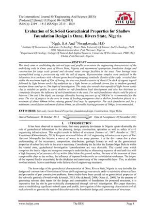
8. Evaluation Of Sub-Soil Geotechnical Properties…
Fig.5: Consolidation Test for BH 2 @ 3.OOm
Fig. 6: Axial Pile Capacity Analysis for BH 4
VIII.
CONCLUSIONS
The superficial light brown sandy clay is suitable in quality to carry shallow or raft foundation load
from proposed development and also possesses thickness to completely dissipate the influence of such
foundations. For such foundations which could be placed between 1.0m and 3.0m depth, an average allowable
bearing pressure qa of100kN/m2is recommended for the site. The safe working loads of piles are dependent on
factors such as pile diameter, founding depth and method of installation which is usually best determined by a
specialist-piling contractor from a pile load test. Ultimate pile capacities for axial loading for 406mm,
500mm and 600mmtubular driven steel piles have been estimated for the project. Soil profile and
geotechnical data obtained from the site were used for the analysis. It is generally accepted that pile foundation
design is not complete without pile load test. Therefore it is recommended that pile load test be conducted at the
site to ensure the design adopted can be safely carried.
REFERENCES
[1]
[2]
[3]
Amadi, A.N; Eze, C.J; Igwe, C.O; Okunlola, I.A and Okoye, N.O (2012).Architect’s and geologist’s view on the causes of
building failures in Nigeria. Modern Applied Science, Vol.6 (6): 31 – 38.
Annor, A.E; Olasehinde, P.I and Pal, P.C (1987). Basement fracture patterns in the control of water channels – An example from
Central Nigeria. Paper presented at the 23 rd Annual Conference of the Nigerian Mining and Geosciences Society, Benin, pp9.
British Standard Methods of Test for soils for Civil Engineering Purposes. B.S 1377: Part 2, 1990. Published by the British
Standards Institution, pp 8 – 200.
www.theijes.com
The IJES
Page 15
9. Evaluation Of Sub-Soil Geotechnical Properties…
[4]
[5]
[6]
[7]
[8]
[9]
[10]
[11]
[12]
Etu-Efeotor, J.O and Akpokodje, E.G (1990).Aquifer systems of the Niger Delta.J. Mining Geol. Vol.26 (2), pp279-285
Merki, J.P.(1970). Structural Geology of the Cenozoic Niger Delta.African Geology. University of Ibadan Press.pp251-268
Murat, R.C (1970). Stratigraphy and Paleogeography of the Cretaceous and Lower Tertiary in Southern Nigeria. In: Dessauvagie,
T.T J and Whiteman, A.J (eds.). African Geology, University of Ibadan Press, Ibadan, Nigeria.Pp251 – 266.
Nwankwoala, H.O and Amadi, A.N (2003).Geotechnical Investigation of Sub-soil and Rock Characteristics in parts of ShiroroMuya-Chachaga Area of Niger State, Nigeria.
Oke, S.A and Amadi, A.N (2008).An assessment of the geotechnical properties of the sub-soil of parts of Federal University of
Technology, Minna, GidanKwano Campus, for foundation design and construction. Journal of Science, Education and
Technology, Vo.1 (2):87 – 102
Oke, S.A; Okeke, O.E; Amadi, A.N; Onoduku, U.S (2009). Geotechnical properties of the sub-soil for designing shallow
foundation in some selected parts of Chanchaga area, Minna, Nigeria. Journal of Environmental Science, 1(1):45 – 54.
Reyment, R.A (1965). Aspects of Geology of Nigeria. University of Ibadan Press, Nigeria. 133p
Short, K.C and Stauble, A.J (1967). Outline geology of the Niger Delta. Bull. Am. Ass. Petrol Geol. 54:761 – 779
Skempton, A.W and MacDonald D.H. (1956): The Allowable Settlement of Buildings, Proc. Inst. Of Civil Engineers, Part 3,
Vol. 5, pp. 727-784.
www.theijes.com
The IJES
Page 16