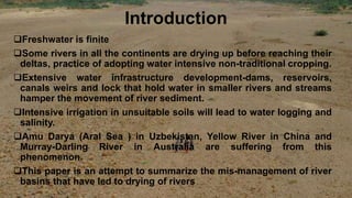
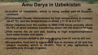
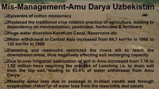
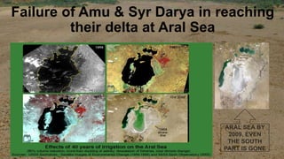
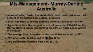
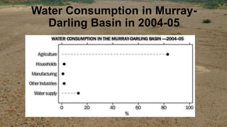
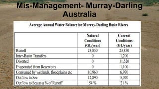
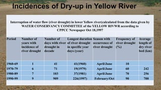
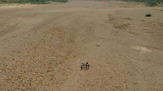
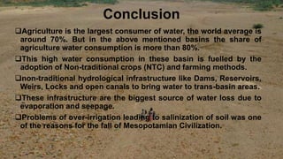
THE DRIED RIVERS
Sameer Lal, Senior Researcher
School of International Studies
Jawaharlal Nehru University
Delhi
Prof. S.K. Panday, Supervisor
Centre for Russian and Central Asian
Studies,
School of International Studies,
Jawaharlal Nehru University, Delhi
Introduction
Freshwater is finite
Some rivers in all the continents are drying up before reaching their
deltas, practice of adopting water intensive non-traditional cropping.
Extensive water infrastructure development-dams, reservoirs,
canals weirs and lock that hold water in smaller rivers and streams
hamper the movement of river sediment.
Intensive irrigation in unsuitable soils will lead to water logging and
salinity.
Amu Darya (Aral Sea ) in Uzbekistan, Yellow River in China and
Murray-Darling River in Australia are suffering from this
phenomenon.
This paper is an attempt to summarize the mis-management of river
basins that have led to drying of rivers
Amu Darya in Uzbekistan
Location of Uzbekistan, which is being central part of Eurasian
continent
Continental climate, characterized by high temperatures in summer
(42-47 oC) and low temperatures in winter (-11 oC to 2-3 oC)
Solar radiation over the country is 3000-3100 hours annually, about
65-70% of strait radiation transferring about 140-160 kkal/cm2of heat
This warms the air and soil, leading to high evapotranspiration
from water bodies and plants
Average annual rainfall is 264 mm, ranging from 97 mm to 425 mm
Evaporation from soil is aggravated due to dryness of air and low
relative humidity which is 20-30%. This is why agriculture is
possible only through irrigation
Yellow River in China
Climate in Yellow River Basin is influence by the continental
monsoon circulation system, with mean annual precipitation of
500 mm throughout the basin
The basin is divided into three reaches-
 Upper- highland climate, semi-arid continental climate,
precipitation around 300mm
 Middle-Semi-arid monsoon climate, average rainfall 750 mm
 Lower- monsoon climate, high rainfall averaging around
700mm
Murray-Darling River in Australia
Climate condition ranges from sub-tropical conditions in the far north
to Cool humid eastern uplands, temperate south-east and hot and
dry, semi-arid and arid in the western plains
Climate of the Murray-Darling Basin is relatively dry compared to
other regions of Australia
Average annual rainfall is less than 300 mm
Evaporation rate in the Basin is high, with 94% of the rainfall that falls
in the Basin is being used by plants (transpired) or evaporates from
the land and surface water
Water Content Comparison
River Water Run-Off
• Brahmaputra 687 km3
• Ganges 445 km3
• Mekong 466 km3
• Indus 235 km3
• Amu Darya 79 km3
• Yellow River 49 km3
• Murray-Darling River 23.7 km3
Mis-Management-Amu Darya Uzbekistan
Epicentre of cotton monocracy
Replaced the traditional crop rotation practice of agriculture, leading to
dependency on mechanization, pesticides, herbicides & fertilizers
Huge water diversion-KaraKum Canal, Reservoirs etc
Water withdrawal in Central Asia increased from 64.7 km3/hr in 1960 to
120 km3/hr in 1980
Damming and reservoirs restricted the rivers silt to reach the
downstream areas, thus negatively effecting soil recharging capacity
Due to over irrigation salinization of soil in Amu increased from 1.16 to
1.82 million hecs requiring the process of Leaching i.e. to drain salt
from the top soil, leading to 93.4% of water withdrawal from Amu
Darya.
Massive water loss due to seepage in in-lined canals and through
evaporation -14km3/yr of water loss from the reservoirs and canals
Failure of Amu & Syr Darya in reaching
their delta at Aral Sea
Mis-Management- Murray-Darling
Australia
Murray-Darling basin the Australia's food bowl produces 40
percent of the nation's agricultural products
Basin has been satisfying both the domestic and export market
Agriculture has the largest share of water in 2004–05 in the
Murray-Darling Basin, accounting for 83% of water consumption
in the Basin
The average flow of the river at the mouth has reduced by 61%
75% of all water is taken out of Murray River
The outflow has reduced from 54% to 21%
Water Consumption in Murray-
Darling Basin in 2004-05
Mis-Management- Murray-Darling
Australia
Mis-Management- Yellow River
China
CLIMATIC FACTORS
Rise of 0.880C in average temperature in post-world war
second era
Glacial retreat, glaciers are melting at a faster rate of 7%,
have shrunk by 17% since 1980s
Late formation of permafrost and early melting
Degradation of numerous lakes and wetlands that feed the
rivers
Mis-Management- Yellow River
conti..
Mis-Management- Yellow River China-
Anthropogenic factors
Agriculture in Post Second World War has become the main
source of consumptive use to water, it has increased by 245% ie
from 12.23 bcm in 1950-59 to 487.1 in 1990-95 of which
agriculture constitutes 80% of water consumption
Water diversion from Yellow river increased from 7.9X10⁹
m3/yrs in 1949 to 30.8X10⁹ m3/yrs 1990. A rise of 390% in water
withdrawal from 1949
Population growth has quadrupled from 130,000 in 1949 to
610,000 in the Yellow River basin
Water Diversion in Yellow River Basin
Incidences of Dry-up in Yellow River
Interruption of water flow (river drought) in lower Yellow river(calculated from the data given by
WATER CONSERVANCY COMMITTEE of the YELLOW RIVWR according to
CPPCC Newspaper Oct 18,1997
Period Number of
years with
incidence of
river drought
Number of
days with river
drought in
decade
Longest duration
of river drought
in specific year
days (year)
Season with
occurrence of
river drought
Frequency of
river drought
(%)
Average
length of
dry river
bed (km)
1960-69 1 41 41(1960) April/June 10
1970-79 6 71 19(1979) April/June 60 242
1980-89 7 103 37(1981) April/June 70 256
1990-99 9 909 226(1997) February/Oct 90 700
Conclusion
Agriculture is the largest consumer of water, the world average is
around 70%. But in the above mentioned basins the share of
agriculture water consumption is more than 80%.
This high water consumption in these basin is fuelled by the
adoption of Non-traditional crops (NTC) and farming methods.
non-traditional hydrological infrastructure like Dams, Reservoirs,
Weirs, Locks and open canals to bring water to trans-basin areas.
These infrastructure are the biggest source of water loss due to
evaporation and seepage.
Problems of over-irrigation leading to salinization of soil was one
of the reasons for the fall of Mesopotamian Civilization.
ThankYou

The dried rivers

  • 1.
    THE DRIED RIVERS SameerLal, Senior Researcher School of International Studies Jawaharlal Nehru University Delhi Prof. S.K. Panday, Supervisor Centre for Russian and Central Asian Studies, School of International Studies, Jawaharlal Nehru University, Delhi
  • 2.
    Introduction Freshwater is finite Somerivers in all the continents are drying up before reaching their deltas, practice of adopting water intensive non-traditional cropping. Extensive water infrastructure development-dams, reservoirs, canals weirs and lock that hold water in smaller rivers and streams hamper the movement of river sediment. Intensive irrigation in unsuitable soils will lead to water logging and salinity. Amu Darya (Aral Sea ) in Uzbekistan, Yellow River in China and Murray-Darling River in Australia are suffering from this phenomenon. This paper is an attempt to summarize the mis-management of river basins that have led to drying of rivers
  • 3.
    Amu Darya inUzbekistan Location of Uzbekistan, which is being central part of Eurasian continent Continental climate, characterized by high temperatures in summer (42-47 oC) and low temperatures in winter (-11 oC to 2-3 oC) Solar radiation over the country is 3000-3100 hours annually, about 65-70% of strait radiation transferring about 140-160 kkal/cm2of heat This warms the air and soil, leading to high evapotranspiration from water bodies and plants Average annual rainfall is 264 mm, ranging from 97 mm to 425 mm Evaporation from soil is aggravated due to dryness of air and low relative humidity which is 20-30%. This is why agriculture is possible only through irrigation
  • 4.
    Yellow River inChina Climate in Yellow River Basin is influence by the continental monsoon circulation system, with mean annual precipitation of 500 mm throughout the basin The basin is divided into three reaches-  Upper- highland climate, semi-arid continental climate, precipitation around 300mm  Middle-Semi-arid monsoon climate, average rainfall 750 mm  Lower- monsoon climate, high rainfall averaging around 700mm
  • 5.
    Murray-Darling River inAustralia Climate condition ranges from sub-tropical conditions in the far north to Cool humid eastern uplands, temperate south-east and hot and dry, semi-arid and arid in the western plains Climate of the Murray-Darling Basin is relatively dry compared to other regions of Australia Average annual rainfall is less than 300 mm Evaporation rate in the Basin is high, with 94% of the rainfall that falls in the Basin is being used by plants (transpired) or evaporates from the land and surface water
  • 7.
    Water Content Comparison WaterContent Comparison River Water Run-Off • Brahmaputra 687 km3 • Ganges 445 km3 • Mekong 466 km3 • Indus 235 km3 • Amu Darya 79 km3 • Yellow River 49 km3 • Murray-Darling River 23.7 km3
  • 8.
    Mis-Management-Amu Darya Uzbekistan Epicentreof cotton monocracy Replaced the traditional crop rotation practice of agriculture, leading to dependency on mechanization, pesticides, herbicides & fertilizers Huge water diversion-KaraKum Canal, Reservoirs etc Water withdrawal in Central Asia increased from 64.7 km3/hr in 1960 to 120 km3/hr in 1980 Damming and reservoirs restricted the rivers silt to reach the downstream areas, thus negatively effecting soil recharging capacity Due to over irrigation salinization of soil in Amu increased from 1.16 to 1.82 million hecs requiring the process of Leaching i.e. to drain salt from the top soil, leading to 93.4% of water withdrawal from Amu Darya. Massive water loss due to seepage in in-lined canals and through evaporation -14km3/yr of water loss from the reservoirs and canals
  • 9.
    Failure of Amu& Syr Darya in reaching their delta at Aral Sea
  • 10.
    Mis-Management- Murray-Darling Australia Murray-Darling basinthe Australia's food bowl produces 40 percent of the nation's agricultural products Basin has been satisfying both the domestic and export market Agriculture has the largest share of water in 2004–05 in the Murray-Darling Basin, accounting for 83% of water consumption in the Basin The average flow of the river at the mouth has reduced by 61% 75% of all water is taken out of Murray River The outflow has reduced from 54% to 21%
  • 11.
    Water Consumption inMurray- Darling Basin in 2004-05
  • 12.
  • 13.
    Mis-Management- Yellow River China CLIMATICFACTORS Rise of 0.880C in average temperature in post-world war second era Glacial retreat, glaciers are melting at a faster rate of 7%, have shrunk by 17% since 1980s Late formation of permafrost and early melting Degradation of numerous lakes and wetlands that feed the rivers
  • 14.
  • 15.
    Mis-Management- Yellow RiverChina- Anthropogenic factors Agriculture in Post Second World War has become the main source of consumptive use to water, it has increased by 245% ie from 12.23 bcm in 1950-59 to 487.1 in 1990-95 of which agriculture constitutes 80% of water consumption Water diversion from Yellow river increased from 7.9X10⁹ m3/yrs in 1949 to 30.8X10⁹ m3/yrs 1990. A rise of 390% in water withdrawal from 1949 Population growth has quadrupled from 130,000 in 1949 to 610,000 in the Yellow River basin
  • 16.
    Water Diversion inYellow River Basin
  • 17.
    Incidences of Dry-upin Yellow River Interruption of water flow (river drought) in lower Yellow river(calculated from the data given by WATER CONSERVANCY COMMITTEE of the YELLOW RIVWR according to CPPCC Newspaper Oct 18,1997 Period Number of years with incidence of river drought Number of days with river drought in decade Longest duration of river drought in specific year days (year) Season with occurrence of river drought Frequency of river drought (%) Average length of dry river bed (km) 1960-69 1 41 41(1960) April/June 10 1970-79 6 71 19(1979) April/June 60 242 1980-89 7 103 37(1981) April/June 70 256 1990-99 9 909 226(1997) February/Oct 90 700
  • 19.
    Conclusion Agriculture is thelargest consumer of water, the world average is around 70%. But in the above mentioned basins the share of agriculture water consumption is more than 80%. This high water consumption in these basin is fuelled by the adoption of Non-traditional crops (NTC) and farming methods. non-traditional hydrological infrastructure like Dams, Reservoirs, Weirs, Locks and open canals to bring water to trans-basin areas. These infrastructure are the biggest source of water loss due to evaporation and seepage. Problems of over-irrigation leading to salinization of soil was one of the reasons for the fall of Mesopotamian Civilization.
  • 20.