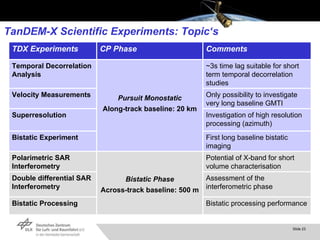
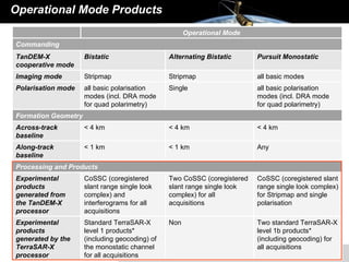
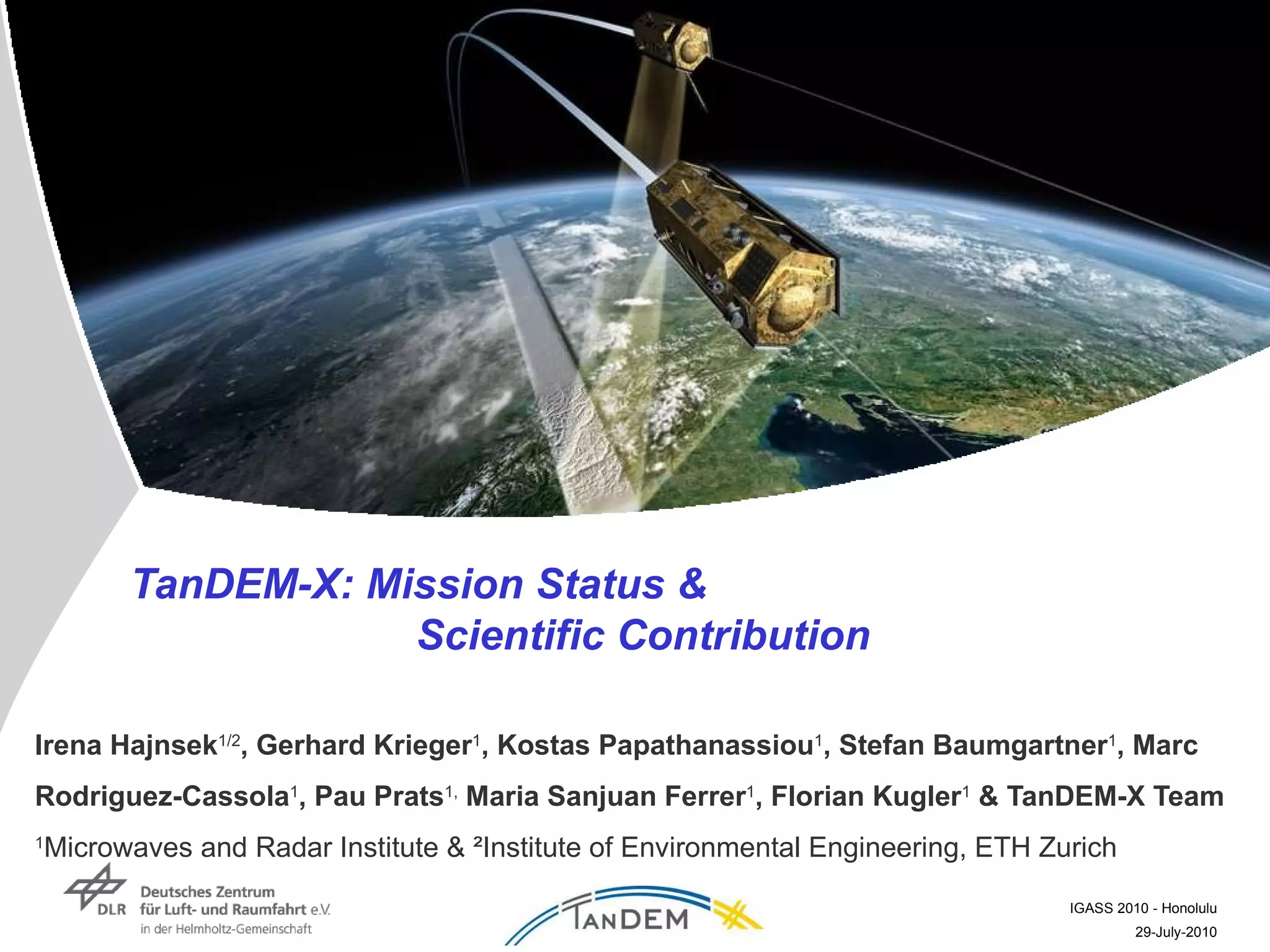
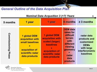
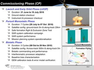
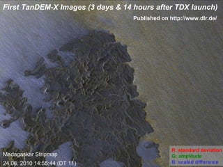
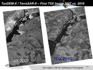
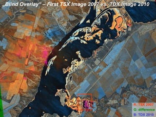
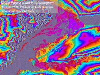
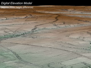
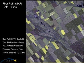
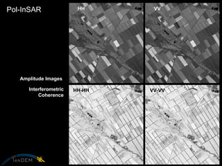
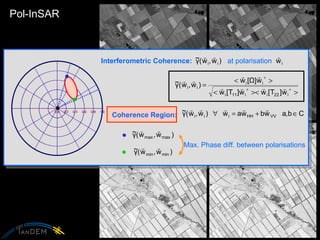
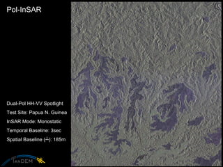
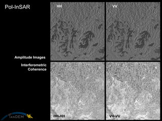
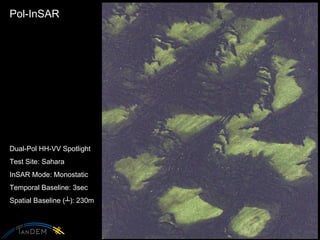
SlideShare a Scribd company logo
1 of 28
TanDEM-X: Mission Status &  Scientific Contribution Irena Hajnsek 1/2 , Gerhard Krieger 1 , Kostas Papathanassiou 1 , Stefan Baumgartner 1 , Marc Rodriguez-Cassola 1 , Pau Prats 1,  Maria Sanjuan Ferrer 1 , Florian Kugler 1  & TanDEM-X Team 1 Microwaves and Radar Institute & ²Institute of Environmental Engineering, ETH Zurich
TanDEM-X: TerraSAR-X-Add-on for  Digital Elevation Measurements Launch: 21.June 2010 (38 days ago)  from Baikonor   (first signal arrived after 15min from the ground station Troll in the Antarctic)
Standards for Digital Elevation Models (DEM) SRTM / X-SAR SRTM (DTED-1) TerraSAR-X (TanDEM-X ~ HDEM) TanDEM-X Simulation Primary Mission Objectives
Secondary Mission Objectives ,[object Object],[object Object],[object Object],[object Object],[object Object],[object Object],[object Object],[object Object],[object Object],64 km/h 56 km/h 68 km/h
Capabilities of TanDEM-X TanDEM-X is a highly flexible sensor enabling  multiple powerful imaging modes r+  r r t+  t t ,[object Object],[object Object],[object Object],[object Object],[object Object],[object Object],[object Object],[object Object],[object Object],[object Object],[object Object],New Techniques Along-Track Interferometry Cross-Track Interferometry ,[object Object],[object Object],[object Object],[object Object],[object Object],[object Object],[object Object],[object Object]
General Outline of the Data Acquisition Plan 1 global DEM acquisition with small baselines + acquisition of  scientific radar data products 1 global DEM acquisition with scaled (larger) baselines + acquisition of scientific radar data products Commissioning Phase DEM data takes for difficult terrain with different viewing geometry +  radar data products radar data products and customized DEMs with large interferometric baselines t 1 year 1 year 6 months ≥  3 months 5 months Nominal Data Acqusition 3 (+?) Years
Commissioning Phase (CP) ,[object Object],[object Object],[object Object],[object Object],[object Object],[object Object],[object Object],[object Object],[object Object],[object Object],[object Object],[object Object],[object Object],[object Object],[object Object],[object Object],[object Object],[object Object],Pursuit Monostatic Formation Flying TDX on board
First TanDEM-X Images (3 days & 14 hours after TDX launch) Madagaskar Stripmap 24.06. 2010 14:55:44 (DT 11) R: standard deviation G: amplitude B: scaled difference Published on http://www.dlr.de/
TanDEM-X / TerraSAR-X – First TSX Image 2007 vs. 2010  TSX 2007 TDX 2010 Don region (100 km northwest of Volvograd)
„ Blind Overlay“ – First TSX Image  2007 vs. TDX Image 2010   R: TSX 2007 G: difference   B: TDX 2010
TanDEM-X / TerraSAR-X – First TSX Image  2007 vs. 2010   Train 2007 (15:03 UTC) Train 2010 (14:53 UTC) R: TSX 2007 G: difference   B: TDX 2010
Phase Single Pass X-band Interferomgram  (16 June 2010: 25km along track & approx.  300m across track baseline)
Digital Elevation Model  (approx 200m height difference)
First Pol-InSAR  Data Takes Dual-Pol HH-VV Spotlight Test Site Location: Russia InSAR Mode: Monostatic Temporal Baseline: 3sec Spatial Baseline ( ┴ ): 275m
Pol-InSAR HH-HH VV-VV HH VV Interferometric Coherence Amplitude Images
Pol-InSAR Interferometric Coherence:   at polarisation  Coherence Region:  Max. Phase diff. between polarisations
Pol-InSAR 0  1  2  [m]  3
Pol-InSAR Dual-Pol HH-VV Spotlight Test Site: Papua N. Guinea InSAR Mode: Monostatic Temporal Baseline: 3sec Spatial Baseline ( ┴ ): 185m
Pol-InSAR HH-HH VV-VV HH VV Interferometric Coherence Amplitude Images
Pol-InSAR 0  2  6  [m]  8
Pol-InSAR Dual-Pol HH-VV Spotlight Test Site: Sahara InSAR Mode: Monostatic Temporal Baseline: 3sec Spatial Baseline ( ┴ ): 230m
Pol-InSAR 0  1  2  3  4  [m]  5
TanDEM-X Scientific Experiments: Topic‘s ~3s time lag suitable for short term temporal decorrelation studies Pursuit Monostatic Along-track baseline: 20 km Temporal Decorrelation Analysis Only possibility to investigate very long baseline GMTI Velocity Measurements Investigation of high resolution processing (azimuth) Superresolution First long baseline bistatic imaging Bistatic Experiment Potential of X-band for short volume characterisation Bistatic Phase Across-track baseline: 500 m Polarimetric SAR Interferometry Assessment of the interferometric phase Double differential SAR Interferometry Bistatic processing performance Bistatic Processing Comments CP Phase TDX Experiments
TanDEM-X Proposal Submission Open for Experimental Products  Please have a look @ http://tandemx-science.dlr.de
Operational Mode Products Two standard TerraSAR-X level 1b products* (including geocoding) for all acquisitions Non Standard TerraSAR-X level 1 products* (including geocoding) of the monostatic channel for all acquisitions  Experimental products generated by the TerraSAR-X processor CoSSC (coregistered slant range single look complex) for Stripmap and single polarisation  Two CoSSC (coregistered slant range single look complex) for all acquisitions CoSSC (coregistered slant range single look complex) and interferograms for all acquisitions Experimental products generated from the TanDEM-X processor Processing and Products Any < 1 km < 1 km Along-track baseline < 4 km < 4 km < 4 km Across-track baseline Formation Geometry all basic polarisation modes (incl. DRA mode for quad polarimetry) Single all basic polarisation modes (incl. DRA mode for quad polarimetry) Polarisation mode all basic modes  Stripmap Stripmap Imaging mode Pursuit Monostatic Alternating Bistatic Bistatic TanDEM-X cooperative mode Commanding Operational Mode
TanDEM-X BLOG: http://www.dlr.de
Thanks for your attention TanDEM-X Team
TanDEM-X Session ,[object Object],[object Object],[object Object],[object Object],[object Object],[object Object],[object Object]

More Related Content

What's hot

Fujimura_Presen.ppt
Fujimura_Presen.pptFujimura_Presen.ppt
Fujimura_Presen.pptgrssieee
 
WE3.L10.3: THE FUTURE OF SPACEBORNE SYNTHETIC APERTURE RADAR
WE3.L10.3: THE FUTURE OF SPACEBORNE SYNTHETIC APERTURE RADARWE3.L10.3: THE FUTURE OF SPACEBORNE SYNTHETIC APERTURE RADAR
WE3.L10.3: THE FUTURE OF SPACEBORNE SYNTHETIC APERTURE RADARgrssieee
 
IGARSS11_FFBP_CSAR_v3.ppt
IGARSS11_FFBP_CSAR_v3.pptIGARSS11_FFBP_CSAR_v3.ppt
IGARSS11_FFBP_CSAR_v3.pptgrssieee
 
Orbit determination of a non transmitting satellite
Orbit determination of a non transmitting satelliteOrbit determination of a non transmitting satellite
Orbit determination of a non transmitting satelliteClifford Stone
 
Introduction to Navigation Systems
Introduction to Navigation SystemsIntroduction to Navigation Systems
Introduction to Navigation SystemsJoseph Hennawy
 
WE4.L10.3: THE EVOLUTION OF THE US SATELLITE IR SOUNDING PROGRAM – FROM THE ...
 WE4.L10.3: THE EVOLUTION OF THE US SATELLITE IR SOUNDING PROGRAM – FROM THE ... WE4.L10.3: THE EVOLUTION OF THE US SATELLITE IR SOUNDING PROGRAM – FROM THE ...
WE4.L10.3: THE EVOLUTION OF THE US SATELLITE IR SOUNDING PROGRAM – FROM THE ...grssieee
 
FAST実験6:新型大気蛍光望遠鏡による観測報告とピエールオージェ観測所への設置計画
FAST実験6:新型大気蛍光望遠鏡による観測報告とピエールオージェ観測所への設置計画FAST実験6:新型大気蛍光望遠鏡による観測報告とピエールオージェ観測所への設置計画
FAST実験6:新型大気蛍光望遠鏡による観測報告とピエールオージェ観測所への設置計画Toshihiro FUJII
 
IGARSS11_takaku_dsm_report.ppt
IGARSS11_takaku_dsm_report.pptIGARSS11_takaku_dsm_report.ppt
IGARSS11_takaku_dsm_report.pptgrssieee
 
Synthetic aperture radar_advanced
Synthetic aperture radar_advancedSynthetic aperture radar_advanced
Synthetic aperture radar_advancedNaivedya Mishra
 
Laser-beams, spacecraft and archaeology; recent approaches to the recording, ...
Laser-beams, spacecraft and archaeology; recent approaches to the recording, ...Laser-beams, spacecraft and archaeology; recent approaches to the recording, ...
Laser-beams, spacecraft and archaeology; recent approaches to the recording, ...Paul Cripps
 
TGS NSA- Loyal 3D
TGS NSA- Loyal 3D TGS NSA- Loyal 3D
TGS NSA- Loyal 3D TGS
 
Comprehensive Space Certification Listings
Comprehensive Space Certification ListingsComprehensive Space Certification Listings
Comprehensive Space Certification ListingsJames Howard
 
FR2.L09 - PROCESSING OF MEMPHIS MILLIMETER WAVE MULTI-BASELINE INSAR DATA
FR2.L09 - PROCESSING OF MEMPHIS MILLIMETER WAVE MULTI-BASELINE INSAR DATAFR2.L09 - PROCESSING OF MEMPHIS MILLIMETER WAVE MULTI-BASELINE INSAR DATA
FR2.L09 - PROCESSING OF MEMPHIS MILLIMETER WAVE MULTI-BASELINE INSAR DATAgrssieee
 
A Conceptual Design for a Large Ground Array of Fluorescence Detectors
A Conceptual Design for a Large Ground Array of Fluorescence DetectorsA Conceptual Design for a Large Ground Array of Fluorescence Detectors
A Conceptual Design for a Large Ground Array of Fluorescence DetectorsToshihiro FUJII
 
Ground Penetrating Radar
Ground Penetrating RadarGround Penetrating Radar
Ground Penetrating RadarVARUN KUMAR
 
Development of a prototype for Fluorescence detector Array of Single-pixel Te...
Development of a prototype for Fluorescence detector Array of Single-pixel Te...Development of a prototype for Fluorescence detector Array of Single-pixel Te...
Development of a prototype for Fluorescence detector Array of Single-pixel Te...Toshihiro FUJII
 
First results from a prototype for the Fluorescence detector Array of Single-...
First results from a prototype for the Fluorescence detector Array of Single-...First results from a prototype for the Fluorescence detector Array of Single-...
First results from a prototype for the Fluorescence detector Array of Single-...Toshihiro FUJII
 
Global navigation satellite system based positioning combined
Global navigation satellite system based positioning   combinedGlobal navigation satellite system based positioning   combined
Global navigation satellite system based positioning combinedMehjabin Sultana
 

What's hot (20)

Fujimura_Presen.ppt
Fujimura_Presen.pptFujimura_Presen.ppt
Fujimura_Presen.ppt
 
WE3.L10.3: THE FUTURE OF SPACEBORNE SYNTHETIC APERTURE RADAR
WE3.L10.3: THE FUTURE OF SPACEBORNE SYNTHETIC APERTURE RADARWE3.L10.3: THE FUTURE OF SPACEBORNE SYNTHETIC APERTURE RADAR
WE3.L10.3: THE FUTURE OF SPACEBORNE SYNTHETIC APERTURE RADAR
 
IGARSS11_FFBP_CSAR_v3.ppt
IGARSS11_FFBP_CSAR_v3.pptIGARSS11_FFBP_CSAR_v3.ppt
IGARSS11_FFBP_CSAR_v3.ppt
 
Orbit determination of a non transmitting satellite
Orbit determination of a non transmitting satelliteOrbit determination of a non transmitting satellite
Orbit determination of a non transmitting satellite
 
Introduction to Navigation Systems
Introduction to Navigation SystemsIntroduction to Navigation Systems
Introduction to Navigation Systems
 
WE4.L10.3: THE EVOLUTION OF THE US SATELLITE IR SOUNDING PROGRAM – FROM THE ...
 WE4.L10.3: THE EVOLUTION OF THE US SATELLITE IR SOUNDING PROGRAM – FROM THE ... WE4.L10.3: THE EVOLUTION OF THE US SATELLITE IR SOUNDING PROGRAM – FROM THE ...
WE4.L10.3: THE EVOLUTION OF THE US SATELLITE IR SOUNDING PROGRAM – FROM THE ...
 
FAST実験6:新型大気蛍光望遠鏡による観測報告とピエールオージェ観測所への設置計画
FAST実験6:新型大気蛍光望遠鏡による観測報告とピエールオージェ観測所への設置計画FAST実験6:新型大気蛍光望遠鏡による観測報告とピエールオージェ観測所への設置計画
FAST実験6:新型大気蛍光望遠鏡による観測報告とピエールオージェ観測所への設置計画
 
GAIA @SpaceUpParis
GAIA @SpaceUpParisGAIA @SpaceUpParis
GAIA @SpaceUpParis
 
IGARSS11_takaku_dsm_report.ppt
IGARSS11_takaku_dsm_report.pptIGARSS11_takaku_dsm_report.ppt
IGARSS11_takaku_dsm_report.ppt
 
Synthetic aperture radar_advanced
Synthetic aperture radar_advancedSynthetic aperture radar_advanced
Synthetic aperture radar_advanced
 
Laser-beams, spacecraft and archaeology; recent approaches to the recording, ...
Laser-beams, spacecraft and archaeology; recent approaches to the recording, ...Laser-beams, spacecraft and archaeology; recent approaches to the recording, ...
Laser-beams, spacecraft and archaeology; recent approaches to the recording, ...
 
Multi-constellation GNSS Simulator
Multi-constellation GNSS SimulatorMulti-constellation GNSS Simulator
Multi-constellation GNSS Simulator
 
TGS NSA- Loyal 3D
TGS NSA- Loyal 3D TGS NSA- Loyal 3D
TGS NSA- Loyal 3D
 
Comprehensive Space Certification Listings
Comprehensive Space Certification ListingsComprehensive Space Certification Listings
Comprehensive Space Certification Listings
 
FR2.L09 - PROCESSING OF MEMPHIS MILLIMETER WAVE MULTI-BASELINE INSAR DATA
FR2.L09 - PROCESSING OF MEMPHIS MILLIMETER WAVE MULTI-BASELINE INSAR DATAFR2.L09 - PROCESSING OF MEMPHIS MILLIMETER WAVE MULTI-BASELINE INSAR DATA
FR2.L09 - PROCESSING OF MEMPHIS MILLIMETER WAVE MULTI-BASELINE INSAR DATA
 
A Conceptual Design for a Large Ground Array of Fluorescence Detectors
A Conceptual Design for a Large Ground Array of Fluorescence DetectorsA Conceptual Design for a Large Ground Array of Fluorescence Detectors
A Conceptual Design for a Large Ground Array of Fluorescence Detectors
 
Ground Penetrating Radar
Ground Penetrating RadarGround Penetrating Radar
Ground Penetrating Radar
 
Development of a prototype for Fluorescence detector Array of Single-pixel Te...
Development of a prototype for Fluorescence detector Array of Single-pixel Te...Development of a prototype for Fluorescence detector Array of Single-pixel Te...
Development of a prototype for Fluorescence detector Array of Single-pixel Te...
 
First results from a prototype for the Fluorescence detector Array of Single-...
First results from a prototype for the Fluorescence detector Array of Single-...First results from a prototype for the Fluorescence detector Array of Single-...
First results from a prototype for the Fluorescence detector Array of Single-...
 
Global navigation satellite system based positioning combined
Global navigation satellite system based positioning   combinedGlobal navigation satellite system based positioning   combined
Global navigation satellite system based positioning combined
 

Similar to TanDEM-X Mission Status & Scientific Contribution

TerraSAR-X and TanDEM-X
TerraSAR-X and TanDEM-XTerraSAR-X and TanDEM-X
TerraSAR-X and TanDEM-XAbran Idrees
 
TU2.L10.1 - THE THERMAL INFRARED SENSOR ON THE LANDSAT DATA CONTINUITY MISSION
TU2.L10.1	 - THE THERMAL INFRARED SENSOR ON THE LANDSAT DATA CONTINUITY MISSIONTU2.L10.1	 - THE THERMAL INFRARED SENSOR ON THE LANDSAT DATA CONTINUITY MISSION
TU2.L10.1 - THE THERMAL INFRARED SENSOR ON THE LANDSAT DATA CONTINUITY MISSIONgrssieee
 
TH1.L10.2: TANDEM-X COMMISSIONING PHASE STATUS
TH1.L10.2: TANDEM-X COMMISSIONING PHASE STATUSTH1.L10.2: TANDEM-X COMMISSIONING PHASE STATUS
TH1.L10.2: TANDEM-X COMMISSIONING PHASE STATUSgrssieee
 
1 IGARSS 2011 JPSS Monday Goldberg.pptx
1 IGARSS 2011 JPSS Monday Goldberg.pptx1 IGARSS 2011 JPSS Monday Goldberg.pptx
1 IGARSS 2011 JPSS Monday Goldberg.pptxgrssieee
 
Platforms of Remote sensing and GIS
Platforms of Remote sensing and GISPlatforms of Remote sensing and GIS
Platforms of Remote sensing and GISMouna Guru
 
Synthetic aperture radar
Synthetic aperture radar Synthetic aperture radar
Synthetic aperture radar Cigi Cletus
 
2016 asprs track: overview and user perspective of usgs 3 dep lidar by john ...
2016 asprs track:  overview and user perspective of usgs 3 dep lidar by john ...2016 asprs track:  overview and user perspective of usgs 3 dep lidar by john ...
2016 asprs track: overview and user perspective of usgs 3 dep lidar by john ...GIS in the Rockies
 
UWB Radar Technologies for Tunnel Detection
UWB Radar Technologies for Tunnel DetectionUWB Radar Technologies for Tunnel Detection
UWB Radar Technologies for Tunnel DetectionSergey Bondarenko
 
IGARSS_DESDynI_2011.pptx
IGARSS_DESDynI_2011.pptxIGARSS_DESDynI_2011.pptx
IGARSS_DESDynI_2011.pptxgrssieee
 
AROSAT_updated-spacesegment_presentation_NO_loghi
AROSAT_updated-spacesegment_presentation_NO_loghiAROSAT_updated-spacesegment_presentation_NO_loghi
AROSAT_updated-spacesegment_presentation_NO_loghiStefano Coltellacci
 
igarss_2011_cfosat.ppt
igarss_2011_cfosat.pptigarss_2011_cfosat.ppt
igarss_2011_cfosat.pptgrssieee
 
03 Landsat Legacy.pptx
03 Landsat Legacy.pptx03 Landsat Legacy.pptx
03 Landsat Legacy.pptxHrudayKumar8
 
SAR Interferometry Technique
SAR Interferometry TechniqueSAR Interferometry Technique
SAR Interferometry TechniqueNopphawanTamkuan
 
FR4.L09 - KARIN – THE KA-BAND RADAR INTERFEROMETER ON SWOT: MEASUREMENT PRINC...
FR4.L09 - KARIN – THE KA-BAND RADAR INTERFEROMETER ON SWOT: MEASUREMENT PRINC...FR4.L09 - KARIN – THE KA-BAND RADAR INTERFEROMETER ON SWOT: MEASUREMENT PRINC...
FR4.L09 - KARIN – THE KA-BAND RADAR INTERFEROMETER ON SWOT: MEASUREMENT PRINC...grssieee
 
igarss11swot-vadon-callahan-psc-s3.110725.pptx
igarss11swot-vadon-callahan-psc-s3.110725.pptxigarss11swot-vadon-callahan-psc-s3.110725.pptx
igarss11swot-vadon-callahan-psc-s3.110725.pptxgrssieee
 
perko_2011_IGARSS_presentation_v2.ppt
perko_2011_IGARSS_presentation_v2.pptperko_2011_IGARSS_presentation_v2.ppt
perko_2011_IGARSS_presentation_v2.pptgrssieee
 
Terminal descent sensor selection.pdf
Terminal descent sensor selection.pdfTerminal descent sensor selection.pdf
Terminal descent sensor selection.pdfChandrabhraman
 

Similar to TanDEM-X Mission Status & Scientific Contribution (20)

TerraSAR-X and TanDEM-X
TerraSAR-X and TanDEM-XTerraSAR-X and TanDEM-X
TerraSAR-X and TanDEM-X
 
TU2.L10.1 - THE THERMAL INFRARED SENSOR ON THE LANDSAT DATA CONTINUITY MISSION
TU2.L10.1	 - THE THERMAL INFRARED SENSOR ON THE LANDSAT DATA CONTINUITY MISSIONTU2.L10.1	 - THE THERMAL INFRARED SENSOR ON THE LANDSAT DATA CONTINUITY MISSION
TU2.L10.1 - THE THERMAL INFRARED SENSOR ON THE LANDSAT DATA CONTINUITY MISSION
 
TH1.L10.2: TANDEM-X COMMISSIONING PHASE STATUS
TH1.L10.2: TANDEM-X COMMISSIONING PHASE STATUSTH1.L10.2: TANDEM-X COMMISSIONING PHASE STATUS
TH1.L10.2: TANDEM-X COMMISSIONING PHASE STATUS
 
1 IGARSS 2011 JPSS Monday Goldberg.pptx
1 IGARSS 2011 JPSS Monday Goldberg.pptx1 IGARSS 2011 JPSS Monday Goldberg.pptx
1 IGARSS 2011 JPSS Monday Goldberg.pptx
 
In sar 1-1-2011
In sar 1-1-2011In sar 1-1-2011
In sar 1-1-2011
 
Platforms of Remote sensing and GIS
Platforms of Remote sensing and GISPlatforms of Remote sensing and GIS
Platforms of Remote sensing and GIS
 
Synthetic aperture radar
Synthetic aperture radar Synthetic aperture radar
Synthetic aperture radar
 
2016 asprs track: overview and user perspective of usgs 3 dep lidar by john ...
2016 asprs track:  overview and user perspective of usgs 3 dep lidar by john ...2016 asprs track:  overview and user perspective of usgs 3 dep lidar by john ...
2016 asprs track: overview and user perspective of usgs 3 dep lidar by john ...
 
UWB Radar Technologies for Tunnel Detection
UWB Radar Technologies for Tunnel DetectionUWB Radar Technologies for Tunnel Detection
UWB Radar Technologies for Tunnel Detection
 
IGARSS_DESDynI_2011.pptx
IGARSS_DESDynI_2011.pptxIGARSS_DESDynI_2011.pptx
IGARSS_DESDynI_2011.pptx
 
AROSAT_updated-spacesegment_presentation_NO_loghi
AROSAT_updated-spacesegment_presentation_NO_loghiAROSAT_updated-spacesegment_presentation_NO_loghi
AROSAT_updated-spacesegment_presentation_NO_loghi
 
Als seminar
Als seminarAls seminar
Als seminar
 
igarss_2011_cfosat.ppt
igarss_2011_cfosat.pptigarss_2011_cfosat.ppt
igarss_2011_cfosat.ppt
 
03 Landsat Legacy.pptx
03 Landsat Legacy.pptx03 Landsat Legacy.pptx
03 Landsat Legacy.pptx
 
SAR Interferometry Technique
SAR Interferometry TechniqueSAR Interferometry Technique
SAR Interferometry Technique
 
FR4.L09 - KARIN – THE KA-BAND RADAR INTERFEROMETER ON SWOT: MEASUREMENT PRINC...
FR4.L09 - KARIN – THE KA-BAND RADAR INTERFEROMETER ON SWOT: MEASUREMENT PRINC...FR4.L09 - KARIN – THE KA-BAND RADAR INTERFEROMETER ON SWOT: MEASUREMENT PRINC...
FR4.L09 - KARIN – THE KA-BAND RADAR INTERFEROMETER ON SWOT: MEASUREMENT PRINC...
 
Pasadena Poster Fa15
Pasadena Poster Fa15Pasadena Poster Fa15
Pasadena Poster Fa15
 
igarss11swot-vadon-callahan-psc-s3.110725.pptx
igarss11swot-vadon-callahan-psc-s3.110725.pptxigarss11swot-vadon-callahan-psc-s3.110725.pptx
igarss11swot-vadon-callahan-psc-s3.110725.pptx
 
perko_2011_IGARSS_presentation_v2.ppt
perko_2011_IGARSS_presentation_v2.pptperko_2011_IGARSS_presentation_v2.ppt
perko_2011_IGARSS_presentation_v2.ppt
 
Terminal descent sensor selection.pdf
Terminal descent sensor selection.pdfTerminal descent sensor selection.pdf
Terminal descent sensor selection.pdf
 

More from grssieee

Tangent height accuracy of Superconducting Submillimeter-Wave Limb-Emission S...
Tangent height accuracy of Superconducting Submillimeter-Wave Limb-Emission S...Tangent height accuracy of Superconducting Submillimeter-Wave Limb-Emission S...
Tangent height accuracy of Superconducting Submillimeter-Wave Limb-Emission S...grssieee
 
SEGMENTATION OF POLARIMETRIC SAR DATA WITH A MULTI-TEXTURE PRODUCT MODEL
SEGMENTATION OF POLARIMETRIC SAR DATA WITH A MULTI-TEXTURE PRODUCT MODELSEGMENTATION OF POLARIMETRIC SAR DATA WITH A MULTI-TEXTURE PRODUCT MODEL
SEGMENTATION OF POLARIMETRIC SAR DATA WITH A MULTI-TEXTURE PRODUCT MODELgrssieee
 
TWO-POINT STATISTIC OF POLARIMETRIC SAR DATA TWO-POINT STATISTIC OF POLARIMET...
TWO-POINT STATISTIC OF POLARIMETRIC SAR DATA TWO-POINT STATISTIC OF POLARIMET...TWO-POINT STATISTIC OF POLARIMETRIC SAR DATA TWO-POINT STATISTIC OF POLARIMET...
TWO-POINT STATISTIC OF POLARIMETRIC SAR DATA TWO-POINT STATISTIC OF POLARIMET...grssieee
 
THE SENTINEL-1 MISSION AND ITS APPLICATION CAPABILITIES
THE SENTINEL-1 MISSION AND ITS APPLICATION CAPABILITIESTHE SENTINEL-1 MISSION AND ITS APPLICATION CAPABILITIES
THE SENTINEL-1 MISSION AND ITS APPLICATION CAPABILITIESgrssieee
 
GMES SPACE COMPONENT:PROGRAMMATIC STATUS
GMES SPACE COMPONENT:PROGRAMMATIC STATUSGMES SPACE COMPONENT:PROGRAMMATIC STATUS
GMES SPACE COMPONENT:PROGRAMMATIC STATUSgrssieee
 
PROGRESSES OF DEVELOPMENT OF CFOSAT SCATTEROMETER
PROGRESSES OF DEVELOPMENT OF CFOSAT SCATTEROMETERPROGRESSES OF DEVELOPMENT OF CFOSAT SCATTEROMETER
PROGRESSES OF DEVELOPMENT OF CFOSAT SCATTEROMETERgrssieee
 
DEVELOPMENT OF ALGORITHMS AND PRODUCTS FOR SUPPORTING THE ITALIAN HYPERSPECTR...
DEVELOPMENT OF ALGORITHMS AND PRODUCTS FOR SUPPORTING THE ITALIAN HYPERSPECTR...DEVELOPMENT OF ALGORITHMS AND PRODUCTS FOR SUPPORTING THE ITALIAN HYPERSPECTR...
DEVELOPMENT OF ALGORITHMS AND PRODUCTS FOR SUPPORTING THE ITALIAN HYPERSPECTR...grssieee
 
EO-1/HYPERION: NEARING TWELVE YEARS OF SUCCESSFUL MISSION SCIENCE OPERATION A...
EO-1/HYPERION: NEARING TWELVE YEARS OF SUCCESSFUL MISSION SCIENCE OPERATION A...EO-1/HYPERION: NEARING TWELVE YEARS OF SUCCESSFUL MISSION SCIENCE OPERATION A...
EO-1/HYPERION: NEARING TWELVE YEARS OF SUCCESSFUL MISSION SCIENCE OPERATION A...grssieee
 
test 34mb wo animations
test  34mb wo animationstest  34mb wo animations
test 34mb wo animationsgrssieee
 
2011_Fox_Tax_Worksheets.pdf
2011_Fox_Tax_Worksheets.pdf2011_Fox_Tax_Worksheets.pdf
2011_Fox_Tax_Worksheets.pdfgrssieee
 
DLR open house
DLR open houseDLR open house
DLR open housegrssieee
 
DLR open house
DLR open houseDLR open house
DLR open housegrssieee
 
DLR open house
DLR open houseDLR open house
DLR open housegrssieee
 
Tana_IGARSS2011.ppt
Tana_IGARSS2011.pptTana_IGARSS2011.ppt
Tana_IGARSS2011.pptgrssieee
 
Solaro_IGARSS_2011.ppt
Solaro_IGARSS_2011.pptSolaro_IGARSS_2011.ppt
Solaro_IGARSS_2011.pptgrssieee
 

More from grssieee (20)

Tangent height accuracy of Superconducting Submillimeter-Wave Limb-Emission S...
Tangent height accuracy of Superconducting Submillimeter-Wave Limb-Emission S...Tangent height accuracy of Superconducting Submillimeter-Wave Limb-Emission S...
Tangent height accuracy of Superconducting Submillimeter-Wave Limb-Emission S...
 
SEGMENTATION OF POLARIMETRIC SAR DATA WITH A MULTI-TEXTURE PRODUCT MODEL
SEGMENTATION OF POLARIMETRIC SAR DATA WITH A MULTI-TEXTURE PRODUCT MODELSEGMENTATION OF POLARIMETRIC SAR DATA WITH A MULTI-TEXTURE PRODUCT MODEL
SEGMENTATION OF POLARIMETRIC SAR DATA WITH A MULTI-TEXTURE PRODUCT MODEL
 
TWO-POINT STATISTIC OF POLARIMETRIC SAR DATA TWO-POINT STATISTIC OF POLARIMET...
TWO-POINT STATISTIC OF POLARIMETRIC SAR DATA TWO-POINT STATISTIC OF POLARIMET...TWO-POINT STATISTIC OF POLARIMETRIC SAR DATA TWO-POINT STATISTIC OF POLARIMET...
TWO-POINT STATISTIC OF POLARIMETRIC SAR DATA TWO-POINT STATISTIC OF POLARIMET...
 
THE SENTINEL-1 MISSION AND ITS APPLICATION CAPABILITIES
THE SENTINEL-1 MISSION AND ITS APPLICATION CAPABILITIESTHE SENTINEL-1 MISSION AND ITS APPLICATION CAPABILITIES
THE SENTINEL-1 MISSION AND ITS APPLICATION CAPABILITIES
 
GMES SPACE COMPONENT:PROGRAMMATIC STATUS
GMES SPACE COMPONENT:PROGRAMMATIC STATUSGMES SPACE COMPONENT:PROGRAMMATIC STATUS
GMES SPACE COMPONENT:PROGRAMMATIC STATUS
 
PROGRESSES OF DEVELOPMENT OF CFOSAT SCATTEROMETER
PROGRESSES OF DEVELOPMENT OF CFOSAT SCATTEROMETERPROGRESSES OF DEVELOPMENT OF CFOSAT SCATTEROMETER
PROGRESSES OF DEVELOPMENT OF CFOSAT SCATTEROMETER
 
DEVELOPMENT OF ALGORITHMS AND PRODUCTS FOR SUPPORTING THE ITALIAN HYPERSPECTR...
DEVELOPMENT OF ALGORITHMS AND PRODUCTS FOR SUPPORTING THE ITALIAN HYPERSPECTR...DEVELOPMENT OF ALGORITHMS AND PRODUCTS FOR SUPPORTING THE ITALIAN HYPERSPECTR...
DEVELOPMENT OF ALGORITHMS AND PRODUCTS FOR SUPPORTING THE ITALIAN HYPERSPECTR...
 
EO-1/HYPERION: NEARING TWELVE YEARS OF SUCCESSFUL MISSION SCIENCE OPERATION A...
EO-1/HYPERION: NEARING TWELVE YEARS OF SUCCESSFUL MISSION SCIENCE OPERATION A...EO-1/HYPERION: NEARING TWELVE YEARS OF SUCCESSFUL MISSION SCIENCE OPERATION A...
EO-1/HYPERION: NEARING TWELVE YEARS OF SUCCESSFUL MISSION SCIENCE OPERATION A...
 
EO-1/HYPERION: NEARING TWELVE YEARS OF SUCCESSFUL MISSION SCIENCE OPERATION A...
EO-1/HYPERION: NEARING TWELVE YEARS OF SUCCESSFUL MISSION SCIENCE OPERATION A...EO-1/HYPERION: NEARING TWELVE YEARS OF SUCCESSFUL MISSION SCIENCE OPERATION A...
EO-1/HYPERION: NEARING TWELVE YEARS OF SUCCESSFUL MISSION SCIENCE OPERATION A...
 
Test
TestTest
Test
 
test 34mb wo animations
test  34mb wo animationstest  34mb wo animations
test 34mb wo animations
 
Test 70MB
Test 70MBTest 70MB
Test 70MB
 
Test 70MB
Test 70MBTest 70MB
Test 70MB
 
2011_Fox_Tax_Worksheets.pdf
2011_Fox_Tax_Worksheets.pdf2011_Fox_Tax_Worksheets.pdf
2011_Fox_Tax_Worksheets.pdf
 
DLR open house
DLR open houseDLR open house
DLR open house
 
DLR open house
DLR open houseDLR open house
DLR open house
 
DLR open house
DLR open houseDLR open house
DLR open house
 
Tana_IGARSS2011.ppt
Tana_IGARSS2011.pptTana_IGARSS2011.ppt
Tana_IGARSS2011.ppt
 
Solaro_IGARSS_2011.ppt
Solaro_IGARSS_2011.pptSolaro_IGARSS_2011.ppt
Solaro_IGARSS_2011.ppt
 

TanDEM-X Mission Status & Scientific Contribution

  • 1. TanDEM-X: Mission Status & Scientific Contribution Irena Hajnsek 1/2 , Gerhard Krieger 1 , Kostas Papathanassiou 1 , Stefan Baumgartner 1 , Marc Rodriguez-Cassola 1 , Pau Prats 1, Maria Sanjuan Ferrer 1 , Florian Kugler 1 & TanDEM-X Team 1 Microwaves and Radar Institute & ²Institute of Environmental Engineering, ETH Zurich
  • 2. TanDEM-X: TerraSAR-X-Add-on for Digital Elevation Measurements Launch: 21.June 2010 (38 days ago) from Baikonor (first signal arrived after 15min from the ground station Troll in the Antarctic)
  • 3. Standards for Digital Elevation Models (DEM) SRTM / X-SAR SRTM (DTED-1) TerraSAR-X (TanDEM-X ~ HDEM) TanDEM-X Simulation Primary Mission Objectives
  • 4.
  • 5.
  • 6. General Outline of the Data Acquisition Plan 1 global DEM acquisition with small baselines + acquisition of scientific radar data products 1 global DEM acquisition with scaled (larger) baselines + acquisition of scientific radar data products Commissioning Phase DEM data takes for difficult terrain with different viewing geometry + radar data products radar data products and customized DEMs with large interferometric baselines t 1 year 1 year 6 months ≥ 3 months 5 months Nominal Data Acqusition 3 (+?) Years
  • 7.
  • 8. First TanDEM-X Images (3 days & 14 hours after TDX launch) Madagaskar Stripmap 24.06. 2010 14:55:44 (DT 11) R: standard deviation G: amplitude B: scaled difference Published on http://www.dlr.de/
  • 9. TanDEM-X / TerraSAR-X – First TSX Image 2007 vs. 2010 TSX 2007 TDX 2010 Don region (100 km northwest of Volvograd)
  • 10. „ Blind Overlay“ – First TSX Image 2007 vs. TDX Image 2010 R: TSX 2007 G: difference B: TDX 2010
  • 11. TanDEM-X / TerraSAR-X – First TSX Image 2007 vs. 2010 Train 2007 (15:03 UTC) Train 2010 (14:53 UTC) R: TSX 2007 G: difference B: TDX 2010
  • 12. Phase Single Pass X-band Interferomgram (16 June 2010: 25km along track & approx. 300m across track baseline)
  • 13. Digital Elevation Model (approx 200m height difference)
  • 14. First Pol-InSAR Data Takes Dual-Pol HH-VV Spotlight Test Site Location: Russia InSAR Mode: Monostatic Temporal Baseline: 3sec Spatial Baseline ( ┴ ): 275m
  • 15. Pol-InSAR HH-HH VV-VV HH VV Interferometric Coherence Amplitude Images
  • 16. Pol-InSAR Interferometric Coherence: at polarisation Coherence Region: Max. Phase diff. between polarisations
  • 17. Pol-InSAR 0 1 2 [m] 3
  • 18. Pol-InSAR Dual-Pol HH-VV Spotlight Test Site: Papua N. Guinea InSAR Mode: Monostatic Temporal Baseline: 3sec Spatial Baseline ( ┴ ): 185m
  • 19. Pol-InSAR HH-HH VV-VV HH VV Interferometric Coherence Amplitude Images
  • 20. Pol-InSAR 0 2 6 [m] 8
  • 21. Pol-InSAR Dual-Pol HH-VV Spotlight Test Site: Sahara InSAR Mode: Monostatic Temporal Baseline: 3sec Spatial Baseline ( ┴ ): 230m
  • 22. Pol-InSAR 0 1 2 3 4 [m] 5
  • 23. TanDEM-X Scientific Experiments: Topic‘s ~3s time lag suitable for short term temporal decorrelation studies Pursuit Monostatic Along-track baseline: 20 km Temporal Decorrelation Analysis Only possibility to investigate very long baseline GMTI Velocity Measurements Investigation of high resolution processing (azimuth) Superresolution First long baseline bistatic imaging Bistatic Experiment Potential of X-band for short volume characterisation Bistatic Phase Across-track baseline: 500 m Polarimetric SAR Interferometry Assessment of the interferometric phase Double differential SAR Interferometry Bistatic processing performance Bistatic Processing Comments CP Phase TDX Experiments
  • 24. TanDEM-X Proposal Submission Open for Experimental Products Please have a look @ http://tandemx-science.dlr.de
  • 25. Operational Mode Products Two standard TerraSAR-X level 1b products* (including geocoding) for all acquisitions Non Standard TerraSAR-X level 1 products* (including geocoding) of the monostatic channel for all acquisitions Experimental products generated by the TerraSAR-X processor CoSSC (coregistered slant range single look complex) for Stripmap and single polarisation Two CoSSC (coregistered slant range single look complex) for all acquisitions CoSSC (coregistered slant range single look complex) and interferograms for all acquisitions Experimental products generated from the TanDEM-X processor Processing and Products Any < 1 km < 1 km Along-track baseline < 4 km < 4 km < 4 km Across-track baseline Formation Geometry all basic polarisation modes (incl. DRA mode for quad polarimetry) Single all basic polarisation modes (incl. DRA mode for quad polarimetry) Polarisation mode all basic modes Stripmap Stripmap Imaging mode Pursuit Monostatic Alternating Bistatic Bistatic TanDEM-X cooperative mode Commanding Operational Mode
  • 27. Thanks for your attention TanDEM-X Team
  • 28.