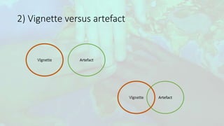
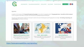
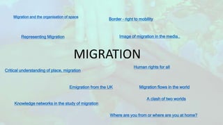
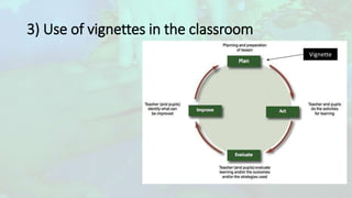
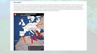
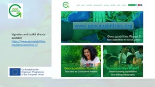
1) The document discusses using "vignettes" in geography education to teach about the topic of migration.
2) It defines a vignette as a brief example or case study that can be used as the basis for a series of lessons on a topic, with teachers continually returning to and expanding upon the vignette.
3) It provides examples of how teachers can design lessons around analyzing different types of vignettes, such as comics, political cartoons, and photos, to develop students' geographical knowledge and thinking skills around the concept of migration.
1. Teaching about migration using
a GeoCapabilities approach
‘vignettes’ as a way for teachers to connect with disciplinary knowledge
Caroline Leininger-Frezal
University of Paris, Laboratory of Didactics André Révuz
Luc Zwartjes
Ghent University, geography department
Sint-Lodewijkscollege Brugge, EUROGEO
IGU-CGE conference Prague 2021
2. SUMMARY
1) Why talking about « migration » ?
2) What is a vignette ?
3) Using of vignettes/artefacts in the classroom
3. 1) Why talking about migration ?
• an area of curriculum commonality across participating partners
• A value-laden contemporary issue dominating aspects of current
social and political discourses in Europe and beyond.
• As a field of enquiry
• A personally relevant topic for many children.
4. 2) What is a vignette ?
• A brief example of PDK in the context of a geography curriculum
• More than a source, build a series of lessons around it, keeps returning,
supplemented with other relevant information.
The best vignettes conceal multiple layers and stories
5. 2) Powerful geographical knowledge
… according the The National Center for Research in Geography Education (NCRGE)
• content-related geographical knowledge,
• conceptual geographical knowledge,
• procedural geographic knowledge, Knowledge thus consists of 'knowing that’ and
two kinds of 'knowing how’. (Winch, 2013)
* Winch, C. (2013) Curriculum Design and Epistemic Ascent, Journal of Philosophy of
Education, 47, 1
6. A ‘Future 3’ curriculum
Three alternative futures or ways of thinking about the school curriculum:
Future 1: "Knowledge for the sake of knowledge", with a lot of factual knowledge in
an often static and conservative curriculum
Future 2: attention shifts from knowledge to learning. attention is paid to learning
and thinking as independent goals of education, regardless of the themes that need
to be learned or thought about
Future 3: This knowledge is dynamic and related to disciplinary concepts and ways of
thinking. It is a curriculum of engagement with professional thinking
It is to enable all students to acquire knowledge that takes them beyond their experience. It is knowledge which many
will not have access to at home, among their friends, or in the communities in which they live. As such, access to this
knowledge is the “right” of all pupils as future citizens Michael Young
7. 2) Vignette versus artefact
An artefact is :
• Document that has been selected because it is a rich source of data and
because it can provoke a response from the students.
Or
• It is created or made, because it needs a knowledgeable and skilful teacher to
see, and then exploit, the full potential of the material.
10. Migration and the organisation of space
MIGRATION
Border – right to mobility
Representing Migration Image of migration in the media..
Critical understanding of place, migration
Emigration from the UK
Human rights for all
Migration flows in the world
Knowledge networks in the study of migration
Where are you from or where are you at home?
A clash of two worlds
13. Teachers design a lesson on
image analysis:
They used :
Comics
Political Cartoons
Photo langage
14. Title: Emigration from the UK
Description:
The chosen topic within migration for this vignette is the issue of emigration from the
UK, exploring the what, where and why for emigrating from the UK. Most teaching
around migration in school is focused on the basic push and pull factors for why people
move to the UK (international migration) or to cities (internal migration). We end up
taking a very Eurocentric approach, highlighting the benefits of living/working in
countries around Europe. But in 2018, 345, 000 people left the UK to go and live
abroad – what about this group of migrants?
The map below shows the numbers and locations of migrants that have emigrated from
the UK. The UN data details 5 million Britons living abroad. Although the image gives a
clear indication of where people are moving to, there is no detail about the reasons why
this may be the case. The idea of place – what places mean to different people, how
they are constructed, how places become homes – helps students to understand why
people emigrate from the UK to other places around the world. By looking just at the
arrows and the numbers we miss the more human side of migration in understanding
motives and the significance of different destinations.
Discussion
To fully understand and interpret the stimulus image, students need an understanding of flows, place, connections and interdependence. As this PDK about migration
shows, people could easily look at the numbers and arrows present on the map and make some reasonable guesses about why people would move from the UK to
the other countries (climate, work, family) – keeping in line with simplified push and pull factors. However, this lack the geographical thinking and analysis of the
image because it does engage with the idea of place and the relationships of people with different places.
Geographic knowledge of both the UK and the nations where emigrants end up is needed to look beyond the push and pull factors. Without a more in-depth
geographical understanding of place, locations and flows, people tend to draw conclusions about migrations on their own personal and everyday experiences (e.g.
why would I want to move to Australia?). This example also requires students to have substantive knowledge about locations/different countries as the basis for
understanding why people would emigrate from the UK. Building on this, students would then develop their geographical thinking in dissecting these locations
further to explore the concept of place and the different ways that places are constructed and experienced by the individual. With this understanding, students can
explore beyond push and pull factors to understanding the driving forces behind international migration and make more informed analyses of global migration
patterns from the UK.
15. Parts of sequence
(e.g. Lesson)
Geographical content & key Qs Intended outcomes (esp. in
terms of PDK)
Learning activity Assessment opportunities
1 What is migration and why
might it be called a crisis?
To give students the language
and understanding of the
concept of migration so that
they can set it in
What do you already know?
Students to look at key Facts
and Definitions.
Students to annotate facts
on map.
Students to use information
in a paragraph.
Initial knowledge –
annotating picture.
Using definitions and facts
in a short paragraph.
2 What is driving migration? To allow students to
understand the cause of
migration.
To look at push and pull
factors.
To read through the
personal stories of
migration and pick out key
reasons.
To plot out using lee’s
model as a template.
Students will produce
annotated diagrams
showing the kep
information from the stories
they have looked at.
3 What is the impact of
migration?
To give students an ability to
look at the impacts of
migration in a balanced and
structured way.
To look at what benefits
migration brings and
impacts of migration.
To consider why some
people might consider
Students will produce a
balanced answer
considering the impacts of
migration.
an area of curriculum commonality across participating partners, thus enabling comparisons across jurisdictions.
A value-laden contemporary issue dominating aspects of current social and political discourses in Europe and beyond,
as a field of enquiry it has strong social justice threads of its own.
a personally relevant topic for many children. Some children are themselves refugees, they may be recent migrants or from second or third generation migrant movements
content-related geographical knowledge, e.g. knowledge and understanding of geographical terminology and content-related concepts such as alluvial plain, metropolitan area, ethnic group, tertiary economy, coniferous forest, geological fault, flood plain, natural hazards, etc.
conceptual geographical knowledge, e.g. using "big ideas" in geography, such as location, place, region, interconnection, spatial relations, etc., to think about people, places and environments, from the local to the global
procedural geographic knowledge, e.g. spatial analysis with a GIS or other geospatial technology, designing a geographic survey and research study, collecting spatial data in the field, etc.
GeoCapabilities uses an important framework to help us think about the established curriculum. This framework distinguishes 'three curriculum futures'.
GeoCapabilities promotes a progressive knowledge programme (Future 3).
Future 1 "traditional": Content as 'given'; a curriculum of 'delivery'.
Future 2 "progressive": Content as arbitrary; a curriculum emphasising generic skills and competences.
Future 3 "progressive": Content is neither 'given' nor arbitrary. It is dynamic and linked to disciplinary procedures and processes. This is a curriculum of engagement with powerful knowledge.