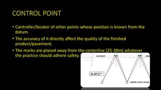
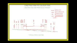
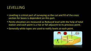
SURVEYING
BASICS APPLIED TO ROAD PROJECTS
CONTROL POINT
• Controller/locator of other points whose position is known from the
datum.
• The accuracy of it directly affect the quality of the finished
product/pavement.
• The marks are placed away from the centerline (25-30m) whatever
the practice should adhere safety.
REESTABLISHMENT OF THE CONTROL POINT
• Computations of coordinates for these new control points shall be
ancillary to the main traverse adjustment so that minor adjustments
to previously fixed points are avoided.
• In bridge construction two control points are needed to line, level and
startup for bridge construction.
CLEARING LINE
• The clearing line is pegged to enable removal of topsoil and
vegetation.
• Pegging is done by offsetting from previously set out string lines,
scaling and measuring from the plan using established features such
as fences, edge of road, cadastral boundary etc.
• Accuracy required for this work is generally 0.5m or as specified by
the contract documents or the project engineer.
LEVELLING
• Levelling is critical part of surveying as the cut and fill of the cross
section for bases is dependent on this part.
• Points elevation are measured as Reduced level with the help of total
station and each point is a rise or fall adjacent to its previous point.
• Generally white tapes are used to notify levels at each point.
MARKINGS
• Spring head nails with colored flags under it are nailed to align for
priming edge and kerbing purposes.
• In case of priming edge seal the alignment should be nailed every
10m with spring head nails and flagging under the nail to ensure that
spray run is on correct alignment and uniform.
• In case of kerbing the intervals between nails should not exceed 15m
on straights and 5m on large radius curves.
LANES MARKING
• Before asphalt paving can proceed, the proposed lane marking has to
be established in order for the asphalt joins to coincide with the line
markings.
• Spotting is done in different manners depending upon the
specification manual and machinery used.
• Use this link to understand how machines use width of the lane for
lane markings. “https://www.youtube.com/watch?v=BeEUb--w1jY”
Surveying

Surveying

  • 1.
  • 2.
    CONTROL POINT • Controller/locatorof other points whose position is known from the datum. • The accuracy of it directly affect the quality of the finished product/pavement. • The marks are placed away from the centerline (25-30m) whatever the practice should adhere safety.
  • 3.
    REESTABLISHMENT OF THECONTROL POINT • Computations of coordinates for these new control points shall be ancillary to the main traverse adjustment so that minor adjustments to previously fixed points are avoided. • In bridge construction two control points are needed to line, level and startup for bridge construction.
  • 4.
    CLEARING LINE • Theclearing line is pegged to enable removal of topsoil and vegetation. • Pegging is done by offsetting from previously set out string lines, scaling and measuring from the plan using established features such as fences, edge of road, cadastral boundary etc. • Accuracy required for this work is generally 0.5m or as specified by the contract documents or the project engineer.
  • 6.
    LEVELLING • Levelling iscritical part of surveying as the cut and fill of the cross section for bases is dependent on this part. • Points elevation are measured as Reduced level with the help of total station and each point is a rise or fall adjacent to its previous point. • Generally white tapes are used to notify levels at each point.
  • 7.
    MARKINGS • Spring headnails with colored flags under it are nailed to align for priming edge and kerbing purposes. • In case of priming edge seal the alignment should be nailed every 10m with spring head nails and flagging under the nail to ensure that spray run is on correct alignment and uniform. • In case of kerbing the intervals between nails should not exceed 15m on straights and 5m on large radius curves.
  • 8.
    LANES MARKING • Beforeasphalt paving can proceed, the proposed lane marking has to be established in order for the asphalt joins to coincide with the line markings. • Spotting is done in different manners depending upon the specification manual and machinery used. • Use this link to understand how machines use width of the lane for lane markings. “https://www.youtube.com/watch?v=BeEUb--w1jY”