The document describes Sichuan Network GPS services including:
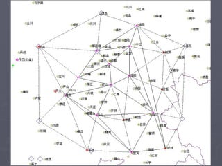
1. A network of 13 reference stations spaced 42-132km apart connected to a central control center
2. The network provides RTK accuracy of ±2.5cm within a 4,500 sq km service area and RTD accuracy of ±33cm within a 36,000 sq km area
3. Evaluations found the network achieves better than specified accuracies with rapid attenuation beyond 50km from the network boundaries


![W(level3) wcdma rno rf optimization-20041217-a-1[1].0](https://cdn.slidesharecdn.com/ss_thumbnails/wlevel3-wcdmarnorfoptimization-20041217-a-11-0-120122084046-phpapp01-thumbnail.jpg?width=640&height=640&fit=bounds)