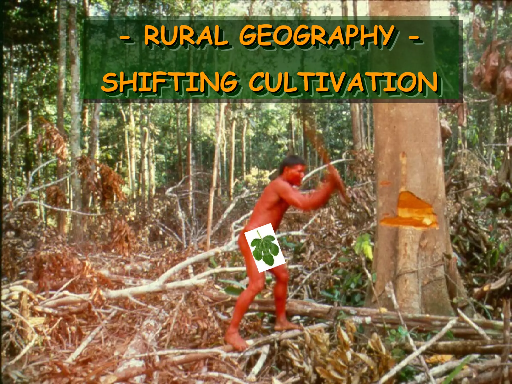
Shifting cultivation, also known as slash and burn agriculture, is a farming method used by over 300,000 people worldwide. It involves clearing areas of forest for crops, which are grown for a few years until soil fertility declines, at which point a new area is cleared. Population densities are very low, around 1 person per square kilometer, due to the dispersed settlement pattern required with frequent field relocation. Crops grown include manioc, maize, bananas, and other fruits and vegetables. After several years of use, fields are abandoned to allow the forest and soil nutrients to recover through natural regeneration.
Organic matter provides numerous chemical, physical, and biological benefits to soil. Chemically, it acts as a reservoir of nutrients, contributes to the soil's cation exchange capacity, and forms chelates that make nutrients more available to plants. Physically, organic matter improves soil structure, increases the soil's water holding capacity, and prevents erosion. Biologically, it supports soil microorganisms that drive nutrient cycling and helps maintain overall soil quality.
Solar radiation provides the energy for key plant physiological processes like photosynthesis. It consists of visible light, infrared, and ultraviolet wavelengths. The quality, intensity, and duration of light impact plant growth. Different plant species have varying responses to light intensities, with some being short day or long day plants. Solar radiation is measured using pyranometers and provides energy for evaporation, heating soils and air, and driving photosynthesis in plants.
This document discusses different forms of water erosion including splash/raindrop erosion, sheet erosion, rill erosion, and gully erosion. It provides details on each process and how they relate to each other in stages from small rills developing into larger gullies over time due to water flow. Additionally, it covers specialized forms of erosion like pedestal erosion and piping erosion as well as classification systems for gullies based on shape, activity level, and size.
This document provides information on soil classification and taxonomy. It describes the major soil orders including Alfisols, Andisols, Aridisols, Entisols, Gelisols, Histosols, Inceptisols, Mollisols, Oxisols, Spodosols, Ultisols, and Vertisols. It also outlines the USDA soil taxonomy hierarchy from order down to soil series and explains the distinguishing characteristics used at each level such as diagnostic horizons, physical and chemical properties, texture, and consistence.
This document discusses erosivity and erodibility. It defines erosivity as the ability of rainfall to cause erosion, which depends on factors like rainfall intensity, amount, and drop size. Two common methods to estimate erosivity from rainfall data are presented: the EI30 index method and KE>25 index method. Erodibility is defined as a soil's susceptibility to erosion, which depends on physical properties like texture, structure, and organic matter. The relationship between erosivity and erodibility is that erosivity depends on rainfall characteristics while erodibility depends on soil properties, and both factors must be considered to understand soil erosion.
Role of Grasses and Pastures, Wind breaks and Shelter belts in soil conserva...Abhilash Singh Chauhan
This document discusses the role of pastures and grasses in soil conservation. It begins by defining pasture and describing the vegetation typically found in pastures. Well-maintained pastures protect soil by maintaining vegetative cover, which reduces the impact of raindrops and absorbs rainfall. The roots and leaves of pasture grasses hold soil in place and block water runoff. Grazing livestock also help nutrient cycling which enriches the soil. Windbreaks and shelterbelts are effective at reducing wind speed and soil erosion through intercepting wind. Even sparse shelterbelts provide shelter over many times their height and significantly reduce wind erosion.
PRINCIPLES OF EROSION: Types of erosion, factors affecting erosion, effects of erosion on land fertility and land capability, estimation of soil loss due to erosion, Universal soil loss equation.
The document discusses 15 key processes involved in soil formation:
1) Humification transforms raw organic matter into humus through decomposition.
2) Laterization concentrates iron and aluminum oxides in tropical soils.
3) Eluviation mobilizes and translocates constituents like clay from top to lower layers.
4) Illuviation deposits translocated materials in lower layers, forming distinct horizons.
India has been divided into 15 agro-climatic regions based on differences in terrain, climate, rainfall and soils. Some of the key regions include the Northern Mountainous region characterized by low temperatures and snowfall hindering agriculture. The Northeastern region includes seven states and is suitable for rice cultivation. The Gangetic plain spans multiple states and is highly productive for crops like rice, wheat and sugarcane due to fertile alluvial soils and favorable climate. The Western Coast receives high rainfall and is suitable for crops like rice and coconut. India's agro-climatic regions show great diversity in crops based on differences in geography and climate.
This document discusses the basis and classification of forest types. It begins by outlining seven bases for forest classification: physiognomy, structure, function, floristics, habitat, physiography, and history. It then describes the four major forest categories: tropical forests, subtropical forests, temperate forests, and northern coniferous forests. For each category, it provides details on location, climate characteristics, and examples of forest types. The document concludes by summarizing Champion and Seth's revised 1968 classification of forests in India, which divides forests into five major groups.
The Universal Soil Loss Equation (USLE) is a widely used method for estimating average annual soil loss. It was initially proposed in 1958 and modified to its current form in 1978. The USLE estimates soil loss as a function of rainfall erosivity, soil erodibility, slope length and steepness, crop management practices, and conservation support practices. It is used to predict soil loss, guide crop and management selections, and determine conservation needs. However, the USLE is empirical and only estimates average annual soil loss from sheet and rill erosion without considering sediment deposition.
Soil erosion is the displacement of topsoil from its original location. It occurs naturally but can be exacerbated by certain human activities like deforestation, farming practices, lack of vegetation, and wind. The erosion process involves three steps: detachment of topsoil, movement of topsoil to another area, and deposition of topsoil in the new area. Major causes of soil erosion include rain and rainwater runoff, farming, slope of the land, lack of vegetation, and wind. Effects of soil erosion are loss of fertile topsoil, soil compaction, reduced organic and fertile matter, and issues with plant reproduction. Solutions to soil erosion include careful tilling, crop rotation, strip farming, shelter belts, contour pl
The document discusses biological soil conservation methods. It describes several methods such as contour farming, crop rotation, strip cropping, choice of crops, mulching, cover crops, reforestation, mixed crops, and wind breaks. These biological methods help maintain soil cover and reduce erosion by decreasing runoff, increasing infiltration, and reducing the velocity of water flow. The methods are effective because they are low cost and protect the soil through different planting techniques and crop choices that sustain soil productivity and quality over time.
The document discusses watershed management. A watershed is an area of land that drains water to a common point such as a river, lake, or ocean. Factors like soil type, vegetation, and terrain influence how quickly water drains within a watershed. Watershed management is important for sustainable development as it helps manage water resources, recharge groundwater, and increase food production and livelihoods. Benefits of watershed management include water collection and supply, flood prevention, employment opportunities, and potential for tourism.
This document discusses waterlogged soils, their properties, distribution, impacts on agriculture, and management strategies. It defines waterlogged soils as soils that are saturated with water for long periods annually, resulting in distinct soil layers. Common types include riverine flood, oceanic flood, seasonal, perennial, and sub-soil waterlogging. Factors like rainfall, irrigation, drainage, topography, and groundwater levels can lead to waterlogging. The document then outlines the physical, chemical, and biological properties of waterlogged soils. It also discusses the global distribution of waterlogged soils and some major regions before detailing approaches to manage waterlogging issues in agriculture.
This document discusses different tillage practices and their effects. Conventional tillage destroys soil structure and is more costly due to rising fuel prices, leading to recommendations to change to minimum tillage. Minimum tillage aims to reduce tillage to the minimum needed for seedbeds while improving soil conditions. Studies show minimum tillage increases yields compared to conventional tillage and improves soil properties like structure and infiltration. No-till and stubble mulch tillage practices, which leave crop residues on the soil surface, provide further benefits like increased nutrient availability and moisture conservation.
Presented by IWMI's Ian W. Makin and Herath Manthrithilake at the INWEPF (The International Network for Water and Environment in the Paddy Field) Symposium 2015 Symposium held on November 3, 2015, in Negombo, Sri Lanka.
NAME : MANZOOR NABI
COURSE : B.SC (FORESTRY)
(Semester- v)
Year:-2015-16
student at mewar university Rajasthan, India
TOPIC: SHIFTING CULTIVATION
SUB : AGROFORESTRY
CONTACT ME.........
E-mail:- manzoornabi57@gmail.com
This document provides definitions and terminology related to range management. It begins with definitions of rangeland and range management, emphasizing that range management uses ecological principles to manage grazing lands for various purposes like livestock grazing, wildlife habitat, and recreation. The document then lists and defines over 50 terms used in range management, including types of plants, vegetation measurements, grazing systems, and land classifications. It provides context and examples for many terminology entries.
This document discusses the Universal Soil Loss Equation (USLE). The USLE estimates soil loss from sheet and rill erosion in tons per hectare per year. It is represented by the equation A=R×K×L×S×C×P, where A is the computed soil loss, R is the rainfall erosivity factor, K is the soil erodibility factor, L and S are the slope length and steepness factors, C is the cover management factor, and P is the support practice factor. The document describes the methodology used to calculate each factor in the USLE and discusses some limitations of the model, such as not accounting for gully erosion or sediment deposition.
ROLE OF AGROFORESTRY IN MITIGATION OF CLIMATE CHANGEGANDLA MANTHESH
This document discusses the role of agroforestry in mitigating climate change. It begins by defining climate change and its causes, then outlines some of the impacts on agriculture like reduced crop yields. It notes that deforestation and land use changes contribute significantly to greenhouse gas emissions. The document then discusses strategies for carbon sequestration, identifying agroforestry as a key approach. Various agroforestry models are presented, and a case study shows higher carbon storage in a silvopastoral system compared to natural grassland. The conclusion is that agroforestry can significantly help mitigate climate change by storing carbon while providing other benefits.
This document discusses dryland agriculture, which refers to growing crops entirely through rainfall. It can be divided into dry farming (<750mm rainfall), dryland farming (750-1150mm rainfall), and rainfed farming (>1150mm rainfall). Dry farming occurs in arid regions and has frequent crop failures due to low and variable rainfall. Dryland farming occurs in semi-arid regions and has less frequent crop failures. Rainfed farming occurs in humid regions and has rare crop failures. The document also discusses various irrigation techniques like surface, localized, and subsurface irrigation that help supplement rainfall for crop growth.
This presentation includes description about water erosion, types of water erosion i.e. Raindrop erosion, Sheet erosion, Rill erosion, Gully erosion, Stream bank erosion, Sea-shore erosion Landslide/ slip erosion and Tunnel erosion.
This document discusses the importance of drainage in irrigated agricultural areas. It defines drainage as the removal of excess water from soil. Excess water can come from heavy rainfall or over-irrigation and can cause waterlogging of soils. Waterlogging deprives plant roots of oxygen and can lead to increased soil salinity. The document outlines various causes and effects of waterlogging and describes different types of drainage systems including surface drainage, subsurface drainage, vertical drainage, well drainage, controlled drainage, bio-drainage and their characteristics and advantages. Research on the impact of subsurface drainage in reclaiming waterlogged salt-affected soils in Andhra Pradesh, India is summarized which shows that drainage reduces soil salinity and increases crop yields.
This document discusses various types and causes of soil erosion. It defines soil erosion as the wearing away and transportation of soil by water, wind or other forces. The main types discussed are normal erosion, accelerated erosion, wind erosion, water erosion, landslides, and stream bank erosion. Water erosion is further broken down into splash erosion, sheet erosion, rill erosion, gully erosion, and stream erosion. The document also discusses factors that affect erosion like energy/erosivity, soil resistance, and protective measures. It outlines on-site and off-site effects of water erosion such as reduced crop yields, loss of nutrients, and water pollution.
2,4-D was first synthesized in the 1940s by W.G. Templeman at Imperial Chemical Industries as a herbicide to kill broad-leaved weeds without harming cereal crops. In the 1950s, the triazine family of herbicides including atrazine were introduced but atrazine does not readily break down and can contaminate groundwater, especially under alkaline soil conditions. Glyphosate was introduced in 1974 for non-selective weed control and is now widely used with glyphosate-resistant crops.
This document provides information about dryland farming and drought management strategies. It defines dryland farming as crop cultivation under rainfed conditions with annual rainfall less than 750 mm. It notes that about 70% of India's rural population lives in dryland farming areas. The document discusses various climatic and soil constraints to crop production in dryland regions such as variable rainfall, high temperatures, and low soil moisture and fertility. It also describes different types of drought based on duration and impact. The document concludes by outlining some strategies for drought management, including adjusting plant populations, mulching, water harvesting, and adopting alternate land use systems.
This document discusses different types of soil erosion, factors that affect erosion, and conservation practices to reduce erosion. It describes geological erosion as natural soil-forming processes, while accelerated erosion is soil loss due to human activities. Water erosion is divided into raindrop, sheet, rill, gully, and stream channel erosion. Major factors affecting erosion by water are climate, soil properties, vegetation, and topography. Conservation practices discussed include contouring, strip cropping, and tillage management.
The document summarizes five main types of agriculture in less developed countries: 1) Shifting cultivation, where land is cleared and burned for crops for a few years before being abandoned; 2) Pastoral nomadism, which relies on herding animals in arid regions; 3) Intensive subsistence wet rice farming, common in Asia near rivers; 4) Intensive subsistence non-wet rice farming, growing crops like millet and wheat; and 5) Plantation farming, where commercial crops are grown on large estates for export.
Shifting cultivation involves clearing and burning forest areas for temporary agriculture, leading to deforestation, erosion, desertification, and loss of biodiversity as forests are destroyed. However, it also benefits the environment by recycling nutrients into used land, improving sustainability, and providing organic pest management. The challenges are balancing these adverse impacts with the environmental benefits of the practice.
Shifting Cultivation & Its Alternatives for Sustainable AgricultureNurIbneShamsTuhin
Shifting cultivation (SC), also known as slash and burn agriculture, is the most common form of cultivation in the Chittagong Hill Tracts of Bangladesh. However, decreasing fallow periods from 15-20 years to 3-4 years has led to significant environmental impacts like soil erosion, deforestation, and loss of wildlife. While shifting cultivation is important for local communities, more sustainable modern methods like hedgerow planting, terracing, and geo-jute technology can help minimize these impacts by improving soil and water conservation. The introduction of alternative livelihoods is also needed to reduce pressure on agricultural land.
The document discusses different types of agriculture including shifting cultivation, wet rice cultivation, plantation agriculture, and high-tech farming. Shifting cultivation involves clearing small plots of land and farming them until the soil becomes infertile, then moving to another plot. Wet rice cultivation is practiced in Asia and involves growing rice in flooded terraced fields. Plantation agriculture grows cash crops like oil palm on large estates. High-tech farming uses advanced technology like hydroponics, aeroponics, computers and machinery.
This document provides an overview of biodiversity, including its definition, types, distribution, benefits, threats, and conservation. It discusses how biodiversity represents the variety of life on Earth and is vital to sustaining human life. The three types of biodiversity are genetic diversity, species diversity, and ecosystem diversity. While biodiversity is threatened by habitat loss and other human impacts, conservation efforts aim to protect biodiversity through protected areas, restoration, and environmental policies.
Fisherman’s participation in assessing level of sustainable livelihood in sur...Alexander Decker
This document summarizes a study on assessing the level of sustainable livelihoods among fishermen in the coastal city of Surabaya, Indonesia. The study used the Sustainable Livelihoods Approach (SLA) and participatory poverty assessments (PPA) to evaluate fishermen's access to key assets: human, social, natural/environmental, physical, and financial. The results showed fishermen had good access to physical infrastructure but poor access to other assets. For example, over 60% lacked education beyond elementary school and only 20-35% were actively involved in social or economic organizations. Additionally, many lacked secure land rights and natural resources like mangroves were being degraded. The overall level of sustainable livelihood was
Shifting cultivation, also known as slash and burn agriculture, is practiced in equatorial rainforest regions globally. Groups of 20-50 people clear areas of forest using fire, then cultivate crops for a few years before abandoning the plots to allow regeneration. The practice is sustainable if land is left fallow, but is threatened by deforestation, population growth, and commercial exploitation of forests.
Presentation For the Science for Impact- Building The Critical Mass. Workshop Facilitated by CTA and Jointly Organized by UNRE, NARI and USP School of Agriculture and Food Technology, Samoa
Theme 3. Producing the Kinds of Graduates Required.
Willie Maso presented papers describing how the University of Natural Resources and Environment (UNRE) programmes enable students to acquire the skills and confidence to manage available resources to the extent of managing their own or community farming enterprises. The emphasis is on student participation, hands-on involvement and responsibility. This echoed the Vice Chancellor’s theme of training for job creation, not just training for a job. So far UNRE does not have the problem experienced elsewhere of attracting good students into agriculture and fisheries
Lesson 3 Kayapo And Shifting Cultivationgeographypods
The indigenous people of the Amazon rainforest practice a sustainable method of shifting cultivation. They clear small areas of land by cutting down trees and burning them to create space for growing crops. After several harvests, as the soil nutrients are depleted, they move to new areas to farm and allow the previous areas to recover for around 50 years. However, increased commercial development in the Amazon has reduced available land, forcing the indigenous people to return to areas before they have fully recovered. They are also threatened by diseases they have no immunity against. The document also warns about the candiru fish, which can swim into and latch inside the human urethra, requiring surgical removal.
1. Pastoralism is a subsistence system based on raising livestock in arid, marginal lands not suitable for agriculture. Pastoralists rely primarily on animals for food, including meat, milk, and blood.
2. Pastoralist societies are often organized into tribes and lineages, with the household and extended family as the basic social units. Younger members tend livestock while women are responsible for cooking, milking, and other domestic tasks.
3. Traditionally, pastoralist diets consisted mainly of meat, milk, and blood from livestock. However, changing circumstances have led most pastoralists to incorporate more grains and vegetables into their diets to improve nutrition. Environmental and social changes also enable pastoralists to
Pros and cons of community based natural resource management.Dr. Pauline Gitonga
This document summarizes key principles of successful community-based natural resource management (CBNRM) projects based on case studies from several countries in Africa. It finds that CBNRM projects are most likely to succeed when they (1) involve local communities in decision-making and provide direct economic benefits, (2) establish clear incentives for sustainable resource management, and (3) recognize traditional community structures and communal ownership of resources. The document analyzes examples of successful CBNRM projects in Malawi, Zimbabwe, and Namibia that demonstrate these principles. It also examines some cases of CBNRM projects that failed due to a lack of clear benefits, leadership issues, or not incorporating local social norms.
This document provides an overview of community-based natural resource management (CBNRM). CBNRM combines conservation objectives with generating economic benefits for rural communities through collective management of natural resources. It aims to involve local communities in sustainable resource use and management. The document discusses key CBNRM principles, benefits and challenges, and provides examples of CBNRM case studies in South Africa. It also outlines some opportunities for applying CBNRM approaches in Mongolia.
Strategies for sustainable managemnet of degraded coastal land and water for...P.K. Mani
This document summarizes a project aimed at enhancing productivity of degraded land and water resources in coastal regions through integrated approaches. Key activities included land shaping, pond excavation, crop diversification, integrated nutrient management, and farmer training. Baseline surveys assessed initial soil and water quality across 3 villages. Monitoring found that land shaping and pond excavation reduced soil salinity and improved drainage. Crop diversification increased household incomes, employment, and nutritional levels. Training programs empowered over 800 farmers in topics such as vermicomposting, livestock health, and fish cultivation. The project developed environmental and social frameworks to maximize benefits and mitigate negative impacts.
Subsistence Farming In The Developing Worldbriandv
Subsistence farming is a form of farming where farmers grow crops and raise livestock primarily for their own consumption rather than for trade or sale. Historically, subsistence farmers would move from place to place to farm and find new land. While this was the dominant farming method for centuries, industrialization and colonization led to the rise of commercial farms. Today, subsistence farming is still practiced in remote parts of the world that were not converted to commercial agriculture. Subsistence farmers employ techniques like terracing, crop rotation, and using animal waste as fertilizer to sustainably produce enough food for their needs on the land available to them.
This document discusses subsistence farming, which provides a sustainable source of food for families or communities. There are two main types - family-based small farms where all produce goes to the immediate family, and community-based somewhat larger farms where most produce is used by the community. Subsistence farms are found in impoverished areas where they support families barely getting by, and also in developed nations where money plays a larger role. Key methods used include intercropping to maximize space, composting to improve soil, and chickens to fertilize land. Water is obtained through rain barrels or natural wells. Some farms earn income through CSAs or farmers markets.
Plastic bags are negatively impacting the environment through landfill waste that does not biodegrade and pollution of rivers and oceans that harms marine animals. The document discusses alternatives to plastic bags, their benefits and disadvantages, as well as conducting a local survey to understand community views on plastic bags and alternatives in order to determine appropriate next steps.
This presentation tells about the forest rights acts and highlights the issues in it's implementation, Aid for change work address the underlying issues and its impact on the community
This document compares and contrasts intensive and extensive farming. Intensive farming uses high amounts of inputs like capital, labor, pesticides, and fertilizers on small areas of land to achieve very high outputs. It is characterized by large numbers of animals raised in confined spaces. Extensive farming uses low inputs on large areas of land, as seen with grazing of animals on grasslands. While intensive farming yields more per hectare, extensive farming requires less labor per unit area. Both approaches have environmental impacts and trade-offs between productivity and resource use.
The document discusses ecosystems and communities. It defines succession as the regular changes in community structure over time. Succession can be primary, starting with no organisms, or secondary, starting with a disturbed existing ecosystem. Biomes are large terrestrial climax communities determined primarily by climate factors like temperature and precipitation. Major biomes described include deserts, grasslands, savannas, rainforests, and forests. Aquatic ecosystems are shaped by factors like water depth, temperature, and salt content, and include estuaries, lakes, rivers, and oceans. Human impacts like agriculture, logging, and pollution are discussed for many ecosystems.
GEOGRAPHY IGCSE: TROPICAL RAINFORESTS. DEFORESTATION ON THE AMAZONGeorge Dumitrache
GEOGRAPHY IGCSE: TROPICAL RAINFORESTS. DEFORESTATION ON THE AMAZON. It contains: tropical rainforests, average rainfall in Brazil, rainforest ecosystems, disadvantages of human intervention, rainforest water cycle, rainforest nutrient cycle, rainforest soils, vegetation layers, fan palms, buttress roots, lianas, strangler figs, case study, humans and the Amazon.
Tropical rainforests are located in warm, equatorial regions like South America, receiving high average rainfall of 108 inches per year. They have immense biodiversity, being home to over 427 mammal, 1,300 bird, and 400 amphibian species. The document describes some animal species found in rainforests like anacondas, glass frogs, macaws, sloths, and jaguars. It also discusses plant species like corpse flowers, strangler figs, and Amazon water lilies. Food webs and pyramids in rainforests are explained, showing energy transfer between primary producers, primary consumers, and apex predators. Photosynthesis occurs most actively in the canopy layer. Deforestation is an issue
The tropical rainforest is a unique ecosystem with constant high temperatures and rainfall. This creates a unique water and nutrient cycle. However, rainforests are threatened by human expansion and activities like agriculture, mining, and infrastructure development which can lead to deforestation and environmental degradation. While these activities may provide short-term economic benefits, they often come at the cost of significant environmental damage and loss of biodiversity.
The taiga biome, also known as boreal forest or snow forest, is located in northern high latitudes between tundras and temperate forests. Soils are nutrient-poor due to cold temperatures that slow decomposition. Characteristic plants include coniferous trees like spruce and pine, along with ferns and berries. Though conditions are harsh, the taiga supports a diversity of animal life including brown bears, wood bison, Canadian lynx, and Siberian tigers. Nutrients cycle slowly through the food web from trees to primary consumers like deer, then to secondary consumers and top predators. Human impacts include logging, fur trapping, oil extraction, and climate change, which threaten biodiversity and the future
Tropical savannas have distinct seasonal patterns of rainfall and temperature. They experience wet summers and dry winters with annual rainfall around 30 inches. Located near the equator, savannas have high biodiversity and nutrient turnover in the soil. A variety of large herbivores and predators live in savanna ecosystems, and have adaptations like stripes, trunks, and camouflage to survive. Grasses and trees in the savanna also have adaptations like deep roots and water storage to endure dry periods. The rapid nutrient cycling and high primary productivity in savannas supports complex food webs and a great abundance of animal life. However, human impacts like poaching, overgrazing, and population growth threaten
The document defines and describes grassland and chaparral biomes. It identifies the group members and their objectives of defining, classifying examples, identifying biotic and abiotic factors, determining climate, and assessing human impacts and solutions. It provides details on temperate and tropical grasslands, including examples in the Philippines. Characteristics of prairies and savannas are described. The chaparral biome is also characterized and its biotic organisms, abiotic factors, seasons, soil, human impacts and potential solutions are outlined.
The document provides an overview of the Amazon rainforest, including its location, structure, climate, inhabitants, resources, importance, threats from deforestation, and conservation efforts. Specifically, it notes that the rainforest spans many South American and African countries near the equator, contains many layers of vegetation up to 70 meters tall, has a warm, humid climate without distinct seasons, and is an important source of oxygen, water, minerals, and biodiversity for the planet. However, deforestation from agriculture, logging, pollution, and other abuses threatens this critical ecosystem, though some national parks like Manu's Park in Brazil are working to protect endangered species and rescue the rainforest.
What is a Desert?What is Desert Ecosystem?Types of desert,A Desert’s Characteristics ,Climate,Animals,Endangered Animals ,Plant Life of Deserts ,seasons,Adaptations,Human effects,Structure & Functions,Flora,Fauna,Environmental threats to deserts,major deserts,The ten largest deserts .
This document summarizes key aspects of tropical rainforests, including their location, climate characteristics, soil type, vegetation layers, threats, and causes of deforestation. Tropical rainforests are located between 5-10 degrees north and south of the equator in countries like Brazil, Indonesia, and the Amazon Basin. They have high temperatures, rainfall, and humidity that support the growth of deep, nutrient-poor soils and several vegetation layers ranging from emergent trees to an understory. Common threats include slash-and-burn agriculture, fires, logging, cattle ranching, and agriculture which have significantly reduced tropical rainforest coverage due to unsustainable practices.
The document summarizes the major terrestrial biomes of the world. It describes the six biomes as: 1) Desert biome, which is characterized by hot and dry climates with less than 10 inches of rain per year. Common plants include cacti and animals have adaptations for heat and lack of water. 2) Tundra biome, which is located north of the Arctic circle and is the coldest biome with less than 25 inches of rain per year. Plants are low growing and animals have thick fur. 3) Taiga biome or boreal forest, located in northern parts of North America, Asia, and Europe. It has long, cold winters and coniferous trees are abundant. 4) Rainforest biome
The document summarizes the major terrestrial biomes of the world. It describes the six biomes as desert, tundra, taiga (boreal forest), tropical rainforest, grasslands (including savanna), and temperate deciduous forest. For each biome, it provides information on location, climate, vegetation, animal adaptations, threats, and examples. It discusses the distinguishing characteristics, climates, plant and animal adaptations, and types of each biome.
The document describes the different biomes found in South Africa, including desert, forest, scarp forest, fynbos, grassland, Nama Karoo, savanna, succulent karoo, and thicket biomes. Each biome is characterized by its dominant plant life and climate. The desert biome experiences summer rainfall and annual grasses. Forests occur where rainfall is over 525mm and are dominated by evergreen trees. Fynbos is located in the Cape Floristic Region and contains a high diversity of plant species. Grasslands experience regular burning and are dominated by grasses and geophytes.
This document provides an overview of ecosystems and communities, including succession, biomes, and major aquatic ecosystems. It discusses primary and secondary succession, describing how pioneer species establish and are replaced over time until a climax community develops. Biomes are described as terrestrial climax communities defined by climate, especially temperature and precipitation patterns. Examples included are deserts, grasslands, savannas, Mediterranean shrublands, tropical dry forests, and tropical rainforests. The impacts of human activities on these ecosystems are also summarized.
The tropical rainforests are located near the equator and experience high temperatures and heavy rainfall year-round. However, rainforests are being cut down at alarming rates for agriculture, settlements, ranching, logging, mining, dams, and roads. This widespread deforestation is harming the environment by causing soil erosion, accelerating global warming, and threatening countless species with extinction. Global warming occurs as fewer trees convert carbon dioxide to oxygen, trapping more heat in the atmosphere. Continued deforestation may worsen problems like melting glaciers and rising global temperatures.
This document provides information about different ecosystems around the world, including cold environments, tropical rainforests, and the Amazon rainforest. It discusses the key components of ecosystems like producers, consumers, and decomposers. Regarding tropical rainforests, it describes their structure, climate, soils, plant and animal adaptations, and importance. For the Amazon, it outlines causes of deforestation like cattle ranching, impacts such as loss of biodiversity and soil erosion, and approaches to sustainable management including REDD+ programs and government schemes.
Tropical rainforests are located between the Tropics of Cancer and Capricorn, in Central and South America, western and central Africa, western India, Southeast Asia, New Guinea, and Australia. Temperatures in tropical rainforests range from 70 to 85°F and do not vary much between day and night. Tropical rainforests contain an extremely high level of biodiversity, with estimates of species ranging from 3 to 50 million, and one hectare can contain over 800 tree species and 1,500 plant species. Tropical rainforests are at risk of being destroyed, with over half already gone, and experts estimate they could be gone within 100 years if destruction continues at the current rate, primarily
The document discusses the Amazon Basin, which is located in Brazil and neighboring countries in South America. It has a tropical climate that is hot and wet year-round. The landscape is dominated by dense rainforest containing a vast diversity of plant and animal species. Indigenous tribes live sparsely in the basin, practicing subsistence farming and shifting cultivation due to the remote location and poor soils. The native people fish, hunt, gather fruits and vegetables for survival.
2. Main learning outcomes: you
should…
• be able to describe the main features of
this type of farming, including the crops
grown, the level of technology used and the
main activities throughout the year.
• be able to describe and explain the
settlement pattern and the population
density.
• be familiar with the changes occurring in
areas of shifting cultivation and the impact
of these changes on the people and the
landscape.
3. INTRODUCTION
One of the most primitive form of farming found
on the earth, Shifting Agriculture still supports
over 300 thousand people.
This type of farming has probably existed for over
10,000 years and was once very widespread – even
found in stone-age Europe.
Largely replaced by sedentary or fixed farming, it is
now in danger of disappearing altogether. It is now
found mainly in equatorial rainforest areas.
4. Tropic of Amazon Centra Indonesia
Cancer Basin l Africa and PNG.
Equator
Tropic of
Capricorn
Global Distribution of Shifting Cultivation
5. Around the World…
• Shifting cultivation is also known as:-
• Slash and Burn;
or
• Ladang (Malaysia)
• Roca (Brazil);
• Masole (Congo)
• Milpa (Mexico)
• This presentation looks at examples from
the Amazon Basin and Papua New Guinea
6. Types of Shifting Cultivation
• Shifting Cultivation proper;
• Permanent village, shifting cultivated areas;
• Rotational bush fallowing.
7. Shifting Cultivation proper…
• Shifting Cultivation in its purest form, clearings
are made in the forest, used for two to five years
to grow food, then abandoned and a new clearing
created. This is repeated, with the village
eventually returning to the original site after 25
years or more – or maybe never.
• Such frequent moves are necessary because the
soil quickly loses its fertility and crops will start
to fail after only a few years.
• Abandoned clearings will be reclaimed by the
forest and gradually the soil fertility will recover.
9. …permanent village, shifting
cultivation
• This variation is probably more common, particularly
in Africa.
• In this system, the village remains in one place and
the farmed clearing is changed every few years.
The old clearing is left “fallow” or rested.
• This system is found where the population is
permanent, the total land available may be less and
where population densities may be higher.
11. …rotational bush fallowing
• As population pressure increases and the amount of
available land decreases, the land around the
village is used continuously.
• This often leads to rapid exhaustion of the soil,
particularly if animal manure or other fertilisers
are not used.
12. …rotational bush fallowing
Continuously cultivated
area around village
1
6 2 Outer clearings
farmed in rotation
Village
5 3
4
13. Population Density and Settlement
Pattern
Because of the large
The settlement required
area of forest pattern
with is dispersed or
all of these moves,
scattered.
the overall population
density is very low –
often less than 1 person
per sq.km.
14. The Climate
• Most shifting cultivation is found in areas of
Equatorial climate.
• Here the sun is overhead, or almost overhead
for the whole year, bringing consistently high
daily temperatures.
• The typical daily weather pattern is of
increasing humidity and heavy afternoon
thunderstorms, caused by convectional rain.
15. Climate Graph for Iquitos, Amazon Basin, Peru (3½ ºS)
Climate Graph for Iquitos, Amazon Basin, Peru (3½ ºS)
350 30
300
25
250
20
This combination of
Rainfall is abundant all Temperature is high all
Rainfall (mm)
200
Temp.ºC
year, with most areasand moisture
warmth year – above 25º C – and 15
receiving creates twelve monthsvery little from
around varies
150
2000mm annually - growingmonth to month.
of perfect
about the same as the for plants –
conditions 10
100 west of Scotland!
Rainforest is the result
5
50
0 0
J F M A M J JL A S O N D
Months
17. Main features…
• This is subsistence farming – only providing enough
for the group, with little or nothing left to sell.
• It is extensive farming i.e. it covers a large area of
land;
• The technology level is very low – all work is done
by hand, with only a few basic tools.
• This type of farming is sustainable or eco-friendly –
it does no lasting harm to the forest environment,
as long as the clearings are given enough time to
recover their fertility.
18. In the top diagram the fallow period is long enough to allow the soil to
recover its nutrients: in the lower one the land is returned to farming
too soon and it quickly loses its fertility.
19. A
Here we see a communal Yanomami house
(Maloca) in a rainforest clearing…
20. Such settlements
usually house about
20 – 100 people.
Many of these
groups have had no
contact with the
modern world.
21. A Boro tribe Maloca A Guarani tribe version
The design varies between different tribal groups…
22. In Papua New
Guinea a house is
built in a few
hours…
The final roof
covering goes
on…
26. Two members of the Mati tribe (cat people)…only
recently “discovered” by the outside world.
27. Although they may look
a bit primitive to us,
these people are able to
live in a very tough
environment, where soft
westerners like us
wouldn’t last long.
…some Mati boys go to
school - part of a
government development
programme for the
native Amerindian
tribes.
31. ..the cut down trees are allowed to dry for three
months or so, then burned, in small, controlled fires.
32. Ground clearance is very hard work, so many
stumps, branches and roots are left.
33. The burned wood adds ash (a natural fertiliser) to the soil.
34. However, the torrential rains cause rapid leaching
Unless the land is left fallow (rested) to recover
of the already poor soils, washing vital minerals
these nutrients, it will be permanently degraded.
out of the soil and reducing its fertility. This is
why the clearings are only used for a few years.
LEACHING by rain.
35. In this Chagra,
a garden rather
than a field,
maize seeds
are being
planted
amongst Sweet
Potato (Papua
New Guinea).
41. Maize (corn) may be
grown where the soils
are richer.
Papaya and other
fruits form an
important part of
the diet.
42. Sugar cane may sweeten
an otherwise bland diet.
Banana provides
important minerals such
as Potassium
43. Other crops may include…
• Yams
• Tobacco
• Coca
• Mangoes
• Beans
Domesticated animals such as pigs and chickens may also
be kept.
44. Meat is usually
hunted in the forest
… monkey, tapir..
The forest also supplies the
people with fruit, berries,
medicines, poisons and
drugs...and, of course, fish
from the rivers add
important protein.
45. After a few years, the crops start to fail and
the clearing is abandoned – to be reclaimed by
the forest.
46. Changes 1
• Shifting cultivation is in danger of disappearing;
• This is due to destruction of large areas of the
rainforest on which this system depends – the area
available is rapidly shrinking;
• This is caused by logging companies, cattle ranchers,
gold, diamond and other mineral hunters & miners, HEP
schemes, road building e.g. Trans Amazon highway and
new settlers moving in to the forest;
• Population growth is also putting additional strain on
this way of life – particularly in west Africa.
47. Changes 2
• Some Indian groups have been forced into
reservations or retreated into more remote areas
deep in the forest;
• many tribes have suffered from Culture Shock;
• There has been violence and intimidation against
these tribes, with many thousands killed by new
settlers;
• Thousands have also died due to lack of immunity to
“western” diseases such as measles;
• There has been serious water pollution by gold mining,
which uses toxic substances such as mercury. This
has caused poisoning of rivers and people.
48. In Brazil, for
example, the
building of the
Trans Amazonian
Highway has
opened up the
virgin rainforest to
settlement and
exploitation, often
with disastrous
consequences for
the shifting
cultivators.
49. Massive deforestation is removing the habitat
on which shifting cultivation depends, as here
in Brazil.
50. Huge fires now destroy
enormous areas in a few hours.
Shifting cultivation is
abandoned and replaced by
large, often foreign owned
schemes.
51. …such as the Jari Project in the 70s and 80s, with its
forestry plantations, cattle ranches, towns and railway lines.
52. Thousands of
garimpeiros, or
gold miners,
devastate an area
of rainforest in a
desperate search
for gold.
53. Review of Main points
• Shifting Cultivation is also known as slash and burn;
• It is found mostly in the equatorial rainforest areas of
the world e.g. Amazon, Congo, PNG.
• It has several versions, including bush fallowing;
• It is low technology;
• It supports a very low population density;
• Its settlement pattern is dispersed;
• It is subsistence farming, with little surplus;
• It is under threat due to a combination of outside
influences. Detailed knowledge of these forces of
change is essential.
54. Important Terms
• Slash and burn
• Ash for fertiliser
• Subsistence farming
• Maloca - house
• Chagra - garden
• Manioc, Sweet Potatoes, Banana
• Leaching of soil
• Fallow period
• Eco-friendly / sustainable