Download as PDF, PPTX


![References
• [1] http://www.unescap.org/sites/default/files/2.12.India_.pdf
• [2]World Health Organization (WHO).2004.World Report on Road Traffic Injury Prevention
Washington, DC.
• [3 ] Haddon, W. 1972. A Logistic Framework for Categorizing HighwaySafety Phenomena and
Activity.
• [4 ] The Journal of Trauma, Vol. 12, Lippincon Williams and Wilkins, Washington, DC, pp. 193-207
• [5] Expert Group Meeting on Progress in Road Safety Improvement in Asia and the Pacific, 8-10 May
2013, Seoul, Republic of Korea. Retrieved from:
http://www.unescap.org/ttdw/common/Meetings/TIS/ EGM-Roadsafety-2013/ppt/4.2.KEC.pdf
• [4] Global Plan for the Decade of Action for Road Safety 2011-2020,United Nations, New York.
Retrieved from: http://www.who.int/roadsafety/decade_of_action/plan/plan_english.pdf
• [5] Zegeer C. V., Reinfurt W., Hummer J. Herf L. and Hunter W. 1988. Effect of Lane and Shoulder
Width on Accident Reduction on Rural, Two-Lane Roads. Transportation Research Record. Vol. 806.
Transportation Research Board. Washington, DC.
• [6] Zegeer C. V., Deen R. C., and Mayes J. G. 1981. Safety Effects of Cross-Section Design for Two-
Lane Roads. Transportation Research Record. Vol. 1195.Transportation Research Board.
Washington, DC
5/8/2016 17KSCST](https://image.slidesharecdn.com/roadaccidentpronesitedetection-160508142906/75/Road-accident-prone-site-detection-17-2048.jpg)


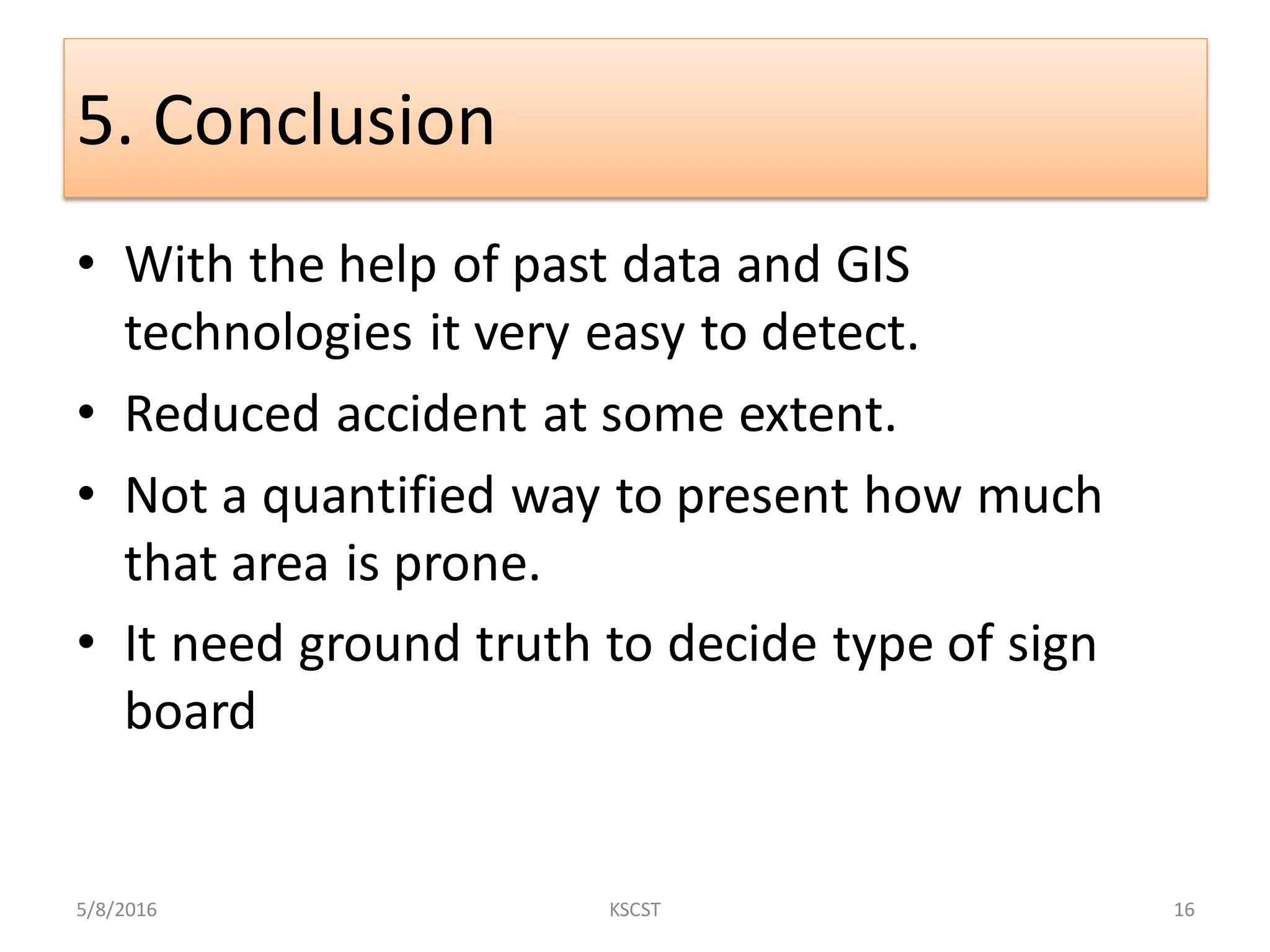
The document discusses a project aimed at detecting road accident-prone sites using geospatial technology, with a focus on methodologies involving GIS technologies and past accident data. It outlines the objectives, methodology, and conclusions regarding the identification of high accident density regions and the implementation of appropriate signage to enhance road safety. The findings suggest that while the approach aids in detection, it requires further validation through ground truth assessments.


![[DSC Europe 25] Danica Soc - The Science Behind Marketing: Experimentation me...](https://cdn.slidesharecdn.com/ss_thumbnails/c0nofsggs9gw5ucmallr-3-251216103155-56bd64d1-thumbnail.jpg?width=640&height=640&fit=bounds)
![[DSC Europe 25] Debmalya Biswas - Agentification: the art of transforming man...](https://cdn.slidesharecdn.com/ss_thumbnails/r5azlggvtqiaiiusrqdr-4-251212103249-5a12c89b-thumbnail.jpg?width=640&height=640&fit=bounds)
![[DSC Europe 25] Behzad Hosseini - AI Agents in the Wild: Deploying Models tha...](https://cdn.slidesharecdn.com/ss_thumbnails/3qtejajvsjqrzwfept2c-10-251212103250-7f2b1068-thumbnail.jpg?width=640&height=640&fit=bounds)
![[DSC Europe 25] Uros Pesic - The Reality of AI in Marketing.pdf](https://cdn.slidesharecdn.com/ss_thumbnails/rtkodnmtycovsllvzsyn-9-251215095918-b0c6bfe3-thumbnail.jpg?width=640&height=640&fit=bounds)
![[DSC Europe 25] Jon Dajci - Bridging TradFi and DeFi: Building the Future of ...](https://cdn.slidesharecdn.com/ss_thumbnails/fqmhfvlbqhkihjvqvhmu-7-251211083849-6af7e325-thumbnail.jpg?width=640&height=640&fit=bounds)


![[DSC Europe 25] Bassam Maharmeh - Artificial Intelligence: Opportunities and ...](https://cdn.slidesharecdn.com/ss_thumbnails/thhfmr2fqpawzj7hsjpg-5-251211083048-2c23204f-thumbnail.jpg?width=640&height=640&fit=bounds)
![[DSC Europe 25] Dusan Nesic - Securing Tomorrow’s Infrastructure: Why Cyber-P...](https://cdn.slidesharecdn.com/ss_thumbnails/qikbszfftyowjm2q6duw-1-251211083848-8f2ead6b-thumbnail.jpg?width=640&height=640&fit=bounds)
![[DSC Europe 25] Katherine Forrest - AI NOW: Understanding the Velocity of Cha...](https://cdn.slidesharecdn.com/ss_thumbnails/wvvbruqfrci0sfq9xwgb-4-251212104007-e5ad1987-thumbnail.jpg?width=640&height=640&fit=bounds)
