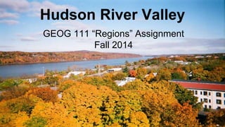
The document summarizes geographic and climatic information about the Hudson River Valley region. It discusses the valley's location, temperature and precipitation patterns, atmospheric disturbances, evapotranspiration and hydrology, rock types and crustal formation, landforms such as glacial fjords, soil types, and plant and animal life. The valley has a humid continental climate with warm summers and cold, snowy winters influenced by its proximity to large rivers and position along the coast. It contains various rock types like sandstone and experiences weathering from past glacial activity that helped form landscape features.
Flood, Flow and Flux: Climate variability and effects of the Kafue River regu...Premier Publishers
Governing common property resources for pastoralism in floodplains is a challenge. The case of the Kafue Flats in Southern Zambia in Namwala District illustrates how pastoralists have developed multiple resilience strategies to climate variability and altered flooding, flow and flux of the Kafue River between two dams. Accordingly, population in cattle have increased from 123,016 in 2010 to 123,738 in 2011, 128,898 in 2012 to 132,797 in 2013, and 135,306 in 2014 to 139,945 in 2015 and 145, 445 in 2016. This increase has reduced the area available for grazing per cow with respect to access to water and pasture. Compounded by droughts and increase in cattle numbers, the hectarage per cow has continued to decline from 3.8, 2.6 to 1.9 and 3.7, 2.4 to 1.7 in 2005 and 2017 in the Flats, lagoons and dry land respectively. This means that the Kafue Flats is prone to overgrazing in view of combined increased floodplain agriculture, successive droughts and increase in cattle numbers. Thus, due to lack of an enabling legal environment that protect pasture in common floodplains as well as pastoralists’ productive assets and livelihoods, climate variability and altered Kafue River flow has threatened the resilience and management of common property resources in Namwala. Grazing and cropping patterns have changed dramatically and flood-dependent livelihoods are threatened. Thus, this study re-conceptualizes the Kafue Flats as a dynamic ecotone ecosystem, one in which new rules for Kafue River governance can sustain pastoralism into a vital economic, ecological and energetic sector.
Most of the earth is covered by ocean waters. Oceans are very important. They affect weather, and because of uneven heating from the sun, currents of warmer water flow through colder ocean water. Winds cause waves.
Exploring What a Drought Is Essay
Essay on Drought as a Natural Disaster
California Drought Essay
Persuasive Essay On Drought
Essay Effects on Drought
Droughts in Chad Essay
Central Valley Drought
Essay On California Drought
Estuaries unique environment makes them a great place for humans and animals. Humans benefit from the beauty of estuaries and the food and resources they provide. Estuaries make great tourism attractions or harbors and ports
#36068 Topic SCI 207 Our Dependence upon the EnvironmentNumber.docxAASTHA76
#36068 Topic: SCI 207 Our Dependence upon the Environment
Number of Pages: 1 (Double Spaced)
Number of sources: 2
Writing Style: APA
Type of document: Essay
Academic Level:Undergraduate
Category: Environmental Issues
Language Style: English (U.S.)
Order Instructions: ATTACHED
Week 3 - Assignment 1
Ground and Surface Water Interactions Laboratory
[WLO: 2] [CLOs: 1, 3, 4, 5]
This lab enables you to design models of different scenarios that affect the earth’s surface water and groundwater.
The Process:
Take the required photos and complete all parts of the assignment (calculations, data tables, etc.). On the “Lab Worksheet,” answer all of the questions in the “Lab Questions” section. Finally, transfer all of your answers and visual elements from the “Lab Worksheet” into the “Lab Report.” You will submit both the “Lab Report” and the “Lab Worksheet” to Waypoint.
The Assignment:
Making sure to complete all of the following items before submission:
Before you begin this assignment, read the Groundwater and Surface Water Interactions Investigation ManualPreview the document and review The Scientific Method (Links to an external site.)Links to an external site.presentation video.
Follow the instructions in the manual to complete Activities 1, 2, and 3 using materials in your kit, augmented by additional materials that you will supply. Photograph each activity following these instructions:
When taking lab photos, you need to include in each image a strip of paper with your name and the date clearly written on it.
Complete all parts of the Week 3 Lab WorksheetPreview the document and answer all of the questions in the “Lab Questions” section.
Transfer your responses to the lab questions and data tables and your photos from the “Lab Worksheet” into the “Lab Report” by downloading the Lab Report TemplatePreview the document.
Submit your completed “Lab Report” and your “Lab Worksheet” through Waypoint.
Groundwater and Surface
Water Interactions
Investigation
Manual
ENVIRONMENTAL SCIENCE
Made ADA compliant by
NetCentric Technologies using
the CommonLook® software
Key
Personal protective
equipment
(PPE)
goggles gloves apron
follow
link to
video
photograph
results and
submit
stopwatch
required
warning corrosion flammable toxic environment health hazard
GROUNDWATER AND SURFACE WATER INTERACTIONS
Overview
Clean drinking water is vital for all human life. In this lab, students
will learn how freshwater sources interact through the natural
processes of the hydrosphere (all the water on the planet)
and what happens to drinking water supplies when our planet
becomes altered by human activities. Students will design models
of different scenarios that affect the earth’s surface water and
groundwater. The models will demonstrate overconsumption and
dro
Background
The hydrosphere encompasses all the water
on the planet. It includes freshwater and
saltwater; liquid, solid, and vapor; and water
.
10/24/13 Demand Exceeds Supply | ABQJournal Online
www.abqjournal.com/99175/upfront/demand-exceeds-supply.html 1/3
abqjournal.com http://www.abqjournal.com /99175/upfront/dem and-exceeds-supply.htm l
John Fleck / Journal Staff Writer Tue, Apr 10, 2012
Demand Exceeds Supply
Kelly Redmond, a government climatologist who lives at the interface between the
water nature provides and the humans who want to use it, came up with the best
definition of drought I’ve seen: “insufficient water to meet needs.”
The word “drought” most often conjures up the natural side of the equation – the
amount of rain and snow that falls from the sky. But Redmond, of the Western
Regional Climate Center in Reno, captures a central truth about life in an arid
landscape.
Drought is not only about supply. It also is about demand.
Redmond’s words came to mind over the past week as I watched the differing reactions to the Rio Grande runoff forecast
for April.
At San Marcial, the last Rio Grande measurement point above Elephant Butte, the forecast calls for 29 percent of the
long-term average. If it holds up, it would mean 13 of the past 15 years have had below-average runoff.
Any way you look at it, that qualifies as a drought.
The result is very little river water for farmers. “We’re crushed,” said Gary Esslinger, who manages the Elephant Butte
Irrigation District, delivering what water there is to Lower Rio Grande Valley farmers.
Wet years have a way of covering up a multitude of water management sins. Drought exposes them for all to see.
Back in the 1990s, we had all the same underlying water management problems in this state, but a string of wet years
left Elephant Butte full and allowed us to ignore our problems.
A run of 13 dry years out of 15 years since then on the Lower Rio Grande has left us with insufficient water to meet the
needs of all the water users in the Lower Rio Grande Valley.
http://www.abqjournal.com/99175/upfront/demand-exceeds-supply.html
10/24/13 Demand Exceeds Supply | ABQJournal Online
www.abqjournal.com/99175/upfront/demand-exceeds-supply.html 2/3
It’s hard to keep track of who’s suing who as a result.
The New Mexico Attorney General’s Office last year sued the federal government over the way Elephant Butte’s water is
accounted for and managed, a feud that has either directly or indirectly dragged in other water users up and down the
river, from the farmers in the Albuquerque reach of the river to Las Cruces, all choosing sides.
Meanwhile, Colorado, New Mexico and Texas can’t agree on how to account for who owns how much of the pool that
sits now in Elephant Butte. At a meeting of the Rio Grande Compact Commission in Austin last month, representatives
of the three states ended up in a standoff on the question. The water accounting sheets developed by the three states
explaining their competing views of hydrologic reality run to 23 pages total.
Then in the past few weeks, the early release of water from Elepha ...
Ocean notes: a comprehensive study on different ocean zones including intert...Robin Seamon
a comprehensive study on different ocean zones including intertidal, euphotic, disphotic, and aphotic zones, mentioning global warming & climate change, currents, energy flows, with video links
This is a presentation by Dada Robert in a Your Skill Boost masterclass organised by the Excellence Foundation for South Sudan (EFSS) on Saturday, the 25th and Sunday, the 26th of May 2024.
He discussed the concept of quality improvement, emphasizing its applicability to various aspects of life, including personal, project, and program improvements. He defined quality as doing the right thing at the right time in the right way to achieve the best possible results and discussed the concept of the "gap" between what we know and what we do, and how this gap represents the areas we need to improve. He explained the scientific approach to quality improvement, which involves systematic performance analysis, testing and learning, and implementing change ideas. He also highlighted the importance of client focus and a team approach to quality improvement.
Palestine last event orientationfvgnh .pptxRaedMohamed3
An EFL lesson about the current events in Palestine. It is intended to be for intermediate students who wish to increase their listening skills through a short lesson in power point.
Instructions for Submissions thorugh G- Classroom.pptxJheel Barad
This presentation provides a briefing on how to upload submissions and documents in Google Classroom. It was prepared as part of an orientation for new Sainik School in-service teacher trainees. As a training officer, my goal is to ensure that you are comfortable and proficient with this essential tool for managing assignments and fostering student engagement.
The French Revolution, which began in 1789, was a period of radical social and political upheaval in France. It marked the decline of absolute monarchies, the rise of secular and democratic republics, and the eventual rise of Napoleon Bonaparte. This revolutionary period is crucial in understanding the transition from feudalism to modernity in Europe.
For more information, visit-www.vavaclasses.com
Ethnobotany and Ethnopharmacology:
Ethnobotany in herbal drug evaluation,
Impact of Ethnobotany in traditional medicine,
New development in herbals,
Bio-prospecting tools for drug discovery,
Role of Ethnopharmacology in drug evaluation,
Reverse Pharmacology.
2024.06.01 Introducing a competency framework for languag learning materials ...Sandy Millin
http://sandymillin.wordpress.com/iateflwebinar2024
Published classroom materials form the basis of syllabuses, drive teacher professional development, and have a potentially huge influence on learners, teachers and education systems. All teachers also create their own materials, whether a few sentences on a blackboard, a highly-structured fully-realised online course, or anything in between. Despite this, the knowledge and skills needed to create effective language learning materials are rarely part of teacher training, and are mostly learnt by trial and error.
Knowledge and skills frameworks, generally called competency frameworks, for ELT teachers, trainers and managers have existed for a few years now. However, until I created one for my MA dissertation, there wasn’t one drawing together what we need to know and do to be able to effectively produce language learning materials.
This webinar will introduce you to my framework, highlighting the key competencies I identified from my research. It will also show how anybody involved in language teaching (any language, not just English!), teacher training, managing schools or developing language learning materials can benefit from using the framework.
5. Task 2: Temperature and Precipitation
The Hudson River Valley generally borders both the Hudson and Mohawk
rivers. Due to the influence of high insolation levels, correlating high
temperatures tend to be between the months of April and September.
Because of its latitude is farther away from the equator the insolation isn’t
as direct and covers larger areas of land, so an obliquity increase would
make sense. During the winter months Hudson Valley gets 8-9 hours of
sunlight a day, 11-12 in the fall and spring months, and 13-15 during the
summer. The presence of the river contributes to precipitation levels, but
current climate change factors have made New York as a state much
warmer and more dry on average. Precipitation levels are higher in the
summer months.
Source: http://pveducation.org/pvcdrom/properties-of-sunlight/calculation-of-solar-insolation
9. Task 3: Atmospheric Disturbances
The Hudson River Valley frequently suffers from high winds,
thunderstorms, and occasional tornadoes. The low pressure
systems throughout the east coast cause the cold fronts and
strong winds within the valley. When high pressures create strong
trade winds in lower atmospheres it creates more instability, which
can cause discrete thunderstorms that top off into tornadoes in the
valley. Air masses in this region also have a very large effect on
atmospheric disturbances. The fact that the estuary acts as an
inland wetland helps prevent atmospheric disturbances such as
flooding in this region.
Source: cbsalbany.com wind patterns and tornado
11. Task 4: Evapotranspiration and Precipitation
Source: http://ny.water.usgs.gov/pubs/of/of96395/OF96-395.plate2.pdf
12. Task 4: Mean Annual Precipitation
Source: http://www.weather.gov/images/btv/climo/NY_annual_precip.png
13. Task 4: Mean Annual Evaporation
Source: https://www.extension.purdue.edu/extmedia/NCh/images/NCH-40.fig8.gif
14. Task 4: Net Moisture Regimes
Source: http://atlas.gwsp.org/atlas/img/map/viwb1_0_wl.png
15. Task 5: Climate Description
Hudson Valley is a microthermal Dfb climate because of its warmer
summers that are above 71.6 degrees while being humid
continental but with less precipitation in the winters. Precipitation
levels can go down to less than an inch and max out around 6
inches, with an average of 2.6 inches. The average temperature is
about 55 degrees, but in the winter months can get as cold as 18
degrees. Polar easterlies winds are what contribute to the colder
weather.
Source: http://www.cee.cornell.edu/academics/graduate/upload/FinalWindReportSpring2010.pdf
16. Task 6: Rock Types and Processes
Hudson River Valley is a physiographic section of the Ridge
and Valley province, which is part of the Appalachain region.
The Valley is made up of many different rock types ranging
the south and eastern edges of New York state, cutting
through sandstones, redbeds, and gneisses dating back to
the Triassic and Precambrian eras. Over the centuries and
through the ice ages the rivers have formed a fjord cut
caused by glacial erosion.
Source: http://3dparks.wr.usgs.gov/nyc/valleyandridge/hudsonvalley.htm
18. Task 6: New York State Geologic Map
Source: http://3.bp.blogspot.com/-JY0j7bwFtww/T7Yse-B4ijI/AAAAAAAACRA/HgWAGtfSEaM/s1600/nys.gif
19. Task 7: Crustal Formation
The valley is basin within the Canadian
shield that was subject to jointing. The basin
was probably caused by lithospheric
stretching.
Source: http://einstein.byu.edu/~masong/htmstuff/textbookpdf/C28.pdf
http://www1.gly.bris.ac.uk/~ibastow/DOCS/Pawlak11.pdf
20. Task 8: Weathering and mass wasting
I believe that the hudson valley underwent
the process of physical weathering, abrasion
in particular because of the large fjords
within the valley.
21. Task 9: Streams, Rivers, and Associated Landforms
The Hudson river is a graded river and the most
obvious landform in the Hudson River Valley. The
Hudson river doubles as both a river and a tidal estuary,
but is currently suffering major pollution issues draining
into the Atlantic discharge basin. The spring run-off from
the estuary contributes to the levels of high precipitation
in some months and prevents droughts in others.
Sources: http://www.centralia.edu/academics/earthscience/cheh_geo/lectures/streams.pdf
http://www.dec.ny.gov/lands/4923.html
22. Task 10c: Glacial and periglacial landforms
A glacial landform in the Hudson River Valley is a
fjord, formed by flood in which sea extends and fills
lower reaches of steep valleys. It appeared in this
region because the glacial trough intersected with
the ocean, eroding the landscape below sea level.
Source: Elemental Geosystems book
23. Task 10c: Glacial and periglacial landforms
Source: http://hikewestchester.myvolition.com/hudson-highlands-state-park-breakneck-ridge-loop/
24. Task 11: Soil Regimes
The Hudson River Valley is a udic soil regime because it can be
considered a subhumid climate. The specific soil type is alfisols,
which has a moderate to high amount of base saturation and is
moderately weathered with an illuviated clay accumulation. It is
common among high latitudes. If it is supplemented with adequate
precipitation and temperature it can make agriculture extremely
active. In this particular area it would be more likely to produce
grains, hay, and dairy products.
Sources: http://passel.unl.edu/pages/informationmodule.php?idinformationmodule=1130447033&topicorder=11&maxto=13
26. Task 12: Plant and animal regimes
The Hudson River Valley is known as a biological crossroads for both plants and
animals. Because of its location it brings together animals of all habitats and houses
over two thousand species. Specifically, the Valley is ranked in the top four
drainages
in the world for turtle species richness. An
example is the eastern box turtle, pictured to
the left, which is for the most part New York
state specific as it needs several different
types of habitats to live.
Sources: http://blog.pennlive.com/midstate_impact/2009/05/large_boxturtle.jpg ,
http://www.dec.ny.gov/docs/remediation_hudson_pdf/hrebch3.pdf
Although the valley isn’t in a
coastal region, the fact that it doubles as an
estuary creates housing for many different
coastal species. Examples of these are the
blue crab, hudson river water nymph, least
bittern, and the black-crowned night heron.
27. Task 12: Plant and animal regimes
Plant harvesting is somewhat of a problem in the valley. As many plant
species die out, it is thought that botanical industries and other commercial
companies are overharvesting plants in the area that they can use to their
advantage (building canoes, tanning of leather, etc.). With that being said,
some of the plants that are currently present are the gayfeather, the native
“pink lady’s sleeper”, hummingbird mint, etc. These are able to survive
because of the estuary and the inland wetlands of the region as well as the
good amount of sunlight that stays within the region for most of the year.
Sources: http://brianaltonenmph.com/6-medical-anthropology/hudson-valley-plant-heritage/,
http://www.hvmag.com/Hudson-Valley-Magazine/June-2010/Habitat-Gardening/
28. Task 12: Plant and animal regimes
Source: http://1.bp.blogspot.com/-F94QjaUMpO8/TzgzWpZFlyI/AAAAAAAABgU/3WO5ufzd_Ss/s1600/USDA+hardiness+zone+map.jpg
http://planthardiness.ars.usda.gov/PHZMWeb/Images/150dpi/NE_reg_150.jpg