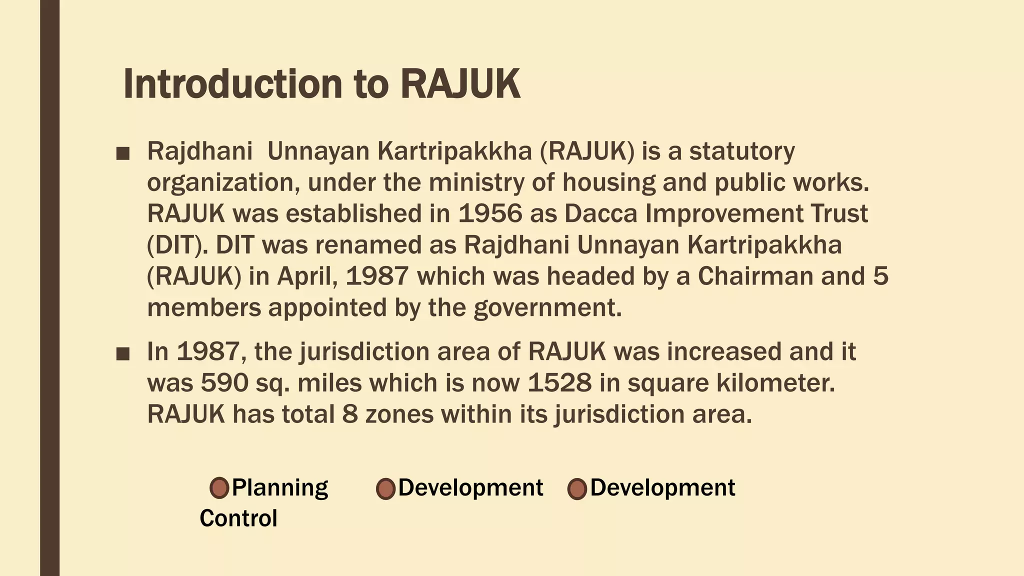
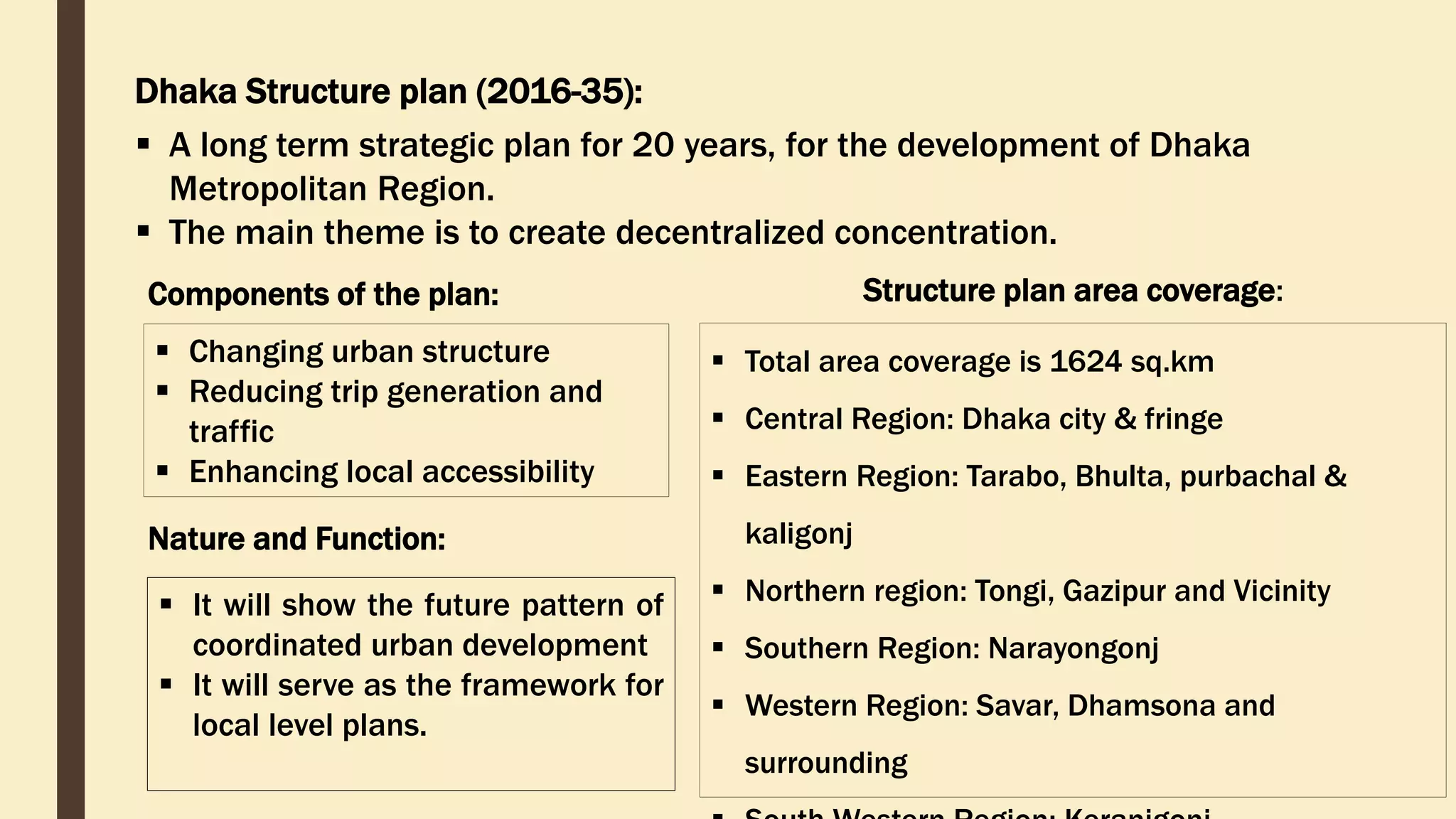
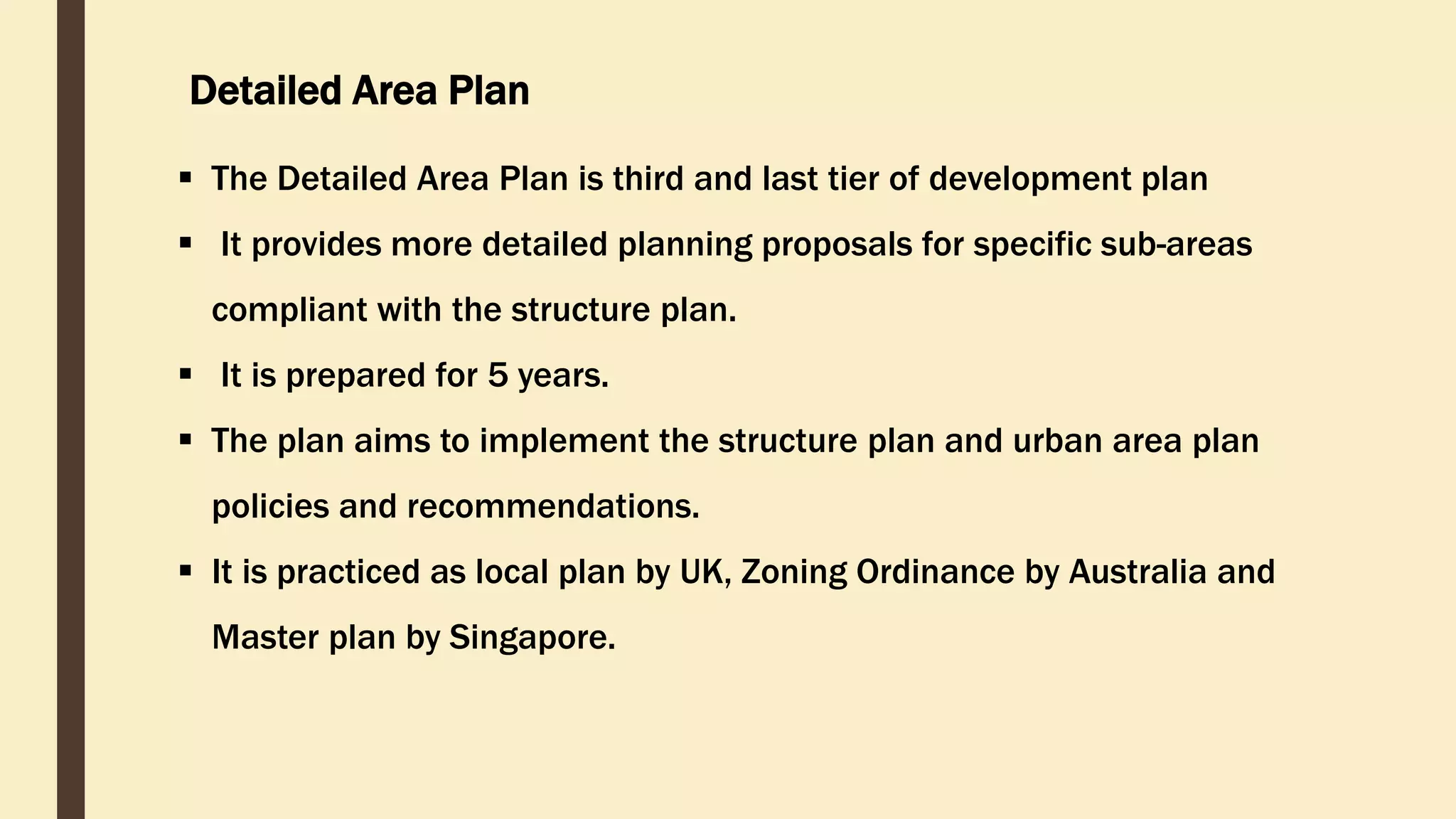
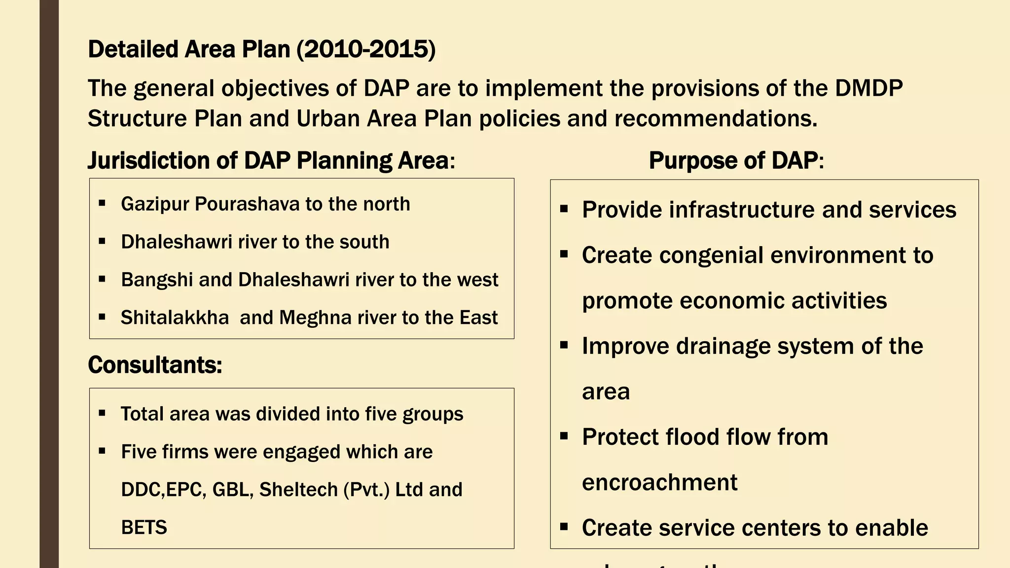
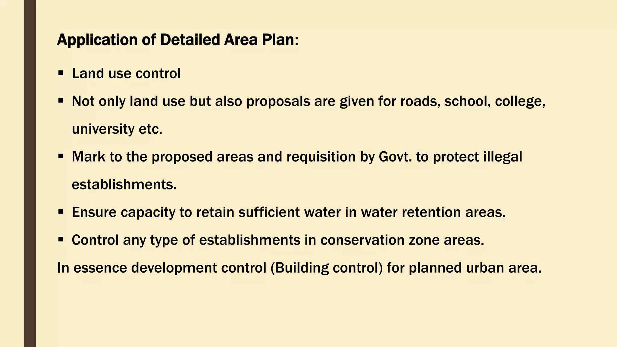
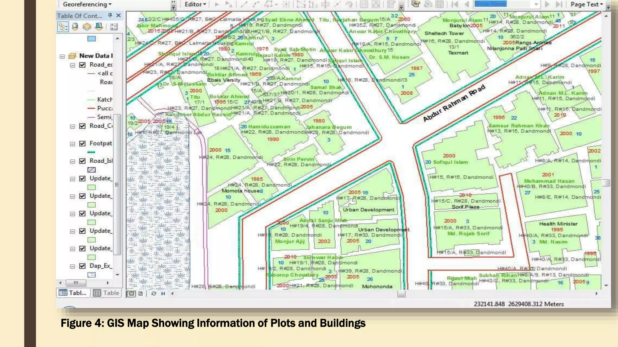
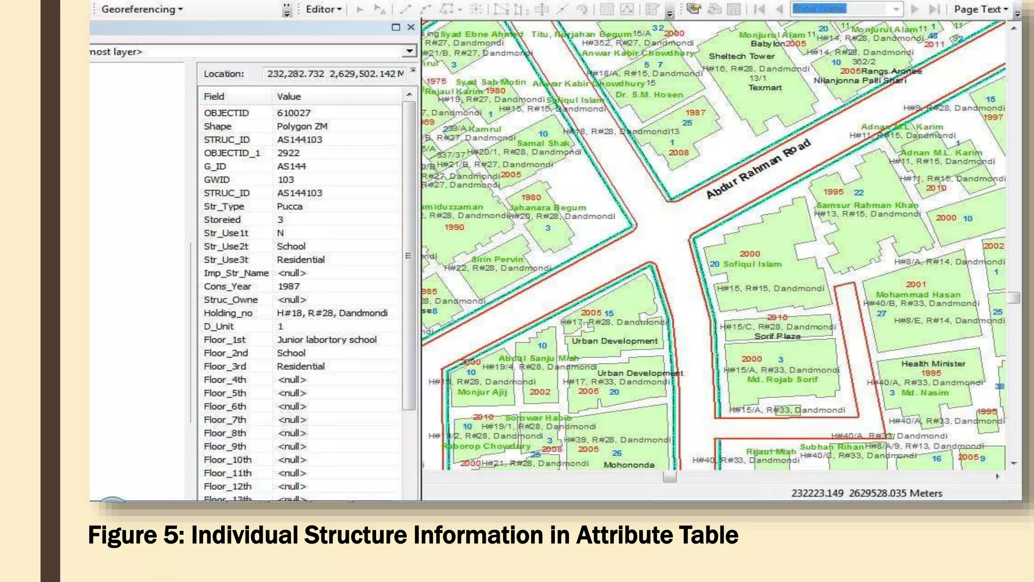
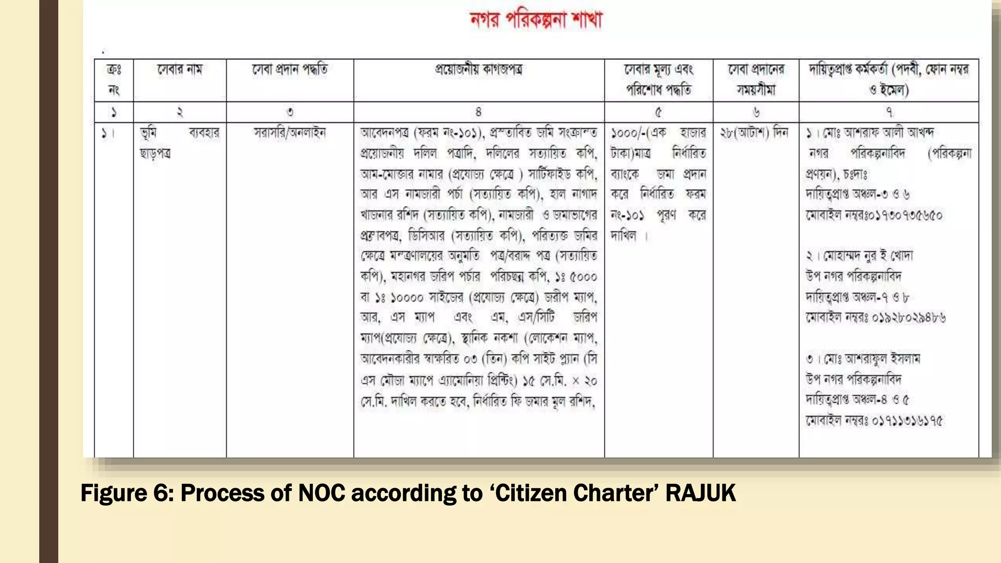
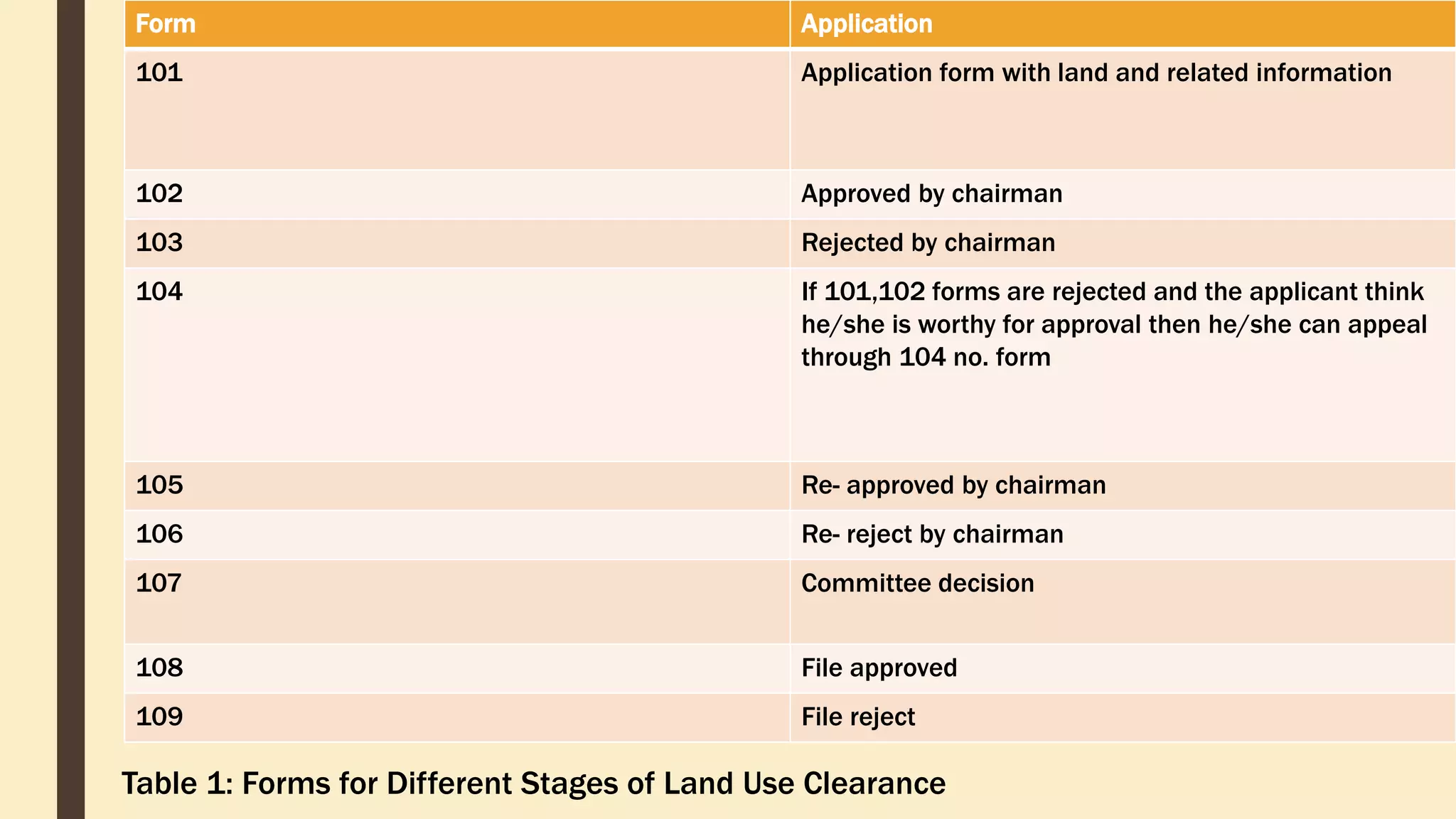
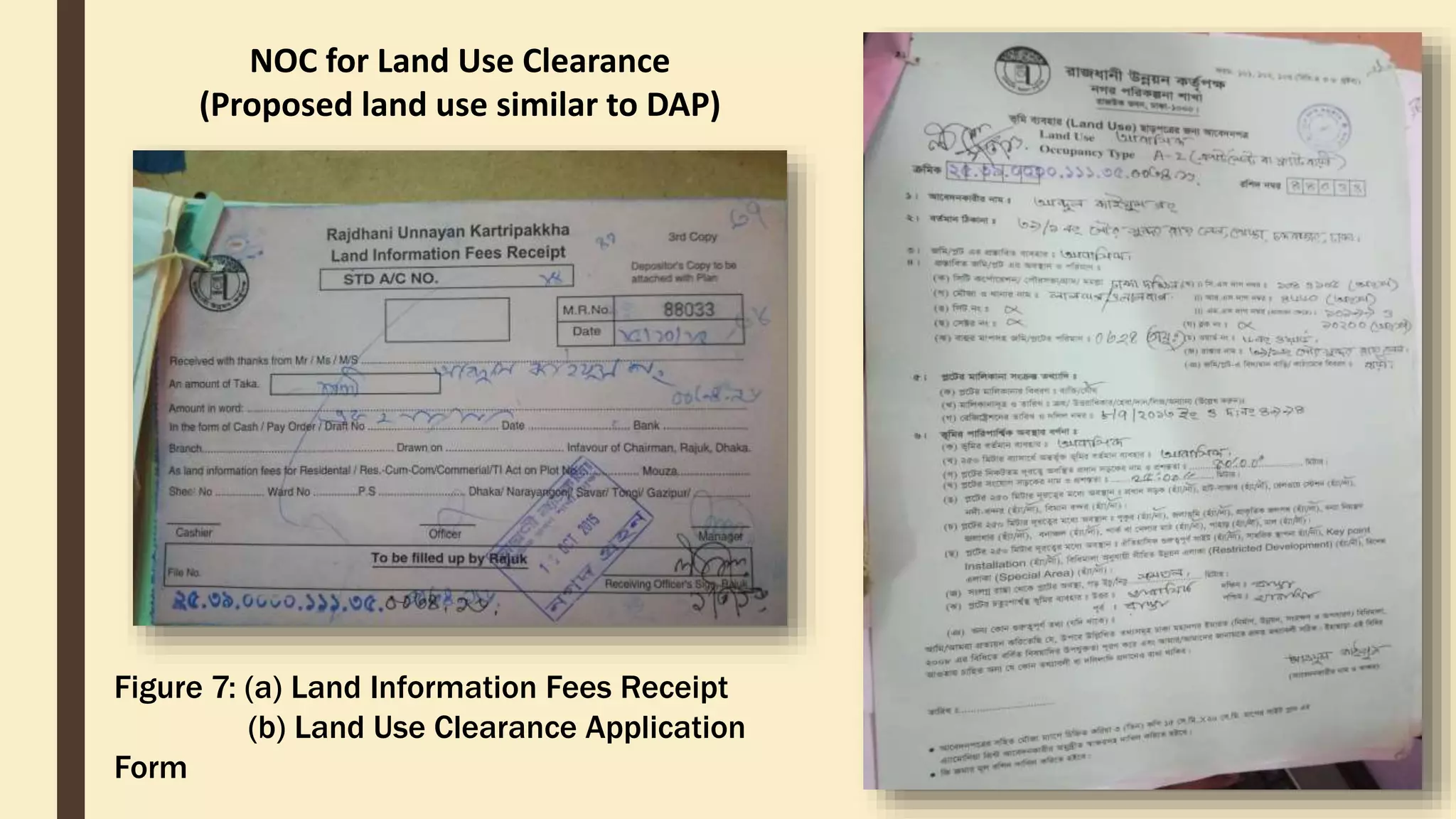
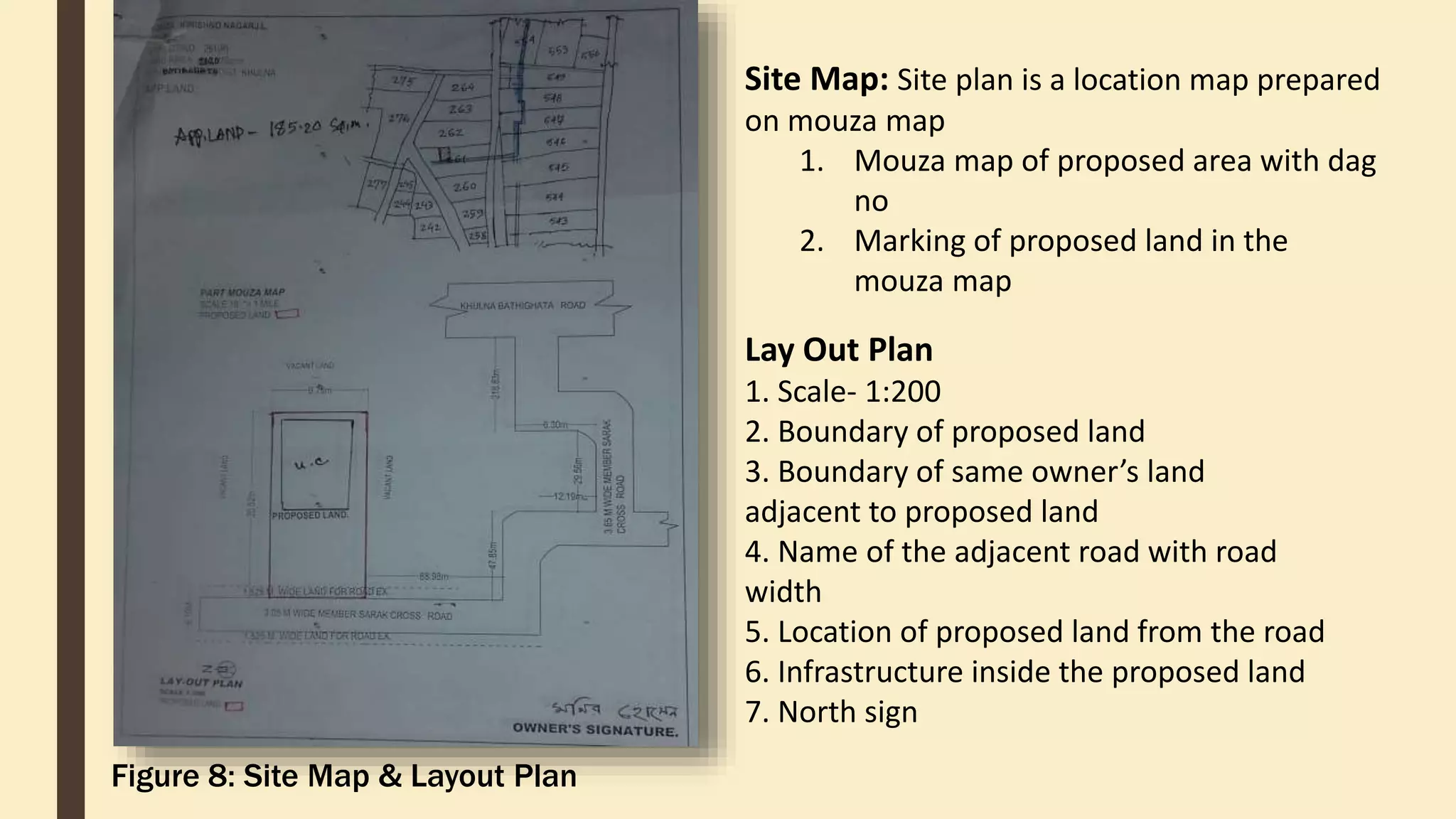
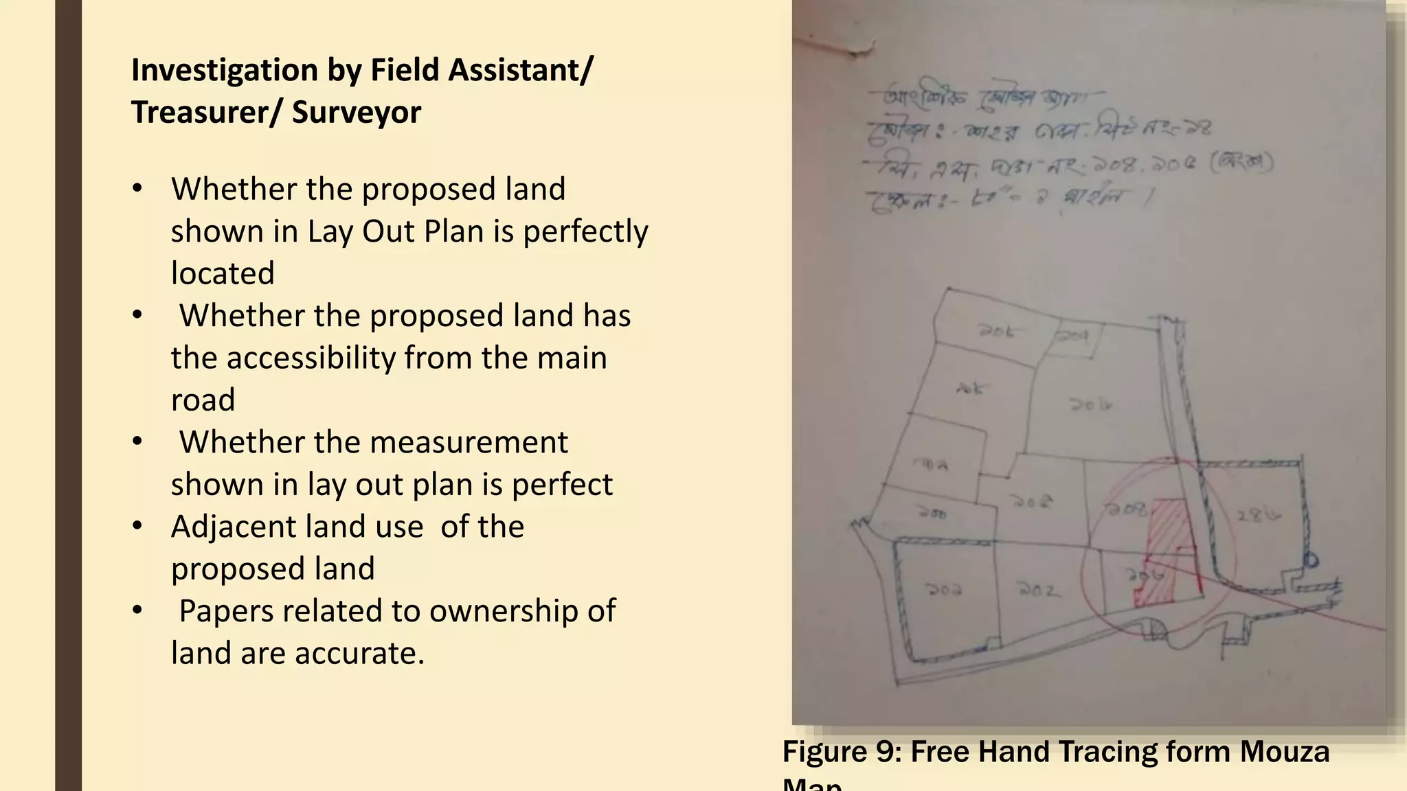
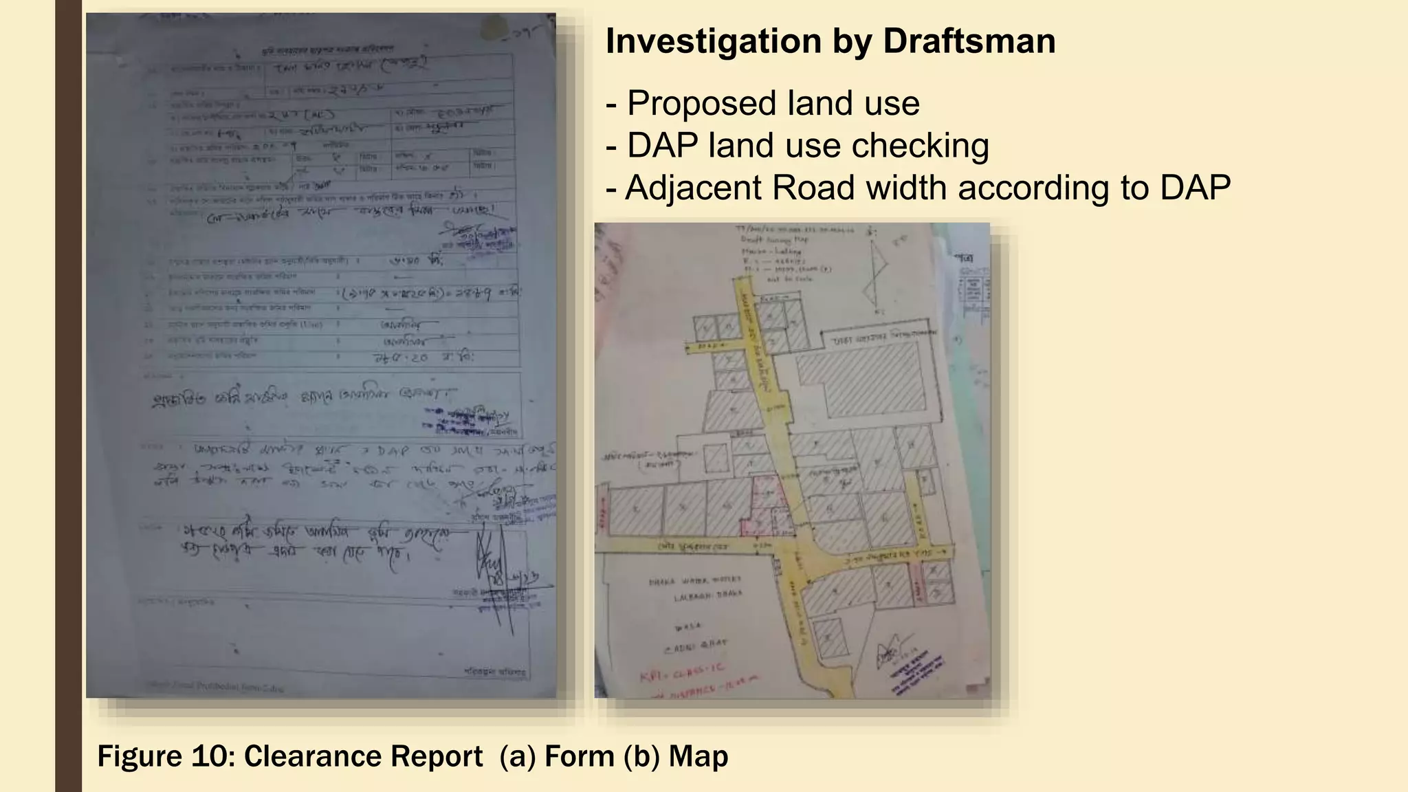
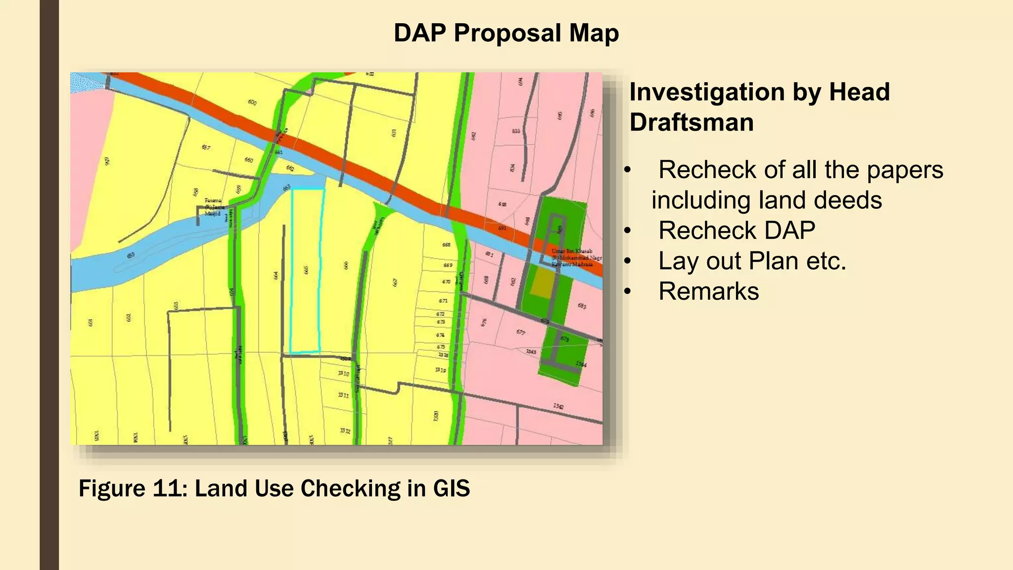
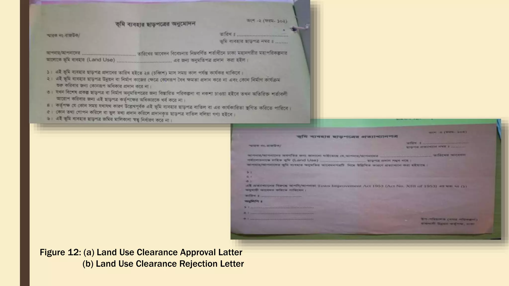
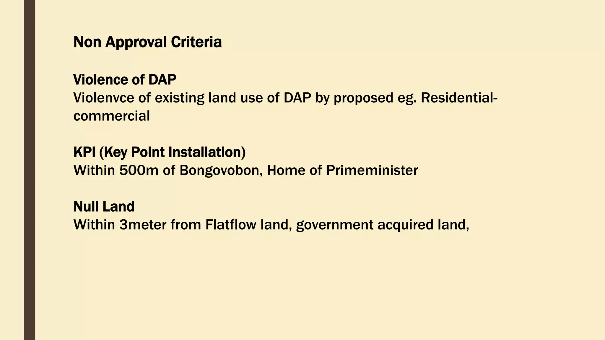
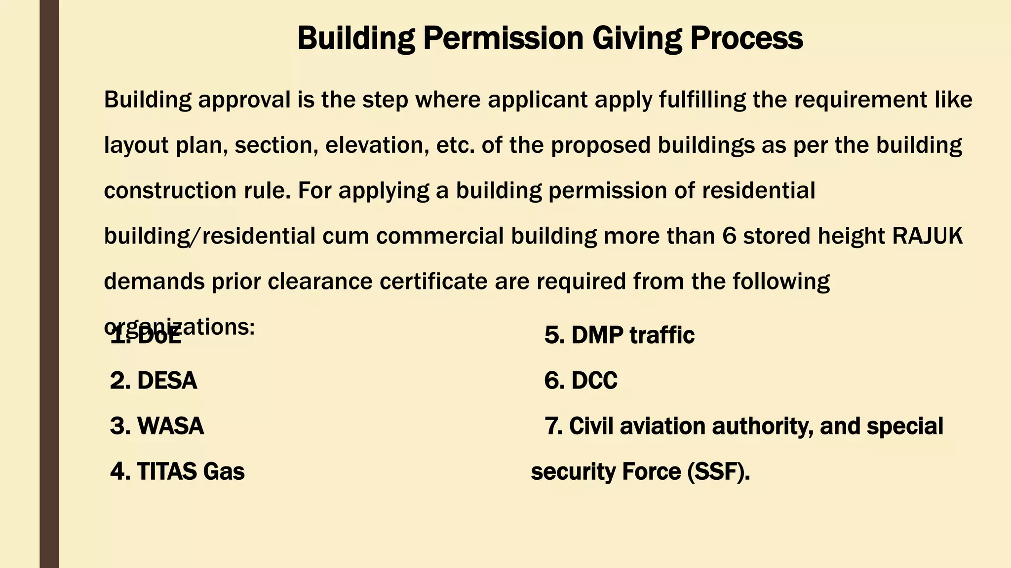
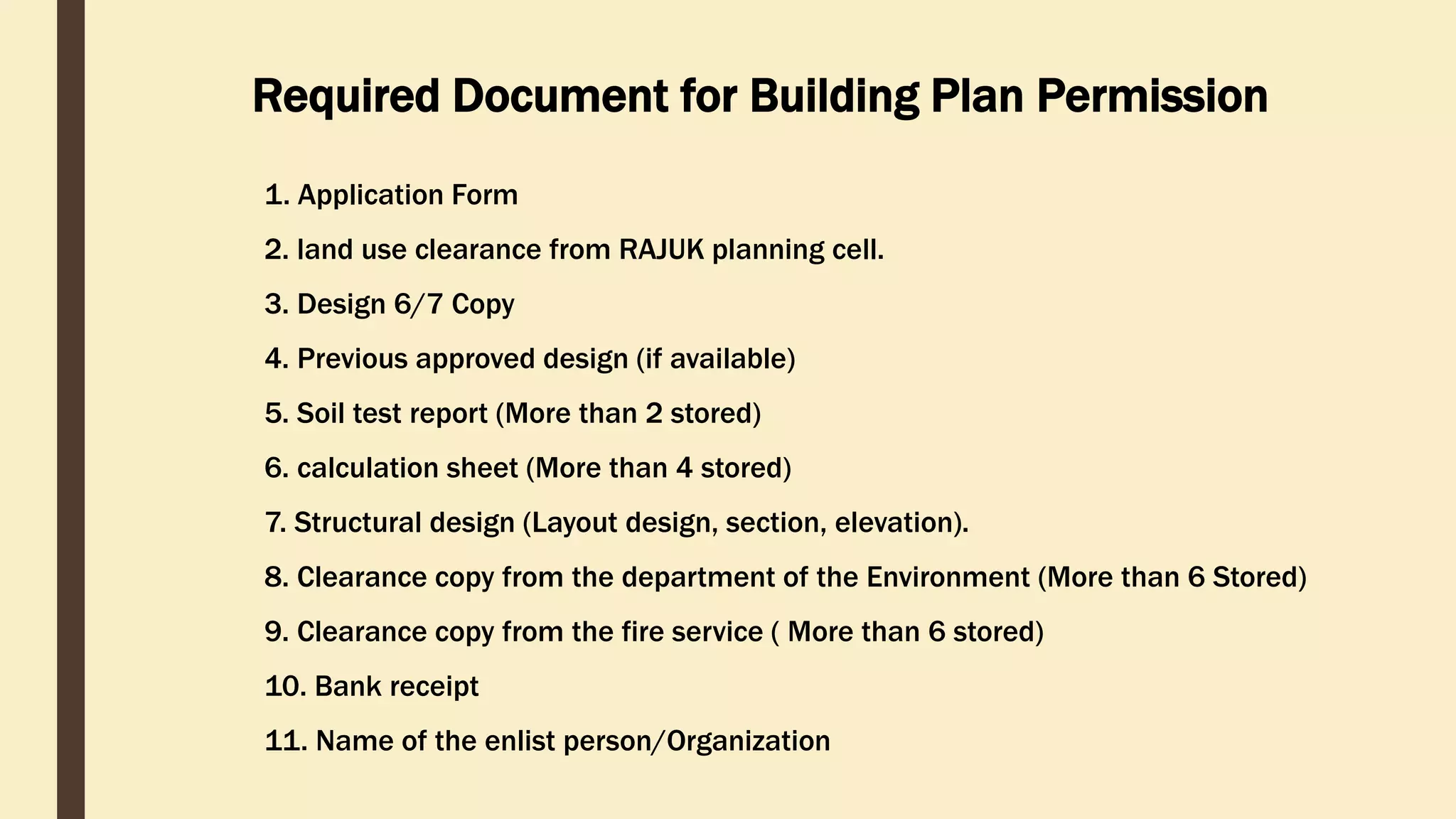
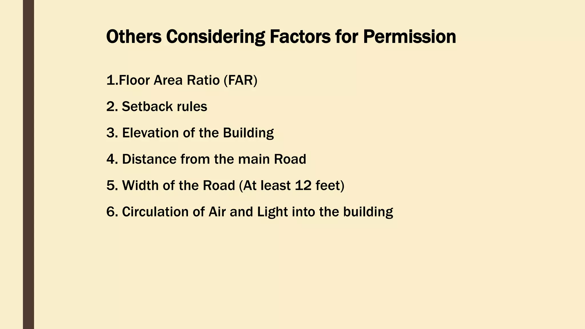
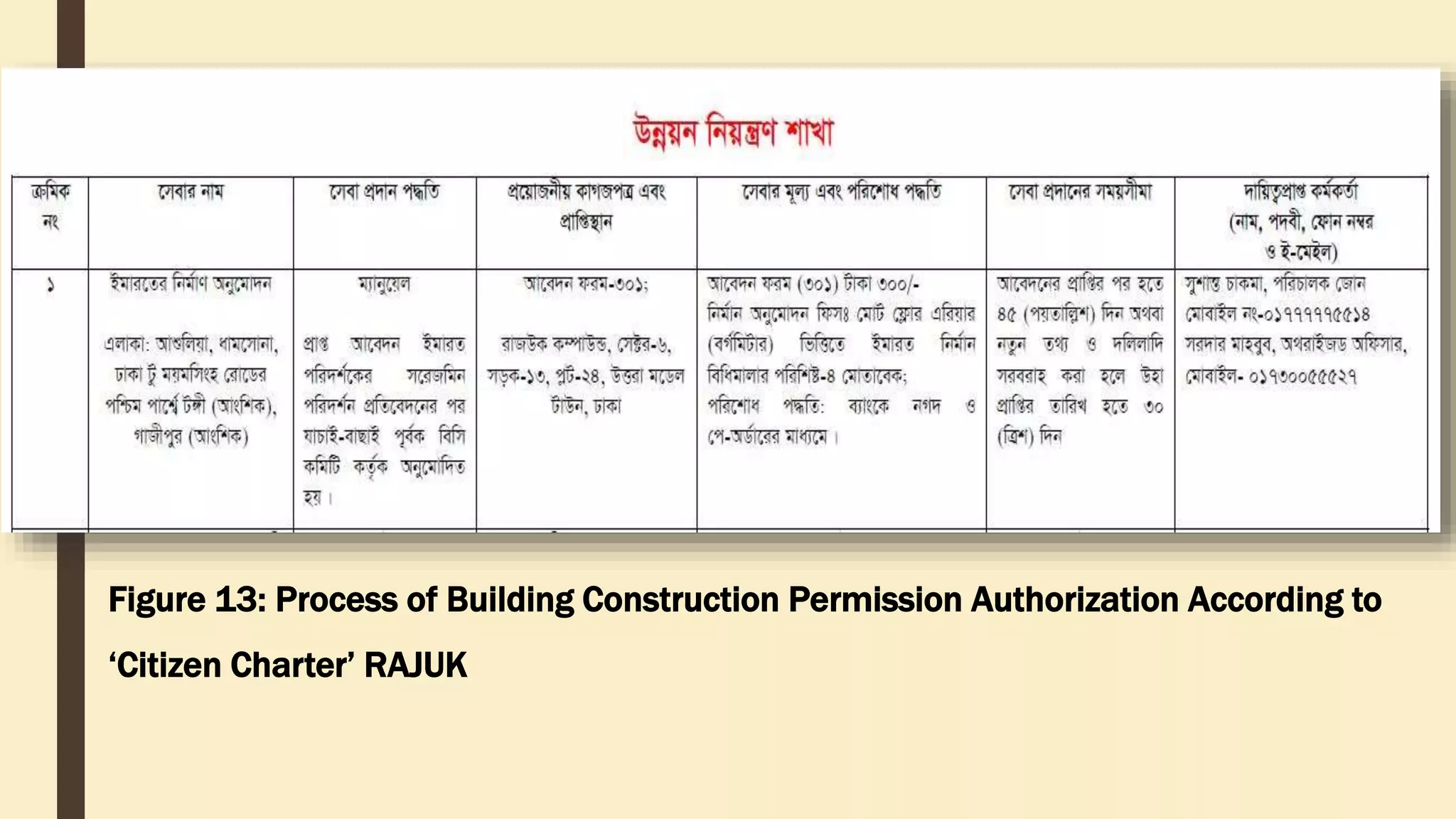
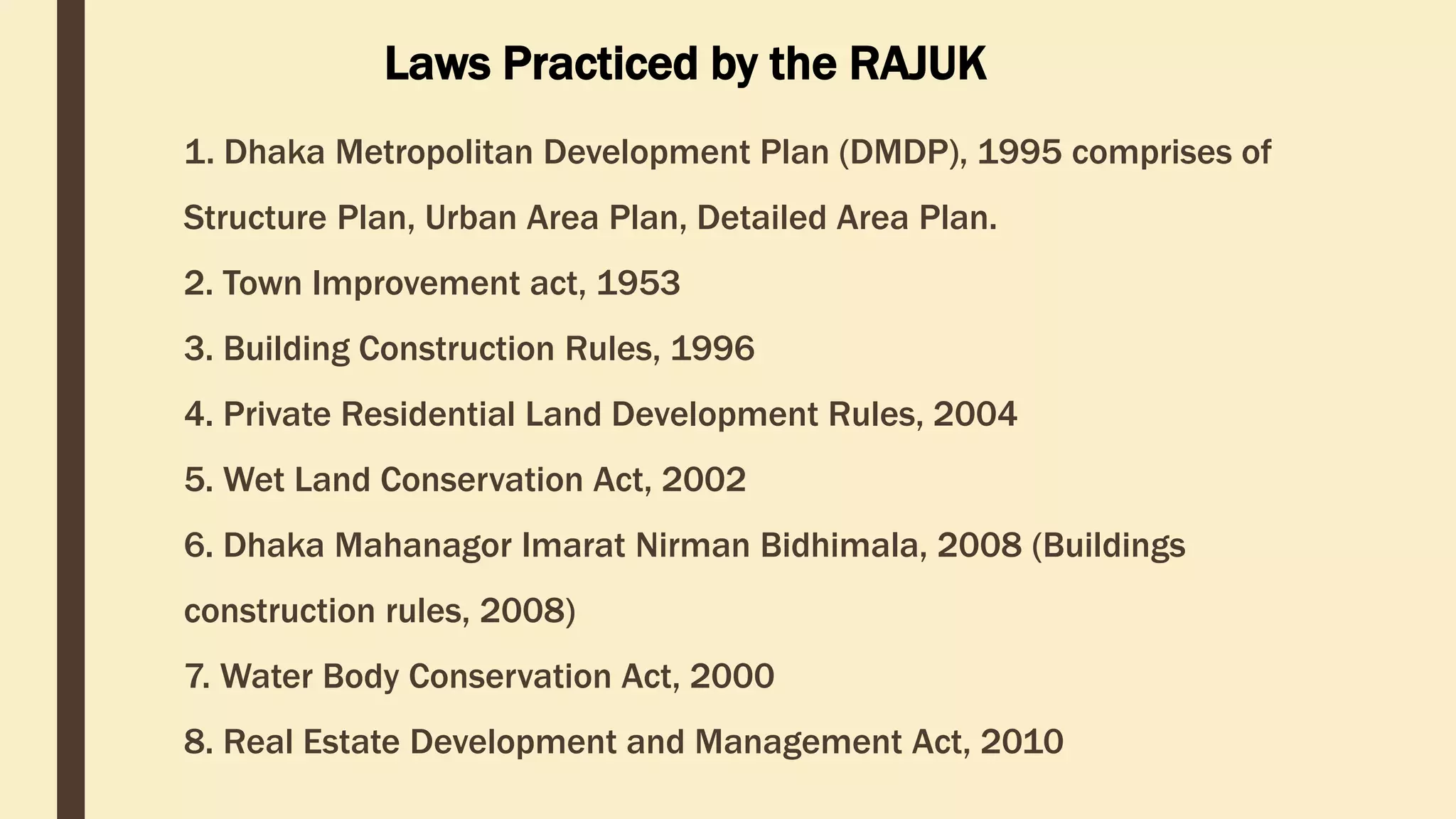
SlideShare a Scribd company logo
RAJUK FROM CITYTO HOME
AN OVERVIEW ON DEVELOPMENT PLAN, LAND USE &
BUILDING PERMISSION
Prepared By – 120417, 23, 36, 37, 40
CONTENTS
 Introduction to RAJUK
 From City : Development Plan for Dhaka
 To Home: Land use Clearance and Building Permission
Authorization Process
 Learning Outcomes
 Pictures of Intern Days
Introduction to RAJUK
■ Rajdhani Unnayan Kartripakkha (RAJUK) is a statutory
organization, under the ministry of housing and public works.
RAJUK was established in 1956 as Dacca Improvement Trust
(DIT). DIT was renamed as Rajdhani Unnayan Kartripakkha
(RAJUK) in April, 1987 which was headed by a Chairman and 5
members appointed by the government.
■ In 1987, the jurisdiction area of RAJUK was increased and it
was 590 sq. miles which is now 1528 in square kilometer.
RAJUK has total 8 zones within its jurisdiction area.
Planning Development Development
Control
Vision & Mission of RAJUK
Vision
To be an apex planning authority to build a healthy and
livable capital city Dhaka.
Mission
Planning, Development and Development control and
manage the growth of Dhaka city.
ORGANOGRAM OF RAJUK
The existing structure of the organization stands with the old version of
organogram having 728 officials in which 140 officials under Planning
Section are shown the working strength of the Authority. The new
organogram 2013 has been approved by the Ministry of Public
Administration.
Member
(Estates)
Chairman
Member
(Admin &
Finance)
Member
(Planning)
Member
(Development)
Member (Dev.
Control)
SeniorSystem
Analyst
ChiefEngineer
ChiefTown
Planner
Director
(Estates)
Director
(Finance)
Director
(Admin)
Director(Dev.
Control)-I
Director(Dev.
Control)-II
ChiefArchitect
Figure 1: Organogram of RAJUK
• Primary layout design of Uttara Apartment Project
• Design of Apartment Project at Hatirjhil
• Revised layout plan of Jhilmil Residential Project
• Preparing of layout plans for individual plot allot tee of Purbachal
Project
• Site office design of Uttara, Purbachal Project etc.
• Kuril Flyover
• Nikunja (south)
• Jhilmil
• Uttara 3rd Phase
• Purbachal New Town (Running)
SOME PROJECTS DONE BY RAJUK
FROM CITY:
DEVELOPMENT PLAN
FOR DHAKA
Structure Plan
 A broad guidelines, policy level plan.
 A long term strategy for the development of 20 years by policy guidelines.
 The word was first used by British.
 After 90s the word was replaced by strategic plan. But still now structure plan is
practiced in our country.
 It is practiced as concept plan by Singapore, development plan by Australia and
America.
Master Plan
 It was practiced before recent DMDP.
 The plan was used to prepare for 10 years.
 But it’s a rigid plan.
 It does not accept any kind of change such as economy, people’s mentality or other
change
 Then developed countries replaced master plan by structure plan and detailed area
plan
Dhaka Structure plan (2016-35):
Components of the plan:
 Changing urban structure
 Reducing trip generation and
traffic
 Enhancing local accessibility
Structure plan area coverage:
 Total area coverage is 1624 sq.km
 Central Region: Dhaka city & fringe
 Eastern Region: Tarabo, Bhulta, purbachal &
kaligonj
 Northern region: Tongi, Gazipur and Vicinity
 Southern Region: Narayongonj
 Western Region: Savar, Dhamsona and
surrounding
Nature and Function:
 It will show the future pattern of
coordinated urban development
 It will serve as the framework for
local level plans.
 A long term strategic plan for 20 years, for the development of Dhaka
Metropolitan Region.
 The main theme is to create decentralized concentration.
Detailed Area Plan
 The Detailed Area Plan is third and last tier of development plan
 It provides more detailed planning proposals for specific sub-areas
compliant with the structure plan.
 It is prepared for 5 years.
 The plan aims to implement the structure plan and urban area plan
policies and recommendations.
 It is practiced as local plan by UK, Zoning Ordinance by Australia and
Master plan by Singapore.
Detailed Area Plan (2010-2015)
The general objectives of DAP are to implement the provisions of the DMDP
Structure Plan and Urban Area Plan policies and recommendations.
 Gazipur Pourashava to the north
 Dhaleshawri river to the south
 Bangshi and Dhaleshawri river to the west
 Shitalakkha and Meghna river to the East
Jurisdiction of DAP Planning Area: Purpose of DAP:
 Provide infrastructure and services
 Create congenial environment to
promote economic activities
 Improve drainage system of the
area
 Protect flood flow from
encroachment
 Create service centers to enable
Consultants:
 Total area was divided into five groups
 Five firms were engaged which are
DDC,EPC, GBL, Sheltech (Pvt.) Ltd and
BETS
Application of Detailed Area Plan:
 Land use control
 Not only land use but also proposals are given for roads, school, college,
university etc.
 Mark to the proposed areas and requisition by Govt. to protect illegal
establishments.
 Ensure capacity to retain sufficient water in water retention areas.
 Control any type of establishments in conservation zone areas.
In essence development control (Building control) for planned urban area.
Application of GIS in RAJUK’s Planning
Not more than a database and attribute table
However, it’s going to be the largest in BD
GIS in Revised DAP
GIS Works
■ 3D satellite image, purchased
form Geo-eye; Geo-referencing,
Digitize.
■ Validation and update of
physical feature. (CS, RS,
MS/BS)
■ Preparing Grids having grid id
and individual structure id
■ Joining information of individual
feature in GIS attribute table.
Survey Info. for GIS Input
 Structure information – Log Book [Also
info. About surveyor, Survey time for
recheck
 Besides, Roads information having Type,
Name, Width, Number, ROW
 And ‘Other Poly’ representing Graveyard,
Eidgah, Playground, Agricultural Land
 Point features like Electric and Telephone
Pole, Dustbin and line feature like
Drainage, High Voltage Electric Line is alos
digitized
GIS in Revised DAP
■ Adding Layers form WASA, Roads and Highways, GSB, BIWTA and of
KPI
■ Final Land Use Map
■ Based on Knowledge Land Use Proposal
Future Analysis Plans
■ Suitable site selection for DNCC ‘Sanitary Landfill Site’
■ Risk Sensitive Land Use Planning.
Figure 2: Log Book Used During Revised DAP Survey
Figure 3: Log Book Information Taken During Revised DAP Survey
Figure 4: GIS Map Showing Information of Plots and Buildings
Figure 5: Individual Structure Information in Attribute Table
TO HOME: LAND USE
CLEARANCE AND BUILDING
PERMISSION AUTHORIZATION
PROCESS
RAJUK is the legitimate public authority for giving permission to building
construction in. This agency is entrusted with the job of preparing plan
for Dhaka city, ensuring development as per the prepared plan and
controlling the future development. Before any sort of development a
land owner need to take the ‘land use clearance’ from RAJUK Processing
of planning permission involves in two stages:
1.Land use clearance
2. Building permission
Planning Permission
Land clearance certificate is similar to No Objection
Certificate (NOC) from the plan approval authority. It’s a
tool for development control
Required Document for Land use Clearance
o Application form
o Certifier deed
document
o Bank receipt
o DCR (duplicate carbon
receipt)
o City survey porcha
o Location Map (Mouza)
o Up- to date land tax
receipt
o RS, MS Mouza map
o CS/RS/City survey
mutation porcha
o Mutation and tax
proposal
NOC
Figure 6: Process of NOC according to ‘Citizen Charter’ RAJUK
Form Application
101 Application form with land and related information
102 Approved by chairman
103 Rejected by chairman
104 If 101,102 forms are rejected and the applicant think
he/she is worthy for approval then he/she can appeal
through 104 no. form
105 Re- approved by chairman
106 Re- reject by chairman
107 Committee decision
108 File approved
109 File reject
Table 1: Forms for Different Stages of Land Use Clearance
PROCESS OF GIVING
NOC
NOC for Land Use Clearance
(Proposed land use similar to DAP)
Figure 7: (a) Land Information Fees Receipt
(b) Land Use Clearance Application
Form
Site Map: Site plan is a location map prepared
on mouza map
1. Mouza map of proposed area with dag
no
2. Marking of proposed land in the
mouza map
Lay Out Plan
1. Scale- 1:200
2. Boundary of proposed land
3. Boundary of same owner’s land
adjacent to proposed land
4. Name of the adjacent road with road
width
5. Location of proposed land from the road
6. Infrastructure inside the proposed land
7. North sign
Figure 8: Site Map & Layout Plan
Investigation by Field Assistant/
Treasurer/ Surveyor
• Whether the proposed land
shown in Lay Out Plan is perfectly
located
• Whether the proposed land has
the accessibility from the main
road
• Whether the measurement
shown in lay out plan is perfect
• Adjacent land use of the
proposed land
• Papers related to ownership of
land are accurate.
Figure 9: Free Hand Tracing form Mouza
- Proposed land use
- DAP land use checking
- Adjacent Road width according to DAP
Investigation by Draftsman
Figure 10: Clearance Report (a) Form (b) Map
DAP Proposal Map
Investigation by Head
Draftsman
• Recheck of all the papers
including land deeds
• Recheck DAP
• Lay out Plan etc.
• Remarks
Figure 11: Land Use Checking in GIS
Figure 12: (a) Land Use Clearance Approval Latter
(b) Land Use Clearance Rejection Letter
Non Approval Criteria
Violence of DAP
Violenvce of existing land use of DAP by proposed eg. Residential-
commercial
KPI (Key Point Installation)
Within 500m of Bongovobon, Home of Primeminister
Null Land
Within 3meter from Flatflow land, government acquired land,
Building approval is the step where applicant apply fulfilling the requirement like
layout plan, section, elevation, etc. of the proposed buildings as per the building
construction rule. For applying a building permission of residential
building/residential cum commercial building more than 6 stored height RAJUK
demands prior clearance certificate are required from the following
organizations:
Building Permission Giving Process
1. DoE
2. DESA
3. WASA
4. TITAS Gas
5. DMP traffic
6. DCC
7. Civil aviation authority, and special
security Force (SSF).
Required Document for Building Plan Permission
1. Application Form
2. land use clearance from RAJUK planning cell.
3. Design 6/7 Copy
4. Previous approved design (if available)
5. Soil test report (More than 2 stored)
6. calculation sheet (More than 4 stored)
7. Structural design (Layout design, section, elevation).
8. Clearance copy from the department of the Environment (More than 6 Stored)
9. Clearance copy from the fire service ( More than 6 stored)
10. Bank receipt
11. Name of the enlist person/Organization
Others Considering Factors for Permission
1.Floor Area Ratio (FAR)
2. Setback rules
3. Elevation of the Building
4. Distance from the main Road
5. Width of the Road (At least 12 feet)
6. Circulation of Air and Light into the building
Figure 13: Process of Building Construction Permission Authorization According to
‘Citizen Charter’ RAJUK
1. Dhaka Metropolitan Development Plan (DMDP), 1995 comprises of
Structure Plan, Urban Area Plan, Detailed Area Plan.
2. Town Improvement act, 1953
3. Building Construction Rules, 1996
4. Private Residential Land Development Rules, 2004
5. Wet Land Conservation Act, 2002
6. Dhaka Mahanagor Imarat Nirman Bidhimala, 2008 (Buildings
construction rules, 2008)
7. Water Body Conservation Act, 2000
8. Real Estate Development and Management Act, 2010
Laws Practiced by the RAJUK
LEARNING
OUTCOMES
Learning with Fun
■ One to One interaction with RAJUK’s Town Planner, Deputy Town
Planners and Assistant Town Planners with Different Topics
■ Interaction with the Project Manager of Revised DAP
■ Introduction to Office Environment
■ DAP’s GIS Database Preparation Process
■ Participation in a Seminar ‘Gender Responsive Town Planning’ at
BIP and a two day long ‘Urban Dialogue’ at Senate Building, Dhaka
University.
■ Presentation and Report submission to Professionals
In essence we have learned development planning processes more
precisely.
PICTURES OF
INTERN DAYS
 THANK YOU 

More Related Content

What's hot

Jnnurm uig overview
Jnnurm uig overviewJnnurm uig overview
Jnnurm uig overview
Rohit Kashyap
 
Enabling Integrated Planning through Town & Country Planning Act in India
Enabling Integrated Planning through Town & Country Planning Act in IndiaEnabling Integrated Planning through Town & Country Planning Act in India
Enabling Integrated Planning through Town & Country Planning Act in IndiaWRI Ross Center for Sustainable Cities
 
Jnnurm
JnnurmJnnurm
Jnnurm
guest64259a
 
Development Plan
Development PlanDevelopment Plan
Development Plan
Eminent Planners
 
Assignment on upazila parishod
Assignment on upazila parishodAssignment on upazila parishod
Assignment on upazila parishod
Mahmudur Rahman Shojib
 
Tcpo
TcpoTcpo
TDR - TRANSFER OF DEVELOPMENT RIGHTS
TDR - TRANSFER OF DEVELOPMENT RIGHTSTDR - TRANSFER OF DEVELOPMENT RIGHTS
TDR - TRANSFER OF DEVELOPMENT RIGHTS
Ar. M. Senthil [ senthilmani ]
 
Comprehensive Development Plan
Comprehensive Development PlanComprehensive Development Plan
Comprehensive Development Plan
Jo Balucanag - Bitonio
 
Land Acquisition Rehabilitation and Resettlement Act, 2013
Land Acquisition Rehabilitation and Resettlement Act, 2013Land Acquisition Rehabilitation and Resettlement Act, 2013
Land Acquisition Rehabilitation and Resettlement Act, 2013
Gopal Agarwal
 
Rural development programs in bangladesh
Rural development programs in bangladeshRural development programs in bangladesh
Rural development programs in bangladesh
Md. Sahed Khan
 
Rural Development in bangladesh
Rural Development in bangladeshRural Development in bangladesh
Rural Development in bangladesh
Asaduzzaman Kanok
 
National Urban Transport Policy
National Urban Transport PolicyNational Urban Transport Policy
National Urban Transport PolicyAshu Kedia
 
A short history of urban planning in bangladesh
A short history of urban planning in bangladeshA short history of urban planning in bangladesh
A short history of urban planning in bangladesh
Akhter Chaudhury
 
Draft Proposal of Town Planning Scheme
Draft Proposal of Town Planning SchemeDraft Proposal of Town Planning Scheme
Draft Proposal of Town Planning Scheme
Yajush Sonar
 
Uttar Pradesh Urban Planning and Development Act- 1973
Uttar Pradesh Urban Planning and Development Act- 1973Uttar Pradesh Urban Planning and Development Act- 1973
Uttar Pradesh Urban Planning and Development Act- 1973
Ar Vikram Singh
 
Maharashtra regional town planning act (1966)
Maharashtra regional town planning act (1966)Maharashtra regional town planning act (1966)
Maharashtra regional town planning act (1966)
Pratham Pincha
 
Evolution of planning legislation in india
Evolution of planning legislation in india Evolution of planning legislation in india
Evolution of planning legislation in india
Parth Sadaria
 
Urban Management & Governance Structures in India
Urban Management & Governance Structures in IndiaUrban Management & Governance Structures in India
Urban Management & Governance Structures in India
Ravikant Joshi
 

What's hot (20)

Jnnurm uig overview
Jnnurm uig overviewJnnurm uig overview
Jnnurm uig overview
 
Enabling Integrated Planning through Town & Country Planning Act in India
Enabling Integrated Planning through Town & Country Planning Act in IndiaEnabling Integrated Planning through Town & Country Planning Act in India
Enabling Integrated Planning through Town & Country Planning Act in India
 
Jnnurm
JnnurmJnnurm
Jnnurm
 
Development Plan
Development PlanDevelopment Plan
Development Plan
 
Presentation
PresentationPresentation
Presentation
 
Assignment on upazila parishod
Assignment on upazila parishodAssignment on upazila parishod
Assignment on upazila parishod
 
Tcpo
TcpoTcpo
Tcpo
 
TDR - TRANSFER OF DEVELOPMENT RIGHTS
TDR - TRANSFER OF DEVELOPMENT RIGHTSTDR - TRANSFER OF DEVELOPMENT RIGHTS
TDR - TRANSFER OF DEVELOPMENT RIGHTS
 
Comprehensive Development Plan
Comprehensive Development PlanComprehensive Development Plan
Comprehensive Development Plan
 
Land Acquisition Rehabilitation and Resettlement Act, 2013
Land Acquisition Rehabilitation and Resettlement Act, 2013Land Acquisition Rehabilitation and Resettlement Act, 2013
Land Acquisition Rehabilitation and Resettlement Act, 2013
 
Land acquisition
Land acquisitionLand acquisition
Land acquisition
 
Rural development programs in bangladesh
Rural development programs in bangladeshRural development programs in bangladesh
Rural development programs in bangladesh
 
Rural Development in bangladesh
Rural Development in bangladeshRural Development in bangladesh
Rural Development in bangladesh
 
National Urban Transport Policy
National Urban Transport PolicyNational Urban Transport Policy
National Urban Transport Policy
 
A short history of urban planning in bangladesh
A short history of urban planning in bangladeshA short history of urban planning in bangladesh
A short history of urban planning in bangladesh
 
Draft Proposal of Town Planning Scheme
Draft Proposal of Town Planning SchemeDraft Proposal of Town Planning Scheme
Draft Proposal of Town Planning Scheme
 
Uttar Pradesh Urban Planning and Development Act- 1973
Uttar Pradesh Urban Planning and Development Act- 1973Uttar Pradesh Urban Planning and Development Act- 1973
Uttar Pradesh Urban Planning and Development Act- 1973
 
Maharashtra regional town planning act (1966)
Maharashtra regional town planning act (1966)Maharashtra regional town planning act (1966)
Maharashtra regional town planning act (1966)
 
Evolution of planning legislation in india
Evolution of planning legislation in india Evolution of planning legislation in india
Evolution of planning legislation in india
 
Urban Management & Governance Structures in India
Urban Management & Governance Structures in IndiaUrban Management & Governance Structures in India
Urban Management & Governance Structures in India
 

Viewers also liked

THE HERITAGE TRAIL OF OLD DHAKA
THE HERITAGE TRAIL OF OLD DHAKATHE HERITAGE TRAIL OF OLD DHAKA
THE HERITAGE TRAIL OF OLD DHAKA
Md Abdullah Al Farooq
 
Impact of Different Types of Land Use on Transportation System of Dhaka City ...
Impact of Different Types of Land Use on Transportation System of Dhaka City ...Impact of Different Types of Land Use on Transportation System of Dhaka City ...
Impact of Different Types of Land Use on Transportation System of Dhaka City ...
Shahadat Hossain Shakil
 
Physical and natural resources of bangladesh
Physical and natural resources of bangladeshPhysical and natural resources of bangladesh
Physical and natural resources of bangladeshHridoy Biswas
 
Physical features of Bangladesh
Physical features of BangladeshPhysical features of Bangladesh
Physical features of Bangladesh
Mahamudul Sohan
 
Technical and Financial Proposal-Consultancy Services for the Preparation of ...
Technical and Financial Proposal-Consultancy Services for the Preparation of ...Technical and Financial Proposal-Consultancy Services for the Preparation of ...
Technical and Financial Proposal-Consultancy Services for the Preparation of ...
Shahadat Hossain Shakil
 
Lesson Plan PowerPoint Presentation
Lesson Plan PowerPoint PresentationLesson Plan PowerPoint Presentation
Lesson Plan PowerPoint Presentationyseauy
 

Viewers also liked (6)

THE HERITAGE TRAIL OF OLD DHAKA
THE HERITAGE TRAIL OF OLD DHAKATHE HERITAGE TRAIL OF OLD DHAKA
THE HERITAGE TRAIL OF OLD DHAKA
 
Impact of Different Types of Land Use on Transportation System of Dhaka City ...
Impact of Different Types of Land Use on Transportation System of Dhaka City ...Impact of Different Types of Land Use on Transportation System of Dhaka City ...
Impact of Different Types of Land Use on Transportation System of Dhaka City ...
 
Physical and natural resources of bangladesh
Physical and natural resources of bangladeshPhysical and natural resources of bangladesh
Physical and natural resources of bangladesh
 
Physical features of Bangladesh
Physical features of BangladeshPhysical features of Bangladesh
Physical features of Bangladesh
 
Technical and Financial Proposal-Consultancy Services for the Preparation of ...
Technical and Financial Proposal-Consultancy Services for the Preparation of ...Technical and Financial Proposal-Consultancy Services for the Preparation of ...
Technical and Financial Proposal-Consultancy Services for the Preparation of ...
 
Lesson Plan PowerPoint Presentation
Lesson Plan PowerPoint PresentationLesson Plan PowerPoint Presentation
Lesson Plan PowerPoint Presentation
 

Similar to Raj F

Ajmer singh CV- Urban Planner & GIS expert
Ajmer singh CV- Urban Planner & GIS expertAjmer singh CV- Urban Planner & GIS expert
Ajmer singh CV- Urban Planner & GIS expert
Ajmer Singh
 
Master Plan & Delhi Master Plan
Master Plan & Delhi Master PlanMaster Plan & Delhi Master Plan
Master Plan & Delhi Master Plan
Sahil Kaundal
 
Land use planning system in bangladesh
Land use planning system in bangladeshLand use planning system in bangladesh
Land use planning system in bangladesh
SJ Ohi
 
Detailed understanding of the master plan ar. m. senthil
Detailed understanding of the master plan  ar. m. senthilDetailed understanding of the master plan  ar. m. senthil
Detailed understanding of the master plan ar. m. senthil
Ar. M. Senthil [ senthilmani ]
 
Draft Rockdale Contributions Plan 2016 - Urban Renewal Area
Draft Rockdale Contributions Plan 2016 - Urban Renewal AreaDraft Rockdale Contributions Plan 2016 - Urban Renewal Area
Draft Rockdale Contributions Plan 2016 - Urban Renewal Area
RockdaleCityNSW
 
Town Planner
Town PlannerTown Planner
Town Planner
JiaLing97
 
Town Planner
Town PlannerTown Planner
Town Planner
JiaLing97
 
ICI / ITD Project 1
ICI / ITD Project 1ICI / ITD Project 1
ICI / ITD Project 1
Lin Hui
 
Maharashtra Regional and Town Planning Act
Maharashtra Regional and Town Planning ActMaharashtra Regional and Town Planning Act
Maharashtra Regional and Town Planning Act
SIDDHIKANKARIYA1
 
ANDHRA PRADESH TOWN PLANNING ACT 1920.pptx
ANDHRA PRADESH TOWN PLANNING ACT 1920.pptxANDHRA PRADESH TOWN PLANNING ACT 1920.pptx
ANDHRA PRADESH TOWN PLANNING ACT 1920.pptx
santu75
 
Town planner presentation
Town planner presentationTown planner presentation
Town planner presentationJian Leo
 
Bihar urban planning and development act 2012
Bihar urban planning and development act 2012Bihar urban planning and development act 2012
Bihar urban planning and development act 2012
Kumar Shriyanshu
 
Public Service by Creative Circle, Nagpur
Public Service by Creative Circle, NagpurPublic Service by Creative Circle, Nagpur
Public Service by Creative Circle, Nagpur
IndiaMART InterMESH Limited
 
Masterplan
MasterplanMasterplan
Masterplan
Sandeep Kumar
 
Untold Story of Chandigarh Master Plan
Untold Story of Chandigarh Master PlanUntold Story of Chandigarh Master Plan
Untold Story of Chandigarh Master Plan
JIT KUMAR GUPTA
 
Planning History Theory Study Notes
Planning History Theory Study NotesPlanning History Theory Study Notes
Planning History Theory Study Notes
Yash Shah
 
NVBIA NAIOP Update July 14, 2016
NVBIA NAIOP Update July 14, 2016NVBIA NAIOP Update July 14, 2016
NVBIA NAIOP Update July 14, 2016
Fairfax County
 
2.26.2014_Northern VA Realtor_Korean Forum 5
2.26.2014_Northern VA Realtor_Korean Forum 52.26.2014_Northern VA Realtor_Korean Forum 5
2.26.2014_Northern VA Realtor_Korean Forum 5Hyojung Garland
 
Untold story of chandigarh
Untold story of chandigarhUntold story of chandigarh
Untold story of chandigarh
JIT KUMAR GUPTA
 
Broadway corridor-planning-program-presentation-may-2018
Broadway corridor-planning-program-presentation-may-2018Broadway corridor-planning-program-presentation-may-2018
Broadway corridor-planning-program-presentation-may-2018
Kathryn Huang
 

Similar to Raj F (20)

Ajmer singh CV- Urban Planner & GIS expert
Ajmer singh CV- Urban Planner & GIS expertAjmer singh CV- Urban Planner & GIS expert
Ajmer singh CV- Urban Planner & GIS expert
 
Master Plan & Delhi Master Plan
Master Plan & Delhi Master PlanMaster Plan & Delhi Master Plan
Master Plan & Delhi Master Plan
 
Land use planning system in bangladesh
Land use planning system in bangladeshLand use planning system in bangladesh
Land use planning system in bangladesh
 
Detailed understanding of the master plan ar. m. senthil
Detailed understanding of the master plan  ar. m. senthilDetailed understanding of the master plan  ar. m. senthil
Detailed understanding of the master plan ar. m. senthil
 
Draft Rockdale Contributions Plan 2016 - Urban Renewal Area
Draft Rockdale Contributions Plan 2016 - Urban Renewal AreaDraft Rockdale Contributions Plan 2016 - Urban Renewal Area
Draft Rockdale Contributions Plan 2016 - Urban Renewal Area
 
Town Planner
Town PlannerTown Planner
Town Planner
 
Town Planner
Town PlannerTown Planner
Town Planner
 
ICI / ITD Project 1
ICI / ITD Project 1ICI / ITD Project 1
ICI / ITD Project 1
 
Maharashtra Regional and Town Planning Act
Maharashtra Regional and Town Planning ActMaharashtra Regional and Town Planning Act
Maharashtra Regional and Town Planning Act
 
ANDHRA PRADESH TOWN PLANNING ACT 1920.pptx
ANDHRA PRADESH TOWN PLANNING ACT 1920.pptxANDHRA PRADESH TOWN PLANNING ACT 1920.pptx
ANDHRA PRADESH TOWN PLANNING ACT 1920.pptx
 
Town planner presentation
Town planner presentationTown planner presentation
Town planner presentation
 
Bihar urban planning and development act 2012
Bihar urban planning and development act 2012Bihar urban planning and development act 2012
Bihar urban planning and development act 2012
 
Public Service by Creative Circle, Nagpur
Public Service by Creative Circle, NagpurPublic Service by Creative Circle, Nagpur
Public Service by Creative Circle, Nagpur
 
Masterplan
MasterplanMasterplan
Masterplan
 
Untold Story of Chandigarh Master Plan
Untold Story of Chandigarh Master PlanUntold Story of Chandigarh Master Plan
Untold Story of Chandigarh Master Plan
 
Planning History Theory Study Notes
Planning History Theory Study NotesPlanning History Theory Study Notes
Planning History Theory Study Notes
 
NVBIA NAIOP Update July 14, 2016
NVBIA NAIOP Update July 14, 2016NVBIA NAIOP Update July 14, 2016
NVBIA NAIOP Update July 14, 2016
 
2.26.2014_Northern VA Realtor_Korean Forum 5
2.26.2014_Northern VA Realtor_Korean Forum 52.26.2014_Northern VA Realtor_Korean Forum 5
2.26.2014_Northern VA Realtor_Korean Forum 5
 
Untold story of chandigarh
Untold story of chandigarhUntold story of chandigarh
Untold story of chandigarh
 
Broadway corridor-planning-program-presentation-may-2018
Broadway corridor-planning-program-presentation-may-2018Broadway corridor-planning-program-presentation-may-2018
Broadway corridor-planning-program-presentation-may-2018
 

Raj F

  • 1. RAJUK FROM CITYTO HOME AN OVERVIEW ON DEVELOPMENT PLAN, LAND USE & BUILDING PERMISSION Prepared By – 120417, 23, 36, 37, 40
  • 2. CONTENTS  Introduction to RAJUK  From City : Development Plan for Dhaka  To Home: Land use Clearance and Building Permission Authorization Process  Learning Outcomes  Pictures of Intern Days
  • 3. Introduction to RAJUK ■ Rajdhani Unnayan Kartripakkha (RAJUK) is a statutory organization, under the ministry of housing and public works. RAJUK was established in 1956 as Dacca Improvement Trust (DIT). DIT was renamed as Rajdhani Unnayan Kartripakkha (RAJUK) in April, 1987 which was headed by a Chairman and 5 members appointed by the government. ■ In 1987, the jurisdiction area of RAJUK was increased and it was 590 sq. miles which is now 1528 in square kilometer. RAJUK has total 8 zones within its jurisdiction area. Planning Development Development Control
  • 4. Vision & Mission of RAJUK Vision To be an apex planning authority to build a healthy and livable capital city Dhaka. Mission Planning, Development and Development control and manage the growth of Dhaka city.
  • 5. ORGANOGRAM OF RAJUK The existing structure of the organization stands with the old version of organogram having 728 officials in which 140 officials under Planning Section are shown the working strength of the Authority. The new organogram 2013 has been approved by the Ministry of Public Administration. Member (Estates) Chairman Member (Admin & Finance) Member (Planning) Member (Development) Member (Dev. Control) SeniorSystem Analyst ChiefEngineer ChiefTown Planner Director (Estates) Director (Finance) Director (Admin) Director(Dev. Control)-I Director(Dev. Control)-II ChiefArchitect Figure 1: Organogram of RAJUK
  • 6. • Primary layout design of Uttara Apartment Project • Design of Apartment Project at Hatirjhil • Revised layout plan of Jhilmil Residential Project • Preparing of layout plans for individual plot allot tee of Purbachal Project • Site office design of Uttara, Purbachal Project etc. • Kuril Flyover • Nikunja (south) • Jhilmil • Uttara 3rd Phase • Purbachal New Town (Running) SOME PROJECTS DONE BY RAJUK
  • 8. Structure Plan  A broad guidelines, policy level plan.  A long term strategy for the development of 20 years by policy guidelines.  The word was first used by British.  After 90s the word was replaced by strategic plan. But still now structure plan is practiced in our country.  It is practiced as concept plan by Singapore, development plan by Australia and America. Master Plan  It was practiced before recent DMDP.  The plan was used to prepare for 10 years.  But it’s a rigid plan.  It does not accept any kind of change such as economy, people’s mentality or other change  Then developed countries replaced master plan by structure plan and detailed area plan
  • 9. Dhaka Structure plan (2016-35): Components of the plan:  Changing urban structure  Reducing trip generation and traffic  Enhancing local accessibility Structure plan area coverage:  Total area coverage is 1624 sq.km  Central Region: Dhaka city & fringe  Eastern Region: Tarabo, Bhulta, purbachal & kaligonj  Northern region: Tongi, Gazipur and Vicinity  Southern Region: Narayongonj  Western Region: Savar, Dhamsona and surrounding Nature and Function:  It will show the future pattern of coordinated urban development  It will serve as the framework for local level plans.  A long term strategic plan for 20 years, for the development of Dhaka Metropolitan Region.  The main theme is to create decentralized concentration.
  • 10. Detailed Area Plan  The Detailed Area Plan is third and last tier of development plan  It provides more detailed planning proposals for specific sub-areas compliant with the structure plan.  It is prepared for 5 years.  The plan aims to implement the structure plan and urban area plan policies and recommendations.  It is practiced as local plan by UK, Zoning Ordinance by Australia and Master plan by Singapore.
  • 11. Detailed Area Plan (2010-2015) The general objectives of DAP are to implement the provisions of the DMDP Structure Plan and Urban Area Plan policies and recommendations.  Gazipur Pourashava to the north  Dhaleshawri river to the south  Bangshi and Dhaleshawri river to the west  Shitalakkha and Meghna river to the East Jurisdiction of DAP Planning Area: Purpose of DAP:  Provide infrastructure and services  Create congenial environment to promote economic activities  Improve drainage system of the area  Protect flood flow from encroachment  Create service centers to enable Consultants:  Total area was divided into five groups  Five firms were engaged which are DDC,EPC, GBL, Sheltech (Pvt.) Ltd and BETS
  • 12. Application of Detailed Area Plan:  Land use control  Not only land use but also proposals are given for roads, school, college, university etc.  Mark to the proposed areas and requisition by Govt. to protect illegal establishments.  Ensure capacity to retain sufficient water in water retention areas.  Control any type of establishments in conservation zone areas. In essence development control (Building control) for planned urban area.
  • 13. Application of GIS in RAJUK’s Planning Not more than a database and attribute table However, it’s going to be the largest in BD
  • 14. GIS in Revised DAP GIS Works ■ 3D satellite image, purchased form Geo-eye; Geo-referencing, Digitize. ■ Validation and update of physical feature. (CS, RS, MS/BS) ■ Preparing Grids having grid id and individual structure id ■ Joining information of individual feature in GIS attribute table. Survey Info. for GIS Input  Structure information – Log Book [Also info. About surveyor, Survey time for recheck  Besides, Roads information having Type, Name, Width, Number, ROW  And ‘Other Poly’ representing Graveyard, Eidgah, Playground, Agricultural Land  Point features like Electric and Telephone Pole, Dustbin and line feature like Drainage, High Voltage Electric Line is alos digitized
  • 15. GIS in Revised DAP ■ Adding Layers form WASA, Roads and Highways, GSB, BIWTA and of KPI ■ Final Land Use Map ■ Based on Knowledge Land Use Proposal Future Analysis Plans ■ Suitable site selection for DNCC ‘Sanitary Landfill Site’ ■ Risk Sensitive Land Use Planning.
  • 16. Figure 2: Log Book Used During Revised DAP Survey
  • 17. Figure 3: Log Book Information Taken During Revised DAP Survey
  • 18. Figure 4: GIS Map Showing Information of Plots and Buildings
  • 19. Figure 5: Individual Structure Information in Attribute Table
  • 20. TO HOME: LAND USE CLEARANCE AND BUILDING PERMISSION AUTHORIZATION PROCESS
  • 21. RAJUK is the legitimate public authority for giving permission to building construction in. This agency is entrusted with the job of preparing plan for Dhaka city, ensuring development as per the prepared plan and controlling the future development. Before any sort of development a land owner need to take the ‘land use clearance’ from RAJUK Processing of planning permission involves in two stages: 1.Land use clearance 2. Building permission Planning Permission
  • 22. Land clearance certificate is similar to No Objection Certificate (NOC) from the plan approval authority. It’s a tool for development control Required Document for Land use Clearance o Application form o Certifier deed document o Bank receipt o DCR (duplicate carbon receipt) o City survey porcha o Location Map (Mouza) o Up- to date land tax receipt o RS, MS Mouza map o CS/RS/City survey mutation porcha o Mutation and tax proposal NOC
  • 23. Figure 6: Process of NOC according to ‘Citizen Charter’ RAJUK
  • 24. Form Application 101 Application form with land and related information 102 Approved by chairman 103 Rejected by chairman 104 If 101,102 forms are rejected and the applicant think he/she is worthy for approval then he/she can appeal through 104 no. form 105 Re- approved by chairman 106 Re- reject by chairman 107 Committee decision 108 File approved 109 File reject Table 1: Forms for Different Stages of Land Use Clearance
  • 26. NOC for Land Use Clearance (Proposed land use similar to DAP) Figure 7: (a) Land Information Fees Receipt (b) Land Use Clearance Application Form
  • 27. Site Map: Site plan is a location map prepared on mouza map 1. Mouza map of proposed area with dag no 2. Marking of proposed land in the mouza map Lay Out Plan 1. Scale- 1:200 2. Boundary of proposed land 3. Boundary of same owner’s land adjacent to proposed land 4. Name of the adjacent road with road width 5. Location of proposed land from the road 6. Infrastructure inside the proposed land 7. North sign Figure 8: Site Map & Layout Plan
  • 28. Investigation by Field Assistant/ Treasurer/ Surveyor • Whether the proposed land shown in Lay Out Plan is perfectly located • Whether the proposed land has the accessibility from the main road • Whether the measurement shown in lay out plan is perfect • Adjacent land use of the proposed land • Papers related to ownership of land are accurate. Figure 9: Free Hand Tracing form Mouza
  • 29. - Proposed land use - DAP land use checking - Adjacent Road width according to DAP Investigation by Draftsman Figure 10: Clearance Report (a) Form (b) Map
  • 30. DAP Proposal Map Investigation by Head Draftsman • Recheck of all the papers including land deeds • Recheck DAP • Lay out Plan etc. • Remarks Figure 11: Land Use Checking in GIS
  • 31. Figure 12: (a) Land Use Clearance Approval Latter (b) Land Use Clearance Rejection Letter
  • 32. Non Approval Criteria Violence of DAP Violenvce of existing land use of DAP by proposed eg. Residential- commercial KPI (Key Point Installation) Within 500m of Bongovobon, Home of Primeminister Null Land Within 3meter from Flatflow land, government acquired land,
  • 33. Building approval is the step where applicant apply fulfilling the requirement like layout plan, section, elevation, etc. of the proposed buildings as per the building construction rule. For applying a building permission of residential building/residential cum commercial building more than 6 stored height RAJUK demands prior clearance certificate are required from the following organizations: Building Permission Giving Process 1. DoE 2. DESA 3. WASA 4. TITAS Gas 5. DMP traffic 6. DCC 7. Civil aviation authority, and special security Force (SSF).
  • 34. Required Document for Building Plan Permission 1. Application Form 2. land use clearance from RAJUK planning cell. 3. Design 6/7 Copy 4. Previous approved design (if available) 5. Soil test report (More than 2 stored) 6. calculation sheet (More than 4 stored) 7. Structural design (Layout design, section, elevation). 8. Clearance copy from the department of the Environment (More than 6 Stored) 9. Clearance copy from the fire service ( More than 6 stored) 10. Bank receipt 11. Name of the enlist person/Organization
  • 35. Others Considering Factors for Permission 1.Floor Area Ratio (FAR) 2. Setback rules 3. Elevation of the Building 4. Distance from the main Road 5. Width of the Road (At least 12 feet) 6. Circulation of Air and Light into the building
  • 36. Figure 13: Process of Building Construction Permission Authorization According to ‘Citizen Charter’ RAJUK
  • 37. 1. Dhaka Metropolitan Development Plan (DMDP), 1995 comprises of Structure Plan, Urban Area Plan, Detailed Area Plan. 2. Town Improvement act, 1953 3. Building Construction Rules, 1996 4. Private Residential Land Development Rules, 2004 5. Wet Land Conservation Act, 2002 6. Dhaka Mahanagor Imarat Nirman Bidhimala, 2008 (Buildings construction rules, 2008) 7. Water Body Conservation Act, 2000 8. Real Estate Development and Management Act, 2010 Laws Practiced by the RAJUK
  • 39. Learning with Fun ■ One to One interaction with RAJUK’s Town Planner, Deputy Town Planners and Assistant Town Planners with Different Topics ■ Interaction with the Project Manager of Revised DAP ■ Introduction to Office Environment ■ DAP’s GIS Database Preparation Process ■ Participation in a Seminar ‘Gender Responsive Town Planning’ at BIP and a two day long ‘Urban Dialogue’ at Senate Building, Dhaka University. ■ Presentation and Report submission to Professionals In essence we have learned development planning processes more precisely.
  • 41.

Editor's Notes

  1. At first 3D…After that …was done….In case of structure information a log book is maintained.