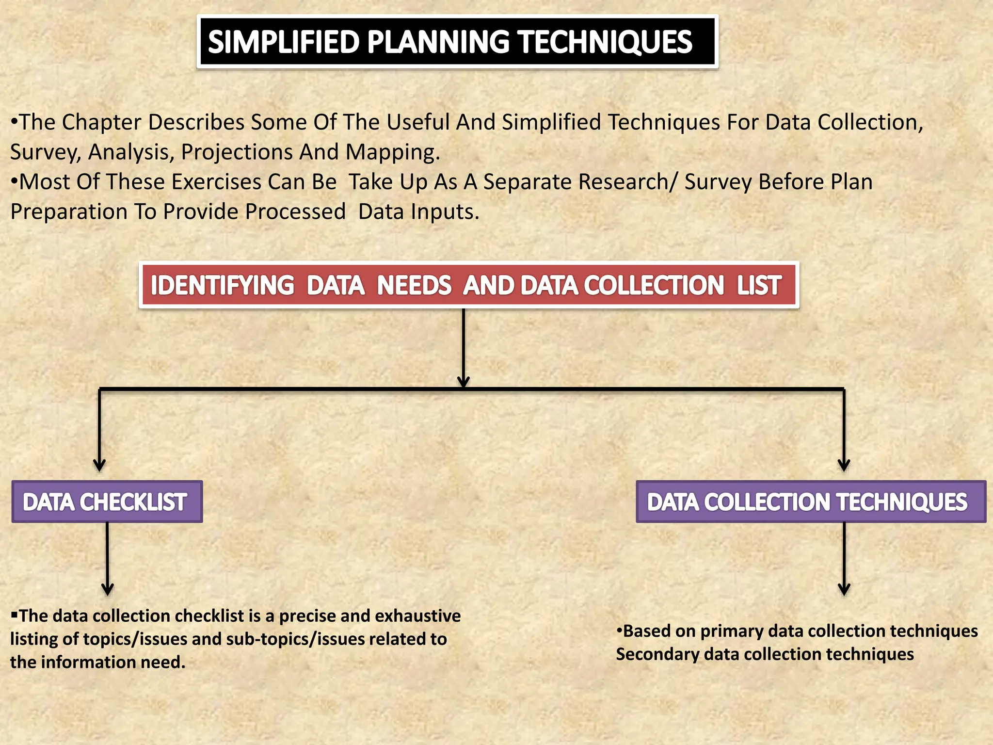
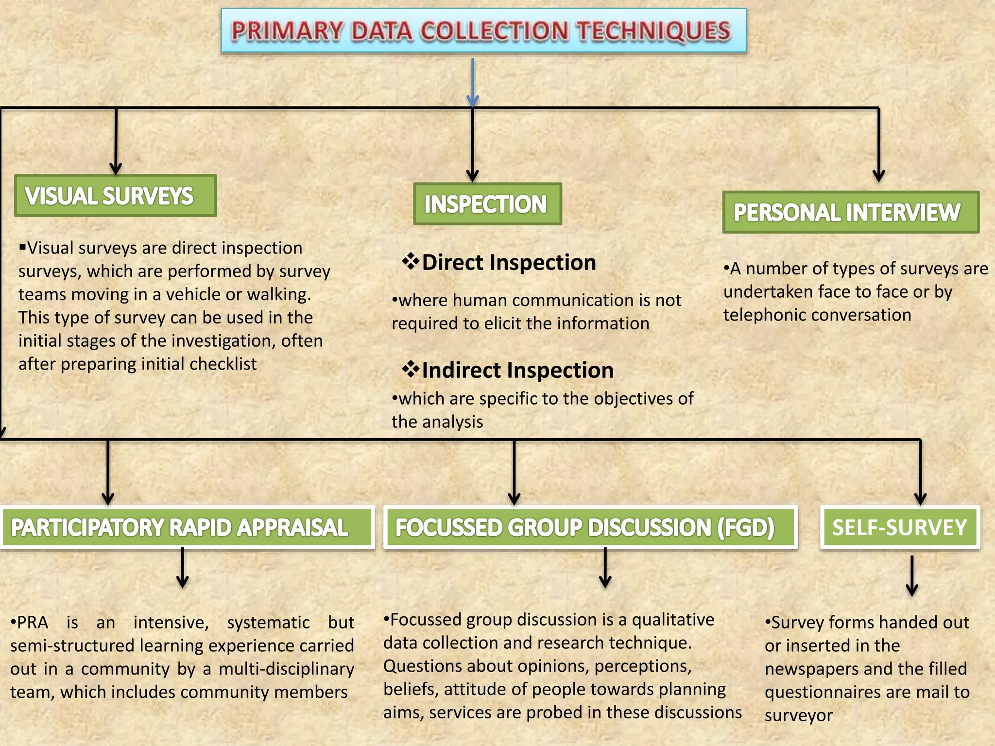
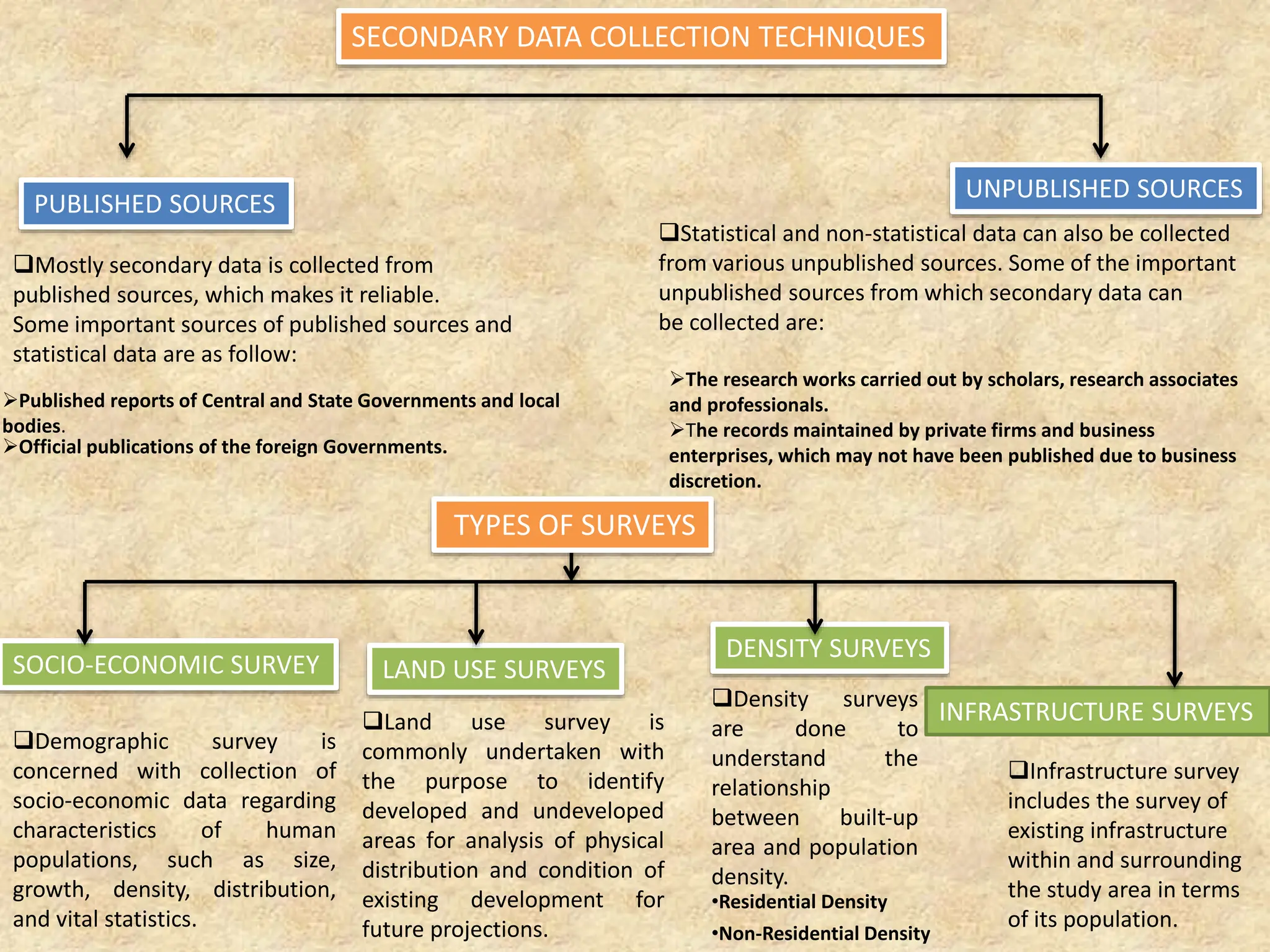
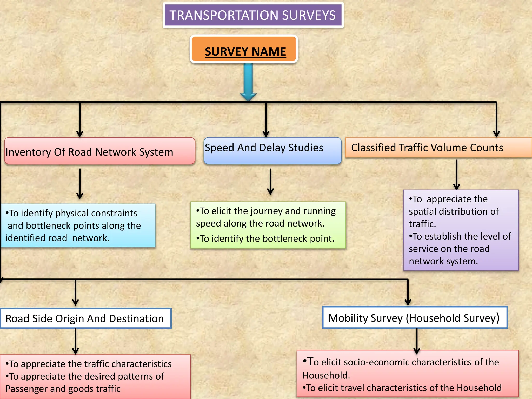
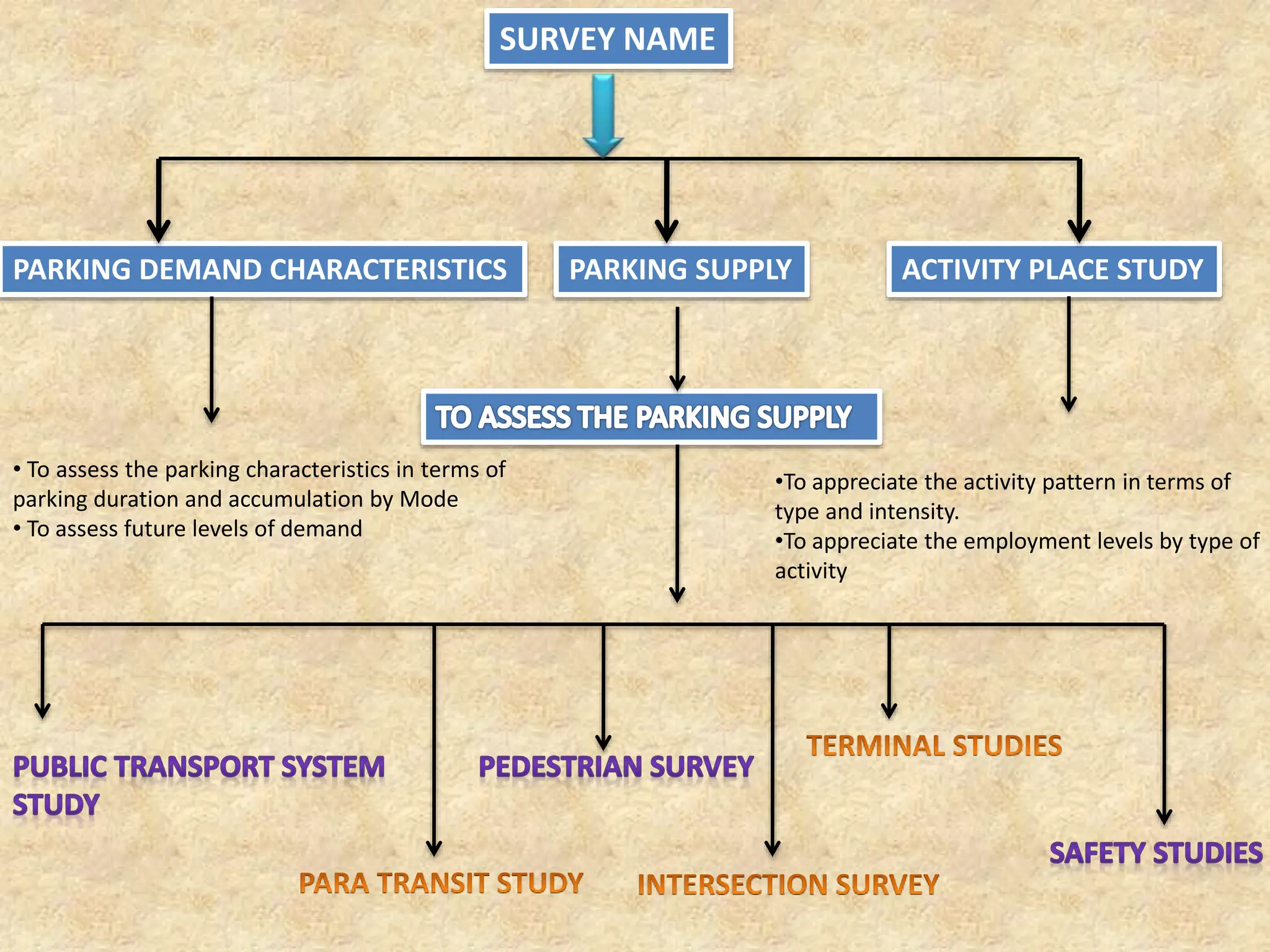
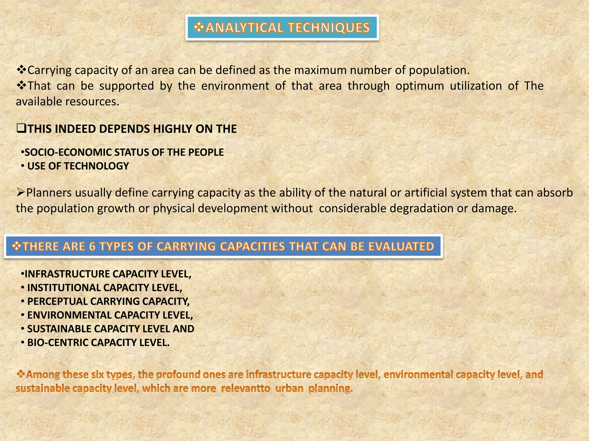
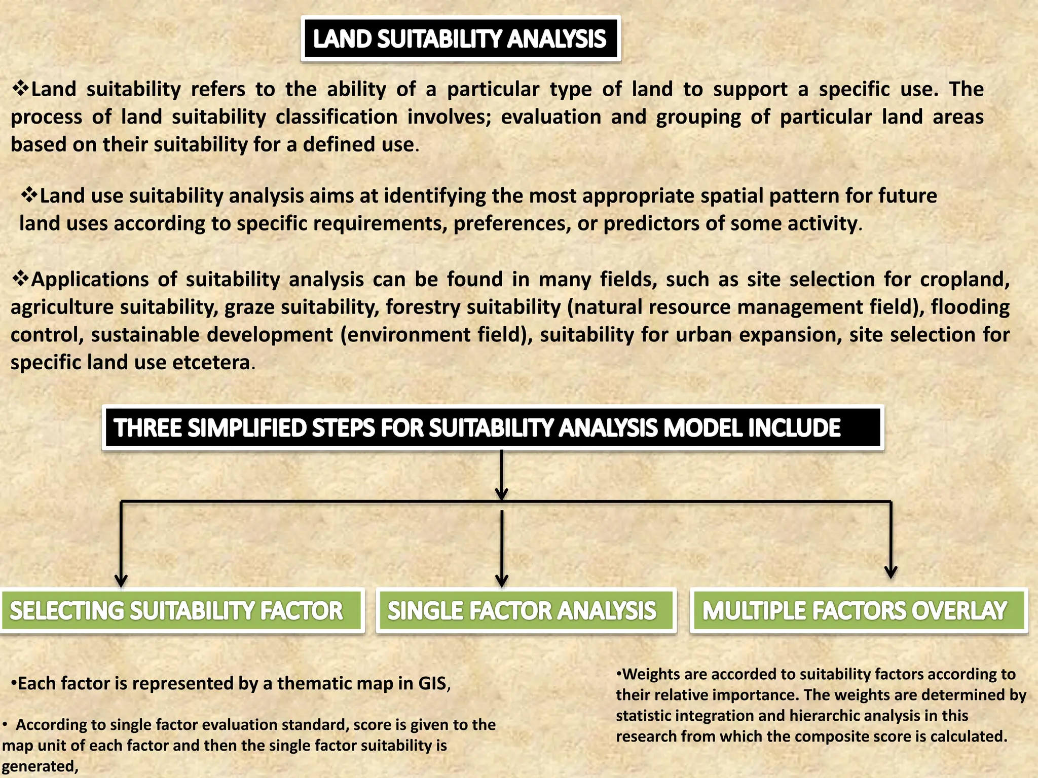
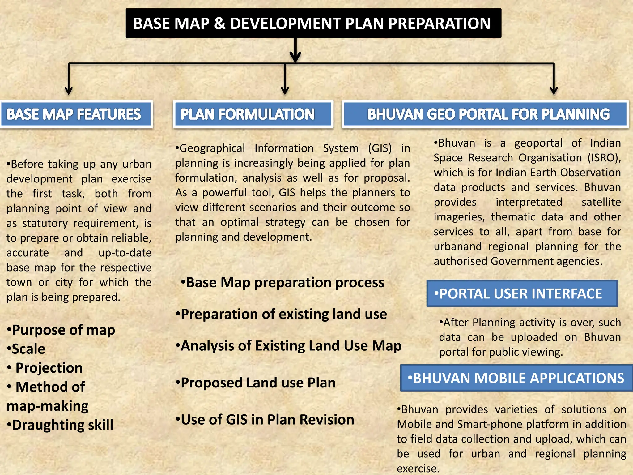
URDPFI, which stands for Urban and Regional Development Plans Formulation and Implementation, provides guidelines intended to streamline the planning process for urban and regional development in India. Chapter 7 of the URDPFI Guidelines focuses on data collection, survey methodologies, analysis, projections, and mapping essential for urban planning.
This chapter describes various techniques for collecting and processing data that planners need to create effective urban development plans. It includes simplified methods for conducting surveys, analyzing collected data, and using this information to make informed projections and mapping decisions. The chapter emphasizes the importance of having accurate and comprehensive data to support the formulation of regional and urban development plans [[❞]](http://cdn.cseindia.org/userfiles/URDPFI.pdf#:~:text=URL%3A%20http%3A%2F%2Fcdn.cseindia.org%2Fuserfiles%2FURDPFI.pdf%0AVisible%3A%200%25%20) [[❞]](https://mohua.gov.in/cms/urdpfi-guidelines.php).
For more detailed information, you can refer to the [URDPFI Guidelines document](http://cdn.cseindia.org/userfiles/URDPFI.pdf) [[❞]](http://cdn.cseindia.org/userfiles/URDPFI.pdf#:~:text=URL%3A%20http%3A%2F%2Fcdn.cseindia.org%2Fuserfiles%2FURDPFI.pdf%0AVisible%3A%200%25%20).
This document provides an overview of techniques for data collection, analysis, mapping, and development planning for urban and regional plans. It describes primary and secondary data collection methods including surveys, published/unpublished sources, and mapping. Key steps in the planning process are outlined, such as land use analysis, population and economic projections, suitability analysis, infrastructure assessments, and creating base maps. The use of GIS and geospatial portals like Bhuvan are also discussed for analyzing data, creating scenarios, and disseminating plans.
This document discusses simplified planning techniques for data collection, analysis, and mapping. It outlines methods for identifying data needs through checklists and collecting primary data through surveys, interviews, and direct observation. Rapid assessment techniques are recommended over lengthy questionnaires. Secondary data sources like government reports are also discussed. Analysis techniques should consider multiple parameters, handle large data, and produce visual outputs. Surveys of land use, infrastructure, transportation, socio-economics are important. Threshold and density analyses are outlined to project growth and capacity. Simplified reporting with clear objectives and contents is emphasized.
The document discusses different types of surveys: landscape surveys, transportation surveys, and service surveys. A landscape survey involves both field surveys and desk-based research to understand the development of an area. Transportation surveys collect data on travel patterns, transportation infrastructure, and land use to inform transportation planning. Service surveys gather customer feedback to measure satisfaction and identify ways to improve products and services. The document provides examples of methods used in each type of survey, such as home interviews, on-site counts, questionnaires, and open-text questions.
The document discusses environmental design and the planning process. It covers key topics such as:
1. The planning process involves analysis, synthesis, evaluation, and implementation to shape the built environment.
2. Environmental design principles include considering places before buildings, mixing land uses, designing at a human scale, and catering to all community members.
3. Site analysis involves gathering data on the physical site, surrounding context, and regulatory requirements to inform preliminary site planning and design concepts.
Transportation planning involves preparing for the movement of people and goods by defining transportation needs, developing transportation systems, and monitoring impacts. The document outlines the definition, functions, elements, process, principles, and studies involved in transportation planning. Transportation planning aims to identify transportation needs, design effective systems, and influence land use development through comprehensive, long-term planning. Key aspects of the planning process include defining problems and solutions, analyzing alternatives, and selecting optimal projects based on objectives.
The document discusses land use models and their relationship to transportation planning. It covers several topics:
- Land use and transportation are interrelated, with land use determining trip generation and transportation influencing land development.
- Early land use models included simple allocation techniques, density gradients, and accessibility-based approaches. Intermediate era models built on these with interactions between land use and transportation.
- Modern era models better represent demand and supply with dynamic allocation of population, housing, jobs, and land uses based on travel costs, accessibility, and development plans. They allow testing of various transportation and land use policies.
Baseline study survey on infrastructure projects in nepalBhim Upadhyaya
The document provides information on baseline studies for infrastructure development projects in Nepal. It defines a baseline study as a cross-sectional survey that quantifies the current status of a situation in a given population. It aims to measure the distribution of variables at a single point in time. The baseline establishes starting values that can be compared to endline data to assess changes resulting from a project. The document outlines the key components of conducting a baseline study, including objectives, research methodology, data collection and analysis.
This document provides a guide for conducting a city-wide assessment of public spaces. It outlines a four-part process for assessment: (1) pre-field work, (2) data collection and quality checks, (3) reporting, and (4) post-assessment. The goal is to understand a city's public space network, distribution, accessibility, quantity, and quality to inform public space policy. It provides steps for each part, including developing maps and statistics, validation workshops, and a final report with findings and recommendations. The guide is intended to help local governments better plan for and manage their public space networks.
Regional planning concept in tourism planning.pptxLaboni16
It is a presentation on planning for tourism region
Here we explain different planning antecedents and histories, regional development hierarchy, planning approach, planning process, etc.
The document discusses land tools developed by GLTN (Global Land Tool Network). It describes the process of land tool development and provides examples of specific land tools, including the Social Tenure Domain Model (STDM) for capturing land rights data, Participatory and Inclusive Land Readjustment (PILaR) for city expansion, land-based financing tools, and the Gender Evaluation Criteria for assessing land tools' responsiveness to gender. The tools aim to improve access to land, security of tenure, land management, and land policy/legislation.
The document provides details about establishing a monitoring and evaluation (M&E) system for a water resources development project in Bangladesh. It discusses conducting a readiness assessment, agreeing on objectives and outcomes, selecting indicators and targets, and planning monitoring, data collection, analysis, and reporting. Key steps include establishing the M&E purpose, conducting a baseline study, developing an evaluation framework, and ensuring the necessary conditions and capacities are in place to support effective M&E.
The document outlines the basic cycle of the urban design process, which includes 9 steps: 1) identify issues and options, 2) state goals and priorities, 3) collect and interpret data through situational analysis, 4) prepare plans including site inspections, 5) draft implementation programs through synthesis, 6) evaluate plan impacts, 7) review and adopt plans, 8) review and adopt implementation programs, and 9) administer implementation. It provides details on collecting data, performing visual surveys, and analyzing issues for various components like natural resources, transportation, health facilities, and sanitation in Barangay Beverly Hills, Antipolo City.
This document discusses transportation and housing planning. It covers transportation plan components and development process, including evaluating needs, setting goals, and implementing solutions. Housing plans aim to address affordable housing and integration. Key elements include inventories, needs assessments, goals, and action plans. Goals target issues like costs, resources, preservation, and economic development. The implementation plan outlines strategies, resources, timetables, and responsibilities.
1. Environmental planning involves identifying elements of the environment like social, economic, physical, and political factors. It determines the current state, projects future interactions, and formulates plans and actions to achieve desired results.
2. Environmental planning is dynamic, cyclic, multi-disciplinary, continuous, time-bound, and comprehensive. It covers all aspects of human and natural environments and changes over time in response to new demands.
3. Key terms in environmental planning include programs, projects, sectors, and standards. Programs achieve sectoral objectives, projects develop resources within areas and time periods, sectors are community development sub-systems, and standards establish performance measures.
GIS can help improve the urban planning process in 3 key ways:
1) GIS creates a centralized database to store and organize all spatial and attribute data for a city, making it easier to access, analyze, and use for decision making.
2) Satellite images and GIS tools allow planners to rapidly map land use changes, identify areas for future development, and update infrastructure like roads over time.
3) GIS provides analysis capabilities like overlaying maps and proximity analysis that help planners experiment with development alternatives and make more rational, data-driven decisions.
Introduction to gis and its application gandhinagar
This document introduces Geographic Information Systems (GIS) and describes its components and applications. GIS is a collection of software, hardware, data, and personnel used to store, manipulate, analyze and present geospatial data. Its major objectives are to maximize efficiency, integrate multiple data sources, enable complex analysis, and minimize redundant data. A GIS has hardware, software, data, procedures, and personnel. It then discusses applications of GIS in transportation, water resource engineering, urban planning, construction, and analysis.
Elements of an Implementation - Orientated Planning ProcessYazid Hamoda
The document outlines the key elements of an implementation-oriented land use planning process, including:
1. Collection and analysis of data and information from various sources to understand the planning area.
2. Building capacity of stakeholders and clarifying rules through organization, agreements and trust-building.
3. Drawing up plans by assessing options and interventions using technical, social and organizational criteria.
GIS projects can be loaded onto mobile devices with the users' location live projected onto the project through the use of software platforms such as ArcGIS field maps.
Navigating projects (43:18)
Builders can actively map out and locate themselves during the construction phase of the project, which allows for more efficient project navigation. Builders can also make coordinate specific notes if necessary during construction.
More after construction support (44:11):
For farmers and landscape owners:
• Farmers can have their own field map of their irrigation systems.
o Easily navigate the irrigation design.
o Make coordinate specific pinpoints of any damage or breaks in the irrigation system.
o Can send harvesters and planters to specific locations.
o Can track harvest / planting progress by map.
• Landscape owners can have their own generated irrigation schedules to avoid overwatering and underwatering.
Transportation planning involves preparing for the movement of people and goods by identifying transportation needs, defining systems, and considering efficiency, quality, and equity. It uses several models and studies - including trip generation, distribution, modal split, and traffic assignment - to understand existing and future travel demand and develop an optimal transportation network. Common transportation studies in the planning process are origin-destination studies, traffic volume studies, speed studies, and parking studies, which provide key data for planning decisions.
This document provides an overview of regional and neighborhood planning. It discusses the purpose and components of regional plans, including defining the region, regional functional plans, and elements of a regional comprehensive plan such as population projections and transportation systems. It also covers descriptive studies undertaken in regional planning and common map components. The document then discusses neighborhood plans, including reasons for preparing them, common elements like housing and transportation, and the importance of an implementation framework.
The document discusses the fundamentals of comprehensive urban planning. It defines a comprehensive plan as an official statement that sets forth goals, analyzes existing conditions, and outlines policies to implement a vision for a community's future development over 20 years. Key elements of a comprehensive plan include land use, transportation, housing, economic development, community facilities, natural hazards, and agriculture. The plan provides guidance for public and private decisions to achieve a coordinated development pattern.
This document summarizes the key aspects of a master plan submitted for a settlement. It discusses:
1. The need for master plans arose due to unplanned growth of cities following industrialization and wars, which led to overcrowding and lack of infrastructure.
2. A master plan is a statutory document that guides the orderly development of a city over a horizon year through land use planning and regulations. It addresses issues like transportation, housing, employment and provision of utilities and services.
3. The key components of the master plan submitted include analyses of the existing conditions, projected population and land requirements, and development proposals to organize land use and infrastructure over the plan period. It provides guidelines for implementation and monitoring of
www.its.leeds.ac.uk/about/events/seminar-series
The economic and environmental dimensions of transport have been the subject of extensive academic research and have had a strong influence on transport policy and practice around the world. This is in stark contrast to the social dimension, which in general has been less widely researched, less well defined and generally much less influential in policy circles. However, there is now increased recognition by policymakers that new transport infrastructures can potentially have significant social and distributional impacts (SDIs) beyond those that are usually captured by traditional project appraisal methods. Currently, the methods for capturing these SDIs are under explored and the guidance provided through WebTAG analysis is as yet largely untested.
It is in this context that we were asked by Welsh Government to conduct a social and distributional analysis of a new section of the A465, studying the area surrounding the road both during its construction and after. Our talk will outline the integration of desk based quantitative and field work based qualitative methodologies used for the study and the rationale for these, and also present our key findings. We will also outline some of the challenges we faced in undertaking the analysis, and in turn reflect on some of the barriers to embedding effective SDI appraisals into policy practice. We will also reflect on the appropriateness of the WebTAG guidance for practice, and suggest ways in which these could be improved.
This document provides an overview of key concepts in town planning and planning processes. It defines town planning as ordering the use of land and infrastructure to maximize economy, convenience and beauty. Important concepts discussed include Ebenezer Howard's Garden City model, which aimed to combine benefits of urban and rural living; Patrick Geddes' triad focusing on the organic relationship between social, physical and economic environments; and neighborhood planning by Clarence Perry. The document also outlines the roles of planners, aims of town planning, types of surveys and plans, and the planning process.
This document provides an overview of the fundamentals of urban planning, as presented in the first lecture of an engineering course. It defines key planning concepts like plans, plan making, and planning. It examines who planners are and why planning is needed due to the interconnectedness and complexity of communities. It outlines the typical structure of a plan, including elements like goals, objectives, data needs, and implementation. The document also provides examples of goals and objectives from the urban plan of Nantucket, Massachusetts.
The document discusses the International Hydropower Association (IHA) and its Sustainability Assessment Protocol (SAP) for evaluating hydropower projects. It also describes various methods for conducting environmental impact assessments (EIA), including checklists, matrices, networks, overlays, and geographical information systems (GIS). The matrix method involves listing project actions and potential environmental impacts to identify interactions. Overlays and GIS involve mapping environmental features and project plans to predict impacts. The document concludes that IHA's SAP and EIA methods provide tools for sustainable hydropower development and measuring environmental changes.
हिंदी वर्णमाला पीपीटी, hindi alphabet PPT presentation, hindi varnamala PPT, Hindi Varnamala pdf, हिंदी स्वर, हिंदी व्यंजन, sikhiye hindi varnmala, dr. mulla adam ali, hindi language and literature, hindi alphabet with drawing, hindi alphabet pdf, hindi varnamala for childrens, hindi language, hindi varnamala practice for kids, https://www.drmullaadamali.com
How to Setup Warehouse & Location in Odoo 17 InventoryCeline George
In this slide, we'll explore how to set up warehouses and locations in Odoo 17 Inventory. This will help us manage our stock effectively, track inventory levels, and streamline warehouse operations.
More Related Content
Similar to Taskin urdpfichapter7-. Urban and regional development plans formulatio and implementation
Regional planning concept in tourism planning.pptxLaboni16
It is a presentation on planning for tourism region
Here we explain different planning antecedents and histories, regional development hierarchy, planning approach, planning process, etc.
The document discusses land tools developed by GLTN (Global Land Tool Network). It describes the process of land tool development and provides examples of specific land tools, including the Social Tenure Domain Model (STDM) for capturing land rights data, Participatory and Inclusive Land Readjustment (PILaR) for city expansion, land-based financing tools, and the Gender Evaluation Criteria for assessing land tools' responsiveness to gender. The tools aim to improve access to land, security of tenure, land management, and land policy/legislation.
The document provides details about establishing a monitoring and evaluation (M&E) system for a water resources development project in Bangladesh. It discusses conducting a readiness assessment, agreeing on objectives and outcomes, selecting indicators and targets, and planning monitoring, data collection, analysis, and reporting. Key steps include establishing the M&E purpose, conducting a baseline study, developing an evaluation framework, and ensuring the necessary conditions and capacities are in place to support effective M&E.
The document outlines the basic cycle of the urban design process, which includes 9 steps: 1) identify issues and options, 2) state goals and priorities, 3) collect and interpret data through situational analysis, 4) prepare plans including site inspections, 5) draft implementation programs through synthesis, 6) evaluate plan impacts, 7) review and adopt plans, 8) review and adopt implementation programs, and 9) administer implementation. It provides details on collecting data, performing visual surveys, and analyzing issues for various components like natural resources, transportation, health facilities, and sanitation in Barangay Beverly Hills, Antipolo City.
This document discusses transportation and housing planning. It covers transportation plan components and development process, including evaluating needs, setting goals, and implementing solutions. Housing plans aim to address affordable housing and integration. Key elements include inventories, needs assessments, goals, and action plans. Goals target issues like costs, resources, preservation, and economic development. The implementation plan outlines strategies, resources, timetables, and responsibilities.
1. Environmental planning involves identifying elements of the environment like social, economic, physical, and political factors. It determines the current state, projects future interactions, and formulates plans and actions to achieve desired results.
2. Environmental planning is dynamic, cyclic, multi-disciplinary, continuous, time-bound, and comprehensive. It covers all aspects of human and natural environments and changes over time in response to new demands.
3. Key terms in environmental planning include programs, projects, sectors, and standards. Programs achieve sectoral objectives, projects develop resources within areas and time periods, sectors are community development sub-systems, and standards establish performance measures.
GIS can help improve the urban planning process in 3 key ways:
1) GIS creates a centralized database to store and organize all spatial and attribute data for a city, making it easier to access, analyze, and use for decision making.
2) Satellite images and GIS tools allow planners to rapidly map land use changes, identify areas for future development, and update infrastructure like roads over time.
3) GIS provides analysis capabilities like overlaying maps and proximity analysis that help planners experiment with development alternatives and make more rational, data-driven decisions.
Introduction to gis and its application gandhinagar
This document introduces Geographic Information Systems (GIS) and describes its components and applications. GIS is a collection of software, hardware, data, and personnel used to store, manipulate, analyze and present geospatial data. Its major objectives are to maximize efficiency, integrate multiple data sources, enable complex analysis, and minimize redundant data. A GIS has hardware, software, data, procedures, and personnel. It then discusses applications of GIS in transportation, water resource engineering, urban planning, construction, and analysis.
Elements of an Implementation - Orientated Planning ProcessYazid Hamoda
The document outlines the key elements of an implementation-oriented land use planning process, including:
1. Collection and analysis of data and information from various sources to understand the planning area.
2. Building capacity of stakeholders and clarifying rules through organization, agreements and trust-building.
3. Drawing up plans by assessing options and interventions using technical, social and organizational criteria.
GIS projects can be loaded onto mobile devices with the users' location live projected onto the project through the use of software platforms such as ArcGIS field maps.
Navigating projects (43:18)
Builders can actively map out and locate themselves during the construction phase of the project, which allows for more efficient project navigation. Builders can also make coordinate specific notes if necessary during construction.
More after construction support (44:11):
For farmers and landscape owners:
• Farmers can have their own field map of their irrigation systems.
o Easily navigate the irrigation design.
o Make coordinate specific pinpoints of any damage or breaks in the irrigation system.
o Can send harvesters and planters to specific locations.
o Can track harvest / planting progress by map.
• Landscape owners can have their own generated irrigation schedules to avoid overwatering and underwatering.
Transportation planning involves preparing for the movement of people and goods by identifying transportation needs, defining systems, and considering efficiency, quality, and equity. It uses several models and studies - including trip generation, distribution, modal split, and traffic assignment - to understand existing and future travel demand and develop an optimal transportation network. Common transportation studies in the planning process are origin-destination studies, traffic volume studies, speed studies, and parking studies, which provide key data for planning decisions.
This document provides an overview of regional and neighborhood planning. It discusses the purpose and components of regional plans, including defining the region, regional functional plans, and elements of a regional comprehensive plan such as population projections and transportation systems. It also covers descriptive studies undertaken in regional planning and common map components. The document then discusses neighborhood plans, including reasons for preparing them, common elements like housing and transportation, and the importance of an implementation framework.
The document discusses the fundamentals of comprehensive urban planning. It defines a comprehensive plan as an official statement that sets forth goals, analyzes existing conditions, and outlines policies to implement a vision for a community's future development over 20 years. Key elements of a comprehensive plan include land use, transportation, housing, economic development, community facilities, natural hazards, and agriculture. The plan provides guidance for public and private decisions to achieve a coordinated development pattern.
This document summarizes the key aspects of a master plan submitted for a settlement. It discusses:
1. The need for master plans arose due to unplanned growth of cities following industrialization and wars, which led to overcrowding and lack of infrastructure.
2. A master plan is a statutory document that guides the orderly development of a city over a horizon year through land use planning and regulations. It addresses issues like transportation, housing, employment and provision of utilities and services.
3. The key components of the master plan submitted include analyses of the existing conditions, projected population and land requirements, and development proposals to organize land use and infrastructure over the plan period. It provides guidelines for implementation and monitoring of
www.its.leeds.ac.uk/about/events/seminar-series
The economic and environmental dimensions of transport have been the subject of extensive academic research and have had a strong influence on transport policy and practice around the world. This is in stark contrast to the social dimension, which in general has been less widely researched, less well defined and generally much less influential in policy circles. However, there is now increased recognition by policymakers that new transport infrastructures can potentially have significant social and distributional impacts (SDIs) beyond those that are usually captured by traditional project appraisal methods. Currently, the methods for capturing these SDIs are under explored and the guidance provided through WebTAG analysis is as yet largely untested.
It is in this context that we were asked by Welsh Government to conduct a social and distributional analysis of a new section of the A465, studying the area surrounding the road both during its construction and after. Our talk will outline the integration of desk based quantitative and field work based qualitative methodologies used for the study and the rationale for these, and also present our key findings. We will also outline some of the challenges we faced in undertaking the analysis, and in turn reflect on some of the barriers to embedding effective SDI appraisals into policy practice. We will also reflect on the appropriateness of the WebTAG guidance for practice, and suggest ways in which these could be improved.
This document provides an overview of key concepts in town planning and planning processes. It defines town planning as ordering the use of land and infrastructure to maximize economy, convenience and beauty. Important concepts discussed include Ebenezer Howard's Garden City model, which aimed to combine benefits of urban and rural living; Patrick Geddes' triad focusing on the organic relationship between social, physical and economic environments; and neighborhood planning by Clarence Perry. The document also outlines the roles of planners, aims of town planning, types of surveys and plans, and the planning process.
This document provides an overview of the fundamentals of urban planning, as presented in the first lecture of an engineering course. It defines key planning concepts like plans, plan making, and planning. It examines who planners are and why planning is needed due to the interconnectedness and complexity of communities. It outlines the typical structure of a plan, including elements like goals, objectives, data needs, and implementation. The document also provides examples of goals and objectives from the urban plan of Nantucket, Massachusetts.
The document discusses the International Hydropower Association (IHA) and its Sustainability Assessment Protocol (SAP) for evaluating hydropower projects. It also describes various methods for conducting environmental impact assessments (EIA), including checklists, matrices, networks, overlays, and geographical information systems (GIS). The matrix method involves listing project actions and potential environmental impacts to identify interactions. Overlays and GIS involve mapping environmental features and project plans to predict impacts. The document concludes that IHA's SAP and EIA methods provide tools for sustainable hydropower development and measuring environmental changes.
हिंदी वर्णमाला पीपीटी, hindi alphabet PPT presentation, hindi varnamala PPT, Hindi Varnamala pdf, हिंदी स्वर, हिंदी व्यंजन, sikhiye hindi varnmala, dr. mulla adam ali, hindi language and literature, hindi alphabet with drawing, hindi alphabet pdf, hindi varnamala for childrens, hindi language, hindi varnamala practice for kids, https://www.drmullaadamali.com
How to Setup Warehouse & Location in Odoo 17 InventoryCeline George
In this slide, we'll explore how to set up warehouses and locations in Odoo 17 Inventory. This will help us manage our stock effectively, track inventory levels, and streamline warehouse operations.
How to Make a Field Mandatory in Odoo 17Celine George
In Odoo, making a field required can be done through both Python code and XML views. When you set the required attribute to True in Python code, it makes the field required across all views where it's used. Conversely, when you set the required attribute in XML views, it makes the field required only in the context of that particular view.
LAND USE LAND COVER AND NDVI OF MIRZAPUR DISTRICT, UPRAHUL
This Dissertation explores the particular circumstances of Mirzapur, a region located in the
core of India. Mirzapur, with its varied terrains and abundant biodiversity, offers an optimal
environment for investigating the changes in vegetation cover dynamics. Our study utilizes
advanced technologies such as GIS (Geographic Information Systems) and Remote sensing to
analyze the transformations that have taken place over the course of a decade.
The complex relationship between human activities and the environment has been the focus
of extensive research and worry. As the global community grapples with swift urbanization,
population expansion, and economic progress, the effects on natural ecosystems are becoming
more evident. A crucial element of this impact is the alteration of vegetation cover, which plays a
significant role in maintaining the ecological equilibrium of our planet.Land serves as the foundation for all human activities and provides the necessary materials for
these activities. As the most crucial natural resource, its utilization by humans results in different
'Land uses,' which are determined by both human activities and the physical characteristics of the
land.
The utilization of land is impacted by human needs and environmental factors. In countries
like India, rapid population growth and the emphasis on extensive resource exploitation can lead
to significant land degradation, adversely affecting the region's land cover.
Therefore, human intervention has significantly influenced land use patterns over many
centuries, evolving its structure over time and space. In the present era, these changes have
accelerated due to factors such as agriculture and urbanization. Information regarding land use and
cover is essential for various planning and management tasks related to the Earth's surface,
providing crucial environmental data for scientific, resource management, policy purposes, and
diverse human activities.
Accurate understanding of land use and cover is imperative for the development planning
of any area. Consequently, a wide range of professionals, including earth system scientists, land
and water managers, and urban planners, are interested in obtaining data on land use and cover
changes, conversion trends, and other related patterns. The spatial dimensions of land use and
cover support policymakers and scientists in making well-informed decisions, as alterations in
these patterns indicate shifts in economic and social conditions. Monitoring such changes with the
help of Advanced technologies like Remote Sensing and Geographic Information Systems is
crucial for coordinated efforts across different administrative levels. Advanced technologies like
Remote Sensing and Geographic Information Systems
9
Changes in vegetation cover refer to variations in the distribution, composition, and overall
structure of plant communities across different temporal and spatial scales. These changes can
occur natural.
ISO/IEC 27001, ISO/IEC 42001, and GDPR: Best Practices for Implementation and...PECB
Denis is a dynamic and results-driven Chief Information Officer (CIO) with a distinguished career spanning information systems analysis and technical project management. With a proven track record of spearheading the design and delivery of cutting-edge Information Management solutions, he has consistently elevated business operations, streamlined reporting functions, and maximized process efficiency.
Certified as an ISO/IEC 27001: Information Security Management Systems (ISMS) Lead Implementer, Data Protection Officer, and Cyber Risks Analyst, Denis brings a heightened focus on data security, privacy, and cyber resilience to every endeavor.
His expertise extends across a diverse spectrum of reporting, database, and web development applications, underpinned by an exceptional grasp of data storage and virtualization technologies. His proficiency in application testing, database administration, and data cleansing ensures seamless execution of complex projects.
What sets Denis apart is his comprehensive understanding of Business and Systems Analysis technologies, honed through involvement in all phases of the Software Development Lifecycle (SDLC). From meticulous requirements gathering to precise analysis, innovative design, rigorous development, thorough testing, and successful implementation, he has consistently delivered exceptional results.
Throughout his career, he has taken on multifaceted roles, from leading technical project management teams to owning solutions that drive operational excellence. His conscientious and proactive approach is unwavering, whether he is working independently or collaboratively within a team. His ability to connect with colleagues on a personal level underscores his commitment to fostering a harmonious and productive workplace environment.
Date: May 29, 2024
Tags: Information Security, ISO/IEC 27001, ISO/IEC 42001, Artificial Intelligence, GDPR
-------------------------------------------------------------------------------
Find out more about ISO training and certification services
Training: ISO/IEC 27001 Information Security Management System - EN | PECB
ISO/IEC 42001 Artificial Intelligence Management System - EN | PECB
General Data Protection Regulation (GDPR) - Training Courses - EN | PECB
Webinars: https://pecb.com/webinars
Article: https://pecb.com/article
-------------------------------------------------------------------------------
For more information about PECB:
Website: https://pecb.com/
LinkedIn: https://www.linkedin.com/company/pecb/
Facebook: https://www.facebook.com/PECBInternational/
Slideshare: http://www.slideshare.net/PECBCERTIFICATION
Philippine Edukasyong Pantahanan at Pangkabuhayan (EPP) CurriculumMJDuyan
(𝐓𝐋𝐄 𝟏𝟎𝟎) (𝐋𝐞𝐬𝐬𝐨𝐧 𝟏)-𝐏𝐫𝐞𝐥𝐢𝐦𝐬
𝐃𝐢𝐬𝐜𝐮𝐬𝐬 𝐭𝐡𝐞 𝐄𝐏𝐏 𝐂𝐮𝐫𝐫𝐢𝐜𝐮𝐥𝐮𝐦 𝐢𝐧 𝐭𝐡𝐞 𝐏𝐡𝐢𝐥𝐢𝐩𝐩𝐢𝐧𝐞𝐬:
- Understand the goals and objectives of the Edukasyong Pantahanan at Pangkabuhayan (EPP) curriculum, recognizing its importance in fostering practical life skills and values among students. Students will also be able to identify the key components and subjects covered, such as agriculture, home economics, industrial arts, and information and communication technology.
𝐄𝐱𝐩𝐥𝐚𝐢𝐧 𝐭𝐡𝐞 𝐍𝐚𝐭𝐮𝐫𝐞 𝐚𝐧𝐝 𝐒𝐜𝐨𝐩𝐞 𝐨𝐟 𝐚𝐧 𝐄𝐧𝐭𝐫𝐞𝐩𝐫𝐞𝐧𝐞𝐮𝐫:
-Define entrepreneurship, distinguishing it from general business activities by emphasizing its focus on innovation, risk-taking, and value creation. Students will describe the characteristics and traits of successful entrepreneurs, including their roles and responsibilities, and discuss the broader economic and social impacts of entrepreneurial activities on both local and global scales.
Gender and Mental Health - Counselling and Family Therapy Applications and In...PsychoTech Services
A proprietary approach developed by bringing together the best of learning theories from Psychology, design principles from the world of visualization, and pedagogical methods from over a decade of training experience, that enables you to: Learn better, faster!
Main Java[All of the Base Concepts}.docxadhitya5119
This is part 1 of my Java Learning Journey. This Contains Custom methods, classes, constructors, packages, multithreading , try- catch block, finally block and more.
This document provides an overview of wound healing, its functions, stages, mechanisms, factors affecting it, and complications.
A wound is a break in the integrity of the skin or tissues, which may be associated with disruption of the structure and function.
Healing is the body’s response to injury in an attempt to restore normal structure and functions.
Healing can occur in two ways: Regeneration and Repair
There are 4 phases of wound healing: hemostasis, inflammation, proliferation, and remodeling. This document also describes the mechanism of wound healing. Factors that affect healing include infection, uncontrolled diabetes, poor nutrition, age, anemia, the presence of foreign bodies, etc.
Complications of wound healing like infection, hyperpigmentation of scar, contractures, and keloid formation.
Walmart Business+ and Spark Good for Nonprofits.pdfTechSoup
"Learn about all the ways Walmart supports nonprofit organizations.
You will hear from Liz Willett, the Head of Nonprofits, and hear about what Walmart is doing to help nonprofits, including Walmart Business and Spark Good. Walmart Business+ is a new offer for nonprofits that offers discounts and also streamlines nonprofits order and expense tracking, saving time and money.
The webinar may also give some examples on how nonprofits can best leverage Walmart Business+.
The event will cover the following::
Walmart Business + (https://business.walmart.com/plus) is a new shopping experience for nonprofits, schools, and local business customers that connects an exclusive online shopping experience to stores. Benefits include free delivery and shipping, a 'Spend Analytics” feature, special discounts, deals and tax-exempt shopping.
Special TechSoup offer for a free 180 days membership, and up to $150 in discounts on eligible orders.
Spark Good (walmart.com/sparkgood) is a charitable platform that enables nonprofits to receive donations directly from customers and associates.
Answers about how you can do more with Walmart!"
RHEOLOGY Physical pharmaceutics-II notes for B.pharm 4th sem students
Taskin urdpfichapter7-. Urban and regional development plans formulatio and implementation
1. URBAN AND REGIONAL DEVELOPMENT PLANS
FORMULATION AND IMPLEMENTATION
-By
Taskin C
Harshitha
2. •The Chapter Describes Some Of The Useful And Simplified Techniques For Data Collection,
Survey, Analysis, Projections And Mapping.
•Most Of These Exercises Can Be Take Up As A Separate Research/ Survey Before Plan
Preparation To Provide Processed Data Inputs.
The data collection checklist is a precise and exhaustive
listing of topics/issues and sub‐topics/issues related to
the information need.
•Based on primary data collection techniques
Secondary data collection techniques
3. SELF‐SURVEY
Visual surveys are direct inspection
surveys, which are performed by survey
teams moving in a vehicle or walking.
This type of survey can be used in the
initial stages of the investigation, often
after preparing initial checklist
Direct Inspection
Indirect Inspection
•where human communication is not
required to elicit the information
•which are specific to the objectives of
the analysis
•A number of types of surveys are
undertaken face to face or by
telephonic conversation
•PRA is an intensive, systematic but
semi‐structured learning experience carried
out in a community by a multi‐disciplinary
team, which includes community members
•Focussed group discussion is a qualitative
data collection and research technique.
Questions about opinions, perceptions,
beliefs, attitude of people towards planning
aims, services are probed in these discussions
•Survey forms handed out
or inserted in the
newspapers and the filled
questionnaires are mail to
surveyor
4. SECONDARY DATA COLLECTION TECHNIQUES
PUBLISHED SOURCES
UNPUBLISHED SOURCES
Mostly secondary data is collected from
published sources, which makes it reliable.
Some important sources of published sources and
statistical data are as follow:
Statistical and non‐statistical data can also be collected
from various unpublished sources. Some of the important
unpublished sources from which secondary data can
be collected are:
Published reports of Central and State Governments and local
bodies.
Official publications of the foreign Governments.
The research works carried out by scholars, research associates
and professionals.
The records maintained by private firms and business
enterprises, which may not have been published due to business
discretion.
TYPES OF SURVEYS
SOCIO‐ECONOMIC SURVEY LAND USE SURVEYS
DENSITY SURVEYS
INFRASTRUCTURE SURVEYS
Demographic survey is
concerned with collection of
socio‐economic data regarding
characteristics of human
populations, such as size,
growth, density, distribution,
and vital statistics.
Land use survey is
commonly undertaken with
the purpose to identify
developed and undeveloped
areas for analysis of physical
distribution and condition of
existing development for
future projections.
Density surveys
are done to
understand the
relationship
between built‐up
area and population
density.
•Residential Density
•Non‐Residential Density
Infrastructure survey
includes the survey of
existing infrastructure
within and surrounding
the study area in terms
of its population.
5. TRANSPORTATION SURVEYS
SURVEY NAME
Inventory Of Road Network System Speed And Delay Studies Classified Traffic Volume Counts
Road Side Origin And Destination
•To identify physical constraints
and bottleneck points along the
identified road network.
•To elicit the journey and running
speed along the road network.
•To identify the bottleneck point.
•To appreciate the
spatial distribution of
traffic.
•To establish the level of
service on the road
network system.
Mobility Survey (Household Survey)
•To appreciate the traffic characteristics
•To appreciate the desired patterns of
Passenger and goods traffic
•To elicit socio‐economic characteristics of the
Household.
•To elicit travel characteristics of the Household
6. PARKING DEMAND CHARACTERISTICS PARKING SUPPLY ACTIVITY PLACE STUDY
•To appreciate the activity pattern in terms of
type and intensity.
•To appreciate the employment levels by type of
activity
• To assess the parking characteristics in terms of
parking duration and accumulation by Mode
• To assess future levels of demand
SURVEY NAME
7. Carrying capacity of an area can be defined as the maximum number of population.
That can be supported by the environment of that area through optimum utilization of The
available resources.
THIS INDEED DEPENDS HIGHLY ON THE
•SOCIO‐ECONOMIC STATUS OF THE PEOPLE
• USE OF TECHNOLOGY
Planners usually define carrying capacity as the ability of the natural or artificial system that can absorb
the population growth or physical development without considerable degradation or damage.
•INFRASTRUCTURE CAPACITY LEVEL,
• INSTITUTIONAL CAPACITY LEVEL,
• PERCEPTUAL CARRYING CAPACITY,
• ENVIRONMENTAL CAPACITY LEVEL,
• SUSTAINABLE CAPACITY LEVEL AND
• BIO‐CENTRIC CAPACITY LEVEL.
8. Land suitability refers to the ability of a particular type of land to support a specific use. The
process of land suitability classification involves; evaluation and grouping of particular land areas
based on their suitability for a defined use.
Land use suitability analysis aims at identifying the most appropriate spatial pattern for future
land uses according to specific requirements, preferences, or predictors of some activity.
Applications of suitability analysis can be found in many fields, such as site selection for cropland,
agriculture suitability, graze suitability, forestry suitability (natural resource management field), flooding
control, sustainable development (environment field), suitability for urban expansion, site selection for
specific land use etcetera.
•Each factor is represented by a thematic map in GIS,
• According to single factor evaluation standard, score is given to the
map unit of each factor and then the single factor suitability is
generated,
•Weights are accorded to suitability factors according to
their relative importance. The weights are determined by
statistic integration and hierarchic analysis in this
research from which the composite score is calculated.
9. •the demand for water, power and
waste disposal facilities; housing,
open spaces and schools; the supply
of labour; spending power available
for the retail trade, the numbers of
private cars to be expected, possible
recreational demands ‐all can be
estimated from the projected
population.
•Mathematical and Direct Methods
•Employment Method
•Ratio Methods
•Migration and Natural increase Method
•The Cohort Survival Methods
•Matrix Methods
•The likely demands of land
development rest on various
types of economic activities,its
scale, its possible location within
a city or a city region and broad
relationships between these
activities.
•Simple Extrapolation
•Productivity Method
•Projections by Sectors of Economy
•Economic Base Method
•Ratio Method
•Input Output Methods
•Social or Regional Accounts Method
•National product is a measure in
monetary terms of the volume of
all goods and services produced
by an economy during a given
period of time, accounted without
duplication. It is measured by
three approaches, namely the
production, income, and
expenditure.
•Production approach
•Expenditure approach
10. MAPPING
The scale of map used depends
upon the size of the planning
area and the coverage and
extent of the information . the
scale of maps for different types
of planning exercises at various
levels may be selected out of
the range indicated .
•Perspective Plan
•Regional Plan
•Local Area Plan/
Special Purpose Plan
Maps contain lots of spatial
data for the planning of
urban and regional areas.
Depending upon the
requirement of study and
availability of data, features
can be selected and
presented through map.
•Physical
•Planning and Administrative
•History of development
•Climate
•Tourism
•Hazard prone
•Demography
•Economic and Social
development
•Infrastructure
•Transportation
Procedure to retrieve data by
permissions, which is not available in
the public forum
are given below:
TOPO SHEETS
Unrestricted topographical/ city guide
maps published by Survey of India are
available for sale. The standard
topographical maps on scale 1:25000,
1:50000 and 1:250,000 and city guide
maps published for selected
towns/cities are useful for urban
development plan purpose.
AERIAL PHOTOGRAPHY
Information regarding area of interest for
aerial photography, its scale and cost rates
can be obtained from Surveyor General’s
Office, Dehradun or the Directorate of
Survey (Air), New Delhi.
11. BASE MAP & DEVELOPMENT PLAN PREPARATION
•Base Map preparation process
•Before taking up any urban
development plan exercise
the first task, both from
planning point of view and
as statutory requirement, is
to prepare or obtain reliable,
accurate and up‐to‐date
base map for the respective
town or city for which the
plan is being prepared.
•Purpose of map
•Scale
• Projection
• Method of
map‐making
•Draughting skill
•Geographical Information System (GIS) in
planning is increasingly being applied for plan
formulation, analysis as well as for proposal.
As a powerful tool, GIS helps the planners to
view different scenarios and their outcome so
that an optimal strategy can be chosen for
planning and development.
•Preparation of existing land use
•Analysis of Existing Land Use Map
•Proposed Land use Plan
•Use of GIS in Plan Revision
•Bhuvan is a geoportal of Indian
Space Research Organisation (ISRO),
which is for Indian Earth Observation
data products and services. Bhuvan
provides interpretated satellite
imageries, thematic data and other
services to all, apart from base for
urbanand regional planning for the
authorised Government agencies.
•PORTAL USER INTERFACE
•BHUVAN MOBILE APPLICATIONS
•After Planning activity is over, such
data can be uploaded on Bhuvan
portal for public viewing.
•Bhuvan provides varieties of solutions on
Mobile and Smart‐phone platform in addition
to field data collection and upload, which can
be used for urban and regional planning
exercise.