Towards a Tier 3 approach to estimate SOC stocks at sub-regional scale in Sou...ExternalEvents
This presentation was presented during the 2 Parallel session on Theme 1, Monitoring, mapping, measuring, reporting and verification (MRV) of SOC, of the Global Symposium on Soil Organic Carbon that took place in Rome 21-23 March 2017. The presentation was made by Ms. Roberta Farina, from CREA - Italy, in FAO Hq, Rome
Comparison of RUSLE model and UAV-GIS methodology to assess the effectiveness...ExternalEvents
Mr Ulderico Neri, Council for Agricultural Research and Economics (CREA), Italy. Global Symposium on Soil Erosion (GSER19), 15 - 17 May 2019 at FAO HQ.
http://www.extension.org/67664 The closure of earthen lagoons associated with a caged egg-laying operation was used as a case study. This case study presents information on the steps taken to close the lagoons, including topographic survey needs, analysis of sludge and wastewater at different times during the closure process, methods for excavating and removing the sludge, and the costs associated with the closure of earthen lagoons. The sludge has a high fertilizer value for P2O5 and other micro- and macro-nutrients. The cost of the closure for this case exceeded the expected cost for the earthwork for the construction of a new facility
New Measurement and Mapping of SOC in Australia supports national carbon acco...ExternalEvents
This presentation was presented during the 3 Parallel session on Theme 1, Monitoring, mapping, measuring, reporting and verification (MRV) of SOC, of the Global Symposium on Soil Organic Carbon that took place in Rome 21-23 March 2017. The presentation was made by Mr. Raphael Viscarra-Rossel from CSIRO - Australia, in FAO Hq, Rome
Delineation of Hydrocarbon Bearing Reservoirs from Surface Seismic and Well L...IOSR Journals
Hydrocarbon reservoir has been delineated and their boundaries mapped using direct indicators from 3-D seismic and well log data from an oil field in Nembe creek, Niger Delta region. Well log signatures were employed to identify hydrocarbon bearing sands. Well to seismic correlation revealed that these reservoirs tied with direct hydrocarbon indicators on the seismic section. The results of the interpreted well logs revealed that the hydrocarbon interval in the area occurs between 6450ft to 6533ft for well A, 6449ft to 6537ft for well B and 6629ft to 6704ft for well C; which were delineated using the resistivity, water saturation and gamma ray logs. Cross plot analysis was carried out to validate the sensitivity of the rock attributes to reservoir saturation condition. Analysis of the extracted seismic attribute slices revealed HD5000 as hydrocarbon bearing reservoir.
This presentation was presented during the 1 Parallel session on Theme 1, Monitoring, mapping, measuring, reporting and verification (MRV) of SOC, of the Global Symposium on Soil Organic Carbon that took place in Rome 21-23 March 2017. The presentation was made by Mr. Rainer Baritz from FAO, in FAO Hq, Rome
Contributions of Satellite Images in the Diachronic Study of the Stanley-Pool...INFOGAIN PUBLICATION
With increased population now days, there is a marked change in morphology of the land when it comes the analysis of space images (satellite) using remote sensing. This study covers a sample application of the use of spatial imagery for mapping land cover in the Stanley-Pool (Congo - Brazzaville). The approach used here is based on confrontation of satellite data acquired on different dates (2001-2005). These images were chosen because of realization a demographic growth during this period. The results of this study show a great advance in land occupation which affected the whole of the autonomous port of Brazzaville.
Stormwater Monitoring - Newington Solid Waste FacilityFairfax County
This presentation focuses on the development of a monitoring program for a large-scale sand filter at the Newington Solid Waste Facility. The program was designed to both determine the efficiency of this best management practice and provide insight on the maintenance needs of such a facility.
Part 2 of the overview of sediment management at sites across the Great Lakes. Excellent information about the north harbour section of the Thunder Bay Area of Concern
2010-2012 GROUNDWATER PLUME AND SOURCE INVESTIGATION IN CAPPED MSW LANDFILL & CHLORINATED SOLVENT DEEP VERTICAL PROFILING
Kandiyohi County Landfill, SW-79
New London, Minnesota
Additional investigative and possible corrective action measures appeared warranted to remediate volatile organic compound (VOC) contamination in the groundwater at the property lines of a municipal solid waste landfill in West Central Minnesota. This work was required by the Minnesota Pollution
Control Agency (MPCA) in 2010. The landfill owner had to
develop and implement a plan that would define the extent of the plume and establish an effective long term groundwater monitoring system.
The source area of the VOCs appeared to be a 23 acre unlined section of the landfill, called the Old Phase I Disposal Area. Preliminary corrective action discussions included total excavation and relocation of the waste material within the Old Phase I Disposal Area to a new lined space on site. Initial cost estimates ranged from 3 to 4 million dollars to complete the relocation of the waste in this area.
Video available at https://youtu.be/ELoWK4yUfr8
PhD research presentation at the workshop of the Climate Food and Farming Network, Dec. 2-4 at Aarhus University, Foulum. The Climate Food and Farming Network is an initiative of Copenhagen U., Aarhus U., and the CGIAR Research Program on Climate Change, Agriculture and Food Security.
The CarboZALF-D manipulation experiment – experimental design and SOC patternsAgriculture Journal IJOEAR
Abstract— The CarboZALF-D manipulation experiment – experimental design and SOC patterns
Soil erosion by water or tillage is an essential landscape-shaping factor with feedbacks to the carbon cycle. To study C dynamics and C balances as a function of soil erosion we set up a manipulation experiment at field scale, called “CarboZALF-D”. A defined amount of topsoil material was removed from an eroded Luvisol towards a Colluvic Regosol and reactive, clay-enriched subsoil material was blended into the topsoil of the eroded Luvisol. By doing so we induced transient states for C cycling, net fluxes of CO2 and the C balance. The overall aim of our experiment is to get reliable findings to answer the question: Does soil erosion causes a CO2 source or sink in arable landscapes? In this paper the concept, implementation, and preliminary results of the manipulation experiment are described.
Provides a guideline for soil sampling and processing techniques.
Get more: http://worldagroforestry.org/research/land-health/spectral-diagnostics-laboratory
Moffett RAB: EPA MEW Superfund Study Area UpdateSteve Williams
EPA Status Update
Middlefield-Ellis-Whisman (MEW) Superfund Study Area
Mountain View and Moffett Field, CA
Presentation to Former NAS Moffett Field Restoration Advisory Board
August 13, 2015
Alana Lee, EPA
Moffett RAB: EPA Update on Environmental Issues Management PlanSteve Williams
Update on Environmental Issues Management Plan (EIMP)
Presentation to the Former NAS Moffett Field RAB Meeting
August 13, 2015
By Alana Lee, EPA
Elizabeth Wells, Water Board
EPA MEW Study Area TCE Source InvestigationSteve Williams
EPA TCE Source Investigation Findings
Middlefield-Ellis-Whisman (MEW)
Superfund Study Area
Mountain View and Moffett Field, CA
Former NAS Moffett Field
Restoration Advisory Board Meeting
February 12, 2015
Moffett Site 1, 22, 26, and 28 Five Year ReviewSteve Williams
Five Year Review for Installation Restoration Sites 1, 22, 26 and 28, Former Naval Air Station Moffett Field: Presentation to the Moffett Restoration Advisory Board Meeting, February 12, 2015, by Wilson Doctor, Navy Project Manager
Orion Park Housing Area VOC Plume AssessmentSteve Williams
Presentation by the Army Environmental Command to the Moffett Field Restoration Advisory Board, November 20, 2014: Orion Park Housing Area Volatile Organic Compound Plume Assessment. Speaker: Matt Dayoc
EPA MEW Sampling Update, Moffett RAB, November 14, 2013Steve Williams
EPA update to the Moffett Restoration Advisory Board November 14, 2013, describing the investigation of TCE hotspots near Evandale Avenue, Leong Drive, and the Gateway Property (former County Vector Control Yard) adjacent to the MEW Superfund site in Mountain View, CA.
Hangar One and Moffett Federal Airfield Leasing Opportunity Request for Propo...
Moffett RAB Site 25 Update
1. RAB Update - IR Site 25
March 10, 2011
,
Presenter: Bryce Bartelma, Navy Project Manager
1
2. IR Site 25
IR Site 25 encompasses approximately 230 acres and was constructed for use
as part of the Moffett Field stormwater management system since 1953.
AOI-14
The Navy is coordinating remedial action activities with NASA as they
prepare to conduct their cleanup activities at Area of Investigation (AOI)-14
2
3. Pre-
Pre-Design Investigation of Sediment
• Conducted pre-design field work in November and December 2010:
– Site reconnaissance to evaluate location and access points for Remedial
Action, sensitive species, wetlands, and baseline conditions
– Surveying – Light Detection and Ranging (LiDAR) with ground truth for a
topographic survey
– Collect sediment samples from the top 0.5 feet for chemical analysis and
top 3 feet for physical analysis using handheld tools and equipment
– Collect bulk soil samples for a laboratory treatability study
3
4. LiDAR Land Survey
LiDAR, which uses laser pulses and optical remote sensing, is a state-of-
the-art surveying technique that was conducted by slowly driving around
y g q y y g
the perimeter of IR Site 25. LiDAR is highly accurate and cost effective for
large areas such as IR Site 25. Highly vegetated areas required standard
“ground truth” surveying (with biological monitor observance).
4
5. Pre-
Pre-Design Investigation of Sediment
IR Site 25 stormwater typically evaporates completely during the Summer
months, which would’ve allowed for foot access to all sampling locations.
, p g
5
6. Pre-
Pre-Design Investigation of Sediment
Increased amount of rainfall throughout 2009 and 2010 did not allow IR
Site 25 to fully evaporate, which required a unique sampling approach.
y p , q q p g pp
6
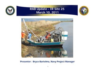
7. Air Boat
The air boat is capable of moving across very shallow water (one inch
deep). Utility locators, surveyors, and sediment samplers were shuttled to
each location to complete the pre-design fieldwork .
hl ti t l t th d i fi ld k
7
8. Air Boat Sample Collection
Twenty-eight (28) sediment samples were collected for chemical (PCBs,
pesticides, lead and zinc) analysis (hand auger sample on left) and
eighteen (18) sediment samples were collected for geotechnical analysis
(undisturbed tube on right) to refine the remedial design.
8
11. Treatability Study
• In addition to the chemical and geotechnical samples, five (5) bulk soil
samples were sent to a laboratory for a treatability study. Results of
p y y y
the study will be provided in the Pre-Design Completion Report and will
recommend a reagent suitable to stabilize metals in soil.
• Testing three (3) reagents:
g ( ) g
– Terra-Bond™
– EnviroBlend®
– ECOBOND®
• What does this all mean? If
concentrations of lead in soil are
g
greater than or equal to 100
q
mg/kg, that soil will be segregated
into a separate stockpile for
additional lab analysis and
possible mixing with a stabilizing
agent before disposal.
11
12. Site 25 Remedial Action Areas
(
(Before Pre-Design Sampling)
Pre- g p g)
12
13. Site 25 Remedial Action Areas
(
(After Pre-Design Sampling)
Pre- g p g)
• Pre-design sampling Removed
resulted in a >3 acre Added
Polygon
reduction in the overall Polygon
areas requiring remedial
action (total = 31.9 acres)
• Sample results will be
presented in a Completion
Report and will also be
incorporated into a
Remedial Design/Remedial
Action Work Plan
(RD/RAWP)
• The RD/RAWP will detail
the excavation of sediment
from areas above the
remedial action objective,
with field activities
commencing in
Summer/Fall 2011
13
14. Remedial Action Challenges
• Rainfall/Discharge
• Heavy Equipment Access
• Recently Opened Portion of the Bay Trail
• Special Species
• Vegetation R
V t ti Removal l
14