SATAID is a software that visualizes meteorological data in multiple dimensions to assist forecasters. It allows users to:
1. Display satellite images, numerical weather prediction data, and observation data from various sources.
2. Control the animation of satellite images and measure features like brightness, movement vectors, time series, cross sections, and histograms.
3. Customize the display by adjusting color scales, drawing on images, and changing window sizes.


![Zoom in/out
12RSMC Tokyo – Typhoon Center
Here
Method 1
- Display enlarged area
Click [Zoom] button and drag area
- Back to whole image
Click [Normal] button
You can digitally designate area with longitude/latitude information
“ “ + “ ” + [Zoom]
Tips
Method 2
- Zoom in : “ “ + “ ” + “ Left-Click”
- Zoom out : “ “ + “ ” + “ Right-Click”Ctrl Shift
Ctrl Shift
Ctrl Shift](https://image.slidesharecdn.com/quick-guidesataidforwis-150707021921-lva1-app6891/85/Quick-guide-sataid-for-wis-12-320.jpg)
![Display coast/grid line
RSMC Tokyo – Typhoon Center 13
Here
Select intervals of
latitude/longitude
you can select [Map element] in the [Option]
menu to add rivers/lakes/frontier etc.
Check with [Ctrl] key: larger fonts
Check with [Shift] key: with background
You can change colors of these lines by selecting
[Line color] in the [Option] menu](https://image.slidesharecdn.com/quick-guidesataidforwis-150707021921-lva1-app6891/85/Quick-guide-sataid-for-wis-13-320.jpg)


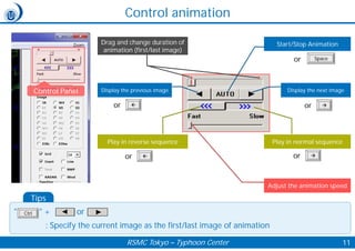
![Change elements
RSMC Tokyo – Typhoon Center 16
1. Click upper-left corner of the window
-> Pop up the menu
2. You can change elements in the panel
• When the [Data file] is clicked, CSV file of selected NWP elements is output.
• When the [Last init.] is NOT selected, the earliest initial NWP data is displayed.
• When the [Interpolation] is selected, forecast fields between forecast time can be interpolated and displayed (i.e. if
Interpolation is NOT selected, NWP data is shown only every 6 hours).
Tips](https://image.slidesharecdn.com/quick-guidesataidforwis-150707021921-lva1-app6891/85/Quick-guide-sataid-for-wis-16-320.jpg)


![Change window size
RSMC Tokyo - Tokyo Typhoon Center 37
You can open “The screen size” window to change the size of the SATAID
window by clicking on [Screen size] in the [Option] menu.
The window size is automatically
adjusted to fit your display.
You can adjust the window size
with the width and height (pixel)](https://image.slidesharecdn.com/quick-guidesataidforwis-150707021921-lva1-app6891/85/Quick-guide-sataid-for-wis-37-320.jpg)
![Drawings
RSMC Tokyo – Typhoon Center 38
1. Check “Draw”
Freehand drawing
Select width of line
* Deselect the [curve] checkbox
Spline drawing
• Select width of line and the
[Curve] checkbox
• Click on two or more points on
the displayed image and double-
click on the end point
Partial erasing
• Select the [Erase] checkbox
• Click a line or a character string, etc. in
the current image to erase. Then, it will
be displayed in a reversal color, and it
will be erased if it clicks again.
* When neither [Curve] nor [Erase] is selected, freehand draiwing is available.
Tips](https://image.slidesharecdn.com/quick-guidesataidforwis-150707021921-lva1-app6891/85/Quick-guide-sataid-for-wis-38-320.jpg)
![Drawings
RSMC Tokyo – Typhoon Center 39
1. Check “Draw”
2. Click “Extra”
1. Delete all drawings ([Clear] button)
2. Cancel the previous drawing operation ([Undo] button)
3. Draw lines and arrows (fronts, troughs, or ridges), which can
be drawn in the same way as spline drawings.
*You can click the [Sn-front] button while holding down the
[Ctrl] key to draw a stationary front in red and blue.
4. Draw polygons, closed curves, or cloud rims, which can be
drawn in the same way as spline drawings. These figures can
be changed the color and filled with a hatched pattern.
5. Draw ellipses, circles, or flex oval. You can change the color
and fill with a hatched pattern.
6. Paste cloud form symbols or vortex center symbols (Drag a
symbol to a point where it is to be pasted. The symbol size
can be changed and the symbol can be reversed left to right
by dropping the symbol with pressing the [Ctrl] key)
7. Paste character strings (Drag [Char] to a point where it is to
be pasted. The character size can be changed)
8. Paste wind barbs (Drag [Char] to a point where it is to be
pasted after inputting "WIND ddd(direction in 360
deg.),fff(velocity)". The wind barb size can be changed)
1
2
3
4 5
6
A
B
A: Change color and
hatch pattern
B: Change symbol size](https://image.slidesharecdn.com/quick-guidesataidforwis-150707021921-lva1-app6891/85/Quick-guide-sataid-for-wis-39-320.jpg)


