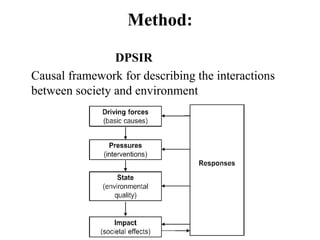
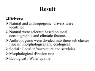
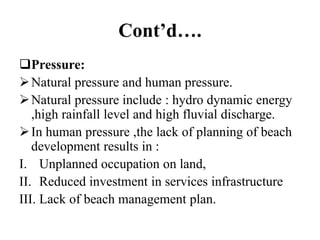
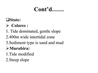
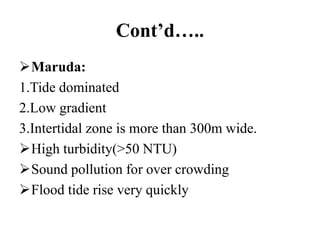
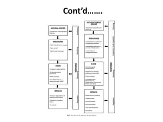
Welcome to
my
Presentation
Presented by
Eti Khan Mitu(17 CDM 019)
Contents
1.Introduction
a)Study area
I. Description
II. Map
b)Causes for selecting this area
2.Method
3.Result
I. Driver
II. Pressure
III. State
IV. Impact
V. Response
4.Conclusion
Introduction
Amazon forest is one of the largest coastal belt of
mangrove forest than anywhere in the world.
On the Amazon coast ,sandy estuarine beaches
are important for recreational and touristic
activities.
These beaches is located in inlets along a number
of kilometers of coastline.
Majority of these beaches are rural or semi urban
and include both natural landscape and areas that
have been occupied without adequate planning.
Cont’d
Study area
Description:
 Coast of Para: From 350 km inside the
mouth of the Amazon river to Gurupi Bay.
Linear distance is about 650 km.
 Murubira and Colares:Located on the
eastern margin of Marajo Bay and
 Maruda :Maruda beach on the Atlantic
coast.
Cont’d….
This all coast or beaches are influenced by
tidal effects ,flood ,geological structure , high
water energy , turbidity etc.
Intertidal zone is used for recreational
activities.
Recreational use is limited during high tide .
During peak vacation period ,temporary
services are installed on the semi urban beach.
Map
Causes for selecting this area
Causes of selection are :
It is one of the largest coastal belt of mangrove forest
than anywhere in the world.
This place is suitable for applying DPSIR framework.
Combination of natural processes and human pressure.
For knowing the environmental condition.
For knowing the systematic management .
For analysing the environmental and social problem.
For evaluating the changes of natural forces and human
use.
Method:
DPSIR
Causal framework for describing the interactions
between society and environment
Result
Drivers:
Natural and anthropogenic drivers were
identified.
Natural were selected based on local
oceanographic and climatic feature.
Anthropogenic were divided into three sub classes
: social ,morphological and ecological.
Social : Local infrastructure and servicies
Morphological :Erosion rate
Ecological : Water quality
Cont’d….
Pressure:
Natural pressure and human pressure.
Natural pressure include : hydro dynamic energy
,high rainfall level and high fluvial discharge.
In human pressure ,the lack of planning of beach
development results in :
I. Unplanned occupation on land,
II. Reduced investment in services infrastructure
III. Lack of beach management plan.
Cont’d……
State:
 Colares :
1. Tide dominated, gentle slope
2.400m wide intertidal zone
3.Sediment type is sand and mud
Murubira:
1.Tide modified
2.Steep slope
Cont’d…..
Maruda:
1.Tide dominated
2.Low gradient
3.Intertidal zone is more than 300m wide.
High turbidity(>50 NTU)
Sound pollution for over crowding
Flood tide rise very quickly
Cont’d….
Impact : The principle impact during peak
vacation period were:
Erosion : Reduction of beach profile,damage of
infrastructure etc.
Hydrodynamics :Creating potential accidents (
drowning ) and transportation of debris.
Water quality : Pollution through the discharge
of waste water.
Beach use : Lack of planning of recreational
activities .
Cont’d….
Cont’d…..
 Response:
 Despite the ongoing increase in pressure and
environmental Impact ,no evidence was found of
any practical response on the part of local
authorities.
 Assuming progressive population growth and
increasing impacts from beach development and
recreational activities ,it is essential that the local
authorities implement effective management
programme.
Cont’d…….
Conclusion
As no response was detected from from any local
authority ,the finding from this study is
recommend the following mitigation measure:
Development and planning recreational activities
Environmental monitoring
Removal of sewage outfalls
Construction of sewage treatment plant
Increase the public services
Regulation of sound pollution
Thank you

Presentation on dpsir

  • 1.
  • 2.
    Presented by Eti KhanMitu(17 CDM 019)
  • 3.
    Contents 1.Introduction a)Study area I. Description II.Map b)Causes for selecting this area 2.Method 3.Result I. Driver II. Pressure III. State IV. Impact V. Response 4.Conclusion
  • 4.
    Introduction Amazon forest isone of the largest coastal belt of mangrove forest than anywhere in the world. On the Amazon coast ,sandy estuarine beaches are important for recreational and touristic activities. These beaches is located in inlets along a number of kilometers of coastline. Majority of these beaches are rural or semi urban and include both natural landscape and areas that have been occupied without adequate planning.
  • 5.
    Cont’d Study area Description:  Coastof Para: From 350 km inside the mouth of the Amazon river to Gurupi Bay. Linear distance is about 650 km.  Murubira and Colares:Located on the eastern margin of Marajo Bay and  Maruda :Maruda beach on the Atlantic coast.
  • 6.
    Cont’d…. This all coastor beaches are influenced by tidal effects ,flood ,geological structure , high water energy , turbidity etc. Intertidal zone is used for recreational activities. Recreational use is limited during high tide . During peak vacation period ,temporary services are installed on the semi urban beach.
  • 7.
  • 8.
    Causes for selectingthis area Causes of selection are : It is one of the largest coastal belt of mangrove forest than anywhere in the world. This place is suitable for applying DPSIR framework. Combination of natural processes and human pressure. For knowing the environmental condition. For knowing the systematic management . For analysing the environmental and social problem. For evaluating the changes of natural forces and human use.
  • 9.
    Method: DPSIR Causal framework fordescribing the interactions between society and environment
  • 10.
    Result Drivers: Natural and anthropogenicdrivers were identified. Natural were selected based on local oceanographic and climatic feature. Anthropogenic were divided into three sub classes : social ,morphological and ecological. Social : Local infrastructure and servicies Morphological :Erosion rate Ecological : Water quality
  • 11.
    Cont’d…. Pressure: Natural pressure andhuman pressure. Natural pressure include : hydro dynamic energy ,high rainfall level and high fluvial discharge. In human pressure ,the lack of planning of beach development results in : I. Unplanned occupation on land, II. Reduced investment in services infrastructure III. Lack of beach management plan.
  • 12.
    Cont’d…… State:  Colares : 1.Tide dominated, gentle slope 2.400m wide intertidal zone 3.Sediment type is sand and mud Murubira: 1.Tide modified 2.Steep slope
  • 13.
    Cont’d….. Maruda: 1.Tide dominated 2.Low gradient 3.Intertidalzone is more than 300m wide. High turbidity(>50 NTU) Sound pollution for over crowding Flood tide rise very quickly
  • 14.
    Cont’d…. Impact : Theprinciple impact during peak vacation period were: Erosion : Reduction of beach profile,damage of infrastructure etc. Hydrodynamics :Creating potential accidents ( drowning ) and transportation of debris. Water quality : Pollution through the discharge of waste water. Beach use : Lack of planning of recreational activities .
  • 15.
  • 16.
    Cont’d…..  Response:  Despitethe ongoing increase in pressure and environmental Impact ,no evidence was found of any practical response on the part of local authorities.  Assuming progressive population growth and increasing impacts from beach development and recreational activities ,it is essential that the local authorities implement effective management programme.
  • 17.
  • 18.
    Conclusion As no responsewas detected from from any local authority ,the finding from this study is recommend the following mitigation measure: Development and planning recreational activities Environmental monitoring Removal of sewage outfalls Construction of sewage treatment plant Increase the public services Regulation of sound pollution
  • 19.