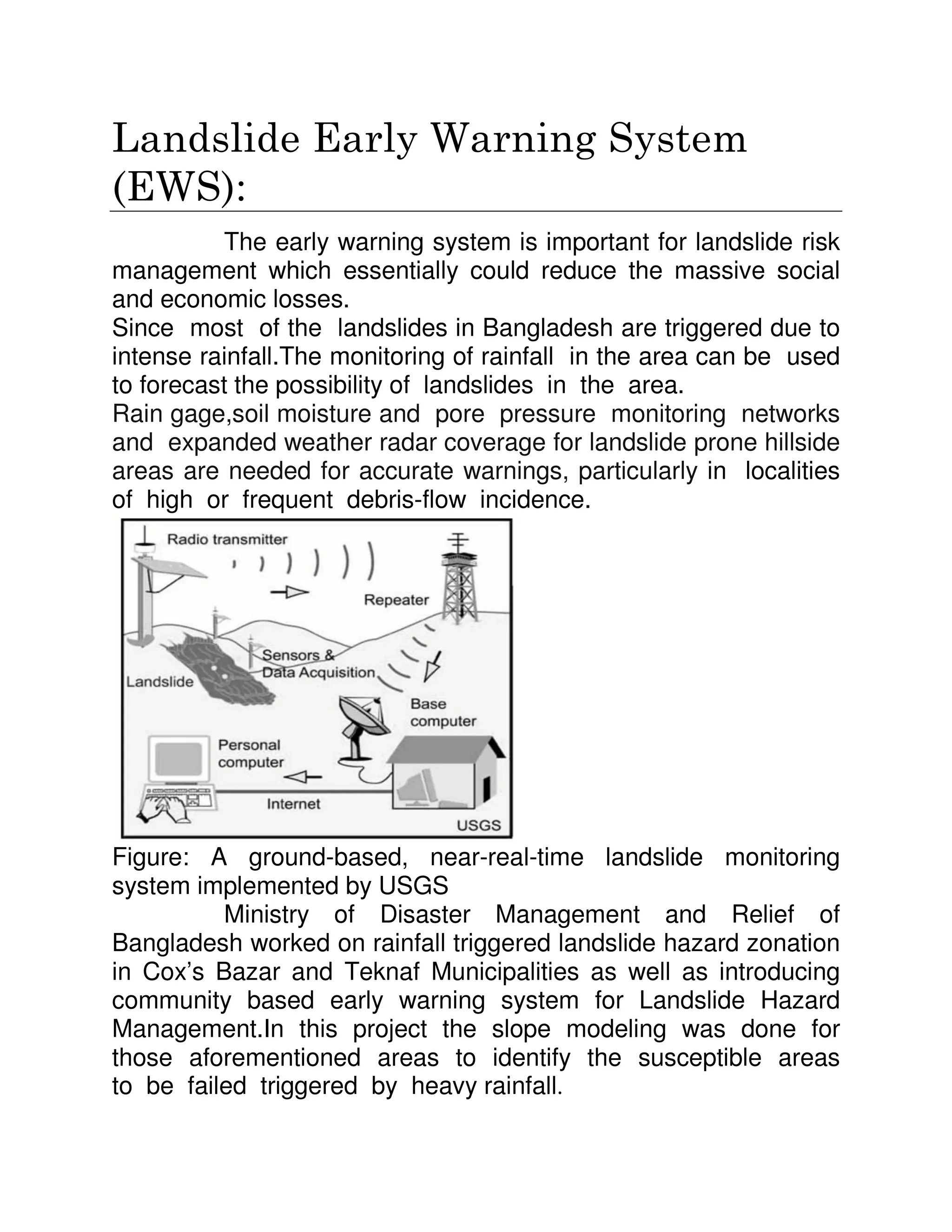
Landslides frequently occur in Bangladesh, especially during the monsoon season. They are triggered by heavy rainfall and made more likely by human activities like deforestation and uncontrolled construction. Three areas that experience many landslides are the Chittagong hills, Chittagong Hill Tracts, and Cox's Bazar coastal region. Landslides destroy property and infrastructure, cause loss of life, and have significant economic and environmental impacts. Both structural measures like retaining walls and non-structural approaches such as land use planning, relocating settlements, and early warning systems are needed to reduce landslide risk in Bangladesh.
Prepared By
Md. Arifuzzaman Arif
MSc in Disaster Management
Department of Geography and Environment
University of Dhaka
BSc in Forestry & Wood Technology Discipline
Khulna University
Running water and streams are formed from net precipitation. Streams are classified as perennial or intermittent depending on continuous flow. A river is a large natural channel that flows into another body of water. Streams have sources, mouths, confluences and basins. Rivers originate based on factors like water availability and slope. They evolve through youthful, mature and old stages. Rivers erode the land through processes like hydraulic action and transport sediment in solution, suspension, saltation and traction. This forms erosional landforms like valleys, gorges, waterfalls and meanders as well as depositional landforms like floodplains, deltas and alluvial fans.
The document discusses the impacts of climate change on Bangladesh's coastal zone. It notes that 20% of Bangladesh's land and 30% of its cultivable land is located in coastal zones, which are home to 35 million people. Climate change is increasing the frequency and intensity of cyclones, floods, erosion, and salinity intrusion. The government has implemented policies like coastal zone management plans and funding mechanisms to build infrastructure and resilience. However, challenges remain around declining ecosystems, pollution, and adapting to issues like sea level rise and changing rainfall patterns.
King's geomorphic model is based on the evolution of idealized hill slopes through four stages - waxing slope, free face, debris slope, and waning slope or pediment. The model involves the parallel retreat of scarps and formation of pediments, resulting in the development of a pediplain landscape over multiple cycles of scarp retreat and pedimentation. Each cycle progresses through youth, mature, and old stages similar to Davis' cycle of erosion. The model was developed based on King's extensive study of landscapes in South Africa.
Riverbank erosion is a major natural hazard in Bangladesh that affects millions of people annually. The erosion destroys farmland, homes, and infrastructure as the major rivers like the Jamuna, Ganges, and Padma migrate and change course. Specific areas along these rivers experience erosion rates of up to 1,600 meters per year. The erosion displaces many families and has significant socioeconomic impacts, including loss of livelihoods, debt, unemployment, and the creation of impoverished refugee populations. Whole communities are sometimes forced to relocate multiple times due to the unpredictable shifting of the river channels.
This document discusses river bank erosion in Bangladesh. It notes that Bangladesh has over 250 rivers that are prone to bank erosion during monsoons due to high water flows. The primary causes of erosion are the flat landscape offering little resistance to water forces, rivers entering mature stages where they meander and change course frequently, and large sediment loads that cause flooding and erosion. Erosion negatively impacts communities through loss of land and housing, economic impacts from lost agriculture land, and health impacts. The document outlines measures to reduce erosion including hard structures, increasing flow areas, planting vegetation, and using wood pilings.
Fluvial Morphology handbook for students.
Contents are: definition, scope, importance of Fluvial Morphology, sediment load, channel pattern and process, role sediment to build delta, Reynolds number, Froude Number, channel pattern of Tista and Jamuna River, causes and consequences of flood, benefit of flood, flood and floodplain, hydraulic geometry, water resource management (in Bangladesh), hydrograph, origin and development of river, tributary and distributary and many more.
River Bank Erosion, Risk Assessment and Communication planning fot communitti...Tusliha
This document summarizes a presentation on river bank erosion in Bangladesh. It discusses how river bank erosion is a major ongoing disaster in Bangladesh that affects millions of people each year. Key points made include: (1) River bank erosion is caused by the dynamic nature of Bangladesh's many rivers and results in loss of land and displacement of communities; (2) Important risk factors like water flow and levels, sedimentation, and rainfall are assessed to understand erosion risks; (3) Communication plans are needed to raise awareness of risks and prepare communities for future erosion events. Management relies on both structural measures and policies to support vulnerable groups affected by erosion.
Natural Hazard is a common phenomena of Bangladesh which makes visit here every year. It contains a detail study about the natural hazards of Bangladesh with its seasonal distribution, causes, effects and necessary maps. An extended Hazard Calendar has been added here.
Presented by Jaap de Heer
Revitalizing the Ganges Coastal Zone Conference
21-23 October 2014, Dhaka, Bangladesh
http://waterandfood.org/ganges-conference/
This document defines and classifies different types of landslides. It discusses landslides as earth movements that can be earth flows, debris slides, rock falls, etc. depending on speed and material. The document outlines various causes of landslides including weathering, erosion, earthquakes, construction and explains signs of landslide occurrence. Prevention methods are discussed including drainage control, vegetation planting, and engineering structures.
Landforms of bangladesh and their relation to natural hazardsJahangir Alam
Landforms of Bangladesh and their Relation to natural hazards:
Bangladesh is situated between 23 34’ and 26 38’ North latitude and 88 01’ and 92 41’East longitude.
The topography is flat with elevation not exceeding 10 meters above mean sea level.
Floodplain and piedmont plains occupy almost 80 percent of the land area.
It is a low-lying, riverine country located in South Asia with a largely marshy jungle coastline of 580 km (360 mi) on the northern littoral of the Bay of Bengal.
Bangladesh has a tropical monsoon climate characterized by heavy seasonal rainfall, high temperatures, and high humidity.
To know about the land forms of Bangladesh.
To know about the hazards of Bangladesh.
To find out the relationship between landforms and Hazards.
Topography is a configuration of a land surface including it’s relief and contours, the distribution of mountains and valleys , the patterns of rivers and other natural features that produce the landscape .
There are three distinctive natural features in Bangladesh.
A broad alluvial plain subject to frequent flooding.
A slightly elevated relatively older plain
A small hill region drained by fant flowing rivers.
Coastal Geomorphology Landforms Of Wave Erosion & DepositionPRasad PK
This document discusses various coastal landforms and processes. It defines coastal geomorphology and describes how waves, longshore currents, rip currents, and tides shape coastal areas and transport sediment. It then lists and describes specific coastal landforms like headlands, bays, sea cliffs, beaches, bars, spits, tombolos, sand dunes, salt marshes, and more. For each landform, it provides a brief definition and example photo. Coastal erosion processes like abrasion, hydraulic action, corrosion, and attrition are also outlined.
Landslides Represent Permanent Deformation Caused By The Downward And Outward Movements Of Large Volumes Of Soil And/Or Rock Under The Influence Of Gravity. Landslides Occur Naturally. Landslides Can Be Triggered And/Or Exacerbated By: 1) Water (From Precipitation During A Tropical Storm, Hurricane, Or Typhoon), Or 2) Vibrations (From Ground Shaking) During An Earthquake. Millions Of Communities Are Not Resilient To Landslide Disasters. One Of The Myths Of Disasters Is That Landslide Disasters, Which Occur Annually In Every Nation, Should Be Enough To Make All Nations Adopt And Implement Policies That Will Lead To Landslide Disaster Resilience. But The Fact Of The Matter Is, This Premise Is Wrong; It Usually Takes Multiple Disasters Before A Stricken Nation Will Adopt Policies To Move Towards Disaster Resilience. Lesson: The Timing Of Anticipatory Actions Is Vital. The People Who Know: 1) What To Expect (E.G., Rock Falls, “quake Lakes,” Mud Flows, Etc.), 2) Where And When It Will Happen, And 3) What They Should (And Should Not) Do To Prepare Will Survive. The People Who Have Timely Early Warning In Conjunction With A Modern Monitoring System, And A Community Evacuation Plan That Facilitates Getting Out Of Harm’s Way From The Risks Associated With Rock Falls, Mudflows, Etc. Will Survive. Engineering To Stabilize Slopes Will Reduce Damage To Buildings And Infrastructure And Help Sustain Their Functions And Save Lives. Presentation courtesy of Dr. Walter Hays, Global Alliance For Disaster Reduction
River erosion is a major threat in Bangladesh, affecting about 1 million people annually and causing $500 million in economic losses. The country's major rivers, including the Brahmaputra and Jamuna, have shifted channels and eroded riverbanks at rates up to 784 meters per year. This has destroyed farmland, infrastructure, and communities. One family profiled lost their 20 acres of land and livelihood to erosion by the Brahmaputra river, forcing the father to become a day laborer. The government has implemented two projects to mitigate erosion impacts and help the millions of Bangladeshis suffering from land loss and poverty due to the country's shifting rivers.
This document summarizes landslides, including common causes, types, effects, and mitigation strategies. It discusses how landslides occur due to gravity when forces acting downslope exceed the strength of earth materials. Common triggers include rainfall, erosion, earthquakes, and human activity. Major landslide types include falls, slides, topples, spreads, and flows. The document then summarizes specific landslides that occurred in Kerala in 2018 due to heavy rainfall, killing 19 people. It concludes with recommended mitigation approaches such as land assessment, slope stabilization, vegetation planting, and revising building rules to restrict development in hazardous areas.
The document discusses flooding in Bangladesh. It describes how Bangladesh experiences regular flooding due to its location at the confluence of three major rivers and its low-lying delta. Flooding causes widespread damage but also replenishes soils. Proposed solutions like embankments have had limited success due to high costs and environmental impacts. A mixture of strategies like forecasting, shelters, and eco-friendly projects may better help Bangladesh adapt.
This document provides an overview of flooding in Bangladesh. It discusses the major river systems in Bangladesh and defines different types of floods. It then summarizes the causes of flooding in Bangladesh, which include its low topography, high monsoon flows, siltation of rivers, and effects of tides. Impacts of flooding are extensive and include loss of lives, crops, infrastructure, and economic losses. Several major floods are described, including the devastating 1988 flood that affected over 60% of the country. In summary, Bangladesh's geographic features and location make it highly vulnerable to flooding.
A landslide is a type of mass movement where part of a slope fails and collapses downhill, carrying materials such as soil, trees, rocks, and buildings. Landslides can be caused by natural factors like heavy rain weakening the soil and slope, or by human activities like deforestation. They can cause severe damage through loss of life, destroyed structures, and devastated communities. When a landslide occurs, it is important to quickly alert others and evacuate the area as safety as possible in order to avoid injury. A tragic example is the 1963 landslide in Italy into the Vajont Dam reservoir, which caused a 250 meter wave that destroyed towns and killed over 2,000 people.
Deltas- types, formation, case studiesNishay Patel
Deltas are landforms formed at river mouths where sediment is deposited as the river enters a sea or lake. They are fan-shaped areas that can span hundreds of kilometers. The Indus River Delta in Pakistan covers 40,000 square kilometers and has a complex network of distributaries. Deltas form as rivers slow down at their mouths, causing sediment to flocculate and settle, building up over time. Different types of deltas include bird's foot, arcuate, and cuspate shapes, depending on factors like tidal influence. Deltas provide fertile land and resources but are also at high risk of flooding and channel migration due to their unstable sediments.
River bank erosion, its migration, causesNazim Naeem
Riverbank Erosion is an endemic natural hazard in our country.
When rivers enter the mature, they become sluggish and
meander or braid. These oscillations cause extreme riverbank
erosion. It is a perennial problem in our country.
• It has been estimated that tens of thousands of people are
displaced annually by river erosion in Bangladesh, possibly up to
100,000. Many households are forced to move away from their
homesteads due to riverbank erosion and flood.
• As per different sources, 500 kilometres of riverbank face
severe problems related to erosion. The northwest part of the
country is particularly prone to riverbank erosion, which has
turned the region into an economically depressed area.
Applied geomorphology examines how landforms and geological processes impact society and how human activities affect landforms. It provides solutions to issues like coastal erosion, landslides, and river management. Applied geomorphologists create maps, models, and predictions to help scientists, engineers, and decision-makers address hazards, land use, natural resources, and environmental changes. They also advise on public policy regarding human-landform interactions.
The document discusses landslide disaster management. It defines landslides and their causes such as changes in slope, load, water content, etc. It identifies landslide hazard areas as those with slopes over 15%, a history of landslides, or erosion. The document outlines the disaster management cycle and approaches to both pre-disaster studies like hazard mapping and post-disaster studies such as damage assessments and stabilization efforts. It recommends various risk reduction measures for land use planning, infrastructure development, and stabilization.
Flooding regularly occurs in Bangladesh due to several factors:
1) Bangladesh has a low-lying delta region with 70% of land under 1m above sea level, making it prone to flooding from rivers and monsoon rains.
2) Heavy monsoon rains from May to October cause rivers like the Ganges and Brahmaputra to overflow their banks.
3) Melting snow from the Himalayas in spring adds additional water to rivers flowing through Bangladesh.
Hydraulic geometry describes how a river's characteristics change with discharge both at a single cross section (at-a-station) and longitudinally along the channel (downstream). Key characteristics measured include depth, width, velocity, suspended sediment load, and slope. These parameters can be expressed as power functions of discharge and often follow similar patterns between rivers despite different settings. Hydraulic geometry was introduced by Leopold and Maddock to quantify these variations in channel geometry with flow.
Landslides in the Hilly Regions of Bangladesh and Mitigation Measures Anjalina Diana Podder
Just a concept on the Landslide situation in Chittagong Hill Tracts of Bangladesh. This is University Presentation for Group 3, Batch 11, MSc in Disaster Management, University of Dhaka
The term landslide or less frequently, landslip, refers to several forms of mass wasting that include a wide range of ground movements, such as rockfalls, deep-seated slope failure
A landslide is the movement of rock, earth, or debris down a sloped section of land. Landslides are caused by rain, earthquakes, volcanoes, or other factors that make the slope unstable. s, mudflows and debris flows
Natural and Anthropogenic Impacts on SedimentationAnonymousNetizen
The document summarizes natural and anthropogenic impacts on sediment accumulation processes in arid environments. Natural impacts include tectonics, climate, and storminess which control sediment production, transport, and deposition over long and short timescales. Anthropogenic impacts include water resource development leading to salinization, soil erosion, mineral extraction, aeolian and water hazards, and salt accumulation. Human activities can exacerbate natural geologic and climatic processes to alter sediment dynamics in arid regions.
Rotational and translational slides, rock falls, rock toppling, lateral spreading, and debris flows are the main types of landslides. Landslides are caused by both natural factors like heavy rainfall, earthquakes, and steep slopes, as well as human factors like inappropriate drainage and slope cutting. The 1998 Malpa landslide in Uttarakhand, India killed over 200 people after heavy rains caused a massive rock fall. Proper land use planning, drainage, afforestation, and early warning systems can help reduce landslide risks.
The document discusses land resources and degradation issues in India. It notes that land area makes up 1/5 of the Earth's surface and efficient land management will be critical to meet food, fiber and fuel demands. Major land degradation problems include soil erosion, salinity, waterlogging, and shifting cultivation. Causes of degradation include deforestation, overgrazing, agriculture practices like over-irrigation, and industrialization. Specific issues discussed in detail include soil erosion, salinization, landslides, waterlogging, desertification, and shifting cultivation. The role of individuals in conserving natural resources like water is also highlighted.
This document discusses land as an important natural resource and various causes of land degradation. It notes that humanity's development has damaged land resources through issues like soil erosion, deforestation, overgrazing, and excessive population growth. Specific causes of soil erosion discussed include water erosion processes like sheet, rill, and gully erosion, as well as wind erosion processes like saltation, suspension, and surface creep. Other issues covered include landslides, desertification, and water logging and salinity issues caused by excessive irrigation. The document emphasizes the importance of sustainable land management given India's large population and need for food security.
Erosion is the process by which soil and rock are removed from the Earth's surface by natural forces like wind and water. While erosion is natural, human activities have increased erosion rates globally by 10-40 times, causing problems like land degradation. The main types of erosion are water erosion from rainfall, rivers, coastal areas, glaciers and floods; wind erosion; and gravitational erosion.
Sanskriti Kumari presented on the topic of soil erosion and its causes. She discussed the different types of soil erosion including water erosion, wind erosion, and mass movement. Water erosion can occur through splash erosion, sheet erosion, rill erosion, gully erosion, ravine erosion, and more. Wind erosion moves soil particles through surface creep, saltation, and suspension. Mass movement includes processes like creep, landslides, debris flows, and mudflows. The causes of soil erosion include soil erodibility, slope, climate, rainfall, deforestation, farming practices, and more. Long-term soil erosion degrades soil fertility and productivity by reducing topsoil thickness, rooting depth, and soil nutrient levels.
Due to the large-scale exploitation of mineral resources and the unreasonable human activities, the
geological disasters in Jiaozuo City have become increasingly prominent and the degree of harm increased. This
leds to a tremendous threat to human life and property safety. Jiaozuo City, the main types of geological
disasters, landslides, ground subsidence, debris flow and ground fissures. It has great significance to the
development of the city and the protection of people's life and property to explore the hidden dangers of
geological disasters and actively take preventive and control measures. The establishment of geological
hazard group measurement system of prevention and control to achieve the timely detection of geological
disasters, rapid early warning and effective avoidance.
Erosion refers to detachment and transport of soil and soil materials by water, wind, ice or gravity.
No soil phenomenon is more destructive worldwide than the erosion caused by wind and water. Erosion damages the site on which it occurs and also has undesirable effects off-site in the larger environment.
Soil & water conservation.pptx for agricultural departmentsharanjain0
Soil erosion is the removal and transportation of soil from its original location by water, wind, or other forces. There are two main types of soil erosion: geological erosion which occurs naturally under vegetation cover; and accelerated erosion which occurs at a much faster rate when vegetation is removed and land is cultivated. Factors like deforestation, overgrazing, and poor agricultural practices can lead to accelerated water and wind erosion. Water erosion specifically occurs through raindrop splash, sheet wash, rill formation, gullying, and stream/river bank erosion. The universal soil loss equation is commonly used to estimate average annual soil loss. Unchecked erosion has negative environmental and economic impacts through loss of fertile topsoil and siltation of
This document provides information about landslides including their definition, causes, types, impacts, examples in Bangladesh, risk assessment, and prevention methods. It defines landslides as the downward and outward movement of slope-forming materials like rock, soil, and debris. The key causes are geological factors, morphological factors, physical factors, and human activity. Landslides are classified based on their movement type (falling, sliding, flowing) and material (rock, soil). Their global impacts include loss of life and infrastructure damage. Examples in Bangladesh and a chronology of major landslides are also provided, along with methods to minimize landslide risk and effects.
Soil erosion-History, distribution, identification, forms, impact of soil ero...Annappa N N
The document discusses the history and distribution of soil erosion globally and in India. It describes common forms of soil erosion such as water erosion, wind erosion, and mass movement. Key indicators for identifying soil erosion are mentioned, such as eroded soil, gullies, sedimentation, and loss of topsoil. The impacts of soil erosion include reduced soil fertility, increased flooding, and water pollution. Strategies to control erosion include terracing, contour plowing, cover cropping, check dams, and reforestation.
Bangladesh , the largest delta on earth, is situated
in South Asia. It is located between 20°
34′ and
26°
38′ north latitude and 88°
01′ and 92°
41′ east
longitude. It is bordered by India on the west,
north, and east, by Myanmar on the southeast, and
by the Bay of Bengal on the south. The area of the
country is 147,570 km2
. Most of the country is
low-lying comprising mainly the delta of the
Ganges and Brahmaputra rivers. A total of 80% of
the country is floodplain . The environment of the
country is under severe pressure due to changing
climate and destructive anthropogenic activities.
Environmental degradation is directly and
indirectly affecting human health, ecosystems
, and economic growth of the country. Demographic pressure, poverty,lack of proper
awareness on environmental issues, and lack of implementation and monitoring of
environmental rules are the main causes for existing environmental condition of
Bangladesh. The climatic condition of Bangladesh is tropical monsoon. The country
currently faces several environmental issues which threaten these resources, including
groundwater metal contamination, increased groundwater salinity, cyclones and flooding, and
sedimentation and changing patterns of stream flow due to watershed mismanagement. Some
of these, such as the changing patterns of stream flow and presence of lead in groundwater,
can be directly correlated with human activity and industrial processes, while others, such as
cyclones and flooding are naturally occurring issues.
Pingdingshan Coal Mine district is one of the six mining areas of Henan Province, which is a
large coal base in China. After 60 years of exploitation, it has brought great benefits, at the same time,
serious geological disasters have been occurred. It has seriously damaged the normal production of the
masses, life, restricting the development of Pingdingshan coal mine economy. In this paper, the
geological disasters such as ground collapse, ground fissures and ground subsidence in Pingdingshan coal
mine are analyzed, and the degree of geological disasters in the mining area is analyzed in combination
with the severely affected mining area. Finally, reasonable and feasible countermeasures have been put
forward.
This document discusses landslides, their causes, prevention techniques, and environmental impacts. It identifies three main causes of landslides: water, seismic activity, and volcanic activity. Heavy rain can saturate slopes and cause landslides, while earthquakes weaken slopes through ground shaking. Volcanic eruptions can melt snow and ice rapidly, generating destructive debris flows. The document outlines various landslide prevention techniques, including retaining walls, geogrids, expansive anchor bolts, and managing water drainage. It notes that landslides can damage infrastructure and ecosystems, lower property values, and disrupt transportation.
This document contains information about the National Anthem, Pledge and Fundamental Duties of Indian citizens as outlined in the Constitution of India. It then discusses rivers as geological agents of erosion, transportation and deposition. The key erosional landforms created by rivers include pot holes, waterfalls, river valleys, escarpments and terraces. Rivers transport sediment load using kinetic energy. Deposition occurs where the river's transport capacity decreases due to factors like decreasing slope and velocity. Important depositional features include alluvial fans and cones.
Immersive Learning That Works: Research Grounding and Paths ForwardLeonel Morgado
We will metaverse into the essence of immersive learning, into its three dimensions and conceptual models. This approach encompasses elements from teaching methodologies to social involvement, through organizational concerns and technologies. Challenging the perception of learning as knowledge transfer, we introduce a 'Uses, Practices & Strategies' model operationalized by the 'Immersive Learning Brain' and ‘Immersion Cube’ frameworks. This approach offers a comprehensive guide through the intricacies of immersive educational experiences and spotlighting research frontiers, along the immersion dimensions of system, narrative, and agency. Our discourse extends to stakeholders beyond the academic sphere, addressing the interests of technologists, instructional designers, and policymakers. We span various contexts, from formal education to organizational transformation to the new horizon of an AI-pervasive society. This keynote aims to unite the iLRN community in a collaborative journey towards a future where immersive learning research and practice coalesce, paving the way for innovative educational research and practice landscapes.
The debris of the ‘last major merger’ is dynamically youngSérgio Sacani
The Milky Way’s (MW) inner stellar halo contains an [Fe/H]-rich component with highly eccentric orbits, often referred to as the
‘last major merger.’ Hypotheses for the origin of this component include Gaia-Sausage/Enceladus (GSE), where the progenitor
collided with the MW proto-disc 8–11 Gyr ago, and the Virgo Radial Merger (VRM), where the progenitor collided with the
MW disc within the last 3 Gyr. These two scenarios make different predictions about observable structure in local phase space,
because the morphology of debris depends on how long it has had to phase mix. The recently identified phase-space folds in Gaia
DR3 have positive caustic velocities, making them fundamentally different than the phase-mixed chevrons found in simulations
at late times. Roughly 20 per cent of the stars in the prograde local stellar halo are associated with the observed caustics. Based
on a simple phase-mixing model, the observed number of caustics are consistent with a merger that occurred 1–2 Gyr ago.
We also compare the observed phase-space distribution to FIRE-2 Latte simulations of GSE-like mergers, using a quantitative
measurement of phase mixing (2D causticality). The observed local phase-space distribution best matches the simulated data
1–2 Gyr after collision, and certainly not later than 3 Gyr. This is further evidence that the progenitor of the ‘last major merger’
did not collide with the MW proto-disc at early times, as is thought for the GSE, but instead collided with the MW disc within
the last few Gyr, consistent with the body of work surrounding the VRM.
When I was asked to give a companion lecture in support of ‘The Philosophy of Science’ (https://shorturl.at/4pUXz) I decided not to walk through the detail of the many methodologies in order of use. Instead, I chose to employ a long standing, and ongoing, scientific development as an exemplar. And so, I chose the ever evolving story of Thermodynamics as a scientific investigation at its best.
Conducted over a period of >200 years, Thermodynamics R&D, and application, benefitted from the highest levels of professionalism, collaboration, and technical thoroughness. New layers of application, methodology, and practice were made possible by the progressive advance of technology. In turn, this has seen measurement and modelling accuracy continually improved at a micro and macro level.
Perhaps most importantly, Thermodynamics rapidly became a primary tool in the advance of applied science/engineering/technology, spanning micro-tech, to aerospace and cosmology. I can think of no better a story to illustrate the breadth of scientific methodologies and applications at their best.
The cost of acquiring information by natural selectionCarl Bergstrom
This is a short talk that I gave at the Banff International Research Station workshop on Modeling and Theory in Population Biology. The idea is to try to understand how the burden of natural selection relates to the amount of information that selection puts into the genome.
It's based on the first part of this research paper:
The cost of information acquisition by natural selection
Ryan Seamus McGee, Olivia Kosterlitz, Artem Kaznatcheev, Benjamin Kerr, Carl T. Bergstrom
bioRxiv 2022.07.02.498577; doi: https://doi.org/10.1101/2022.07.02.498577
EWOCS-I: The catalog of X-ray sources in Westerlund 1 from the Extended Weste...Sérgio Sacani
Context. With a mass exceeding several 104 M⊙ and a rich and dense population of massive stars, supermassive young star clusters
represent the most massive star-forming environment that is dominated by the feedback from massive stars and gravitational interactions
among stars.
Aims. In this paper we present the Extended Westerlund 1 and 2 Open Clusters Survey (EWOCS) project, which aims to investigate
the influence of the starburst environment on the formation of stars and planets, and on the evolution of both low and high mass stars.
The primary targets of this project are Westerlund 1 and 2, the closest supermassive star clusters to the Sun.
Methods. The project is based primarily on recent observations conducted with the Chandra and JWST observatories. Specifically,
the Chandra survey of Westerlund 1 consists of 36 new ACIS-I observations, nearly co-pointed, for a total exposure time of 1 Msec.
Additionally, we included 8 archival Chandra/ACIS-S observations. This paper presents the resulting catalog of X-ray sources within
and around Westerlund 1. Sources were detected by combining various existing methods, and photon extraction and source validation
were carried out using the ACIS-Extract software.
Results. The EWOCS X-ray catalog comprises 5963 validated sources out of the 9420 initially provided to ACIS-Extract, reaching a
photon flux threshold of approximately 2 × 10⁻⁸ photons cm−2
s
−1
. The X-ray sources exhibit a highly concentrated spatial distribution,
with 1075 sources located within the central 1 arcmin. We have successfully detected X-ray emissions from 126 out of the 166 known
massive stars of the cluster, and we have collected over 71 000 photons from the magnetar CXO J164710.20-455217.
Travis Hills of MN is Making Clean Water Accessible to All Through High Flux ...Travis Hills MN
By harnessing the power of High Flux Vacuum Membrane Distillation, Travis Hills from MN envisions a future where clean and safe drinking water is accessible to all, regardless of geographical location or economic status.
Sexuality - Issues, Attitude and Behaviour - Applied Social Psychology - Psyc...PsychoTech Services
A proprietary approach developed by bringing together the best of learning theories from Psychology, design principles from the world of visualization, and pedagogical methods from over a decade of training experience, that enables you to: Learn better, faster!
Discovery of An Apparent Red, High-Velocity Type Ia Supernova at 𝐳 = 2.9 wi...Sérgio Sacani
We present the JWST discovery of SN 2023adsy, a transient object located in a host galaxy JADES-GS
+
53.13485
−
27.82088
with a host spectroscopic redshift of
2.903
±
0.007
. The transient was identified in deep James Webb Space Telescope (JWST)/NIRCam imaging from the JWST Advanced Deep Extragalactic Survey (JADES) program. Photometric and spectroscopic followup with NIRCam and NIRSpec, respectively, confirm the redshift and yield UV-NIR light-curve, NIR color, and spectroscopic information all consistent with a Type Ia classification. Despite its classification as a likely SN Ia, SN 2023adsy is both fairly red (
�
(
�
−
�
)
∼
0.9
) despite a host galaxy with low-extinction and has a high Ca II velocity (
19
,
000
±
2
,
000
km/s) compared to the general population of SNe Ia. While these characteristics are consistent with some Ca-rich SNe Ia, particularly SN 2016hnk, SN 2023adsy is intrinsically brighter than the low-
�
Ca-rich population. Although such an object is too red for any low-
�
cosmological sample, we apply a fiducial standardization approach to SN 2023adsy and find that the SN 2023adsy luminosity distance measurement is in excellent agreement (
≲
1
�
) with
Λ
CDM. Therefore unlike low-
�
Ca-rich SNe Ia, SN 2023adsy is standardizable and gives no indication that SN Ia standardized luminosities change significantly with redshift. A larger sample of distant SNe Ia is required to determine if SN Ia population characteristics at high-
�
truly diverge from their low-
�
counterparts, and to confirm that standardized luminosities nevertheless remain constant with redshift.
ESA/ACT Science Coffee: Diego Blas - Gravitational wave detection with orbita...Advanced-Concepts-Team
Presentation in the Science Coffee of the Advanced Concepts Team of the European Space Agency on the 07.06.2024.
Speaker: Diego Blas (IFAE/ICREA)
Title: Gravitational wave detection with orbital motion of Moon and artificial
Abstract:
In this talk I will describe some recent ideas to find gravitational waves from supermassive black holes or of primordial origin by studying their secular effect on the orbital motion of the Moon or satellites that are laser ranged.
CLASS 12th CHEMISTRY SOLID STATE ppt (Animated)eitps1506
Description:
Dive into the fascinating realm of solid-state physics with our meticulously crafted online PowerPoint presentation. This immersive educational resource offers a comprehensive exploration of the fundamental concepts, theories, and applications within the realm of solid-state physics.
From crystalline structures to semiconductor devices, this presentation delves into the intricate principles governing the behavior of solids, providing clear explanations and illustrative examples to enhance understanding. Whether you're a student delving into the subject for the first time or a seasoned researcher seeking to deepen your knowledge, our presentation offers valuable insights and in-depth analyses to cater to various levels of expertise.
Key topics covered include:
Crystal Structures: Unravel the mysteries of crystalline arrangements and their significance in determining material properties.
Band Theory: Explore the electronic band structure of solids and understand how it influences their conductive properties.
Semiconductor Physics: Delve into the behavior of semiconductors, including doping, carrier transport, and device applications.
Magnetic Properties: Investigate the magnetic behavior of solids, including ferromagnetism, antiferromagnetism, and ferrimagnetism.
Optical Properties: Examine the interaction of light with solids, including absorption, reflection, and transmission phenomena.
With visually engaging slides, informative content, and interactive elements, our online PowerPoint presentation serves as a valuable resource for students, educators, and enthusiasts alike, facilitating a deeper understanding of the captivating world of solid-state physics. Explore the intricacies of solid-state materials and unlock the secrets behind their remarkable properties with our comprehensive presentation.
1. Landslide in Bangladesh
Landslide:
Landslide is the downward movement of soil, rock and
organic materials under the effects of gravity and also the
landform that results from such movement.It is one of the most
significant natural damaging disasters in hilly environments, which
includes a wide range of ground movements, such as rock falls,
deep failure of slopes and shallow debris flows.Rapid urbanization
and human development activities such as, building and road
construction through deforestation and excavation of hill slopes
have increased landslide in densely populated cities located in
mountainous areas.The cause is often infiltration of water that
makes the swelling soils(clays) more fluid .Landslides are a major
cause of erosion,causing the strongest degradation known,
10,000 tons per sq km in a year.Land use and land cover
changes have been recognized as world’s one of the most
important factors stirring rainfall triggered landslides. Land cover
changes(e.g. urbanization , deforestation ) causes large variations
in hydro- morphological functioning of hill-slopes, affecting rainfall
partitioning infiltration characteristics and runoff production.
Landslides in Bangladesh:
Bangladesh is a low-laying floodplain area of Ganges
delta in South Asia .Geologically it is part of the Bengal Basin
which has been filled by sediments washed down from the
highlands on three sides of it,especially from the Himalayas.
2. Because of the geographical location,Bangladesh experiences
highest amount of monsoon rainfall and annual average rainfall
among the SAARC countries.The whole country has two different
distinctive geographical features with flat land (82%) and hilly
regions (18%) in the North, North-East and South-East part.
According to geological data,hilly region of Bangladesh developed
in tertiary age. Bangladesh is highly vulnerable to different natural
hazards :flood, cyclone, landslides, drought, earthquakes are very
frequent. A significant number of landslide hazard locations exist
in those urban areas that make many communities vulnerable
to slide which may result in severe damages and socioeconomic
losses.The characteristics of soft sedimentary and unconsolidated
rocks in the hilly terrains,soil structure across the hilly area
makes the slope instable as a consequence caused fatal
landslides.Landslides event not only occurred in the south-
eastern part of the country but also hit consecutively in the
north-eastern part with massive damage.The hilly areas of the
southeastern parts have a long history of instability.Although
written records of landslide incidents are very rare, they have been
living there.Every year especially in the rainy season, landslides
take place in both natural and man induced slopes.
Triggering factors and causes:
The main contributing factors for the mass
movement in Bangladesh can be divided into natural and
human induced factors.
Natural factors : steepness of natural slopes,altitude of
bedding , lithology of rock,infiltration of water,tectonic settings,
strength of rock, climatic variation, topographic and
geomorphological conditions etc.
The human intervention : unscientific exploitation of the
Himalaya, deforestation, unplanned construction and settlement,
3. mining and quarrying activities combined with its complex
geological and heavy rainfall makes the slope instable.
The most common triggering factor is prolonged and intense
monsoon rainfall in Bangladesh perspective.
The major causes of landslide in Bangladesh which involves-
1) Removal of lateral support:
a)erosion by rivers,
b) previous slope movements such as slumps that create
new slopes,
c) human modifications of slopes such as cuts , pits and
canals.
2) Increase of load to the slopes:
a)accumulation of rain water
b) increase in vegetation,
c) construction on fill,
d)weight of buildings and other structures,
e)weight of water from leaking pipelines, sewers,
canals, and reservoirs
3) Earthquakes
4) Regional tilting
5) Removal of underlying support:
a) Undercutting by rivers and waves
b) Swelling of clays
6) Anthropogenic activities as jhum cultivation:
Government of Bangladesh has taken many initiatives to
reduce the landslide risk from the vulnerable area.
The mechanism of landslide is occurred by both internal
forces and external factors. When the gravitational force acting on
a slope exceeds its resisting force, slope failure and mass wasting
occurs. The usual type of soil at the hill slope is silty clay. At most
4. areas, the soil consists of different layers of sand and clay/shale.
Shear strength of silty clay type soil is much lower than regular
sand or clay soils. Again, excessive rainfall had saturated the soil
resulting increase of soil mass.
Landslide in Chittagong and
Chittagong Hill Tracts:
Landslide occurred frequently in Chittagong hilly region
due to extreme uninterrupted monsoon rainfall.The devastation
aggravates along with weak structure,unplanned and erratic use
of hills and settlement development.Because of its favorable
geographical location and easy accessibility for regional and
international trade,the city has developed as an important
commercial hub for the country. As a result population density is
increasing and demand of land going up.Thereby people in the
urban area occupied the vacant government and privately-owned
land both legally and illegally and built informal settlement without
following any rules and regulation. The development authorities of
Chittagong have identified 30 risky hills in this city namely
Matijhorna, Lalkhan Bazar, TankirPahar, Batali Hill, GolPahar AK
Khan Pahar high risk of landslides and associated damage.
Chittagong hills are degrading by different anthropogenic stresses
such as, hill cutting for construction, sand and clay mining,
establishment of settlement in foothills, deforestation etc.
Geology of Chittagong Hill Tracts:
The hill areas are underlain by tertiary and quaternary
sediments that have been folded, faulted and uplifted, then deeply
dissected by rivers and stream. These areas consist of
sandstones and shale and also with siltstone which have less
stability. The bedrock and soil structure of these hills are not
stable for which reason these areas are highly prone to landslide.
5. The composition of soil of these hilly regions is complex and the
young rocks have higher contents of easily-weatherable
feldspars. The hill soils are mainly yellowish brown to reddish
brown loams which grade into broken shale or sandstone as well
as mottled sand at a variable depth. The soils are very strongly
acidic. The soil of the hill slope is usually silty clay. The bedding of
the soil formation is almost horizontal. Alternate layer of sand and
very thin film of cementing clay/shale layer Rainwater seeps
through the layers and over the ages reduces the bond between
the sand and clay/shale layers. The region is rich in natural
resources .Recently many foreign companies are conducting
exploration programs for oil and gas in these regions. As a
developing country, well developed communication system is
required to exploit the natural resources. But areas prone to
landslide hazard and causes and factors of landslide were not
considered during construction of these roads. For these,every
year landslides take place along the roads and block
communications. The construction damages of the Mercantile
Marine Academy, Chittagong were caused due to the lateral
spreading movements in the hills formed of Dupi Tila Formatiion.
Three types of landslides and slope failures which are lateral
spreading movement, rotational and translational movements in
the hills formed of Dupi Tila Formation, planar or block movement
in Bokabil Formation and rotational, translational and planar or
block failures in Tipam Formation are responsible for the
erosional hazards of Chittagong city. The landslides of the Jhagar
beel area, Rangamati district is caused due to the huge loads of
the embankment resting on the weak stream fill sediments and
high slide slopes.
The main causes of landslide in this region are:
1. Access rainfall: Highest precipitation during monsoon.
2. Indiscriminate Hill cutting
3. Weak soli structure oh hills
4. Deforestation in the hilly area
6. 5. Abnormal tidal flow
6. High population and urbanization growth
7. Other causes like seismic activity etc.
Landslides in Coastal Region (Cox’s
Bazar):
Landslides of different magnitudes occur along
Bangladesh’s coastal regions. The Cox’s Bazar coastal region is
one of these regions. The different sections of Cox’s Bazar suffer
many landslide problems.
Coastal cliff suffers from weathering and erosion which causes
many shallow failures of the loosely consolidated sandstones.
These are threating buildings and roads in the Bahar Chara
Area.The agricultural land and houses of local villages have been
badly affected by these slides.Houses and prawn culture forms
are affected by slides and incur considerable financial losses .
The lithological formation of different sections of cliff showed that
the cliff materials consisted of loosely consolidated massive
sandstones.
In this region, very steep cliffs are observed. The steeper cliffs
can reach an unstable condition faster than more gentle cliff as
their heights and slope inclinations change by an equal amount.
Tidal influences are also triggered landslides. Thus, coastal
regions are also vulnerable.
7. Impacts of landslide:
Landslide has huge impacts on the human being and
their environment, including-
• effects on people, their homes and possessions,
• farms and livestock,
• Industrial establishments and other structures.
• Block of roads and communication system
• block of drainage connection,
• loss of soil fertility and
• Loss of biodiversity of floral and faunal species and other
resources.
The major impact is related to destruction of human life,
economic loss, environmental problem and loss of
natural scenic beauty.
Landslide vulnerability is an important issue for people living in the
hilly areas. In the recent years, landslide is occurring regularly.
The main mitigation strategies suggested by the authority were
stopping of hill cutting, resettlement of the affected people,
vegetation and development of robust policy.
Possible measures:
The selection of appropriate measures should be based on
assessment of risk, uncertainty, possible consequences,
constructability, environmental impacts and costs. Usually two
types of approaches can be taken for the prevention of the
disaster:
1. structural solutions and
2. Nonstructural measures.
8. • Structural Measures:
Structural measures considering the safety measures,
building codes and better drainage facilities are inevitable for
mitigation of landslide disaster risk. In Bangladesh, retaining wall
is widely used to stabilize slope which is a costly technology.
Therefore, new affordable and sustainable technology should be
explored to stabilize slopes. The below table describes different
types of possible structural measures with their applicability in the
context of Bangladesh.
9. • Non-Structural Measures:
Soft engineering is as much important as structural
solutions.Land use vulnerability assessment and zoning, early
warning system,relocation of the foothill settlements,controlling hill
cutting through proper enforcement of legal provisions,real time
monitoring and early warning etc. measures can be taken for the
mitigation of landslides.Single method is not effective for
preventing landslides.Among the different methods,bio-
engineering with jute geo-textiles, soil nailing and proper drainage
is the most effective solution.With appropriate long rooted
vegetation (e.g. vetiver grass) and proper techniques landslide
occurrences can be effectively controlled.Warning system relating
with rainfall can also be developed so that people themselves will
be beware of probable landslides just knowing the precipitation of
that area.
10. Landslide Early Warning System
(EWS):
The early warning system is important for landslide risk
management which essentially could reduce the massive social
and economic losses.
Since most of the landslides in Bangladesh are triggered due to
intense rainfall.The monitoring of rainfall in the area can be used
to forecast the possibility of landslides in the area.
Rain gage,soil moisture and pore pressure monitoring networks
and expanded weather radar coverage for landslide prone hillside
areas are needed for accurate warnings, particularly in localities
of high or frequent debris-flow incidence.
Figure: A ground-based, near-real-time landslide monitoring
system implemented by USGS
Ministry of Disaster Management and Relief of
Bangladesh worked on rainfall triggered landslide hazard zonation
in Cox’s Bazar and Teknaf Municipalities as well as introducing
community based early warning system for Landslide Hazard
Management.In this project the slope modeling was done for
those aforementioned areas to identify the susceptible areas
to be failed triggered by heavy rainfall.