This document provides instructions for performing 5 spatial queries in QGIS. The queries include: 1) finding road segments that cross rivers in Maharashtra, 2) finding rivers not flowing through Ahmadnagar District, 3) finding public places within Greater Mumbai, 4) finding schools that could be affected by floods within 3 km of rivers, and 5) finding tehsils in Pune containing water bodies. The document describes the data, steps, and observations for completing each query using selection tools, attribute queries, and exporting features.
A. Lab # BSBA BIS245A-7B. Lab 7 of 7 Database Navigation.docxransayo
A. Lab # : BSBA BIS245A-7
B. Lab 7 of 7 : Database Navigation
C. Lab Overview—Scenario / Summary:
TCOs:
8. Given a database application containing forms, queries, and reports, automate tasks and create a menu system which allows for efficient navigation and operation of the database’s functionality.
Scenario:
The purpose of this iLab is to show the student how to create navigation systems for an Access application. Students will create a main navigation form which links to additional navigation forms called Enter Data and View Reports. Additionally, students will create forms to automate printing reports and Closing/Exiting the Database. The Enter Data form allows you to open Customer and City forms automatically. The View Reports form allows the user to automatically open the Customer List and Customers by City reports. The Print Reports form will allow users to automatically print the reports. The Exit Database form allows users to close the database and exit the application entirely.
The navigation forms can provide some measure of security to the database as they may prevent users unfamiliar with Access from accessing database objects directly; they make using Access more intuitive to use, and can prevent new users from inadvertently damaging your database objects.
D. Deliverables:
Upload the modified Lab7_Start.accdb file that you saved as YourName_Lab7.accdb to the
Week 7 iLab Dropbox.
Step
Deliverable
Points
Part A
Develop the Enter Data, View Reports, Print Reports, and Customer
Database Navigation Forms
Part B
Create the Close Database Form and add it to the Main Database
Navigation Form. Set the Database Options.
E. Lab Steps:
Preparation:
· Download the Access starter file from the Week 7 iLab page, and save the file onto “c:\” directory (your local drive)
· Using Citrix for MS Visio and/or MS Access
· If you are using the Citrix remote lab, follow the login instructions located in the iLab area in Course Home.
· You will have to upload the Lab7_Start.accdbfile to your Citrix folder. Follow the instructions located in the iLab area in Course Home.
· Start MS Access.
· If you are using Citrix, click on Microsoft Office Applications folder.
· If you are using Access on a local computer, select Microsoft Office from your Program Menu.
MS Access Switchboards
In the past, users navigated database applications using a menu system based on a hierarchy similar to that illustrated below.
While this is a logical approach, it was not always efficient or user friendly. Access 2013 allows for development of navigation screens facilitating more efficient movement from one function to another within the database. In this iLab you will create navigation forms that allow users to move through the various objects in a simple Access application. The Access application has two forms (Maintain Customers and Maintain City), and two Reports (Customer List and Customer by City). The navigation system accesses these objects using thi.
Previous weeks work has been uploaded as well as any other pieces ne.docxkeilenettie
Previous weeks work has been uploaded as well as any other pieces needed.
Deliverables
All files are located in the subdirectory of the project. The project should function as specified: When you visit the Personnel form page (frmPersonnel.aspx), a record should be saved in the tblUserActivity table with the IP address, form name accessed (frmPersonnel), and the date accessed. When you click the View Activity button, you should see at least one record with this information. When the user goes to the frmPersonnel web form and enters data, the following business rules are to be enforced.
Fields may not be empty or filled with spaces. If any field is empty, turn that field background color to yellow and add to/create an error message to be shown in the error label.
The end date must be greater than the start date. If the end date is less than the start date turn both date fields yellow and add to/create an error message to be shown in the error label.
If all fields validate properly, then the session state items should be set properly and the user should see the frmPersonnelVerified form with all the values displayed. You will also add a new item to frmMain that will take the user to the new frmUserActivity form you added. Add the proper link and a hyperlinked image to allow the user to select this new option. Once you have verified that everything works, save your website, zip up all files, and submit it.
STEP 1: Step Title
1. Open Microsoft Visual Studio.NET.
2. Open the PayrollSystem website by clicking on it in the Recent Projects list, or by pulling down the File menu, selecting Open Website, navigating to the folder where you previously saved the PayrollSystem, and clicking Open.
3. Download the PayrollSystem_DB.accdb file from the Files section and save it on your local computer. (Note: your operating system may lock or block the file. Once you have copied it locally, right click on the file and select Properties and then Unblock if available). Then add it to the PayrollSystem website as follows: In Visual Studio, in the
Solution
Explorer click Website, Add Existing Item, then navigate to the PayrollSystem_DB.accdb file you downloaded, and click the Add button.
Make sure you select file types, which include *.accdb, *.accdb, etc. Otherwise, you will not be able to see the database file to select.
4. Now we need to create a new connection to the PayrollSystem_DB.accdb. To begin, click View Server Explorer.
5. When the Server Explorer toolbox appears, click the Connect to Database button.
6. When the Add Connection dialog appears, click the Change button. In the Change Data Source dialog, select MS Access Database File; Uncheck Always use this Selection; then click OK.
Press Continue to get the following screen.
7. Click the Browse button to navigate to the PayrollSystem_DB.accdb file in your website folder, then click Open. (NOTE: Be sure you select the PayrollSystem_DB.accdb file in your PayrollSystem website folder ...
The tutorial describes the following topics in detail
CREATING AN ADF APPLICATION
DEPLOYING & RUNNING ADF APPLICATION ON WEBLOGIC SERVER
ADF DATA VISUALIZATION COMPONENTS
CREATING MORE COMPLEX BUSINESS COMPONENTS
CREATING MULTIPLE PAGE WEBSITES – PAGE FLOWS
CREATING JEE5 STATELESS SESSION EJBS
CREATING JAX-WS WEB SERVICES
ADDING THE NEW SERVICES INTO THE ADF APPLICATION
DATA VALIDATION (OPTIONAL)
Feature Analyst Extraction of Lockheed Martin building using ArcGISAriez Reyes
A method was devised to use Feature Analyst Extension of ArcGIS to extract the Lockheed Martin Corporation building from a high resolution aerial image of the South Valley Regional Airport.
WRI’s brand new “Food Service Playbook for Promoting Sustainable Food Choices” gives food service operators the very latest strategies for creating dining environments that empower consumers to choose sustainable, plant-rich dishes. This research builds off our first guide for food service, now with industry experience and insights from nearly 350 academic trials.
Characterization and the Kinetics of drying at the drying oven and with micro...Open Access Research Paper
The objective of this work is to contribute to valorization de Nephelium lappaceum by the characterization of kinetics of drying of seeds of Nephelium lappaceum. The seeds were dehydrated until a constant mass respectively in a drying oven and a microwawe oven. The temperatures and the powers of drying are respectively: 50, 60 and 70°C and 140, 280 and 420 W. The results show that the curves of drying of seeds of Nephelium lappaceum do not present a phase of constant kinetics. The coefficients of diffusion vary between 2.09.10-8 to 2.98. 10-8m-2/s in the interval of 50°C at 70°C and between 4.83×10-07 at 9.04×10-07 m-8/s for the powers going of 140 W with 420 W the relation between Arrhenius and a value of energy of activation of 16.49 kJ. mol-1 expressed the effect of the temperature on effective diffusivity.
"Understanding the Carbon Cycle: Processes, Human Impacts, and Strategies for...MMariSelvam4
The carbon cycle is a critical component of Earth's environmental system, governing the movement and transformation of carbon through various reservoirs, including the atmosphere, oceans, soil, and living organisms. This complex cycle involves several key processes such as photosynthesis, respiration, decomposition, and carbon sequestration, each contributing to the regulation of carbon levels on the planet.
Human activities, particularly fossil fuel combustion and deforestation, have significantly altered the natural carbon cycle, leading to increased atmospheric carbon dioxide concentrations and driving climate change. Understanding the intricacies of the carbon cycle is essential for assessing the impacts of these changes and developing effective mitigation strategies.
By studying the carbon cycle, scientists can identify carbon sources and sinks, measure carbon fluxes, and predict future trends. This knowledge is crucial for crafting policies aimed at reducing carbon emissions, enhancing carbon storage, and promoting sustainable practices. The carbon cycle's interplay with climate systems, ecosystems, and human activities underscores its importance in maintaining a stable and healthy planet.
In-depth exploration of the carbon cycle reveals the delicate balance required to sustain life and the urgent need to address anthropogenic influences. Through research, education, and policy, we can work towards restoring equilibrium in the carbon cycle and ensuring a sustainable future for generations to come.
Natural farming @ Dr. Siddhartha S. Jena.pptxsidjena70
A brief about organic farming/ Natural farming/ Zero budget natural farming/ Subash Palekar Natural farming which keeps us and environment safe and healthy. Next gen Agricultural practices of chemical free farming.
Artificial Reefs by Kuddle Life Foundation - May 2024punit537210
Situated in Pondicherry, India, Kuddle Life Foundation is a charitable, non-profit and non-governmental organization (NGO) dedicated to improving the living standards of coastal communities and simultaneously placing a strong emphasis on the protection of marine ecosystems.
One of the key areas we work in is Artificial Reefs. This presentation captures our journey so far and our learnings. We hope you get as excited about marine conservation and artificial reefs as we are.
Please visit our website: https://kuddlelife.org
Our Instagram channel:
@kuddlelifefoundation
Our Linkedin Page:
https://www.linkedin.com/company/kuddlelifefoundation/
and write to us if you have any questions:
info@kuddlelife.org
UNDERSTANDING WHAT GREEN WASHING IS!.pdfJulietMogola
Many companies today use green washing to lure the public into thinking they are conserving the environment but in real sense they are doing more harm. There have been such several cases from very big companies here in Kenya and also globally. This ranges from various sectors from manufacturing and goes to consumer products. Educating people on greenwashing will enable people to make better choices based on their analysis and not on what they see on marketing sites.
Willie Nelson Net Worth: A Journey Through Music, Movies, and Business Venturesgreendigital
Willie Nelson is a name that resonates within the world of music and entertainment. Known for his unique voice, and masterful guitar skills. and an extraordinary career spanning several decades. Nelson has become a legend in the country music scene. But, his influence extends far beyond the realm of music. with ventures in acting, writing, activism, and business. This comprehensive article delves into Willie Nelson net worth. exploring the various facets of his career that have contributed to his large fortune.
Follow us on: Pinterest
Introduction
Willie Nelson net worth is a testament to his enduring influence and success in many fields. Born on April 29, 1933, in Abbott, Texas. Nelson's journey from a humble beginning to becoming one of the most iconic figures in American music is nothing short of inspirational. His net worth, which estimated to be around $25 million as of 2024. reflects a career that is as diverse as it is prolific.
Early Life and Musical Beginnings
Humble Origins
Willie Hugh Nelson was born during the Great Depression. a time of significant economic hardship in the United States. Raised by his grandparents. Nelson found solace and inspiration in music from an early age. His grandmother taught him to play the guitar. setting the stage for what would become an illustrious career.
First Steps in Music
Nelson's initial foray into the music industry was fraught with challenges. He moved to Nashville, Tennessee, to pursue his dreams, but success did not come . Working as a songwriter, Nelson penned hits for other artists. which helped him gain a foothold in the competitive music scene. His songwriting skills contributed to his early earnings. laying the foundation for his net worth.
Rise to Stardom
Breakthrough Albums
The 1970s marked a turning point in Willie Nelson's career. His albums "Shotgun Willie" (1973), "Red Headed Stranger" (1975). and "Stardust" (1978) received critical acclaim and commercial success. These albums not only solidified his position in the country music genre. but also introduced his music to a broader audience. The success of these albums played a crucial role in boosting Willie Nelson net worth.
Iconic Songs
Willie Nelson net worth is also attributed to his extensive catalog of hit songs. Tracks like "Blue Eyes Crying in the Rain," "On the Road Again," and "Always on My Mind" have become timeless classics. These songs have not only earned Nelson large royalties but have also ensured his continued relevance in the music industry.
Acting and Film Career
Hollywood Ventures
In addition to his music career, Willie Nelson has also made a mark in Hollywood. His distinctive personality and on-screen presence have landed him roles in several films and television shows. Notable appearances include roles in "The Electric Horseman" (1979), "Honeysuckle Rose" (1980), and "Barbarosa" (1982). These acting gigs have added a significant amount to Willie Nelson net worth.
Television Appearances
Nelson's char
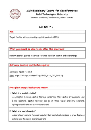
1. Multidisciplinary Centre for Geoinformatics
Delhi Technological University
Shahbad Daulatpur, Bawana Road, Delhi – 110042
LAB NO. 7 a
Aim
To get familiar with constructing spatial queries in QGIS
What you should be able to do after this practical?
Perform spatial queries on various features based on location and relationships
Software involved and DATA required
Software: QGIS – 3.20.3
Data: https://dst-iget.in/assets/zip/IGET_GIS_010_Data.zip
Principle/Concept/Background theory
1. What is a spatial relation?
A connection between spatial features concerning their spatial arrangements and
spatial locations. Spatial relations can be of three types: proximity relations,
topological relations and direction relations.
2. What are spatial queries?
A spatial query selects features based on their spatial relationships to other features
and are used to answer spatial questions
2. METHODOLOGY
Query 1: Find out the road segments in Maharashtra where road cross over the
river.
Data used: Shape files- ‘road_maha.shp’ and ‘River_Maha.shp’
Step 1: Open the QGIS Desktop from start menu
Step 2: In Menu bar: Layer > Add Layer > Add Vector Layer
Step 3: Add the vector Dataset(s) i.e., road_maha.shp and River_Maha.shp by Browsing.
Step 4: To perform spatial query by location.
Go to Vector > Research Tools > Select by Location
Or
Processing > Toolbox
3. Type ‘Select by location’ and chose the tool
Step 5: In the window opened,
Select Features from: Select ‘road_maha’ from the drop down list
Where the features (geometric predicate): Check the box beside ‘cross’
By Comparing to the features from: Select ‘River_Maha’
Modify current selection by: creating new selection
Click on Run
4. Step 6: The process takes some time to run.
Step 7: Close the window. You will notice that all the corresponding features are
highlighted in yellow color.
5. Step 8: To save the selected features as separate layer. Right click on the ‘road_maha’
layer in the Layer Bar (in the left) and Export > Save Selected Features As
Step 9: Save the layer with Format “ESRI Shapefile”
Step 10: To move to next query, deselect the selected features.
6. On selection toolbar, use ‘Deselect Features from all Layers’ option
Query 2: Find out the river channels that are not flowing through Ahmadnagar
District.
Data used: Shape files- ‘Maha_Tehsil.shp’ and ‘River_Maha.shp’
Step 1: Open the QGIS Desktop from start menu
Step 2: In Menu bar: Layer > Add Layer > Add Vector Layer
Step 3: Add the vector Dataset(s) i.e., Maha_Tehsil.shp and River_Maha.shp by
Browsing (keep the River_Maha layer on top of Maha_Tehsil layer)
7. Step 4: Since we want rivers flowing outside Ahmadnagar, firstly we will select
Ahmadnagar district from the Maharashtra state.
This can be done by using attribute query and we will perform spatial query on the
selected data from attribute query.
Right click on ‘Maha_Tehsil’ and select ‘Filter’.
Step 5: The query builder window gets opened. In this window, Select all the tehsils of
Ahmadnagar district by using attribute query, i.e., double click on "NAME_2" fromfields
window and click on click on ‘=’ in the ‘Operators’ section
8. Step 6: Then to see all the values in Name_2 field click on ‘All’ in ‘Values’ section in
window and select Ahmednagar from values
Step 7: In short we need to create an expression "NAME_2" = 'Ahmednagar' and Click
‘OK’.
9. Step 8: This will select all the tehsils from Ahmednagar district.
Step 9: To perform spatial query by location.
Go to Vector > Research Tools > Select by Location
Or
Processing > Toolbox
Type ‘Select by location’ and chose the tool
10. Step 10: In the window opened,
Select Features from: Select ‘River_Maha’ from the drop down list
Where the features (geometric predicate): Check the box beside ‘disjoint’
By Comparing to the features from: Select ‘Maha_Tehsil’
And use the result to: Create new selection
Click Apply
Click on Run
Step 11: The process takes some time to run.
Step 12: The river channels which are not flowing through Ahmadnagar would be
highlighted in yellow color in map canvas.
11. Step 13: To save the selected features as separate layer. Right click on the
‘River_Maha’ layer in the Layer Bar (in the left) and Export > Save Selected Features As
Step 14: Save the layer with Format “ESRI Shapefile”
Step 15: To move to next query, deselect the selected features.
On selection toolbar, use ‘Deselect Features from all Layers’ option
Query 3: Find out the public places that are within Greater Mumbai.
12. Data used: Shape files- ‘Maha_Tehsil.shp’ and ‘public_place_maha.shp’
Step 1: Open the QGIS Desktop from start menu
Step 2: In Menu bar: Layer > Add Layer > Add Vector Layer
Step 3: Add the vector Dataset(s) i.e., Maha_Tehsil.shp and public_place_maha.shp by
Browsing (keep the public_place_maha layer on top of Maha_Tehsil layer)
Step 4: Since we want public places inside Greater Mumbai, firstly we will select Greater
Bombay district from the Maharashtra state.
This can be done by using attribute query and we will
perform spatial query on the selected data from attribute
query.
Right click on ‘Maha_Tehsil’ and select ‘Filter’.
13. Step 5: The query builder window gets opened. In this window, Select all the tehsils of
Greater Bombay district by using attribute query, i.e., double click on "NAME_2" from
fields window and click on click on ‘=’ in the ‘Operators’ section.
Then to see all the values in Name_2 field click on ‘All’ in ‘Values’ section in window and
select Greater Bombay from values
In short we need to create an expression "NAME_2" = 'Greater Bombay' and Click ‘OK’.
Step 6: This will select all the tehsils
from Greater Bombay
14. Step 7: To perform spatial query by location.
Go to Vector > Research Tools > Select by Location
Or
Processing > Toolbox
Type ‘Select by location’ and chose the tool
Step 8: In the window opened,
Select Features from: Select ‘public_place_maha’ from the drop down list
Where the features (geometric predicate): Check the box beside ‘are within’
By Comparing to the features from: Select ‘Maha_Tehsil’
And use the result to: Create new selection
Click Apply
15. Click on Run
Step 9: The process takes some time to run. The public places which are present in the
Greater Bombay region gets highlighted in yellow
16. Step 10: To save the selected features as separate layer. Right click on the
‘public_place_maha’ layer in the Layer Bar (in the left) and Export > Save Selected
Features As
Step 11: Save the layer with Format “ESRI Shapefile”
Step 12: To move to next query, deselect the selected features.
On selection toolbar, use ‘Deselect Features from all Layers’ option
17. Query 4: Find out the schools in Maharashtra that could be affected by floods?
Let assume the flood zone is at about 3 km from the river bank.
Data used: Shape files- ‘School_col_Maha.shp’ and ‘River_Maha.shp’
Step 1: Open the QGIS Desktop from start menu
Step 2: In Menu bar: Layer > Add Layer > Add Vector Layer
Step 3: Add the vector Dataset(s) i.e., School_col_Maha.shp and River_Maha.shp by
Browsing
18. Step 4: To find out Rivers that could be affecting the schools in case floods, firstly we
have to create a flood zone around the rivers with 3 Km by using Buffer function. To
create a buffer around the river, Menu bar > Vector > Geoprocessing tools > Buffer…
Step 5: The ‘Buffer…’ window will open. Select Input vector layer as ‘River_Maha’.
Specify ‘Buffer Distance’ as 3km (Since our working unit is meter in UTM projection).
Rest of the parameters same. Save the output shapefile ( in desired location in local
drive with a proper name. This can be done with the help of browse button. Once the
inputs are given properly click on ‘OK’. If you asked to add the output layer to map canvas
click on yes.
Close the Buffer window and the output layer looks as follows:
19. Move the ‘School_col_Maha’ layer on the top of this newly created buffer layer.
Step 6: To perform spatial query by location.
Go to Vector > Research Tools > Select by Location
Or
Processing > Toolbox
Type ‘Select by location’ and chose the tool
20. Step 7: In the window opened,
Select Features from: Select ‘School_col_Maha’ from the drop down list
Where the features (geometric predicate): Check the box beside ‘are within’
By Comparing to the features from: Select ‘Buffer’
And use the result to: Create new selection
Click Apply
Click on Run
Step 8: The process takes some time to run. The schools which are present in the 3 KM
region to the rivers gets highlighted in yellow
21. Step 9: To save the selected features as separate layer. Right click on the
‘School_col_maha’ layer in the Layer Bar (in the left) and Export > Save Selected
Features As
22. Step 10: Save the layer with Format “ESRI Shapefile”
Step 11: To move to next query, deselect the selected features.
On selection toolbar, use ‘Deselect Features from all Layers’ option
Query 5: Find out the tehsils in Pune which contains water bodies such as lakes
and Dams?
Data used: Shape files- ‘waterbodies_maha.shp’ and ‘Maha_Tehsil.shp’
Step 1: Open the QGIS Desktop from start menu
Step 2: In Menu bar: Layer > Add Layer > Add Vector Layer
23. Step 3: Add the vector Dataset(s) i.e., waterbodies_maha.shp and Maha_Tehsil.shp by
Browsing (Keep the waterbodies_Maha layer over Maha_Tehsil)
Step 4: Since we want water bodies inside Pune, firstly we will select Pune district from
the Maharashtra state.
This can be done by using attribute query and we will perform spatial query on the
selected data from attribute query.
Right click on ‘Maha_Tehsil’ and select ‘Filter’.
Step 5: The query builder window gets opened. In this window, Select all the tehsils of
Pune district by using attribute query, i.e., double click on "NAME_2" from fields window
and click on click on ‘=’ in the ‘Operators’ section.
Then to see all the values in Name_2 field click on ‘All’ in ‘Values’ section in window and
select Pune from values
In short, we need to create an expression "NAME_2" = 'Pune' and Click ‘OK’.
24. Step 6: This will select all the tehsils from Pune.
Step 7: To perform spatial query by location.
25. Go to Vector > Research Tools > Select by Location
Or
Processing > Toolbox
Type ‘Select by location’ and chose the tool
Step 8: In the window opened,
Select Features from: Select ‘Maha_Tehsil’ from the drop down list
Where the features (geometric predicate): Check the box beside ‘contain’
By Comparing to the features from: Select ‘waterbodies_Maha’
And use the result to: Create new selection
Click Apply
26. Click on Run
Step 9: The process takes some time to run. The tehsils of Pune which contain water
bodies gets highlighted in yellow.
27. Step 10: To save the selected features as separate layer. Right click on the
‘Maha_tehsil’ layer in the Layer Bar (in the left) and Export > Save Selected Features
As
Step 11: Save the layer with Format “ESRI Shapefile”
Step 12: deselect the selected features.
On selection toolbar, use ‘Deselect Features from all Layers’ option
28. Observations
1. Correctly define the options: Select Features from and By comparing to the
features from
2. Selection and Extraction of required features can be done by this practical.
TEST YOUR KNOWLEDGE
1. How can we find the number of schools affected by the flood in Query 4 ?
2. What are the various types of spatial relations?
3. Is there any other way to select and save the required queried features
directly ?