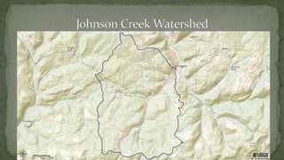
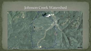
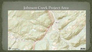
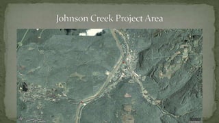
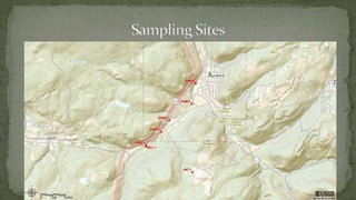
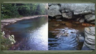
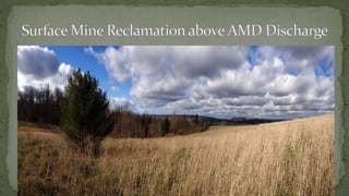
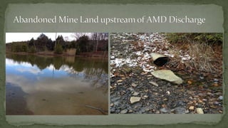
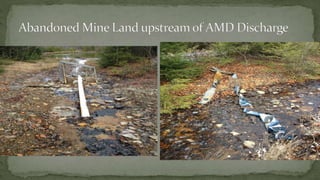
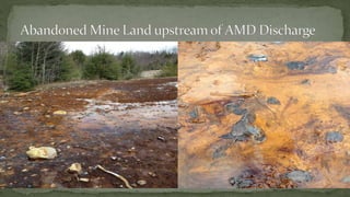
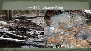
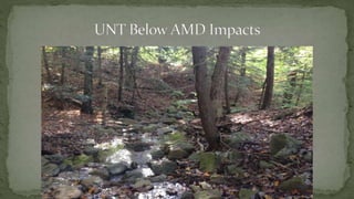
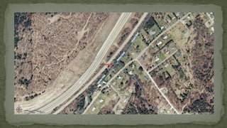
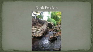
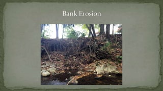
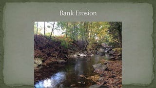
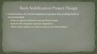
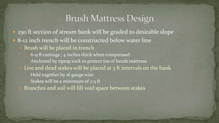
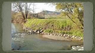
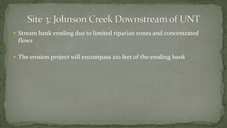
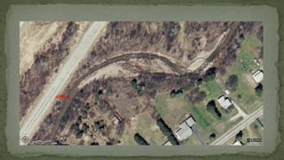
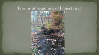
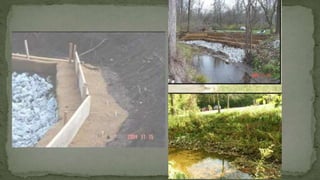
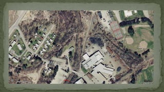
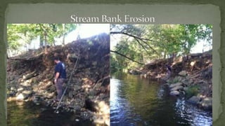
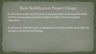
By:
Cory Sauvé, Lacy Powers, Jesse Jones, Louis Sick, and Glenn Wolfe
ď‚— Goal is to restore the Johnson Creek Watershed through:
ď‚— Stream bank stabilization projects
ď‚— Abandoned mine drainage remediation
ď‚— Project area will focus on a two mile portion of Johnson Creek and its
tributaries
ď‚— Rt. 15 bridge to the mouth at the Tioga River
ď‚— Improve water quality and aquatic habitat to increase the diversity and
health of fish and macroinvertebrate communities.
ď‚— Will improve the recreational opportunities found in the watershed
ď‚— Increase community education on the importance of the Johnson Creek
Watershed through interactive seminars and opportunities to volunteer.
ď‚— Will encourage stewardship for generations to come
ď‚— Johnson Creek Watershed
ď‚— Drainage basin is 17.4 square miles
ď‚— Bloss and Hamilton Township
ď‚— Blossburg and Cherry Flats USGS topographic maps
ď‚— Project Area
ď‚— 2 Mile section of Johnson Creek and its tributaries
ď‚— Bellman Run, Boone Run, Mills Creek, and several unnamed tributaries
ď‚— Drainage area is 5.6 square miles
ď‚— Johnson Creek is on the 303d list
ď‚— Impaired for metals: Iron, manganese, and aluminum
ď‚— Result of coal mining operations in the watershed
ď‚— The Department of Environmental Protection has conducted studies on
Johnson Creek.
ď‚— Studies showed high levels of tolerant taxa indicative of impaired water
bodies.
ď‚— Habitat assessments identified stream bank erosion and poor riparian buffer
zones as recurring issues in the watershed.
ď‚— Mainly forested , no agricultural activities
ď‚— Residential and industrial land use near Arnot and Blossburg
ď‚— Sewage discharges, increased erosion, stream channelization, and bank cementation
ď‚— Abandoned strip mines
ď‚— Main source of pollution
ď‚— 36 acres of abandoned mine land in project area.
ď‚— Little recreational uses in watershed besides hunting.
ď‚— Located approximately 100 meters upstream of bridge at South Williamson
Road.
ď‚— Good tree cover over the stream and healthy riparian buffer zone.
ď‚— Small amounts of undercutting along the stream.
ď‚— The substrate is most cobble and boulder , very little silt
ď‚— A strong presence of macroinvertebrates
ď‚— Located about 1 mile upstream of the confluence with Johnson creek.
ď‚— Forested riparian zone, completely shaded
ď‚— Abandoned mine land upstream of site
ď‚— Substrate consisted of mostly cobble with no silt prevalent.
ď‚— Woody debris in stream
ď‚— Visual iron and aluminum precipitate were present
ď‚— No marcoinvertebrate communities were present
ď‚— Located 100 meters upstream of the confluence with Bellman Run.
ď‚— Stream channel was mostly shaded
ď‚— Good riparian buffer on both banks; some bank erosion.
ď‚— The substrate consisted of gravel with little cobble. Some silt and sand
were present
ď‚— Macroinvertebrate communities was present.
ď‚— Taxa consisted of mainly caddis and midges.
ď‚— Located 100 meters upstream from the confluence with the unnamed
tributary.
ď‚— Stream channel was mostly shaded with about 50 percent residential and
forested land use.
ď‚— Little to no riparian zone on the south bank from residential structures
ď‚— Severe erosion was present along the exposed bank.
ď‚— Substrate was very poor consisting of silt and sands. Some gravel and
boulder formations were present.
ď‚— Macroinvertebrate communities were present.
ď‚— Located 300 meters downstream from the unnamed tributary and
Johnson creek confluence.
ď‚— Partly shaded and mostly residential and forested land use.
ď‚— Severe stream bank erosion along both banks
ď‚— Macroinvertebrate communities were present at the site
ď‚— Located 50 meters upstream of the Tabor Street bridge in Blossburg.
ď‚— Limited canopy cover and marginal riparian zones were present.
ď‚— Multiple industrial and storm water discharges were found within this site
location.
ď‚— The substrate consisted of mostly silt and sand. Very small amounts of
gravel and boulder were present.
ď‚— Located 100 meters upstream of the mouth at the Tioga River.
ď‚— The steam was partially shaded and had marginal riparian zones on either
side of the creek.
ď‚— There were several discharge points along both stream banks.
ď‚— The substrate consisted of mostly silt and sand with very small amounts of
gravel and cobble.
ď‚— Limited macroinvertabrate communities were present.
ď‚— Visible iron and aluminum precipitate was present at the confluence with
the Tioga River.
ď‚— Located 1 mile upstream of the confluence of Johnson Creek.
ď‚— Significant abandoned mine land in the area.
ď‚— Remainder of the land is forested.
ď‚— Site is completely shaded and has large forested riparian buffer zones.
ď‚— Substrate is composed of cobble, with no silt.
ď‚— Passive treatment system parameters
ď‚— 50 gpm design flow
ď‚— pH= 3.48
ď‚— Iron = 1.50 mg/L
ď‚— Aluminum = 9.00 mg/L
ď‚— Manganese = 1.20 mg/L
ď‚— Alkalinity = 0.00 mg/L
ď‚— Treatment Train
ď‚— 1. Vertical Flow Wetland
ď‚— 162 ft X 93 ft at top of freeboard
ď‚— 3 ft of limestone, 2 feet of OM, and 3 ft of water
ď‚— Piping system to flush Aluminum
ď‚— 2. Settling Pond
ď‚— 3. Limestone Bed
ď‚— 4. Polishing aerobic wetland
ď‚— 131 ft X 68 ft at top of freeboard
ď‚— Stream bank stability reduced by limited riparian zone and residential
structures
ď‚— Stream stabilization project will take place along a 250 ft section that is
experiencing stream bank erosion.
ď‚— Construction of a brush mattress to protect the eroding bank is
recommended .
ď‚— Help to capture sediment during flood events
ď‚— Restore the marginal riparian vegetation
ď‚— Allow native plants to colonize area to increase habitat
ď‚— 250 ft section of stream bank will be graded to desirable slope
ď‚— 8-12 inch trench will be constructed below water line
ď‚— Brush will be placed in trench
ď‚— 6-9 ft cuttings ; 4 inches thick when compressed
ď‚— Anchored by riprap rock to protect toe of brush mattress
ď‚— Live and dead stakes will be placed at 3 ft intervals on the bank
ď‚— Held together by 16 gauge wire
ď‚— Stakes will be a minimum of 2.5 ft
ď‚— Branches and soil will fill void space between stakes
ď‚— Stream bank eroding due to limited riparian zones and concentrated
flows
ď‚— The erosion project will encompass 210 feet of the eroding bank
ď‚— Combination of a soil terrace and biologs is recommended.
ď‚— Soil terrace will stabilize eroding stream bank.
ď‚— Biologs will prevent erosion along channel bottom.
ď‚— Biologs will be installed along the first 60 ft of the graded bank.
ď‚— Soil Terrace along remaining 150 ft of eroding bank.
ď‚— Banks will be graded to a favorable slope
ď‚— Layer of riprap stone will be placed at bottom layer to protect toe of terrace
ď‚— Soil terraces will be compacted and covered by heavy jute blankets
ď‚— Layers of brush will be placed between soil layers to increase stability
ď‚— Soil will be fastened by wood stakes
ď‚— Project will give bank stability and increase the riparian vegetation along
the stream bank.
ď‚— The steam banks are eroding at this site due to limited riparian zones from
industrial activity in the area.
ď‚— Erosion project will include a 475 ft section of the east bank of the stream.
ď‚— A soil terrace at the 475 ft section is recommended to increase the bank
stability and promote increased riparian buffer zones from native
vegetation.
ď‚— A soil terrace with the same components from Site 3 will be used with the
exception of the 60 ft of biologs.

PowerPoint Presentation(1)

  • 1.
    By: Cory Sauvé, LacyPowers, Jesse Jones, Louis Sick, and Glenn Wolfe
  • 2.
    ď‚— Goal isto restore the Johnson Creek Watershed through: ď‚— Stream bank stabilization projects ď‚— Abandoned mine drainage remediation ď‚— Project area will focus on a two mile portion of Johnson Creek and its tributaries ď‚— Rt. 15 bridge to the mouth at the Tioga River
  • 3.
    ď‚— Improve waterquality and aquatic habitat to increase the diversity and health of fish and macroinvertebrate communities. ď‚— Will improve the recreational opportunities found in the watershed ď‚— Increase community education on the importance of the Johnson Creek Watershed through interactive seminars and opportunities to volunteer. ď‚— Will encourage stewardship for generations to come
  • 4.
    ď‚— Johnson CreekWatershed ď‚— Drainage basin is 17.4 square miles ď‚— Bloss and Hamilton Township ď‚— Blossburg and Cherry Flats USGS topographic maps ď‚— Project Area ď‚— 2 Mile section of Johnson Creek and its tributaries ď‚— Bellman Run, Boone Run, Mills Creek, and several unnamed tributaries ď‚— Drainage area is 5.6 square miles
  • 9.
    ď‚— Johnson Creekis on the 303d list ď‚— Impaired for metals: Iron, manganese, and aluminum ď‚— Result of coal mining operations in the watershed ď‚— The Department of Environmental Protection has conducted studies on Johnson Creek. ď‚— Studies showed high levels of tolerant taxa indicative of impaired water bodies. ď‚— Habitat assessments identified stream bank erosion and poor riparian buffer zones as recurring issues in the watershed.
  • 10.
    ď‚— Mainly forested, no agricultural activities ď‚— Residential and industrial land use near Arnot and Blossburg ď‚— Sewage discharges, increased erosion, stream channelization, and bank cementation ď‚— Abandoned strip mines ď‚— Main source of pollution ď‚— 36 acres of abandoned mine land in project area. ď‚— Little recreational uses in watershed besides hunting.
  • 13.
    ď‚— Located approximately100 meters upstream of bridge at South Williamson Road. ď‚— Good tree cover over the stream and healthy riparian buffer zone. ď‚— Small amounts of undercutting along the stream. ď‚— The substrate is most cobble and boulder , very little silt ď‚— A strong presence of macroinvertebrates
  • 14.
    ď‚— Located about1 mile upstream of the confluence with Johnson creek. ď‚— Forested riparian zone, completely shaded ď‚— Abandoned mine land upstream of site ď‚— Substrate consisted of mostly cobble with no silt prevalent. ď‚— Woody debris in stream ď‚— Visual iron and aluminum precipitate were present ď‚— No marcoinvertebrate communities were present
  • 15.
    ď‚— Located 100meters upstream of the confluence with Bellman Run. ď‚— Stream channel was mostly shaded ď‚— Good riparian buffer on both banks; some bank erosion. ď‚— The substrate consisted of gravel with little cobble. Some silt and sand were present ď‚— Macroinvertebrate communities was present. ď‚— Taxa consisted of mainly caddis and midges.
  • 16.
    ď‚— Located 100meters upstream from the confluence with the unnamed tributary. ď‚— Stream channel was mostly shaded with about 50 percent residential and forested land use. ď‚— Little to no riparian zone on the south bank from residential structures ď‚— Severe erosion was present along the exposed bank. ď‚— Substrate was very poor consisting of silt and sands. Some gravel and boulder formations were present. ď‚— Macroinvertebrate communities were present.
  • 17.
    ď‚— Located 300meters downstream from the unnamed tributary and Johnson creek confluence. ď‚— Partly shaded and mostly residential and forested land use. ď‚— Severe stream bank erosion along both banks ď‚— Macroinvertebrate communities were present at the site
  • 18.
    ď‚— Located 50meters upstream of the Tabor Street bridge in Blossburg. ď‚— Limited canopy cover and marginal riparian zones were present. ď‚— Multiple industrial and storm water discharges were found within this site location. ď‚— The substrate consisted of mostly silt and sand. Very small amounts of gravel and boulder were present.
  • 19.
    ď‚— Located 100meters upstream of the mouth at the Tioga River. ď‚— The steam was partially shaded and had marginal riparian zones on either side of the creek. ď‚— There were several discharge points along both stream banks. ď‚— The substrate consisted of mostly silt and sand with very small amounts of gravel and cobble. ď‚— Limited macroinvertabrate communities were present. ď‚— Visible iron and aluminum precipitate was present at the confluence with the Tioga River.
  • 22.
    ď‚— Located 1mile upstream of the confluence of Johnson Creek. ď‚— Significant abandoned mine land in the area. ď‚— Remainder of the land is forested. ď‚— Site is completely shaded and has large forested riparian buffer zones. ď‚— Substrate is composed of cobble, with no silt.
  • 30.
    ď‚— Passive treatmentsystem parameters ď‚— 50 gpm design flow ď‚— pH= 3.48 ď‚— Iron = 1.50 mg/L ď‚— Aluminum = 9.00 mg/L ď‚— Manganese = 1.20 mg/L ď‚— Alkalinity = 0.00 mg/L
  • 31.
    ď‚— Treatment Train ď‚—1. Vertical Flow Wetland ď‚— 162 ft X 93 ft at top of freeboard ď‚— 3 ft of limestone, 2 feet of OM, and 3 ft of water ď‚— Piping system to flush Aluminum ď‚— 2. Settling Pond ď‚— 3. Limestone Bed ď‚— 4. Polishing aerobic wetland ď‚— 131 ft X 68 ft at top of freeboard
  • 32.
    ď‚— Stream bankstability reduced by limited riparian zone and residential structures ď‚— Stream stabilization project will take place along a 250 ft section that is experiencing stream bank erosion.
  • 37.
    ď‚— Construction ofa brush mattress to protect the eroding bank is recommended . ď‚— Help to capture sediment during flood events ď‚— Restore the marginal riparian vegetation ď‚— Allow native plants to colonize area to increase habitat
  • 38.
    ď‚— 250 ftsection of stream bank will be graded to desirable slope ď‚— 8-12 inch trench will be constructed below water line ď‚— Brush will be placed in trench ď‚— 6-9 ft cuttings ; 4 inches thick when compressed ď‚— Anchored by riprap rock to protect toe of brush mattress ď‚— Live and dead stakes will be placed at 3 ft intervals on the bank ď‚— Held together by 16 gauge wire ď‚— Stakes will be a minimum of 2.5 ft ď‚— Branches and soil will fill void space between stakes
  • 41.
    ď‚— Stream bankeroding due to limited riparian zones and concentrated flows ď‚— The erosion project will encompass 210 feet of the eroding bank
  • 45.
    ď‚— Combination ofa soil terrace and biologs is recommended. ď‚— Soil terrace will stabilize eroding stream bank. ď‚— Biologs will prevent erosion along channel bottom.
  • 46.
    ď‚— Biologs willbe installed along the first 60 ft of the graded bank. ď‚— Soil Terrace along remaining 150 ft of eroding bank. ď‚— Banks will be graded to a favorable slope ď‚— Layer of riprap stone will be placed at bottom layer to protect toe of terrace ď‚— Soil terraces will be compacted and covered by heavy jute blankets ď‚— Layers of brush will be placed between soil layers to increase stability ď‚— Soil will be fastened by wood stakes ď‚— Project will give bank stability and increase the riparian vegetation along the stream bank.
  • 48.
    ď‚— The steambanks are eroding at this site due to limited riparian zones from industrial activity in the area. ď‚— Erosion project will include a 475 ft section of the east bank of the stream.
  • 51.
    ď‚— A soilterrace at the 475 ft section is recommended to increase the bank stability and promote increased riparian buffer zones from native vegetation. ď‚— A soil terrace with the same components from Site 3 will be used with the exception of the 60 ft of biologs.