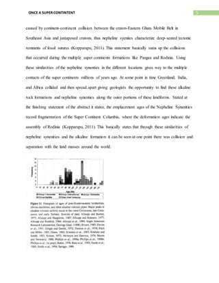
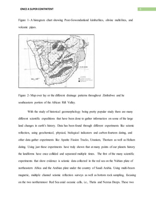
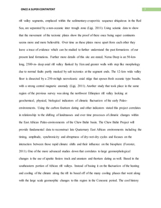
1. 1ONCE A SUPER CONTINTENT
Once a Super Continent
Jesse Jones
Mansfield University
Historical Geology
12/3/15
2. 2ONCE A SUPER CONTINTENT
Was there at one point a Super Continent on planet earth? Throughout many articles and
reviews scientist have been studying the geological correlations of our earth for years and with
several geologic theories and scientific data to support. Many of the puzzle pieces are being put
together with geological studies in many regions of the world in present time and the past. One
of the best land marks that can be used to prove there was once a creation of one large super
continent is the Great African Rift Valley along the East coast of Africa. Many
geomorphological changes have occurred over the millions of years. Geologists in the last
decade have been uncovering support that may help correlate back to the breakup of the latest
super continents called Pangea and Rodinia. Different drainage patterns and uplifts along the
African Rift Valley as well as core samplings that have been taken to show at one point there
were large scale tectonic and hydrologic events that played a role in the geomorphological
changes to the huge land mass that there once was.
Concentrating this study to the African Rift Valley gives way to different data
sources that find correlation in the landscape around the valley that supports the deformation of a
past super continent. When looking for large scale geomorphological changes one of best
variables to look for is similarities in rock formations and erosional patterns of the landscape.
Using the formation and deformation of drainage patterns is basically a door of curiosity for a
geologist. Throughout the African Rift there are sites all over the east coast and more inland as
well. Some of the best sites to find similar geomorphic change would be in the southeastern
region of the African Rift where a very extensive study took place comparing the drainage
patterns of different rivers and tributaries throughout Zimbabwe Africa. This study primarily
looked at the divide between the Orange-Vaal River system and the Limpopo and Molopo-
Nossib-Auob drainage basins is designated the Etosha Griquland (Moore, 1999). With this said
3. 3ONCE A SUPER CONTINTENT
some of the physical geology was sought out and documented there are several connections
along the rivers and their basins. Stated in the document, an alluvial gravel run (paleo drainage at
Lichtenburg located on the crest of the trans-Griqualand axis (Fig 1), contains distinctive red
aggregates very similar to these found in the Bushveld Amygdaloid. The volcanic unit occurs at
a lower altitude within the Bushveld basin to the northeast, arguing for crustal deformation
(subsidence of the Bushveld basin subsequent to deposition of the gravels (Moore, 1999). This
has straight proof finding similar geology in two different bodies of water at a close proximity.
With the decrease in altitude between the two axes gives way to the rifting of land formation
creating subsidence in the land in which changes the flow of a single body of water creating two
different bodies of the same origin. Throughout this article the term flexuring was used in
regards of the uplifting and deformation of the bodies of water throughout this region of
Zimbabwe. As the rifting occurs inland flexuring of the land changes the course of the drainage
basins and river systems. Another example of land deformation presented in this research took
place in the Vaal-Harts Rivers systems. Stated in the article, evidence for uplift along the
watershed between the Vaal-Harts Rivers argues that crustal flexuring along such an axis could
account for the differing character and gradients of the tributaries on either side of the major pan
field to the southeast of the Vaal River, and river captured which modified the former Vaal and
Harts drainage lines (Moore, 1999). This being said, with uplift being prevalent in this site
location would give way to similar sedimentation on either side of these rivers. This would then
create similar geological features on either side on the uplift. The slope may be different on one
side of the uplift but similar geological features will still be prevalent depending on the rate of
the drainage of each river. Later in the research Moore goes on to speak about the physical
erosion of a waterfall made from the Orange and Molopo Rivers called the Augrabies Falls.
4. 4ONCE A SUPER CONTINTENT
Stated in this paragraph, the steep gradient of the Molopo below the Riemvasmaal argues for
rejuvenation of the drainage. It is suggested that this was initiated once headwater erosion of the
Augrabies Falls had advanced upstream of the Molopo- Orange confluence at some stage
following the inferred crustal flexuring. This would account for the similarity of the profiles of
the lower and Molopo and the section of the Orange downstream of the falls (Moore, 1999).
With this being said, this major water event gives way to some land deformation with the
creation of the Augrabies Falls. Also noticing that both the Orange River which is downstream of
this falls has similar features of the upstream river of the Molopo River system. With this rifting
occurring over a long period of time it can play a huge role in the changing of flow and drainage
patterns. By looking at the similar features of close by river systems connections can be made if
there was once just one larger river that was broken into two at one point in its life.
Another good site to take into account is other continents having similar geological content along
the outer perimeter. This has been seen throughout Greenland, Africa, and India. All three of
these land masses have similar rock content along the outer portions of each land formation.
Stated in an article written on alkaline rock formations, Nepheline syenites and carbonates mark
continental rift margins from the Mesoproterozoic Gardar provinces in the Greenland to the
Cenozoic East African Rift (Kopparapu, 2011). There are correlations being made in different
areas of the world that key to the Super Continental contacts. Using these alkaline rock
formations there is suitable support for there once having multiple land masses having been
connected at one point in time. These nepheline syenities are a reliable source of comparison in
similar alkaline and carbonic formations. Another excerpt from this abstract supports that there
was once at one point a super continent. The nepheline synenties are considered to have
originally formed in a rift on the thickened of continental crust. The subsequent deformation was
5. 5ONCE A SUPER CONTINTENT
caused by continent-continent collision between the craton-Eastern Ghats Mobile Belt in
Southeast Asia and juxtaposed cratons, thus nepheline syenites characterize deep-seated tectonic
remnants of fossil sutures (Kopparapu, 2011). This statement basically sums up the collisions
that occurred during the multiple super continents formations like Pangea and Rodinia. Using
these similarities of the nepheline synenties in the different locations gives way to the multiple
contacts of the super continents millions of years ago. At some point in time Greenland, India,
and Africa collided and then spread apart giving geologists the opportunity to find these alkaline
rock formations and nepheline synenties along the outer portions of these landforms. Stated at
the finishing statement of the abstract it states, the emplacement ages of the Nepheline Synenities
record fragmentation of the Super Continent Columbia, where the deformation ages indicate the
assembly of Rodinia (Kopparapu, 2011). This basically states that through these similarities of
nepheline synenities and the alkaline formation it can be seen at one point there was collision and
separation with the land masses around the world.
6. 6ONCE A SUPER CONTINTENT
Figure 1- A histogram chart showing Post-Gowondanland kimberlites, olivine melitilites, and
volcanic pipes.
Figure 2- Map over lay or the different drainage patterns throughout Zimbabwe and he
southeastern portion of the African Rift Valley.
With the study of historical geomorphology being pretty popular study there are many
different scientific expeditions that have been done to gather information on some of the large
land changes in earth’s history. Data has been found through different experiments like seismic
reflection, using geochemical, physical, biological indicators and carbon fourteen dating, and
other data gather experiments like Apatite Fission Tracks, Uranium, Thorium as well as Helium
dating. Using just these experiments have truly shown that at many points of our planets history
the landforms have once collided and separated multiple times. The first of the many scientific
experiments that show evidence is seismic data collected in the red sea on the Nubian plate of
northeastern Africa and the Arabian plate under the country of Saudi Arabia. Using multi-beam
magnetic, multiple channel seismic reflection surveys as well as bottom rock sampling, focusing
on the two northernmost Red Sea axial oceanic cells, i.e., Thetis and Nereus Deeps. These two
7. 7ONCE A SUPER CONTINTENT
rift valley segments, emplaced within the sedimentary-evaporitic sequence ubiquitous in the Red
Sea, are separated by a non-oceanic inter trough zone (Ligi, 2011). Using seismic data to show
that the movement of the tectonic plates show the proof of there once being super continents
seems more and more believable. Over time as these plates move apart from each other they
leave a trace of evidence which can be studied to further understand the past formations of our
present land formations. Further more details of this site are stated, Nerus Deep is an 50-km-
long, 2500-m- deep axial rift valley flanked by 1km and greater walls with step like morphology
due to normal faults partly masked by salt tectonics at the segment ends. The 12-km- wide valley
floor is dissected by a 250-m-high neovolcanic axial ridge that eposes fresh oceanic type basalts,
with a strong central magnetic anomaly (Ligi, 2011). Another study that took place in the same
region of the previous survey was along the northwest Ethiopian rift valley looking at
geochemical, physical, biological indicators of climatic fluctuation of the early Paleo-
environments. Using the carbon fourteen dating and other indicators stated this project correlates
in relationship to the shifting of landmasses and over time processes of climatic changes within
the East African Paleo-environments of the Chew Bahir basin. The Chew Bahir Project will
provide fundamental data to reconstruct late Quaternary East African environments including the
timing, amplitude, synchronicity and abruptness of dry-wet-dry cycles and focuses on the
interaction between those rapid climate shifts and their influence on the biosphere (Forester,
2011). One of the more advanced studies down that correlates to large geomorphological
changes is the use of apatite fission track and uranium and thorium dating as well. Based in the
southeastern portion of African rift valleys. Instead of basing it on the fluctuation of the heating
and cooling of the climate along the rift its based off of the many cooling phases that went along
with the large scale geomorphic changes to this region in the Cenozoic period. The cool history
8. 8ONCE A SUPER CONTINTENT
of the Kenya rift flanks was studied by Forster and Gleadow using apatite fission track
thermochronology which monitors the thermal evolution of rocks between 110 degrees celsius
and 60 degrees celsius within the earth’s upper crust. These studies demonstrate that erosion
levels of the gaben shoulder were not deep enough to expose rocks that cooled through this
temperature range during the Cenozoic. Therefore, AFT data from the surface exposures
essentially document the Mesozoic structural evolution of the Central Kenya, but insensitive to
the cooling history directly related to the Cenozoic rift formations (Spiegel, 2007).Using these
age dating processes helps these scientists understand the change in the environments and when
they occurred. Using the cooling phases of the rock formations of the eastern and western flanks
of the rift zone throughout Kenya gives good evidence of when the super continent changes
started to happen. With this same study the use of uranium thorium, helium dating played a key
role in attaining data results. Having used these elements to date early mankind environments
results found that, combining AFT and Ahe data reveals that development of the Kenya rift
flanks are characterized by three major cooling episodes during the Early Cretaceous, Late
Cretaceous, and the late Neogene, with intermittent periods of slow to very slow cooling. All
three episodes can be related to major rifting periods and coincide with enhanced alkaline
magmatic activity across Africa, suggesting that they are a continent wide significance (Forster
et al, 1992-1996). Using these dating processes truly marks when large changes in our land
forms occurred. Over time the sediment material will be exposed along these shallow rift flanks
of Kenya and will open up more studies in the future for geologists to understand the magnitude
9. 9ONCE A SUPER CONTINTENT
of the changes to the super continents and the environments they inhibited during these masses
changes.
Figure 3- A histogram of apatite fission track ages for sampling sites from transects of
escarpments in South Africa.
One of the more basic but staple concepts known for the changing of our landforms over
time is the movement of the tectonic plates. These slow but large scale movements have been
seen throughout the paper, and play a key role in the transformation of the different super
continents that were formed and separated millions of years ago. One of the best sites studied
shows that the separation is still occurring in the Red Sea. Since the late Oligocene-Miocene
times, a rift system has been fragmenting the Arabian-Nubian shield, which consists of ancient
islands, arc back arc basins, continental microplates, and interlaying ocean basins, welded
together during the Proterozoic Pan-African orogenic cycle (Ghebreab, 1998). Still today the
expansion of the oceans and seas are still occurring today in the northern African rift. The
tracking of the magmatic processes of these rifting valleys within the red sea and other places
10. 10ONCE A SUPER CONTINTENT
like the India and Greenland show that tectonics and the backbone of the expanding and
contracting of the continents throughout the world. The Pan-African ages probably record
growth of new magmatic zircons in a fluid-rich environments and due to decompression melting
of the older nepheline syenites in the underlying lithospheric mantle. The emplacement ages of
nepheline synenites record fragmentation of the supercontinent Columbia, whereas the
deformation ages indicating the assembly of the super continent Rodina (Kopparau, 2011). Track
traces of alkaline rock coincides with tectonic movements. These characteristics of magmatism,
volcanism, and the formation of alkaline basaltic rocks give way to supporting the theory of the
root process of the Wilson Cycle and the tectonic movements.
Figure 4- Here is a diagram of the plate tectonic movements occuring in the northeastern section
of the African Rift Valley as well in relation to the Red Sea Rift.
Many geomorphological changes have occurred over millions of years. Geologists in the
last couple of decades have been uncovering supporting evidence that may help correlate back to
the breakup of the earliest Super Continents. Different drainage basins and uplifts along the
African Rift Valley as well as core samplings that have been taken show at one point that there
were large scale water events that may have played a role in the large geomorphic changes as
well as the relationship between tectonic and the creation of new ocean fronts as well as the
laying down of very young rock on the sea and oceanic floors throughout the world. With these
events still occurring in present day it makes it easier for scientist it get a gist of the magnitude of
11. 11ONCE A SUPER CONTINTENT
landform changes that occurred millions of years ago. Looking to the future for what these
geologists and geomorphologists have found in the African, Indian rift regions is that some
oceans are expanding moving these landmass little bits at a time and in other areas of the world
oceans are coming together. Sometime in the future millions of years from now at some point
these large areas of land will come back together once again for an historic change of our planet.
12. 12ONCE A SUPER CONTINTENT
Reference Page
Foerster, V. E. "The Chew Bahir Project, Southern Ethiopia; Reconstructing East African
Palaeoenvironments In The Source Region Of Modern Man." American Geophysical
Union Fall Meeting 2011. (2011): @AbstractGC51H-1119. GeoRef. Web. 3 Sept. 2015
Kopparapu, V., W. G. Ernst, and L. Chervela. "Opening And Closing Of A Mesoproterozoic
Ocean Along The SE Margin Of India; Textural, Cathodoluminescence And SHRIMP
Analyses Of Zircon." American Geophysical Union Fall Meeting 2011. (2011):
@AbstractV14B-07. GeoRef. Web. 3 Sept. 2015.
Ligi, Marco, et al. "Initial Burst Of Oceanic Crust Accretion in the Red Sea Due To Edge-Driven
Mantle Convection." Geology [Boulder] 39.11 (2011): 1019-1022. GeoRef. Web. 3 Sept.
2015.
Moore, A. E. "A Reappraisal Of Epeirogenic Flexure Axes In Southern Africa." South African
Journal of Geology 102.4 (1999): 363-376. GeoRef. Web. 3 Sept. 2015.
Spiegel, Cornelia, et al. "Morph tectonic Evolution of the Central Kenya Rift Flanks;
Implications For Late Cenozoic Environmental Change In East Africa." Geology
[Boulder] 35.5 (2007): 427-430. GeoRef. Web. 3 Sept. 2015.