SlideShare a Scribd company logo
Ground-based Cloud detection using a digital camera above Manila Observatory (14.64N, 121.07E)
Gacal,GlennFranco1
;Francis,Tan1
;Antioquia,Carlo1
;andLagrosas,Nofel1,2
1
Ateneode ManilaUniversity,KatipunanAve., QuezonCityPhilippines
2
ManilaObservatory,AteneodeManilaUniversitycampus,KatipunanAve.,QuezonCityPhilippines
Cloud detection during nighttime poses a real problem to researchers because of a lack of optimum sensors that can
specifically detect clouds during this time of the day. Hence, lidars and satellites are currently some of the instruments
that are being utilized to determine cloud presence in the atmosphere. These clouds play a significant role in the night
weather system for the reason that they serve as barriers of thermal radiation from the Earth and thereby reflecting this
radiation back to the Earth. This effectively lowers the rate of decreasing temperature in the atmosphere at night. The
objective of this study is to detect cloud occurrences at nighttime for the purpose of studying patterns of cloud occur-
rence and the effects of clouds on local weather. In this study, a commercial camera (Canon Powershot A2300) is op-
erated continuously to capture nighttime clouds. The camera is situated inside a weather-proof box with a glass cover
and is placed on the rooftop of the Manila Observatory building to gather pictures of the sky every 5min to observe
cloud dynamics and evolution in the atmosphere. To detect pixels with clouds, the pictures are converted from its na-
tive JPEG to grayscale format. The pixels are then screened for clouds by looking at the values of pixels with and
without clouds. In grayscale format, pixels with clouds have greater pixel values than pixels without clouds. Based on
the observations, a threshold pixel value of 17 is enough to discern pixels with clouds from pixels without clouds.
Figs. 1a & 1b are sample unprocessed pictures of cloudless night (May 22-23, 2014) and cloudy skies (May 23-24,
2014), respectively. Figs.1c and 1d show percentage of occurrence of nighttime clouds on May 22-23 and May 23-24,
2014, respectively. The cloud occurrence in a pixel is defined as the ratio of the number times when the pixel has
clouds to the total number of observations. Fig. 1c shows less than 50% cloud occurrence while Fig. 1d shows cloud
occurrence more than what is shown in Fig. 1c. These graphs show the capability of the camera to detect and measure
the cloud occurrence at nighttime. Continuous collection of nighttime pictures is currently implemented. In regions
where there is a dearth of scientific data, the measured nighttime cloud occurrence will serve as a baseline for future
cloud studies in this part of the world.
Methodology:
Location
Capture images of the sky
above Manila Observatory at 5
minute interval.
Algorithm converts one night
worth of pictures from its native
RGB to greyscale format.
Pixel
value > 17
Count as
Cloud
The Manila Observatory (14.6367° N,
121.0767° E) is a private non-stock, non-
profit, scientific research institution estab-
lished in 1865 by the Jesuit mission in the
Philippines. The Observatory finds itself at
the nexus of global concerns for environment
and development. With its tradition of excel-
lence and service in scientific research, the
Observatory envisions itself as a vital partner
in these critically global yet locally relevant
concerns.
Image without Clouds:
RGB format
Cloud Occurrence:
This work has shown that nighttime clouds can be detected using a ground based digital camera. Continuous gathering
of images can lead to measurements of nighttime cloud occurrence. Clouds are discerned from pixel values by apply-
ing the threshold value of 17 from grayscale images. Further work is still needed to analyze nighttime images with rain
droplets and moon signals. The occurrence of these variables destroy the pixel information of cloud signals. In the fu-
ture, with continuous gathering of images, the cloud occurrence data at nighttime can be added and related to cloud oc-
currence data at daytime to have a comprehensive idea of daily and seasonal cloud occurrence over an urban area in
this part of the world.
The authors would like to thank the Lloyd Berkner Fellowship Awards for the travel grant support.
(Source: Google Maps)
Count as Non-
cloud
YES
NO
Matrix of Cloud
Occurrence
Cloud
Percentage
Image without Clouds:
grayscale format
Image with Clouds:
RGB format
Image with Clouds:
grayscale format
Set-up
Figure 2. Camera set-up without the cover
Figure 3. Camera set-up with the cover
Model Canon Powershot A2300
Picture size 640 x 480 pixels
Exposure time 1 sec
Focal Length 5 mm
F-stop f/2.8
Color representation sRGB
Table 1. Camera specifications
Cloud Occurrence:
Figure 1. Sample unprocessed pictures of a) cloudless
night (May 22-23, 2014) b) and cloudy skies (May 23-24,
2014). Percentage of cloud occurrence of nighttime clouds
on c) May 22-23 and d) May 23-24, 2014.
OSPA No. A31H-3113
Abstract ID: 12245
Figure 5. Cloud percent-
ages for a)06/01/2014, b)
06/02/2014, c)06/03/2014,
d) 06/05/2014, e)
06/07/2014, f) 06/30/2014.
Fig. 5d is an example of an
almost clear sky
(maximum cloud percent-
age is roughly 15%). Figs.
5b and 5e are nights with
high cloud occurrence.
Figure 4. Mean values of cloud occurrence in percentage for selected dates of June 2014. Standard deviation of
cloud occurrence range from 1% to 12%.
Figure 6. Mean values of cloud occurrence in percentage for selected dates of October 2014. Standard devia-
tion of cloud occurrence range from 0.1% to 7.4%. Compared to June results, nights of October are relatively
less cloudy.
Figure 7. Selected dates in the month of October showing cloud percentage for the nights of a)10/18/2014, b)
10/19/2014, c)10/202014, d)10/232014, e)10/25/2014, f)10/262014, g)10/30/2014, h)10/31/2014.
Abstract
October Results
Conclusions
Acknowledgements
AMERICAN GEOPHYSICAL UNION (AGU) FALL MEETING
15-19 DECEMBER 2014
MOSCONE CENTER, SAN FRANCISCO, USA.
AverageCloudCover(%)
100 200 300 400 500 600
50
100
150
200
250
300
350
400
450
0
10
20
30
40
50
60
70
80
90
100
AverageCloudCover(%)
100 200 300 400 500 600
50
100
150
200
250
300
350
400
450
0
10
20
30
40
50
60
70
80
90
100
AverageCloudCover(%)
100 200 300 400 500 600
50
100
150
200
250
300
350
400
450
0
10
20
30
40
50
60
70
80
90
100
AverageCloudCover(%)
100 200 300 400 500 600
50
100
150
200
250
300
350
400
450
0
10
20
30
40
50
60
70
80
90
100
AverageCloudCover(%)
100 200 300 400 500 600
50
100
150
200
250
300
350
400
450
0
10
20
30
40
50
60
70
80
90
100
AverageCloudCover(%)
100 200 300 400 500 600
50
100
150
200
250
300
350
400
450
0
10
20
30
40
50
60
70
80
90
100
AverageCloudCover(%)
100 200 300 400 500 600
50
100
150
200
250
300
350
400
450
0
10
20
30
40
50
60
70
80
90
100
AverageCloudCover(%)
100 200 300 400 500 600
50
100
150
200
250
300
350
400
450
0
10
20
30
40
50
60
70
80
90
100
AverageCloudCover(%)
100 200 300 400 500 600
50
100
150
200
250
300
350
400
450
0
10
20
30
40
50
60
70
80
90
100
AverageCloudCover(%)
100 200 300 400 500 600
50
100
150
200
250
300
350
400
450
0
10
20
30
40
50
60
70
80
90
100
AverageCloudCover(%)
100 200 300 400 500 600
50
100
150
200
250
300
350
400
450
0
10
20
30
40
50
60
70
80
90
100
AverageCloudCover(%)
100 200 300 400 500 600
50
100
150
200
250
300
350
400
450
0
10
20
30
40
50
60
70
80
90
100
AverageCloudCover(%)
100 200 300 400 500 600
50
100
150
200
250
300
350
400
450
0
10
20
30
40
50
60
70
80
90
100
AverageCloudCover(%)
100 200 300 400 500 600
50
100
150
200
250
300
350
400
450
0
10
20
30
40
50
60
70
80
90
100
0
0.5
1
1.5
2
2.5
x 10
4
Frequency
Pixel Value
20 30 40 50 60 70
June Results
0
1
2
3
4
5
6
x 10
4
Pixel Value
Frequency
Pixel Value
10 15 20
Histogram:
Threshold
Histogram:
Threshold

More Related Content

What's hot

4_Presentation.DE+EnVA.20110727.ppt
4_Presentation.DE+EnVA.20110727.ppt4_Presentation.DE+EnVA.20110727.ppt
4_Presentation.DE+EnVA.20110727.ppt
grssieee
 
Atmospheric correction
Atmospheric correctionAtmospheric correction
Atmospheric correction
Nirmal Kumar
 
Poster Nov19 V1
Poster Nov19 V1Poster Nov19 V1
Poster Nov19 V1
Rudolf Husar
 
Fire Poster
Fire PosterFire Poster
Fire Poster
Anders Kipp
 
Atmospheric Correction of Remotely Sensed Images in Spatial and Transform Domain
Atmospheric Correction of Remotely Sensed Images in Spatial and Transform DomainAtmospheric Correction of Remotely Sensed Images in Spatial and Transform Domain
Atmospheric Correction of Remotely Sensed Images in Spatial and Transform Domain
CSCJournals
 
061018 Sea Wi Fs Work
061018 Sea Wi Fs Work061018 Sea Wi Fs Work
061018 Sea Wi Fs Work
Rudolf Husar
 
Sabaghy_Workshop
Sabaghy_WorkshopSabaghy_Workshop
Sabaghy_Workshop
Sabah Sabaghy
 
2005-12-05 Aerosol Characterization Using the SeaWiFS Sensor and Surface Data
2005-12-05 Aerosol Characterization Using the SeaWiFS Sensor and Surface Data2005-12-05 Aerosol Characterization Using the SeaWiFS Sensor and Surface Data
2005-12-05 Aerosol Characterization Using the SeaWiFS Sensor and Surface Data
Rudolf Husar
 
The Open Backscatter Toolchain (OpenBST) project: towards an open-source and ...
The Open Backscatter Toolchain (OpenBST) project: towards an open-source and ...The Open Backscatter Toolchain (OpenBST) project: towards an open-source and ...
The Open Backscatter Toolchain (OpenBST) project: towards an open-source and ...
Giuseppe Masetti
 
Kush Defense
Kush DefenseKush Defense
Kush Defense
kbhusal
 
Poster Nov19 V2
Poster Nov19 V2Poster Nov19 V2
Poster Nov19 V2
Rudolf Husar
 
Local Positioning for Environmental Monitoring in WSANs
Local Positioning for Environmental Monitoring in WSANsLocal Positioning for Environmental Monitoring in WSANs
Local Positioning for Environmental Monitoring in WSANs
M. Ilhan Akbas
 
Raznjevic, Anja: Comparison of large eddy simulation of a point source methan...
Raznjevic, Anja: Comparison of large eddy simulation of a point source methan...Raznjevic, Anja: Comparison of large eddy simulation of a point source methan...
Raznjevic, Anja: Comparison of large eddy simulation of a point source methan...
Integrated Carbon Observation System (ICOS)
 
SPACEBORNE_MICROWAVE_OBSERVATIONS_OF_RAIN 1972-1997.ppt
SPACEBORNE_MICROWAVE_OBSERVATIONS_OF_RAIN 1972-1997.pptSPACEBORNE_MICROWAVE_OBSERVATIONS_OF_RAIN 1972-1997.ppt
SPACEBORNE_MICROWAVE_OBSERVATIONS_OF_RAIN 1972-1997.ppt
grssieee
 
Kummerow.1.1B.ppt
Kummerow.1.1B.pptKummerow.1.1B.ppt
Kummerow.1.1B.ppt
grssieee
 
Welcome to International Journal of Engineering Research and Development (IJERD)
Welcome to International Journal of Engineering Research and Development (IJERD)Welcome to International Journal of Engineering Research and Development (IJERD)
Welcome to International Journal of Engineering Research and Development (IJERD)
IJERD Editor
 

What's hot (16)

4_Presentation.DE+EnVA.20110727.ppt
4_Presentation.DE+EnVA.20110727.ppt4_Presentation.DE+EnVA.20110727.ppt
4_Presentation.DE+EnVA.20110727.ppt
 
Atmospheric correction
Atmospheric correctionAtmospheric correction
Atmospheric correction
 
Poster Nov19 V1
Poster Nov19 V1Poster Nov19 V1
Poster Nov19 V1
 
Fire Poster
Fire PosterFire Poster
Fire Poster
 
Atmospheric Correction of Remotely Sensed Images in Spatial and Transform Domain
Atmospheric Correction of Remotely Sensed Images in Spatial and Transform DomainAtmospheric Correction of Remotely Sensed Images in Spatial and Transform Domain
Atmospheric Correction of Remotely Sensed Images in Spatial and Transform Domain
 
061018 Sea Wi Fs Work
061018 Sea Wi Fs Work061018 Sea Wi Fs Work
061018 Sea Wi Fs Work
 
Sabaghy_Workshop
Sabaghy_WorkshopSabaghy_Workshop
Sabaghy_Workshop
 
2005-12-05 Aerosol Characterization Using the SeaWiFS Sensor and Surface Data
2005-12-05 Aerosol Characterization Using the SeaWiFS Sensor and Surface Data2005-12-05 Aerosol Characterization Using the SeaWiFS Sensor and Surface Data
2005-12-05 Aerosol Characterization Using the SeaWiFS Sensor and Surface Data
 
The Open Backscatter Toolchain (OpenBST) project: towards an open-source and ...
The Open Backscatter Toolchain (OpenBST) project: towards an open-source and ...The Open Backscatter Toolchain (OpenBST) project: towards an open-source and ...
The Open Backscatter Toolchain (OpenBST) project: towards an open-source and ...
 
Kush Defense
Kush DefenseKush Defense
Kush Defense
 
Poster Nov19 V2
Poster Nov19 V2Poster Nov19 V2
Poster Nov19 V2
 
Local Positioning for Environmental Monitoring in WSANs
Local Positioning for Environmental Monitoring in WSANsLocal Positioning for Environmental Monitoring in WSANs
Local Positioning for Environmental Monitoring in WSANs
 
Raznjevic, Anja: Comparison of large eddy simulation of a point source methan...
Raznjevic, Anja: Comparison of large eddy simulation of a point source methan...Raznjevic, Anja: Comparison of large eddy simulation of a point source methan...
Raznjevic, Anja: Comparison of large eddy simulation of a point source methan...
 
SPACEBORNE_MICROWAVE_OBSERVATIONS_OF_RAIN 1972-1997.ppt
SPACEBORNE_MICROWAVE_OBSERVATIONS_OF_RAIN 1972-1997.pptSPACEBORNE_MICROWAVE_OBSERVATIONS_OF_RAIN 1972-1997.ppt
SPACEBORNE_MICROWAVE_OBSERVATIONS_OF_RAIN 1972-1997.ppt
 
Kummerow.1.1B.ppt
Kummerow.1.1B.pptKummerow.1.1B.ppt
Kummerow.1.1B.ppt
 
Welcome to International Journal of Engineering Research and Development (IJERD)
Welcome to International Journal of Engineering Research and Development (IJERD)Welcome to International Journal of Engineering Research and Development (IJERD)
Welcome to International Journal of Engineering Research and Development (IJERD)
 

Similar to poster

Directional Analysis and Filtering for Dust Storm detection in NOAA-AVHRR Ima...
Directional Analysis and Filtering for Dust Storm detection in NOAA-AVHRR Ima...Directional Analysis and Filtering for Dust Storm detection in NOAA-AVHRR Ima...
Directional Analysis and Filtering for Dust Storm detection in NOAA-AVHRR Ima...
Pioneer Natural Resources
 
Review on Various Algorithm for Cloud Detection and Removal for Images
Review on Various Algorithm for Cloud Detection and Removal for ImagesReview on Various Algorithm for Cloud Detection and Removal for Images
Review on Various Algorithm for Cloud Detection and Removal for Images
IJERA Editor
 
A REVIEW ON SURVEY INSTRUMENT TO MEASURE LIGHT POLLUTION
A REVIEW ON SURVEY INSTRUMENT TO MEASURE LIGHT POLLUTIONA REVIEW ON SURVEY INSTRUMENT TO MEASURE LIGHT POLLUTION
A REVIEW ON SURVEY INSTRUMENT TO MEASURE LIGHT POLLUTION
IRJET Journal
 
IJARCCE 22
IJARCCE 22IJARCCE 22
IJARCCE 22
Prasad K
 
Visibility Enhancement of Hazy Images using Depth Estimation Concept
Visibility Enhancement of Hazy Images using Depth Estimation ConceptVisibility Enhancement of Hazy Images using Depth Estimation Concept
Visibility Enhancement of Hazy Images using Depth Estimation Concept
IRJET Journal
 
MODELING DAILY NET SHORTWAVE RADIATION OVER RUGGED SURFACES USING MODIS ATMOS...
MODELING DAILY NET SHORTWAVE RADIATION OVER RUGGED SURFACES USING MODIS ATMOS...MODELING DAILY NET SHORTWAVE RADIATION OVER RUGGED SURFACES USING MODIS ATMOS...
MODELING DAILY NET SHORTWAVE RADIATION OVER RUGGED SURFACES USING MODIS ATMOS...
grssieee
 
MODELING DAILY NET SHORTWAVE RADIATION OVER RUGGED SURFACES USING MODIS ATMOS...
MODELING DAILY NET SHORTWAVE RADIATION OVER RUGGED SURFACES USING MODIS ATMOS...MODELING DAILY NET SHORTWAVE RADIATION OVER RUGGED SURFACES USING MODIS ATMOS...
MODELING DAILY NET SHORTWAVE RADIATION OVER RUGGED SURFACES USING MODIS ATMOS...
grssieee
 
Shadow Detection and Removal using Tricolor Attenuation Model Based on Featur...
Shadow Detection and Removal using Tricolor Attenuation Model Based on Featur...Shadow Detection and Removal using Tricolor Attenuation Model Based on Featur...
Shadow Detection and Removal using Tricolor Attenuation Model Based on Featur...
ijtsrd
 
Visual Environment by Semantic Segmentation Using Deep Learning: A Prototype ...
Visual Environment by Semantic Segmentation Using Deep Learning: A Prototype ...Visual Environment by Semantic Segmentation Using Deep Learning: A Prototype ...
Visual Environment by Semantic Segmentation Using Deep Learning: A Prototype ...
Tomohiro Fukuda
 
Direct Perception for Congestion Scene Detection Using TensorFlow
Direct Perception for Congestion Scene Detection Using TensorFlowDirect Perception for Congestion Scene Detection Using TensorFlow
Direct Perception for Congestion Scene Detection Using TensorFlow
Artur Filipowicz
 
A Survey on Single Image Dehazing Approaches
A Survey on Single Image Dehazing ApproachesA Survey on Single Image Dehazing Approaches
A Survey on Single Image Dehazing Approaches
IRJET Journal
 
Application Of Deep Learning On UAV-Based Aerial Images For Flood Detection
Application Of Deep Learning On UAV-Based Aerial Images For Flood DetectionApplication Of Deep Learning On UAV-Based Aerial Images For Flood Detection
Application Of Deep Learning On UAV-Based Aerial Images For Flood Detection
Todd Turner
 
Shedding Light Upon The Dark Continent
Shedding Light Upon The Dark Continent Shedding Light Upon The Dark Continent
Shedding Light Upon The Dark Continent
Benjamin Ignac
 
2013APRU_NO40-abstract-mobilePIV_YangYaoYu
2013APRU_NO40-abstract-mobilePIV_YangYaoYu2013APRU_NO40-abstract-mobilePIV_YangYaoYu
2013APRU_NO40-abstract-mobilePIV_YangYaoYu
Yao-Yu Yang
 
Ijcet 06 07_003
Ijcet 06 07_003Ijcet 06 07_003
Ijcet 06 07_003
IAEME Publication
 
A Review on Airlight Estimation Haze Removal Algorithms
A Review on Airlight Estimation Haze Removal AlgorithmsA Review on Airlight Estimation Haze Removal Algorithms
A Review on Airlight Estimation Haze Removal Algorithms
IRJET Journal
 
INTRODUCTION TO REMOTE SENSING
INTRODUCTION TO REMOTE SENSINGINTRODUCTION TO REMOTE SENSING
INTRODUCTION TO REMOTE SENSING
musadoto
 
1st_Review_PPT[1].pptx
1st_Review_PPT[1].pptx1st_Review_PPT[1].pptx
1st_Review_PPT[1].pptx
ShivarajPatil58
 
Development and Hardware Implementation of an Efficient Algorithm for Cloud D...
Development and Hardware Implementation of an Efficient Algorithm for Cloud D...Development and Hardware Implementation of an Efficient Algorithm for Cloud D...
Development and Hardware Implementation of an Efficient Algorithm for Cloud D...
sipij
 
Single Image Fog Removal Based on Fusion Strategy
Single Image Fog Removal Based on Fusion Strategy Single Image Fog Removal Based on Fusion Strategy
Single Image Fog Removal Based on Fusion Strategy
csandit
 

Similar to poster (20)

Directional Analysis and Filtering for Dust Storm detection in NOAA-AVHRR Ima...
Directional Analysis and Filtering for Dust Storm detection in NOAA-AVHRR Ima...Directional Analysis and Filtering for Dust Storm detection in NOAA-AVHRR Ima...
Directional Analysis and Filtering for Dust Storm detection in NOAA-AVHRR Ima...
 
Review on Various Algorithm for Cloud Detection and Removal for Images
Review on Various Algorithm for Cloud Detection and Removal for ImagesReview on Various Algorithm for Cloud Detection and Removal for Images
Review on Various Algorithm for Cloud Detection and Removal for Images
 
A REVIEW ON SURVEY INSTRUMENT TO MEASURE LIGHT POLLUTION
A REVIEW ON SURVEY INSTRUMENT TO MEASURE LIGHT POLLUTIONA REVIEW ON SURVEY INSTRUMENT TO MEASURE LIGHT POLLUTION
A REVIEW ON SURVEY INSTRUMENT TO MEASURE LIGHT POLLUTION
 
IJARCCE 22
IJARCCE 22IJARCCE 22
IJARCCE 22
 
Visibility Enhancement of Hazy Images using Depth Estimation Concept
Visibility Enhancement of Hazy Images using Depth Estimation ConceptVisibility Enhancement of Hazy Images using Depth Estimation Concept
Visibility Enhancement of Hazy Images using Depth Estimation Concept
 
MODELING DAILY NET SHORTWAVE RADIATION OVER RUGGED SURFACES USING MODIS ATMOS...
MODELING DAILY NET SHORTWAVE RADIATION OVER RUGGED SURFACES USING MODIS ATMOS...MODELING DAILY NET SHORTWAVE RADIATION OVER RUGGED SURFACES USING MODIS ATMOS...
MODELING DAILY NET SHORTWAVE RADIATION OVER RUGGED SURFACES USING MODIS ATMOS...
 
MODELING DAILY NET SHORTWAVE RADIATION OVER RUGGED SURFACES USING MODIS ATMOS...
MODELING DAILY NET SHORTWAVE RADIATION OVER RUGGED SURFACES USING MODIS ATMOS...MODELING DAILY NET SHORTWAVE RADIATION OVER RUGGED SURFACES USING MODIS ATMOS...
MODELING DAILY NET SHORTWAVE RADIATION OVER RUGGED SURFACES USING MODIS ATMOS...
 
Shadow Detection and Removal using Tricolor Attenuation Model Based on Featur...
Shadow Detection and Removal using Tricolor Attenuation Model Based on Featur...Shadow Detection and Removal using Tricolor Attenuation Model Based on Featur...
Shadow Detection and Removal using Tricolor Attenuation Model Based on Featur...
 
Visual Environment by Semantic Segmentation Using Deep Learning: A Prototype ...
Visual Environment by Semantic Segmentation Using Deep Learning: A Prototype ...Visual Environment by Semantic Segmentation Using Deep Learning: A Prototype ...
Visual Environment by Semantic Segmentation Using Deep Learning: A Prototype ...
 
Direct Perception for Congestion Scene Detection Using TensorFlow
Direct Perception for Congestion Scene Detection Using TensorFlowDirect Perception for Congestion Scene Detection Using TensorFlow
Direct Perception for Congestion Scene Detection Using TensorFlow
 
A Survey on Single Image Dehazing Approaches
A Survey on Single Image Dehazing ApproachesA Survey on Single Image Dehazing Approaches
A Survey on Single Image Dehazing Approaches
 
Application Of Deep Learning On UAV-Based Aerial Images For Flood Detection
Application Of Deep Learning On UAV-Based Aerial Images For Flood DetectionApplication Of Deep Learning On UAV-Based Aerial Images For Flood Detection
Application Of Deep Learning On UAV-Based Aerial Images For Flood Detection
 
Shedding Light Upon The Dark Continent
Shedding Light Upon The Dark Continent Shedding Light Upon The Dark Continent
Shedding Light Upon The Dark Continent
 
2013APRU_NO40-abstract-mobilePIV_YangYaoYu
2013APRU_NO40-abstract-mobilePIV_YangYaoYu2013APRU_NO40-abstract-mobilePIV_YangYaoYu
2013APRU_NO40-abstract-mobilePIV_YangYaoYu
 
Ijcet 06 07_003
Ijcet 06 07_003Ijcet 06 07_003
Ijcet 06 07_003
 
A Review on Airlight Estimation Haze Removal Algorithms
A Review on Airlight Estimation Haze Removal AlgorithmsA Review on Airlight Estimation Haze Removal Algorithms
A Review on Airlight Estimation Haze Removal Algorithms
 
INTRODUCTION TO REMOTE SENSING
INTRODUCTION TO REMOTE SENSINGINTRODUCTION TO REMOTE SENSING
INTRODUCTION TO REMOTE SENSING
 
1st_Review_PPT[1].pptx
1st_Review_PPT[1].pptx1st_Review_PPT[1].pptx
1st_Review_PPT[1].pptx
 
Development and Hardware Implementation of an Efficient Algorithm for Cloud D...
Development and Hardware Implementation of an Efficient Algorithm for Cloud D...Development and Hardware Implementation of an Efficient Algorithm for Cloud D...
Development and Hardware Implementation of an Efficient Algorithm for Cloud D...
 
Single Image Fog Removal Based on Fusion Strategy
Single Image Fog Removal Based on Fusion Strategy Single Image Fog Removal Based on Fusion Strategy
Single Image Fog Removal Based on Fusion Strategy
 

poster

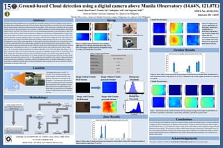
  • 1. Ground-based Cloud detection using a digital camera above Manila Observatory (14.64N, 121.07E) Gacal,GlennFranco1 ;Francis,Tan1 ;Antioquia,Carlo1 ;andLagrosas,Nofel1,2 1 Ateneode ManilaUniversity,KatipunanAve., QuezonCityPhilippines 2 ManilaObservatory,AteneodeManilaUniversitycampus,KatipunanAve.,QuezonCityPhilippines Cloud detection during nighttime poses a real problem to researchers because of a lack of optimum sensors that can specifically detect clouds during this time of the day. Hence, lidars and satellites are currently some of the instruments that are being utilized to determine cloud presence in the atmosphere. These clouds play a significant role in the night weather system for the reason that they serve as barriers of thermal radiation from the Earth and thereby reflecting this radiation back to the Earth. This effectively lowers the rate of decreasing temperature in the atmosphere at night. The objective of this study is to detect cloud occurrences at nighttime for the purpose of studying patterns of cloud occur- rence and the effects of clouds on local weather. In this study, a commercial camera (Canon Powershot A2300) is op- erated continuously to capture nighttime clouds. The camera is situated inside a weather-proof box with a glass cover and is placed on the rooftop of the Manila Observatory building to gather pictures of the sky every 5min to observe cloud dynamics and evolution in the atmosphere. To detect pixels with clouds, the pictures are converted from its na- tive JPEG to grayscale format. The pixels are then screened for clouds by looking at the values of pixels with and without clouds. In grayscale format, pixels with clouds have greater pixel values than pixels without clouds. Based on the observations, a threshold pixel value of 17 is enough to discern pixels with clouds from pixels without clouds. Figs. 1a & 1b are sample unprocessed pictures of cloudless night (May 22-23, 2014) and cloudy skies (May 23-24, 2014), respectively. Figs.1c and 1d show percentage of occurrence of nighttime clouds on May 22-23 and May 23-24, 2014, respectively. The cloud occurrence in a pixel is defined as the ratio of the number times when the pixel has clouds to the total number of observations. Fig. 1c shows less than 50% cloud occurrence while Fig. 1d shows cloud occurrence more than what is shown in Fig. 1c. These graphs show the capability of the camera to detect and measure the cloud occurrence at nighttime. Continuous collection of nighttime pictures is currently implemented. In regions where there is a dearth of scientific data, the measured nighttime cloud occurrence will serve as a baseline for future cloud studies in this part of the world. Methodology: Location Capture images of the sky above Manila Observatory at 5 minute interval. Algorithm converts one night worth of pictures from its native RGB to greyscale format. Pixel value > 17 Count as Cloud The Manila Observatory (14.6367° N, 121.0767° E) is a private non-stock, non- profit, scientific research institution estab- lished in 1865 by the Jesuit mission in the Philippines. The Observatory finds itself at the nexus of global concerns for environment and development. With its tradition of excel- lence and service in scientific research, the Observatory envisions itself as a vital partner in these critically global yet locally relevant concerns. Image without Clouds: RGB format Cloud Occurrence: This work has shown that nighttime clouds can be detected using a ground based digital camera. Continuous gathering of images can lead to measurements of nighttime cloud occurrence. Clouds are discerned from pixel values by apply- ing the threshold value of 17 from grayscale images. Further work is still needed to analyze nighttime images with rain droplets and moon signals. The occurrence of these variables destroy the pixel information of cloud signals. In the fu- ture, with continuous gathering of images, the cloud occurrence data at nighttime can be added and related to cloud oc- currence data at daytime to have a comprehensive idea of daily and seasonal cloud occurrence over an urban area in this part of the world. The authors would like to thank the Lloyd Berkner Fellowship Awards for the travel grant support. (Source: Google Maps) Count as Non- cloud YES NO Matrix of Cloud Occurrence Cloud Percentage Image without Clouds: grayscale format Image with Clouds: RGB format Image with Clouds: grayscale format Set-up Figure 2. Camera set-up without the cover Figure 3. Camera set-up with the cover Model Canon Powershot A2300 Picture size 640 x 480 pixels Exposure time 1 sec Focal Length 5 mm F-stop f/2.8 Color representation sRGB Table 1. Camera specifications Cloud Occurrence: Figure 1. Sample unprocessed pictures of a) cloudless night (May 22-23, 2014) b) and cloudy skies (May 23-24, 2014). Percentage of cloud occurrence of nighttime clouds on c) May 22-23 and d) May 23-24, 2014. OSPA No. A31H-3113 Abstract ID: 12245 Figure 5. Cloud percent- ages for a)06/01/2014, b) 06/02/2014, c)06/03/2014, d) 06/05/2014, e) 06/07/2014, f) 06/30/2014. Fig. 5d is an example of an almost clear sky (maximum cloud percent- age is roughly 15%). Figs. 5b and 5e are nights with high cloud occurrence. Figure 4. Mean values of cloud occurrence in percentage for selected dates of June 2014. Standard deviation of cloud occurrence range from 1% to 12%. Figure 6. Mean values of cloud occurrence in percentage for selected dates of October 2014. Standard devia- tion of cloud occurrence range from 0.1% to 7.4%. Compared to June results, nights of October are relatively less cloudy. Figure 7. Selected dates in the month of October showing cloud percentage for the nights of a)10/18/2014, b) 10/19/2014, c)10/202014, d)10/232014, e)10/25/2014, f)10/262014, g)10/30/2014, h)10/31/2014. Abstract October Results Conclusions Acknowledgements AMERICAN GEOPHYSICAL UNION (AGU) FALL MEETING 15-19 DECEMBER 2014 MOSCONE CENTER, SAN FRANCISCO, USA. AverageCloudCover(%) 100 200 300 400 500 600 50 100 150 200 250 300 350 400 450 0 10 20 30 40 50 60 70 80 90 100 AverageCloudCover(%) 100 200 300 400 500 600 50 100 150 200 250 300 350 400 450 0 10 20 30 40 50 60 70 80 90 100 AverageCloudCover(%) 100 200 300 400 500 600 50 100 150 200 250 300 350 400 450 0 10 20 30 40 50 60 70 80 90 100 AverageCloudCover(%) 100 200 300 400 500 600 50 100 150 200 250 300 350 400 450 0 10 20 30 40 50 60 70 80 90 100 AverageCloudCover(%) 100 200 300 400 500 600 50 100 150 200 250 300 350 400 450 0 10 20 30 40 50 60 70 80 90 100 AverageCloudCover(%) 100 200 300 400 500 600 50 100 150 200 250 300 350 400 450 0 10 20 30 40 50 60 70 80 90 100 AverageCloudCover(%) 100 200 300 400 500 600 50 100 150 200 250 300 350 400 450 0 10 20 30 40 50 60 70 80 90 100 AverageCloudCover(%) 100 200 300 400 500 600 50 100 150 200 250 300 350 400 450 0 10 20 30 40 50 60 70 80 90 100 AverageCloudCover(%) 100 200 300 400 500 600 50 100 150 200 250 300 350 400 450 0 10 20 30 40 50 60 70 80 90 100 AverageCloudCover(%) 100 200 300 400 500 600 50 100 150 200 250 300 350 400 450 0 10 20 30 40 50 60 70 80 90 100 AverageCloudCover(%) 100 200 300 400 500 600 50 100 150 200 250 300 350 400 450 0 10 20 30 40 50 60 70 80 90 100 AverageCloudCover(%) 100 200 300 400 500 600 50 100 150 200 250 300 350 400 450 0 10 20 30 40 50 60 70 80 90 100 AverageCloudCover(%) 100 200 300 400 500 600 50 100 150 200 250 300 350 400 450 0 10 20 30 40 50 60 70 80 90 100 AverageCloudCover(%) 100 200 300 400 500 600 50 100 150 200 250 300 350 400 450 0 10 20 30 40 50 60 70 80 90 100 0 0.5 1 1.5 2 2.5 x 10 4 Frequency Pixel Value 20 30 40 50 60 70 June Results 0 1 2 3 4 5 6 x 10 4 Pixel Value Frequency Pixel Value 10 15 20 Histogram: Threshold Histogram: Threshold