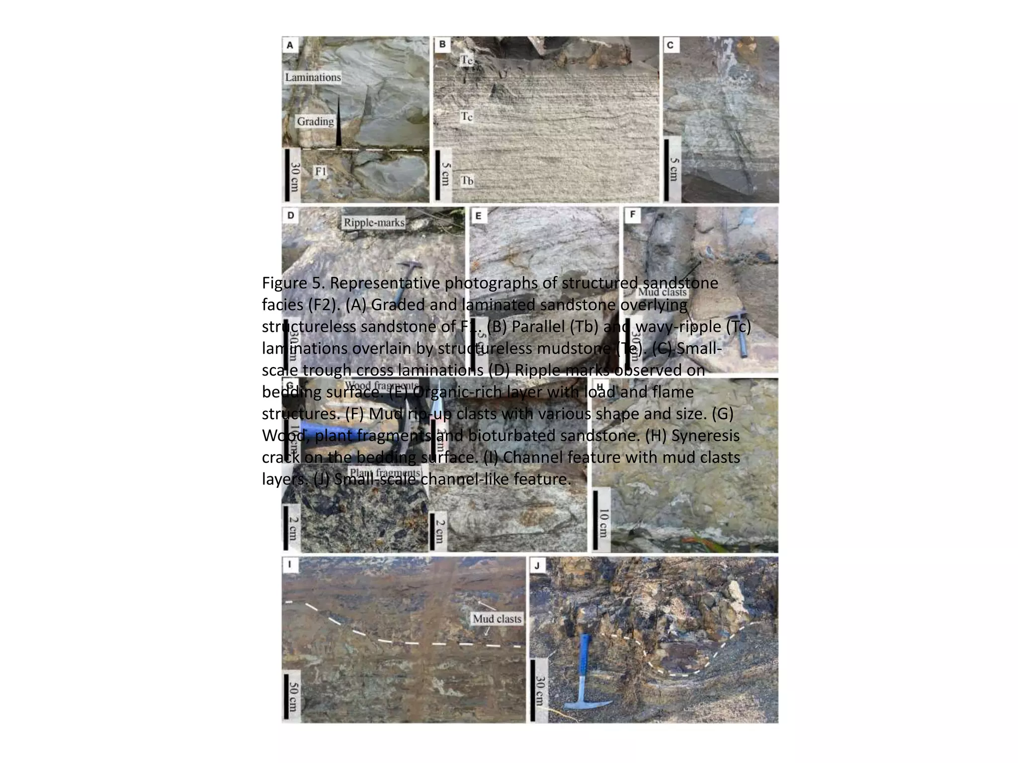
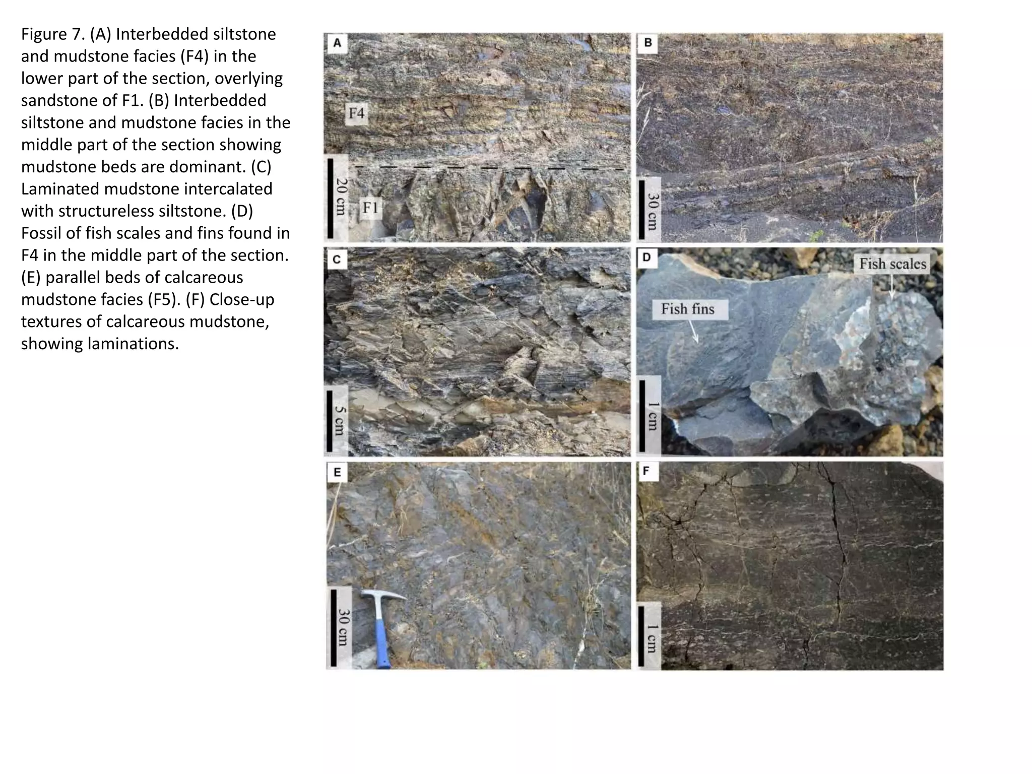
The document describes facies and depositional environments observed in an outcrop section of the Late Triassic Huai Hin Lat Formation in Thailand. Two main facies associations are identified: (1) A mudstone-dominated facies association comprised of interbedded mudstone and siltstone with occasional thin sandstone beds. (2) A sandstone-dominated facies association containing structureless, structured, and interbedded sandstone and siltstone facies. Total organic carbon values range from 0.02 to 0.99% weight, indicating poor to fair source rock potential. Outcrop gamma-ray logs aid in correlating lithofacies to depositional environments and identifying organic-rich intervals in the
The Wadi Sikait Complex:
A Fertile- Post-Collisionl Granite-Pegmatite Suite, Eastern Desert, Egypt.
The Pan-African, Wadi Sikait Complex (WSC), in the south Eastern Desert of Egypt, is a late-tectonic, subsolvus strongly peraluminous, S-type, post-collisionl granite in the Sikait area that features an unambiguous genetic linkage with a proximal, zoned cluster of Be-, REE- and Nb-Ta bearing pegmatites (Abu Rusheid and Nugrus-Sikait area). The WSC is an arcuate belt of orthogneisses, migmatites and other high-grade metamorphic rocks, which mark the boundary between the central Eastern and the south Eastern Deserts of Egypt. The WSC consists of seven internal units (WSC-1 to -3 and PL-1 to -4) that range from chemically primitive biotite, garnet and sillimanite granites (WSC-1 and –2) to a highly evolved, tourmaline- and muscovite- bearing pegmatite granite facies (PL-1 to –4) locally containing endogenous emerald/beryl, molybdinite and cassiterite. Salient petrochemical attributes include A/CNK molar which varies from 1.15 to 1.75, a wide range of SiO2 (68.7-76.9%), high Al2O3 (14.1-16.0%), low CaO (<2.35%) and FeOt+MgO+TiO2 (0.36-6.62%), and with increasing fractionation, enrichment of Na2O, K2O, B, F, Be, Rb, Ga and Li, and depletion of Ba, Sr, Zr, REE and LREE. Strong fractionation is also revealed by Al/Ga (1370-6789), Ba/Rb (<0.01-12), Ca/Sr (21-201), K/Ba (19-9545), Mg/Li (4.26-1421), Na2O/K2O (0.21-34), (Ce/Yb)CN (0.89-83.25), and Eu/Eu* (<0.05-2.29). REE distribution patterns of rare-element pegmatites are lower in REE contents and flatter with prominent negative Eu anomaly than those of the related granites. The REE concentration and the (Ce/Yb)CN ratio decrease from the WSC-1 and -2 through PL-1 and -2 (fine-grained leucogranite) and PL-3 (pegmatitic leucogranite) to the PL-4 (potassic pegmatites).
Genesis of the strongly peraluminous, S-type granite and the associated rare-element pegmatite in the Sikait-Nugrus area is explained by a complex interplay of petrogenetic processes. Rare-elements and boron were previously concentrated in (wackes and mudstone) pelitic sediments deposited in large basins. These rocks underwent step-wise rock dehydration reactions involving muscovite and biotite, under fluid-absent conditions, and successively released these elements to anatectic melt. Rare-elements and volatiles were progressively concentrated via crystal-melt fractionation, the Harker trends of which were obscured by two stages of extraction of residual melt and by episodic, subsolidus redistribution via base-cation leaching. The late magmatic history of the WSC is marked by widespread exsolution of a volatile-rich phase, dispersion of a rare-element- F-B-Be-rich fluid along shear zones and ensuing emigration of rare-element-rich melt-fluid systems upward from the cupola, which led to the regionally zoned Sikait-Nugrus area
Lithofacies and palaeoenvironmental reconstruction new microsoft office word ...DrRalimonglaYaden
In the present investigation, an attempt has been made to elucidate the sedimentary facies and depositional environment of tertiary succession of Changki valley comprising of Barail Group, Changki Formation and Tipam Sandstone Formation.
Geochemistry and Tectonic Setting of Cretaceous Sediments from Al Bauga Area,...IJRES Journal
Geochemistry; major and trace elements of Al Bauga sediments have been investigated to understand their provenance and tectonic setting. The tectonic discriminant diagrams placed the majority of Al Bauga sediments within the passive margin setting. These sediments generally, are enrich in SiO2 and depleted in K2O and Na2O. The discriminant function diagram of major elements, the enrichment of Zr, Th, La and lack of V, Co and Ni indicate that the source area of most of Al Bauga sediments are felsic provenance.
Evidence of Geological Control on Reservoir Petrophysical Properties of “Beta...Premier Publishers
Geological controls on the reservoir petrophysical properties of “BETA Field” have been carried out using suites of wireline logs. Stratigraphic relationship among the reservoir sand bodies including their geometrical architectures, and their stacking patterns were also established. Exponential regression analysis of some of the petrophysical parameters were carried out to establish any relationship with depositional processes as well as depositional environments of the reservoir sand bodies in the field. The main factor controlling petrophysical properties and thickness for these reservoirs is the type of sandstone facies. The petrophysical evaluation of both reservoirs (K and Q) depicts porosity range from fair to very good across wells (i.e 11% to 25%). From the evaluated reservoirs porosity, there is no significant reduction of porosity with depth increase. The values obtained for the permeability of both reservoirs (K and Q) varied widely and inconsistent across the wells in the study field. The various depositional environments established in BETA field include fluvial, tidal channel, mouth bars, delta front, and the reservoir sands occurring in different depositional settings, resulting from different depositional processes, which had a wide range of petrophysical properties.
Journal Petroleum Geology. Northern and Central North Sea Aptian sands, lowstand systems tract. Sequence stratigraphy development, Logs and micropapaeontology. prospectivity
Lithofacies Analysis and Petroleum Potentials of Parts of Ikom-Mamfe Embaymen...Premier Publishers
An integrated study involving detailed lithofacies analysis and source rock evaluation were carried out to reconstruct the paleoenvironment and assess the petroleum potentials of the Ikom–Mamfe embayment, southeastern Nigeria. Sedimentological field mapping involving detailed description of lithologic characteristics and facies characterisation was carried out. Geochemical studies were carried out to determine the quantity of organic matter total organic carbon (TOC), soluble organic matter (SOM), the organic matter quality (organic matter type) and level of maturity. Results show that the dominant vertical succession of the various lithofacies indicate a general finning upward succession with basal massive pebbly sandstone, medium to coarse grained sandstones with intercalation of shale and mudstones. Seven lithofacies A to G, were identified. These include: conglomerates, massive pebbly sandstone, trough cross-bedded sandstone, planar cross-bedded sandstone, shale/mudstone facies. These facies were compared with established standard facies association for determining paleoenvironment of deposition. The facies analysis carried out pointed to fluvial (alluvial – braided) depositional system as the environment of deposition. TOC values range from 0.05 – 4.13 wt% indicating poor to excellent and SOM range from 200 – 6000 ppm indicating also poor to excellent. The amount of pyrolizable carbon derived as S1 and S2 peaks suggested that the source rocks possess organic matter capable of generating hydrocarbons. Hydrogen and oxygen indices (HI and OI) ranged from 0.24 to 656 and 0.53 to 61.90 mg/gTOC respectively. Analyses of the evaluated source rock shows that the hydrocarbon potential of the study area is lean and typically of a reworked terrestrial deposit of fluvial depositional system.
Geological and Geochemical Characterization of the Neoproterozoic Derudieb Me...Premier Publishers
The meta- volcano - sedimentary sequences in the northern part of the Red Sea Hills comprise a sequence of metamorphosed rocks at low green schist facies of metamorphism consisting of lava flows, tuffs to breccias and agglomerates range in composition from basalts and andesites to rhyolites. Geologically the meta volcano sedimentary sequences is divided into metavolcanic rocks and metasediments. The metavolcanic rocks range in composition from mafic to felsic. The metasediments are represented by banded schist, quartzite and marble. The samples collected for study lie within the field of sub-alkaline rocks except one mafic volcanic sample, which plot near the boundary in the alkaline field and thus follow a transitional tholeiitic to calc-alkaline trend (increasing FeO* relative to MgO). The behavior of the large ion lithophile element (LILE) in the studied metavolcanics confirms the early fractionation of plagioclase. These rocks display negative Nb anomalies, suggesting that the melt source was modified by subduction-related fluids. Tectonically all felsic samples fall in the field of volcanic arc granitoids whereas the mafic units plot firmly within the plate margin field.
Integrated ERT and Magnetic Surveys in a Mineralization Zone in Erkowit - Red...IJERA Editor
The present study focus on integrated geophysical surveys carried out in the mineralization zone in Erkowit region, Eastern Sudan to determine the extensions of the potential ore deposits on the topographically high hilly area and under the cover of alluvium along the nearby wadi and to locate other occurrences if any. The magnetic method (MAG) and the electrical resistivity tomography (ERT) were employed for the survey. Eleven traverses were aligned approximately at right angles to the general strike of the rock formations. The disseminated sulfides are located on the alteration shear zone which is composed of granitic and dioritic highly ferruginated rock occupying the southwestern and central parts of the area, this was confirmed using thin and polished sections mineralogical analysis. The magnetic data indicates low magnetic values for wadi sedimentary deposits in its southern part of the area, and high anomalies which are suspected as gossans due to magnetite formed during wall rock alteration consequent to mineralization. The significant ERT imagesdefinelow resistivity zone as traced as sheared zones which may associated with the main loci of ore deposition. The study designates that correlation of magnetic and ERT anomalies with lithology are extremely useful in mineral exploration due to variations in some specific physical properties of rocks.
Delineation of Hydrocarbon Bearing Reservoirs from Surface Seismic and Well L...IOSR Journals
Hydrocarbon reservoir has been delineated and their boundaries mapped using direct indicators from 3-D seismic and well log data from an oil field in Nembe creek, Niger Delta region. Well log signatures were employed to identify hydrocarbon bearing sands. Well to seismic correlation revealed that these reservoirs tied with direct hydrocarbon indicators on the seismic section. The results of the interpreted well logs revealed that the hydrocarbon interval in the area occurs between 6450ft to 6533ft for well A, 6449ft to 6537ft for well B and 6629ft to 6704ft for well C; which were delineated using the resistivity, water saturation and gamma ray logs. Cross plot analysis was carried out to validate the sensitivity of the rock attributes to reservoir saturation condition. Analysis of the extracted seismic attribute slices revealed HD5000 as hydrocarbon bearing reservoir.
Using recycled concrete aggregates (RCA) for pavements is crucial to achieving sustainability. Implementing RCA for new pavement can minimize carbon footprint, conserve natural resources, reduce harmful emissions, and lower life cycle costs. Compared to natural aggregate (NA), RCA pavement has fewer comprehensive studies and sustainability assessments.
HEAP SORT ILLUSTRATED WITH HEAPIFY, BUILD HEAP FOR DYNAMIC ARRAYS.
Heap sort is a comparison-based sorting technique based on Binary Heap data structure. It is similar to the selection sort where we first find the minimum element and place the minimum element at the beginning. Repeat the same process for the remaining elements.
NO1 Uk best vashikaran specialist in delhi vashikaran baba near me online vas...Amil Baba Dawood bangali
Contact with Dawood Bhai Just call on +92322-6382012 and we'll help you. We'll solve all your problems within 12 to 24 hours and with 101% guarantee and with astrology systematic. If you want to take any personal or professional advice then also you can call us on +92322-6382012 , ONLINE LOVE PROBLEM & Other all types of Daily Life Problem's.Then CALL or WHATSAPP us on +92322-6382012 and Get all these problems solutions here by Amil Baba DAWOOD BANGALI
#vashikaranspecialist #astrologer #palmistry #amliyaat #taweez #manpasandshadi #horoscope #spiritual #lovelife #lovespell #marriagespell#aamilbabainpakistan #amilbabainkarachi #powerfullblackmagicspell #kalajadumantarspecialist #realamilbaba #AmilbabainPakistan #astrologerincanada #astrologerindubai #lovespellsmaster #kalajaduspecialist #lovespellsthatwork #aamilbabainlahore#blackmagicformarriage #aamilbaba #kalajadu #kalailam #taweez #wazifaexpert #jadumantar #vashikaranspecialist #astrologer #palmistry #amliyaat #taweez #manpasandshadi #horoscope #spiritual #lovelife #lovespell #marriagespell#aamilbabainpakistan #amilbabainkarachi #powerfullblackmagicspell #kalajadumantarspecialist #realamilbaba #AmilbabainPakistan #astrologerincanada #astrologerindubai #lovespellsmaster #kalajaduspecialist #lovespellsthatwork #aamilbabainlahore #blackmagicforlove #blackmagicformarriage #aamilbaba #kalajadu #kalailam #taweez #wazifaexpert #jadumantar #vashikaranspecialist #astrologer #palmistry #amliyaat #taweez #manpasandshadi #horoscope #spiritual #lovelife #lovespell #marriagespell#aamilbabainpakistan #amilbabainkarachi #powerfullblackmagicspell #kalajadumantarspecialist #realamilbaba #AmilbabainPakistan #astrologerincanada #astrologerindubai #lovespellsmaster #kalajaduspecialist #lovespellsthatwork #aamilbabainlahore #Amilbabainuk #amilbabainspain #amilbabaindubai #Amilbabainnorway #amilbabainkrachi #amilbabainlahore #amilbabaingujranwalan #amilbabainislamabad
Final project report on grocery store management system..pdfKamal Acharya
In today’s fast-changing business environment, it’s extremely important to be able to respond to client needs in the most effective and timely manner. If your customers wish to see your business online and have instant access to your products or services.
Online Grocery Store is an e-commerce website, which retails various grocery products. This project allows viewing various products available enables registered users to purchase desired products instantly using Paytm, UPI payment processor (Instant Pay) and also can place order by using Cash on Delivery (Pay Later) option. This project provides an easy access to Administrators and Managers to view orders placed using Pay Later and Instant Pay options.
In order to develop an e-commerce website, a number of Technologies must be studied and understood. These include multi-tiered architecture, server and client-side scripting techniques, implementation technologies, programming language (such as PHP, HTML, CSS, JavaScript) and MySQL relational databases. This is a project with the objective to develop a basic website where a consumer is provided with a shopping cart website and also to know about the technologies used to develop such a website.
This document will discuss each of the underlying technologies to create and implement an e- commerce website.
Student information management system project report ii.pdfKamal Acharya
Our project explains about the student management. This project mainly explains the various actions related to student details. This project shows some ease in adding, editing and deleting the student details. It also provides a less time consuming process for viewing, adding, editing and deleting the marks of the students.
An Approach to Detecting Writing Styles Based on Clustering Techniquesambekarshweta25
An Approach to Detecting Writing Styles Based on Clustering Techniques
Authors:
-Devkinandan Jagtap
-Shweta Ambekar
-Harshit Singh
-Nakul Sharma (Assistant Professor)
Institution:
VIIT Pune, India
Abstract:
This paper proposes a system to differentiate between human-generated and AI-generated texts using stylometric analysis. The system analyzes text files and classifies writing styles by employing various clustering algorithms, such as k-means, k-means++, hierarchical, and DBSCAN. The effectiveness of these algorithms is measured using silhouette scores. The system successfully identifies distinct writing styles within documents, demonstrating its potential for plagiarism detection.
Introduction:
Stylometry, the study of linguistic and structural features in texts, is used for tasks like plagiarism detection, genre separation, and author verification. This paper leverages stylometric analysis to identify different writing styles and improve plagiarism detection methods.
Methodology:
The system includes data collection, preprocessing, feature extraction, dimensional reduction, machine learning models for clustering, and performance comparison using silhouette scores. Feature extraction focuses on lexical features, vocabulary richness, and readability scores. The study uses a small dataset of texts from various authors and employs algorithms like k-means, k-means++, hierarchical clustering, and DBSCAN for clustering.
Results:
Experiments show that the system effectively identifies writing styles, with silhouette scores indicating reasonable to strong clustering when k=2. As the number of clusters increases, the silhouette scores decrease, indicating a drop in accuracy. K-means and k-means++ perform similarly, while hierarchical clustering is less optimized.
Conclusion and Future Work:
The system works well for distinguishing writing styles with two clusters but becomes less accurate as the number of clusters increases. Future research could focus on adding more parameters and optimizing the methodology to improve accuracy with higher cluster values. This system can enhance existing plagiarism detection tools, especially in academic settings.
Hybrid optimization of pumped hydro system and solar- Engr. Abdul-Azeez.pdffxintegritypublishin
Advancements in technology unveil a myriad of electrical and electronic breakthroughs geared towards efficiently harnessing limited resources to meet human energy demands. The optimization of hybrid solar PV panels and pumped hydro energy supply systems plays a pivotal role in utilizing natural resources effectively. This initiative not only benefits humanity but also fosters environmental sustainability. The study investigated the design optimization of these hybrid systems, focusing on understanding solar radiation patterns, identifying geographical influences on solar radiation, formulating a mathematical model for system optimization, and determining the optimal configuration of PV panels and pumped hydro storage. Through a comparative analysis approach and eight weeks of data collection, the study addressed key research questions related to solar radiation patterns and optimal system design. The findings highlighted regions with heightened solar radiation levels, showcasing substantial potential for power generation and emphasizing the system's efficiency. Optimizing system design significantly boosted power generation, promoted renewable energy utilization, and enhanced energy storage capacity. The study underscored the benefits of optimizing hybrid solar PV panels and pumped hydro energy supply systems for sustainable energy usage. Optimizing the design of solar PV panels and pumped hydro energy supply systems as examined across diverse climatic conditions in a developing country, not only enhances power generation but also improves the integration of renewable energy sources and boosts energy storage capacities, particularly beneficial for less economically prosperous regions. Additionally, the study provides valuable insights for advancing energy research in economically viable areas. Recommendations included conducting site-specific assessments, utilizing advanced modeling tools, implementing regular maintenance protocols, and enhancing communication among system components.
We have compiled the most important slides from each speaker's presentation. This year’s compilation, available for free, captures the key insights and contributions shared during the DfMAy 2024 conference.
Saudi Arabia stands as a titan in the global energy landscape, renowned for its abundant oil and gas resources. It's the largest exporter of petroleum and holds some of the world's most significant reserves. Let's delve into the top 10 oil and gas projects shaping Saudi Arabia's energy future in 2024.
Literature Review Basics and Understanding Reference Management.pptxDr Ramhari Poudyal
Three-day training on academic research focuses on analytical tools at United Technical College, supported by the University Grant Commission, Nepal. 24-26 May 2024
Online aptitude test management system project report.pdfKamal Acharya
The purpose of on-line aptitude test system is to take online test in an efficient manner and no time wasting for checking the paper. The main objective of on-line aptitude test system is to efficiently evaluate the candidate thoroughly through a fully automated system that not only saves lot of time but also gives fast results. For students they give papers according to their convenience and time and there is no need of using extra thing like paper, pen etc. This can be used in educational institutions as well as in corporate world. Can be used anywhere any time as it is a web based application (user Location doesn’t matter). No restriction that examiner has to be present when the candidate takes the test.
Every time when lecturers/professors need to conduct examinations they have to sit down think about the questions and then create a whole new set of questions for each and every exam. In some cases the professor may want to give an open book online exam that is the student can take the exam any time anywhere, but the student might have to answer the questions in a limited time period. The professor may want to change the sequence of questions for every student. The problem that a student has is whenever a date for the exam is declared the student has to take it and there is no way he can take it at some other time. This project will create an interface for the examiner to create and store questions in a repository. It will also create an interface for the student to take examinations at his convenience and the questions and/or exams may be timed. Thereby creating an application which can be used by examiners and examinee’s simultaneously.
Examination System is very useful for Teachers/Professors. As in the teaching profession, you are responsible for writing question papers. In the conventional method, you write the question paper on paper, keep question papers separate from answers and all this information you have to keep in a locker to avoid unauthorized access. Using the Examination System you can create a question paper and everything will be written to a single exam file in encrypted format. You can set the General and Administrator password to avoid unauthorized access to your question paper. Every time you start the examination, the program shuffles all the questions and selects them randomly from the database, which reduces the chances of memorizing the questions.
Cosmetic shop management system project report.pdfKamal Acharya
Buying new cosmetic products is difficult. It can even be scary for those who have sensitive skin and are prone to skin trouble. The information needed to alleviate this problem is on the back of each product, but it's thought to interpret those ingredient lists unless you have a background in chemistry.
Instead of buying and hoping for the best, we can use data science to help us predict which products may be good fits for us. It includes various function programs to do the above mentioned tasks.
Data file handling has been effectively used in the program.
The automated cosmetic shop management system should deal with the automation of general workflow and administration process of the shop. The main processes of the system focus on customer's request where the system is able to search the most appropriate products and deliver it to the customers. It should help the employees to quickly identify the list of cosmetic product that have reached the minimum quantity and also keep a track of expired date for each cosmetic product. It should help the employees to find the rack number in which the product is placed.It is also Faster and more efficient way.
Forklift Classes Overview by Intella PartsIntella Parts
Discover the different forklift classes and their specific applications. Learn how to choose the right forklift for your needs to ensure safety, efficiency, and compliance in your operations.
For more technical information, visit our website https://intellaparts.com
1. Facies and Facies Models
Facies and Facies Models
What is a facies?
A sedimentary unit with consistent characteristics (lithology, grain size, texture, structures, etc.) that formed under specific depositional conditions.
What are facies models?
An idealized vertical succession of facies that would be expected from the migration of depositional environments within a particular setting (e.g., sandy braided river model, wave-dominated delta model).
2
Walthers Law
Rationale for interpreting vertical facies succession is based on Walthers Law
Vertical succession of facies represents migration of laterally adjacent depositional environments, unless there is evidence of erosion (unconformity)
3
Constructing a facies model:
Identify important surfaces (especially erosional)
4
Constructing a facies model:
Interpret facies using knowledge of sedimentary processes and modern environments
5
Constructing a facies model:
Determine characteristic vertical succession of facies
6
2. AMALGAMATED SANDS
facies 4: channel shape and/or
differential compaction with
moderate or high amplitudes
inferred geological facies:
amalgamated channel sands
• 1 map = 1 facies class
• Combine maps
Mechanics
Horizons
__ top Balder
__ top Sele
__ top Forties
E
A
Am
pli
tud
e
B C D
Facies code
__ facies 1 (shale)
__ facies 2 (overbanks)
__ facies 3 (sheet sands)
__ facies 4 (amalgamated)
Seismic facies map
~2km
amalgamated
sands
sheet sands
overbank
deposits
shale-prone
Meanwhile…
Facies
• Inheritance:
– sand, shaley sand, heterolithics, shale, cement
3. Introduction
Identification and reconstruction of depositional environments are important in petroleum exploration and development as they provide the
necessary framework for delineation and prediction of petroleum system components in the basin, especially in frontier exploration areas. Source
rock is one of primary concerned elements for petroleum potential evaluation and the occurrence of source rock is controlled by the depositional
environments (Magoon and Dow, 1994; Law, 1999). Source rock and depositional environment assessments are typically based on geochemical
analyses which can provide both quantitative and qualitative aspects of source rocks (Tissot and Welte, 1984; Peters and Cassa, 1994). However, in
order to perform the geochemical analyses, rock samples are required. Thus, there is a limitation in the use of geochemical analyses to examine and
evaluate petroleum source rocks in the frontier or immature explorations due to insubstantial or no subsurface samples.
Geophysical approaches such as seismic and well log interpretations have been widely used in petroleum exploration. It can be used to fulfill the gap
of the geochemical analyses to investigate depositional environments as well as to assess petroleum source rocks in subsurface, particularly in frontier
basins with limited availability of subsurface samples such as cutting, sidewall core, conventional core. Gamma-ray logs are a fundamental tool which
is commonly used for lithological identification and stratigraphic correlation in subsurface (Myers and Wignall, 1987; Slatt et al., 1992; Rider, 1996).
Gamma-ray logs measure the total γ-emission called total gamma-ray logs and differentiated contributions of potassium (K), uranium (U) and thorium
(Th) called spectral gamma-ray logs. The patterns and shapes of gamma-ray logs can assist in facies analysis and interpretation of depositional
environments (Selley, 1978; Cant, 1992; Rider, 1996; Nazeer et al., 2016). Moreover, gamma-ray logs and other wireline logs can be utilized to
evaluate petroleum source rocks (e.g., Myers and Wignall, 1987; Passey et al., 1990; Lüning and Kolonic, 2003) and estimate total organic carbon (TOC)
contents by using the gamma-ray and TOC linear relationship (e.g., Schmoker, 1981; Fertl and Chilingar, 1988; Huang et al., 2015; Aziz et al., 2020).
Several investigations provided a relationship between gamma-ray logs, both total and spectral, and organic-rich intervals (e.g., Myers and Wignall,
1987; Lüning et al., 2000, 2004; Lüning and Kolonic, 2003; Correia et al., 2012; Gómez et al., 2016; Sêco et al., 2018). In general, total gamma-ray
responses are closely related to fine-grained clay-rich sediments (shale, clay stone, mudstone). The organic matter preservation usually increases
within these fine-grained sediments under an anoxic condition. Thus, high gamma-ray responses have been a valuable tool used to correlate a
petroleum source rock. However, to evaluate petroleum source rock, the gamma-ray responses should be used with caution as it is dominantly
influenced by mineral compositions (Myers and Wignall, 1987; Rider, 1996). Spectral gamma ray logs provide more information on the identification
of organic-rich intervals, especially the U response (Myers and Wignall, 1987; Lüning and Kolonic, 2003). Outcrop gamma-ray log has been
investigated for many years as it is useful for documenting changes in strata patterns, stratigraphic correlations and sequence stratigraphic
interpretations (Myers and Bristow, 1989; Slatt et al., 1992; Davies and Elliott, 1996; Evans et al., 2007). It also provides a link between lithological
features observed in outcrop and subsurface which improves the understanding of the subsurface data (Slatt et al., 1992, 1995; Aigner et al., 1995).
The Khorat basin located in northeastern Thailand covers much of the Indochina block and is believed to have complex tectonic activity during the late
Paleozoic and Mesozoic (Minezaki et al., 2019). This basin has been explored for petroleum potential since 1962 and two commercial petroleum fields
have been discovered since 1988 (Racey, 2011). The Late Triassic Huai Hin Lat Formation is believed to be one of petroleum source rocks in the Khorat
basin (Booth, 1998). Due to the thick Mesozoic strata overlain the Huai Hin Lat Formation (Figure 1A), full drilling cores covered this formation are
limited (Racey, 2011). Geochemical analyses on petroleum potential source rock of the Huai Hin Lat Formation are confirmed to have a good to
excellent source rock (Racey, 2011). However, the lithology and depositional environments of this formation varies from place to place within the
Khorat basin. Thus, outcrop gamma-ray log can be used to constrain the well log interpretation of this formation in the subsurface.
4. Figure 1. (A) Stratigraphy of the Khorat plateau including
petroleum system elements and key events (modified from Racey,
2011). The red box highlights the Huia Hin Lat interval which is the
studied Formation. (B) The classified member of the Huai Hin Lat
Formation (Chonglakmani and Sattayarak, 1978).
The study area in the Phetchabun Province, situated in the
western edge of the Khorat plateau, provides well exposed
outcrop of the Huai Hin Lat Formation and can be used as an
outcrop analog to enhance the understanding of the Huai Hin Lat
Formation in the subsurface. This study highlights the first use of
outcrop gamma-ray log investigation in Thailand along with
detailed outcrop descriptions, facies analysis, the total organic
carbon (TOC) analysis, aiming to identify and reconstruct the
deposition environment of the study area. The results are useful
for petroleum exploration and recognizing the organic-rich
intervals. This contribution can also help in dealing with local and
regional correlations of the Triassic anoxic events, especially within
the Indochina block.
5.
6.
7. Figure 8. The lithology log of the studied section
correlate with total and spectral gamma-ray logs
composed of potassium (K), thorium (Th), uranium
(U), U/Th ratios including the TOC abundance from
the representative samples throughout the section.
Facies association boundaries are presented in dash
line. Two major coarsening upward cycles (large
arrows) and several minor trends (small arrows) of the
sections can be observed mainly from total gamma-
ray log in correlation with the sedimentary facies from
stratigraphic log. The abundances of clay minerals
including chlorite, mica, illite and montmorillonite
from mudstone samples are also included to provide
the correlation with the other logs in the section
8. Figure 5. Representative photographs of structured sandstone
facies (F2). (A) Graded and laminated sandstone overlying
structureless sandstone of F1. (B) Parallel (Tb) and wavy-ripple (Tc)
laminations overlain by structureless mudstone (Te). (C) Small-
scale trough cross laminations (D) Ripple marks observed on
bedding surface. (E) Organic-rich layer with load and flame
structures. (F) Mud rip-up clasts with various shape and size. (G)
Wood, plant fragments and bioturbated sandstone. (H) Syneresis
crack on the bedding surface. (I) Channel feature with mud clasts
layers. (J) Small-scale channel-like feature.
9. Figure 6. (A) Interbedded sandstone and siltstone facies (F3). (B)
Small scale planar and through cross-laminations in sandstone bed
of F3.
10. Figure 7. (A) Interbedded siltstone
and mudstone facies (F4) in the
lower part of the section, overlying
sandstone of F1. (B) Interbedded
siltstone and mudstone facies in the
middle part of the section showing
mudstone beds are dominant. (C)
Laminated mudstone intercalated
with structureless siltstone. (D)
Fossil of fish scales and fins found in
F4 in the middle part of the section.
(E) parallel beds of calcareous
mudstone facies (F5). (F) Close-up
textures of calcareous mudstone,
showing laminations.
11. Table 1. Summary of sedimentary facies from the studied section.
13. Facies Association 1 (FA1): Mudstone-Dominated Facies Association
Facies association 1 (FA1) consists mainly of fine-grained sedimentary facies including interbedded mudstone and siltstone facies
(F4), calcareous mudstone facies (F5), and occasional thin bedded structureless sandstone facies (F1) (Table 2). The FA 1 occurs in
two main parts of the measured section; the lower part from 0 to 14.7 m and the middle part from 37.5 to 45.3 m. The lower part
is dominated by F4 with a short interval of F5 and a thin bed of F1 at the base of this facies association. Fossils and trace fossils are
rarely observed in the lower part. The frequency of siltstone beds intercalated with the mudstone in this part is higher than those
in the middle part (Figures 7A,B). The middle part mainly comprises F4 with mudstone dominant. The FA1 is bounded by an
erosional surface at the top of the facies association which changes into sandstone-dominated facies association.
Facies Association 2 (FA2): Sandstone-Dominated Facies Association
Facies association 2 (FA2) composes of structureless sandstone facies (F1), structured sandstone facies (F2) and interbedded
sandstone and siltstone facies (F3) (Table 2). This facies association is encountered from 14.7 to 37.6 m in the lower part of the
measured section and from 45.3 to 72.8 m in the upper part of the measured section overlying the FA1. The structureless
sandstone facies (F1) is more dominant in the lower part and often presented as amalgamated beds (Figure 3). The structured
sandstone facies (F2) is the main component of this facies association, especially in the upper part (Figure 3). The structureless
sandstone beds are often overlain by parallel laminated sandstone and gradually change into wavy to ripple laminations with
occasionally topped by thin structureless siltstone or mudstone (Figures 5A,B). The interbedded sandstone and siltstone facies,
normally found on top of F1 and F2, are more abundant in the lower part than those in the upper part that occasionally appear as
short intervals (Figure 3). The wood and plant fragments including fish scales and bioturbation are locally observed throughout
the FA2.
Total Organic Carbon (TOC)
The TOC contents in this study range from 0.02 to 0.99 wt%. The lowest TOC value is recorded from sandstone and the highest
TOC value is found in mudstone. The source rock potential of samples from the section can be classified as poor (0-0.5%) to fair
(0.5-1%) based on the classification of Peters and Cassa (1994). The summary of the ranges and averages of TOC values in each
facies is presented in Table 3.