Presentation given at the “Exploring Research” - The Faculty of Law, Arts and Social Science Conference, University of Southampton, Jun 7th 2005.
Based on presentation given at CAA 2005 held in Tomar, Portugal. Presenting my PhD research to a non-archaeological, non-technical audience.
Pathways, Perception and the development of PlacePaul Cripps
Computational approaches to movement and perception of landscape in prehistory.
Building on my masters work, an initial presentation having just started my PhD
Pathways, Perception and the development of PlacePaul Cripps
Computational approaches to movement and perception of landscape in prehistory.
Building on my masters work, an initial presentation having just started my PhD
Towards a graph of ancient world geographical knowledgeElton Barker
Presentation on three collaborative projects: Hestia (http://hestia.open.ac.uk/), GAP (http://googleancientplaces.wordpress.com/gapvis/), and Pelagios (pelagios-project.blogspot.com)
Photosynths as a method for capturing rich visual, qualitative dataGavin Harper
Photosynths as a method for capturing rich visual, qualitative data
8th International Qualitative Research Conference
6-8th September
Talbot Campus
Bournemouth University
Gavin D. J. Harper
The ESRC Centre for Business Relationships, Accountability, Sustainability and Society
Cardiff University
55 Park Place
Cardiff
CF10 3AT
United Kingdom
harpergd@cf.ac.uk
Geosemantic Tools for Archaeological ResearchPaul Cripps
Presentation given at the annual Postgraduate Researchers Presentation Day held at the University of South Wales Postgraduate Research Centre, Trefforest Campus.
Linked Geospatial Data for Archaeological Research Paul Cripps
Investigating Archaeological Research Questions using a Linked Data framework
A presentation given to the Avebury & Stonehenge Archaeological & Historical Research Group, May 2015.
21st Century Geospatial #HistEnv Data ManagementPaul Cripps
A keynote presentation given at the Towards a Collaborative Strategy for sector information management (TACOS) seminar held at the University of York, May 2014
GeoSemantic Technologies for Archaeological ResourcesPaul Cripps
The semantics of heritage data is a growing area of interest with ontologies such as the CIDOC-CRM providing semantic frameworks and exemplary projects such as STAR and STELLAR demonstrating what can be done using semantic technologies applied to archaeological resources. In the world of the Semantic Web, advances regarding geosemantics have emerged to extend research more fully into the spatio-temporal domain, for example extending the SPARQL standard to produce GeoSPARQL. Importantly, the use of semantic technologies, particularly the structure of RDF, aligns with graph and network based approaches, providing a rich fusion of techniques for geospatial analysis of heritage data expressed in such a manner.
This paper gives an overview of the ongoing G-STAR research project (GeoSemantic Technologies for Archaeological Resources) with reference to broader sectoral links particularly to commercial archaeology. Particular attention is paid to examining the integration of spatial data into the heritage Global Graph and the relationship between Spatial Data Infrastructure (SDI) and Linked Data, moving beyond notions of ‘location’ as simple nodes, placenames and coordinates towards fuller support for complex geometries and advanced spatial reasoning. Finally, the potential impacts of such research is discussed with particular reference to the current practice of commercial archaeology, access to and publishing of (legacy, big) data, and leveraging network models to better understand and manage change within archaeological information systems.
A University Technical College for Wiltshire; Specialising in Science and En...Paul Cripps
A presentation given by Clive Duggleby (General Manager, Tetricus Science Park) to Salisbury Cafe Scientifique, November 2012
See the Cafe Scientifique website for more information:
http://cafescientifiquesalisbury.org.uk/2012/11/wiltshire-utc/
Archaeological Computing Research Group (ACRG) Seminar: Digital Spatial Techn...Paul Cripps
Digital Spatial Technologies have become central to modern archaeological practice. There are a number of interrelated strands to this which can be broadly categorised as capture, management, analysis/interpretation, visualisation and dissemination.
Techniques and technologies used to capture spatial data include: Total Station Theodolites (TST), Terrestrial Laser Scanners (TLS), Airborne Laser Scanners (ALS) and Global Navigation Satellite Systems (GNSS); computational photography including Reflectance Transformation Imaging (RTI), Structure from Motion (SfM) and photogrammetry.
Allied with this are tools and techniques to support management, analysis, visualisation and dissemination including more robust, ontologically driven, semantically enabled data models and Archaeological Information Systems (AIS) to handle both spatial and spatially referenced digital data and all manner of visualisations and interfaces (2D, 3D, graphs, web, portals, etc) for resource discovery, analysis and dissemination.
Digital resources are being made accessible like never before, with spatiality forming a key component, opening up new potential with platforms such as Google Earth and Spatial Data Infrastructures (SDI) for research, public access and heritage management either here, now, or becoming possible, drawing on and breathing new life into archaeological archives and indices.
All of this combines to help us as archaeologists create richer, multi-vocal, data driven narratives and theoretical frameworks and ultimately better understand the past and convey this to a wider audience. Drawing on experiences from one of the UKs largest archaeological units as well as ongoing projects across the heritage domain in which I have participated or observed, this talk aims to give a personal view on where we as a discipline are at and some ideas for where we can go next.
More Related Content
Similar to Pathways, Perception and the development of Place; Computational approaches to movement and perception of landscape in prehistory
Towards a graph of ancient world geographical knowledgeElton Barker
Presentation on three collaborative projects: Hestia (http://hestia.open.ac.uk/), GAP (http://googleancientplaces.wordpress.com/gapvis/), and Pelagios (pelagios-project.blogspot.com)
Photosynths as a method for capturing rich visual, qualitative dataGavin Harper
Photosynths as a method for capturing rich visual, qualitative data
8th International Qualitative Research Conference
6-8th September
Talbot Campus
Bournemouth University
Gavin D. J. Harper
The ESRC Centre for Business Relationships, Accountability, Sustainability and Society
Cardiff University
55 Park Place
Cardiff
CF10 3AT
United Kingdom
harpergd@cf.ac.uk
Geosemantic Tools for Archaeological ResearchPaul Cripps
Presentation given at the annual Postgraduate Researchers Presentation Day held at the University of South Wales Postgraduate Research Centre, Trefforest Campus.
Linked Geospatial Data for Archaeological Research Paul Cripps
Investigating Archaeological Research Questions using a Linked Data framework
A presentation given to the Avebury & Stonehenge Archaeological & Historical Research Group, May 2015.
21st Century Geospatial #HistEnv Data ManagementPaul Cripps
A keynote presentation given at the Towards a Collaborative Strategy for sector information management (TACOS) seminar held at the University of York, May 2014
GeoSemantic Technologies for Archaeological ResourcesPaul Cripps
The semantics of heritage data is a growing area of interest with ontologies such as the CIDOC-CRM providing semantic frameworks and exemplary projects such as STAR and STELLAR demonstrating what can be done using semantic technologies applied to archaeological resources. In the world of the Semantic Web, advances regarding geosemantics have emerged to extend research more fully into the spatio-temporal domain, for example extending the SPARQL standard to produce GeoSPARQL. Importantly, the use of semantic technologies, particularly the structure of RDF, aligns with graph and network based approaches, providing a rich fusion of techniques for geospatial analysis of heritage data expressed in such a manner.
This paper gives an overview of the ongoing G-STAR research project (GeoSemantic Technologies for Archaeological Resources) with reference to broader sectoral links particularly to commercial archaeology. Particular attention is paid to examining the integration of spatial data into the heritage Global Graph and the relationship between Spatial Data Infrastructure (SDI) and Linked Data, moving beyond notions of ‘location’ as simple nodes, placenames and coordinates towards fuller support for complex geometries and advanced spatial reasoning. Finally, the potential impacts of such research is discussed with particular reference to the current practice of commercial archaeology, access to and publishing of (legacy, big) data, and leveraging network models to better understand and manage change within archaeological information systems.
A University Technical College for Wiltshire; Specialising in Science and En...Paul Cripps
A presentation given by Clive Duggleby (General Manager, Tetricus Science Park) to Salisbury Cafe Scientifique, November 2012
See the Cafe Scientifique website for more information:
http://cafescientifiquesalisbury.org.uk/2012/11/wiltshire-utc/
Archaeological Computing Research Group (ACRG) Seminar: Digital Spatial Techn...Paul Cripps
Digital Spatial Technologies have become central to modern archaeological practice. There are a number of interrelated strands to this which can be broadly categorised as capture, management, analysis/interpretation, visualisation and dissemination.
Techniques and technologies used to capture spatial data include: Total Station Theodolites (TST), Terrestrial Laser Scanners (TLS), Airborne Laser Scanners (ALS) and Global Navigation Satellite Systems (GNSS); computational photography including Reflectance Transformation Imaging (RTI), Structure from Motion (SfM) and photogrammetry.
Allied with this are tools and techniques to support management, analysis, visualisation and dissemination including more robust, ontologically driven, semantically enabled data models and Archaeological Information Systems (AIS) to handle both spatial and spatially referenced digital data and all manner of visualisations and interfaces (2D, 3D, graphs, web, portals, etc) for resource discovery, analysis and dissemination.
Digital resources are being made accessible like never before, with spatiality forming a key component, opening up new potential with platforms such as Google Earth and Spatial Data Infrastructures (SDI) for research, public access and heritage management either here, now, or becoming possible, drawing on and breathing new life into archaeological archives and indices.
All of this combines to help us as archaeologists create richer, multi-vocal, data driven narratives and theoretical frameworks and ultimately better understand the past and convey this to a wider audience. Drawing on experiences from one of the UKs largest archaeological units as well as ongoing projects across the heritage domain in which I have participated or observed, this talk aims to give a personal view on where we as a discipline are at and some ideas for where we can go next.
Presentation given at the Computer Applications in Archaeology UK Chapter Meeting, April 2011, held at the University of Birmingham.
The subject is the use of terrestrial and airborne laser scanners in heritage contexts.
Survey in the new millennium: Tools for the 21st century archaeologistPaul Cripps
A talk given at Digital Past: New Technologies in Heritage, Interpretation and Outreach. RCHMW Seminar. A seminar organised to guide heritage managers, education and outreach officers, and museum and local government officers in Wales and further
afield through some of the newest technologies available for researching and promoting heritage sites. This was done through the medium of papers presented by key speakers who talked through practical examples where such technologies have been used, what their problems and experiences may have been and the practical outcomes for communities or heritage managers
To OO or not to OO? Revelations from defining an ontology for an archaeologic...Paul Cripps
A presentation given by Keith May and me at CAA 2004 held in Prato, Italy. The topic was a sub-project which emerged from the English Heritage Revelation project; the Ontological Modelling project. This project looked at a range of existing data models, paper forms, databases and other source information and through discussions with domain specialists, created a representation of the information archaeologists use based on the CIDOC Conceptual Reference Model (CRM).
Public Access through technology; Using archaeological computing to interact ...Paul Cripps
A presentation given at Strode College for students from the University of Plymouth, Truro College and Strode College , aimed at given them an overview on how technology is used to engage with the public using examples from Wessex Archaeology and other sources
Of Henges, Rock Art & Lasers; An application of Laser-Scanning techniques at ...Paul Cripps
A presentation given in May 2005 at the McDonald Institute for Archaeological Research, University of Cambridge, on behalf of the Stonehenge Laser Scan project team. The presentation was aimed at highlighting some of the results and well as the technologies used.
Thinking in bits; archaeological theory and computing, past, present and future.Paul Cripps
A presentation given at TAG 2008 at University of Southampton on the subject of the changing nature of archaeological computing and its relationship with archaeological theory and the broader discipline of archaeology
GDG Cloud Southlake #33: Boule & Rebala: Effective AppSec in SDLC using Deplo...James Anderson
Effective Application Security in Software Delivery lifecycle using Deployment Firewall and DBOM
The modern software delivery process (or the CI/CD process) includes many tools, distributed teams, open-source code, and cloud platforms. Constant focus on speed to release software to market, along with the traditional slow and manual security checks has caused gaps in continuous security as an important piece in the software supply chain. Today organizations feel more susceptible to external and internal cyber threats due to the vast attack surface in their applications supply chain and the lack of end-to-end governance and risk management.
The software team must secure its software delivery process to avoid vulnerability and security breaches. This needs to be achieved with existing tool chains and without extensive rework of the delivery processes. This talk will present strategies and techniques for providing visibility into the true risk of the existing vulnerabilities, preventing the introduction of security issues in the software, resolving vulnerabilities in production environments quickly, and capturing the deployment bill of materials (DBOM).
Speakers:
Bob Boule
Robert Boule is a technology enthusiast with PASSION for technology and making things work along with a knack for helping others understand how things work. He comes with around 20 years of solution engineering experience in application security, software continuous delivery, and SaaS platforms. He is known for his dynamic presentations in CI/CD and application security integrated in software delivery lifecycle.
Gopinath Rebala
Gopinath Rebala is the CTO of OpsMx, where he has overall responsibility for the machine learning and data processing architectures for Secure Software Delivery. Gopi also has a strong connection with our customers, leading design and architecture for strategic implementations. Gopi is a frequent speaker and well-known leader in continuous delivery and integrating security into software delivery.
Epistemic Interaction - tuning interfaces to provide information for AI supportAlan Dix
Paper presented at SYNERGY workshop at AVI 2024, Genoa, Italy. 3rd June 2024
https://alandix.com/academic/papers/synergy2024-epistemic/
As machine learning integrates deeper into human-computer interactions, the concept of epistemic interaction emerges, aiming to refine these interactions to enhance system adaptability. This approach encourages minor, intentional adjustments in user behaviour to enrich the data available for system learning. This paper introduces epistemic interaction within the context of human-system communication, illustrating how deliberate interaction design can improve system understanding and adaptation. Through concrete examples, we demonstrate the potential of epistemic interaction to significantly advance human-computer interaction by leveraging intuitive human communication strategies to inform system design and functionality, offering a novel pathway for enriching user-system engagements.
Alt. GDG Cloud Southlake #33: Boule & Rebala: Effective AppSec in SDLC using ...James Anderson
Effective Application Security in Software Delivery lifecycle using Deployment Firewall and DBOM
The modern software delivery process (or the CI/CD process) includes many tools, distributed teams, open-source code, and cloud platforms. Constant focus on speed to release software to market, along with the traditional slow and manual security checks has caused gaps in continuous security as an important piece in the software supply chain. Today organizations feel more susceptible to external and internal cyber threats due to the vast attack surface in their applications supply chain and the lack of end-to-end governance and risk management.
The software team must secure its software delivery process to avoid vulnerability and security breaches. This needs to be achieved with existing tool chains and without extensive rework of the delivery processes. This talk will present strategies and techniques for providing visibility into the true risk of the existing vulnerabilities, preventing the introduction of security issues in the software, resolving vulnerabilities in production environments quickly, and capturing the deployment bill of materials (DBOM).
Speakers:
Bob Boule
Robert Boule is a technology enthusiast with PASSION for technology and making things work along with a knack for helping others understand how things work. He comes with around 20 years of solution engineering experience in application security, software continuous delivery, and SaaS platforms. He is known for his dynamic presentations in CI/CD and application security integrated in software delivery lifecycle.
Gopinath Rebala
Gopinath Rebala is the CTO of OpsMx, where he has overall responsibility for the machine learning and data processing architectures for Secure Software Delivery. Gopi also has a strong connection with our customers, leading design and architecture for strategic implementations. Gopi is a frequent speaker and well-known leader in continuous delivery and integrating security into software delivery.
In his public lecture, Christian Timmerer provides insights into the fascinating history of video streaming, starting from its humble beginnings before YouTube to the groundbreaking technologies that now dominate platforms like Netflix and ORF ON. Timmerer also presents provocative contributions of his own that have significantly influenced the industry. He concludes by looking at future challenges and invites the audience to join in a discussion.
zkStudyClub - Reef: Fast Succinct Non-Interactive Zero-Knowledge Regex ProofsAlex Pruden
This paper presents Reef, a system for generating publicly verifiable succinct non-interactive zero-knowledge proofs that a committed document matches or does not match a regular expression. We describe applications such as proving the strength of passwords, the provenance of email despite redactions, the validity of oblivious DNS queries, and the existence of mutations in DNA. Reef supports the Perl Compatible Regular Expression syntax, including wildcards, alternation, ranges, capture groups, Kleene star, negations, and lookarounds. Reef introduces a new type of automata, Skipping Alternating Finite Automata (SAFA), that skips irrelevant parts of a document when producing proofs without undermining soundness, and instantiates SAFA with a lookup argument. Our experimental evaluation confirms that Reef can generate proofs for documents with 32M characters; the proofs are small and cheap to verify (under a second).
Paper: https://eprint.iacr.org/2023/1886
SAP Sapphire 2024 - ASUG301 building better apps with SAP Fiori.pdfPeter Spielvogel
Building better applications for business users with SAP Fiori.
• What is SAP Fiori and why it matters to you
• How a better user experience drives measurable business benefits
• How to get started with SAP Fiori today
• How SAP Fiori elements accelerates application development
• How SAP Build Code includes SAP Fiori tools and other generative artificial intelligence capabilities
• How SAP Fiori paves the way for using AI in SAP apps
UiPath Test Automation using UiPath Test Suite series, part 4DianaGray10
Welcome to UiPath Test Automation using UiPath Test Suite series part 4. In this session, we will cover Test Manager overview along with SAP heatmap.
The UiPath Test Manager overview with SAP heatmap webinar offers a concise yet comprehensive exploration of the role of a Test Manager within SAP environments, coupled with the utilization of heatmaps for effective testing strategies.
Participants will gain insights into the responsibilities, challenges, and best practices associated with test management in SAP projects. Additionally, the webinar delves into the significance of heatmaps as a visual aid for identifying testing priorities, areas of risk, and resource allocation within SAP landscapes. Through this session, attendees can expect to enhance their understanding of test management principles while learning practical approaches to optimize testing processes in SAP environments using heatmap visualization techniques
What will you get from this session?
1. Insights into SAP testing best practices
2. Heatmap utilization for testing
3. Optimization of testing processes
4. Demo
Topics covered:
Execution from the test manager
Orchestrator execution result
Defect reporting
SAP heatmap example with demo
Speaker:
Deepak Rai, Automation Practice Lead, Boundaryless Group and UiPath MVP
Dev Dives: Train smarter, not harder – active learning and UiPath LLMs for do...UiPathCommunity
💥 Speed, accuracy, and scaling – discover the superpowers of GenAI in action with UiPath Document Understanding and Communications Mining™:
See how to accelerate model training and optimize model performance with active learning
Learn about the latest enhancements to out-of-the-box document processing – with little to no training required
Get an exclusive demo of the new family of UiPath LLMs – GenAI models specialized for processing different types of documents and messages
This is a hands-on session specifically designed for automation developers and AI enthusiasts seeking to enhance their knowledge in leveraging the latest intelligent document processing capabilities offered by UiPath.
Speakers:
👨🏫 Andras Palfi, Senior Product Manager, UiPath
👩🏫 Lenka Dulovicova, Product Program Manager, UiPath
GenAISummit 2024 May 28 Sri Ambati Keynote: AGI Belongs to The Community in O...
Pathways, Perception and the development of Place; Computational approaches to movement and perception of landscape in prehistory
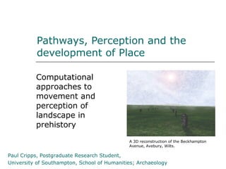
1. Pathways, Perception and the
development of Place
Computational
approaches to
movement and
perception of
landscape in
prehistory
A 3D reconstruction of the Beckhampton
Avenue, Avebury, Wilts.
Paul Cripps, Postgraduate Research Student,
University of Southampton, School of Humanities; Archaeology
2. 2 Pathways, Perception and the development of Place; Computational approaches to movement and perception of landscape in prehistory
“Exploring Research” - LASS Conference, University of Southampton, Jun 7th 2005
Outline
Introduction
Landscape studies
Visibility analysis
Abstractions of reality
Approximations of
the situation
Moving and seeing
Movement
Perception
Computer based
approaches
An integrated
approach A 3D reconstruction of the Cove in
Longstones Field, Avebury, Wilts.
Available tools; GIS
and 3D
An integrated system
3. 3 Pathways, Perception and the development of Place; Computational approaches to movement and perception of landscape in prehistory
“Exploring Research” - LASS Conference, University of Southampton, Jun 7th 2005
Background & Introduction
Any landscape can be seen as a snapshot of the
complex continuum of interaction between
humans and their environment
The formation of landscapes, particularly
significant places within them, can therefore be
seen as a function of this interaction
This interaction has at its core the notions of
movement and perception, humans being highly
visually attuned, mobile actors
In the later Neolithic, we see monumental forms
which are linear in nature and may be related to
movement of one kind or another
4. 4 Pathways, Perception and the development of Place; Computational approaches to movement and perception of landscape in prehistory
“Exploring Research” - LASS Conference, University of Southampton, Jun 7th 2005
e.g. Stonehenge, Wilts.
Many
archaeological
remains
Complex sequence
of developments
over a very long
period of time
Linear monuments
include an avenue
and two cursus
5. 5 Pathways, Perception and the development of Place; Computational approaches to movement and perception of landscape in prehistory
“Exploring Research” - LASS Conference, University of Southampton, Jun 7th 2005
Landscape studies & visibility analysis
Landscape interpretation comprises functional
aspects (eg Renfrew) and phenomenological
aspects (eg Tilley, Thomas)
Complementary rather than bipolar
Visibility analysis fuses these aspects and has
been used successfully to analyse visual
characteristics of landscape built up from the
point of view of individual human actors
eg Exon, Gaffney, Woodward & Yorston (2000);
investigated intervisibility of sites around
Stonehenge
eg Wheatley (1995); looked at intervisibility of
long barrows around Avebury and Stonehenge
eg Llobera; looked at total visual characteristics
of landscape
6. 6 Pathways, Perception and the development of Place; Computational approaches to movement and perception of landscape in prehistory
“Exploring Research” - LASS Conference, University of Southampton, Jun 7th 2005
Abstraction from reality…
Visibility analysis can only ever provide an
approximation of the situation
Better approximations can be achieved by
improving the theoretical model used and/or the
source data
Computers can be used to speed up the process
of calculating lines-of-sight; a viewshed shows all
the lines-of-sight from a location
A simple binary viewshed can be seen as a
starting point illustrating a single static view but
can also be used as the input to:
Cumulative, Fuzzy and Dynamic viewshed
techniques used to give an improved
approximation the situation
7. 7 Pathways, Perception and the development of Place; Computational approaches to movement and perception of landscape in prehistory
“Exploring Research” - LASS Conference, University of Southampton, Jun 7th 2005
Approximations of the situation
But this is still only part of the story!
Traditionally, visibility analysis dependent on a
purely mathematical approach using Line-Of-Sight
vectors
What about other factors…?
Vegetation has a dramatic effect on visibility, as
does weather, colour, relative position and
lighting
Static viewpoints only give one view, often biased
by the choice of archaeological sites as input
locations
8. 8 Pathways, Perception and the development of Place; Computational approaches to movement and perception of landscape in prehistory
“Exploring Research” - LASS Conference, University of Southampton, Jun 7th 2005
Approximations of the situation
A mathematical
approach to
visibility
Processor intensive;
powerful computers
needed
Many calculations
possible on a
modern computer
9. 9 Pathways, Perception and the development of Place; Computational approaches to movement and perception of landscape in prehistory
“Exploring Research” - LASS Conference, University of Southampton, Jun 7th 2005
Moving and seeing
So visibility analyses to date, while successful,
have for the most part, ignored effects of
movement and perception
While there may be significance in particular
static viewsheds, what about humans as dynamic
agents, moving through, seeing and interacting
with the landscape around them…?
This investigation will draw on theoretical
discourses and make use of the concept of
visibility as a means to investigate this cultural
continuum in terms of movement and perception
Hence, inferences regarding site location, relative
chronology and functional aspects may be made
10. 10 Pathways, Perception and the development of Place; Computational approaches to movement and perception of landscape in prehistory
“Exploring Research” - LASS Conference, University of Southampton, Jun 7th 2005
Perception
For the purposes of this investigation, a simplified
perceptual model is used:
Based on visibility and factors influencing visibility
alone eg effects of colour, lighting, relative
position, environmental factors, etc
Other senses (aural, haptic, etc) are currently
ignored
Drawing on interdisciplinary sources eg
psychology and landscape design
11. 11 Pathways, Perception and the development of Place; Computational approaches to movement and perception of landscape in prehistory
“Exploring Research” - LASS Conference, University of Southampton, Jun 7th 2005
Movement
Humans are dynamic agents capable of moving
and interacting with their environment
It is through such movements and interactions an
understanding of landscape is constructed
This understanding is incorporated back into the
landscape continuum by means of human action
eg constructing/destruction of monuments,
reserving ‘special’ places, cultural practices, etc
Movement is therefore an important factor in the
way humans come to understand the world
around them
12. 12 Pathways, Perception and the development of Place; Computational approaches to movement and perception of landscape in prehistory
“Exploring Research” - LASS Conference, University of Southampton, Jun 7th 2005
An integrated approach
A holistic approach needed
GIS cannot adequetely account for the factors
previously mentioned
3D technologies do not have the sort of analytical
functions found in GIS, but outputs can be
subjected to image analysis.
Therefore, make use of analytical 2D GIS and
image analysis supported and qualified by 3D
visualisation tools
Incorporate rich spatial data; terrain models,
lighting/atmospheric models, environmental
evidence, reconstructed archaeological features
and interpretations (eg Neolithic neon)
13. 13 Pathways, Perception and the development of Place; Computational approaches to movement and perception of landscape in prehistory
“Exploring Research” - LASS Conference, University of Southampton, Jun 7th 2005
GIS based Viewshed Analysis
Binary viewshed
from the Cove in
Longstones Field,
Avebury, Wilts.
Pink areas visible,
other areas not
visible
14. 14 Pathways, Perception and the development of Place; Computational approaches to movement and perception of landscape in prehistory
“Exploring Research” - LASS Conference, University of Southampton, Jun 7th 2005
GIS based Viewshed Analysis
Probabilistic
viewshed
from
Stonehenge,
Wilts.
Grey areas
not visible;
darker
shades of
blue indicate
higher
probability of
being visible
15. 15 Pathways, Perception and the development of Place; Computational approaches to movement and perception of landscape in prehistory
“Exploring Research” - LASS Conference, University of Southampton, Jun 7th 2005
GIS based Viewshed Analysis
Animated
sequence of
viewsheds along
the path of the
Beckhampton
Avenue,
Avebury Wilts.
A dynamic
approach to
viewsheds
16. 16 Pathways, Perception and the development of Place; Computational approaches to movement and perception of landscape in prehistory
“Exploring Research” - LASS Conference, University of Southampton, Jun 7th 2005
3D visualisation
Animations
Modern
computers
capable of
real-time high
quality
visualisations
Animation showing the Cove,
Longstones Field, Avebury, Wilts.
21. 21 Pathways, Perception and the development of Place; Computational approaches to movement and perception of landscape in prehistory
“Exploring Research” - LASS Conference, University of Southampton, Jun 7th 2005
An integrated system
Image Analysis
(analytical gfx package
Viewsheds Viewsheds
tbc)
(simple, (complex,
Animations Rendered binary) compound)
views
3D model 2D spatial analysis
(Vue Infinite v5) (ArcINFO / Grass)
Dynamic
interaction
(gaming
engine /
OpenGL tbc)
GIS database
(ArcINFO / Grass)
Uni-directional data flow
Bi-directional data flow
Interface interaction
22. 22 Pathways, Perception and the development of Place; Computational approaches to movement and perception of landscape in prehistory
“Exploring Research” - LASS Conference, University of Southampton, Jun 7th 2005
Next steps
This investigation is still very much work in
progress (first year PhD, studying part-time)
Hardware set up (ACRG Workstation); Unix based
(OSX; Tiger) 64-bit workstation recently acquired
System components to be integrated and tested
(due late 2005); Open-source where possible
Detailed investigations of study areas to follow
(scheduled for 2006), including fieldwork to
validate results
23. 23 Pathways, Perception and the development of Place; Computational approaches to movement and perception of landscape in prehistory
“Exploring Research” - LASS Conference, University of Southampton, Jun 7th 2005
Acknowledgements & image credits
Dr. David Wheatley (Supervisor)
English Heritage; Stonehenge & Avebury World
Heritage Site GIS (archaeological data)
Archaeological Computing Research Group (support)
http://www.arch.soton.ac.uk/Prospectus/ACRG/
Eon Software (manufacturers of Vue 5 Infinite)
http://www.e-onsoftware.com/Products/vue5infinite
ATI (manufacturers of graphics cards)
http://www.ati.com/developer/demos/macss2/
24. 24 Pathways, Perception and the development of Place; Computational approaches to movement and perception of landscape in prehistory
“Exploring Research” - LASS Conference, University of Southampton, Jun 7th 2005
fin
360° Panorama from Windmill Hill, Avebury, Wilts.
Contact paul.cripps@soton.ac.uk
See www.soton.ac.uk/~pjc196/research/
for more information
Based on a paper originally presented at
Computer Applications in Archaeology,
Tomar, Portugal, Easter 2005