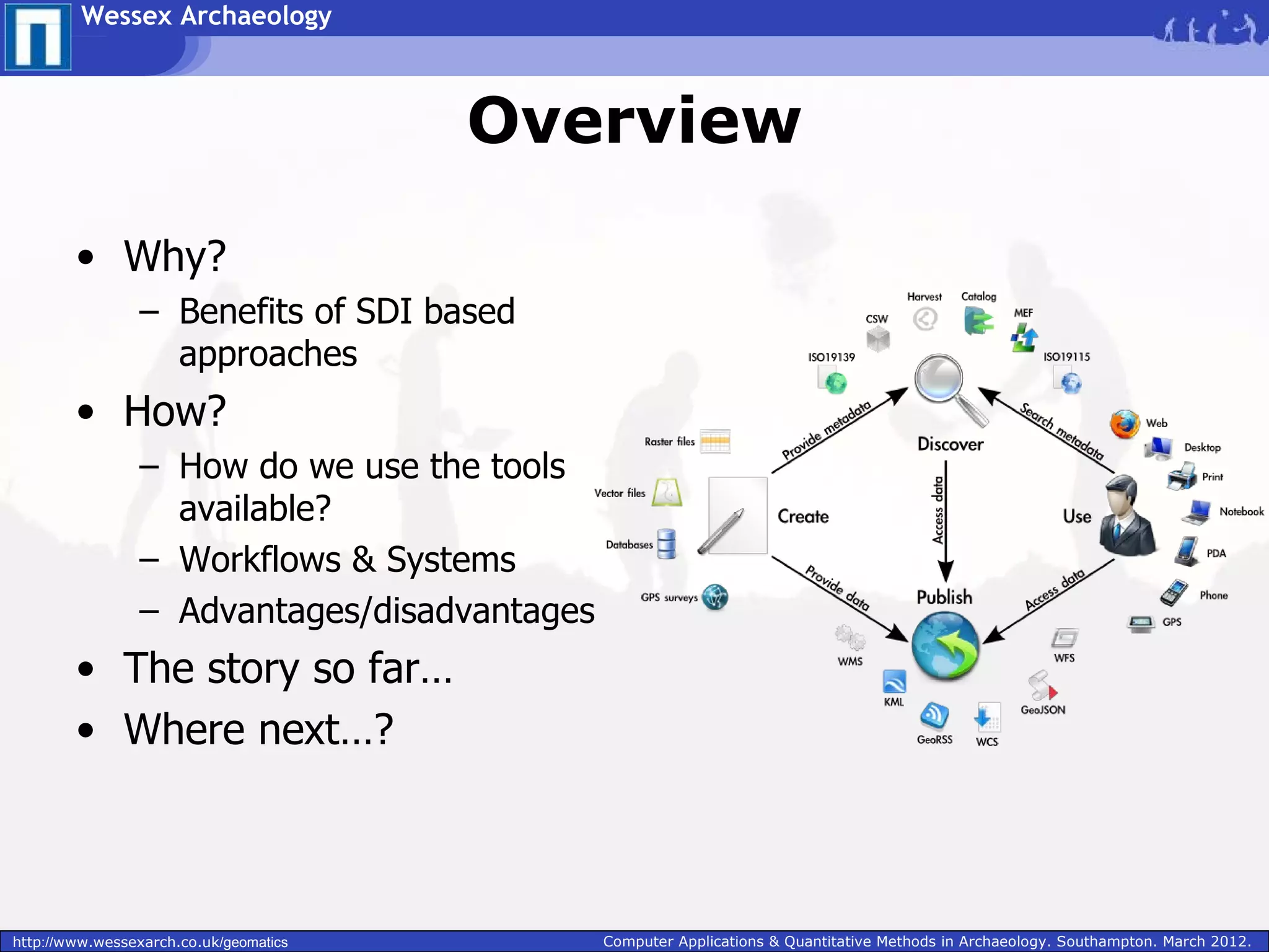
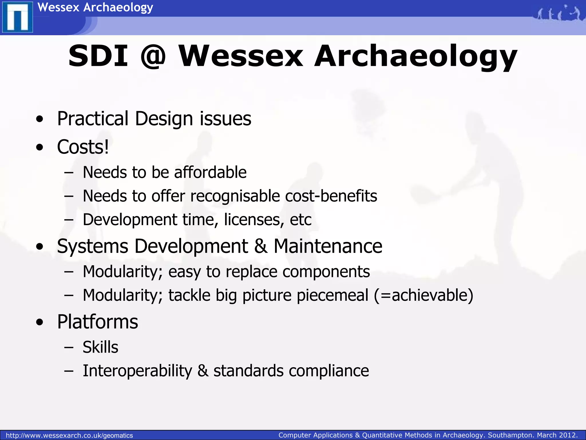
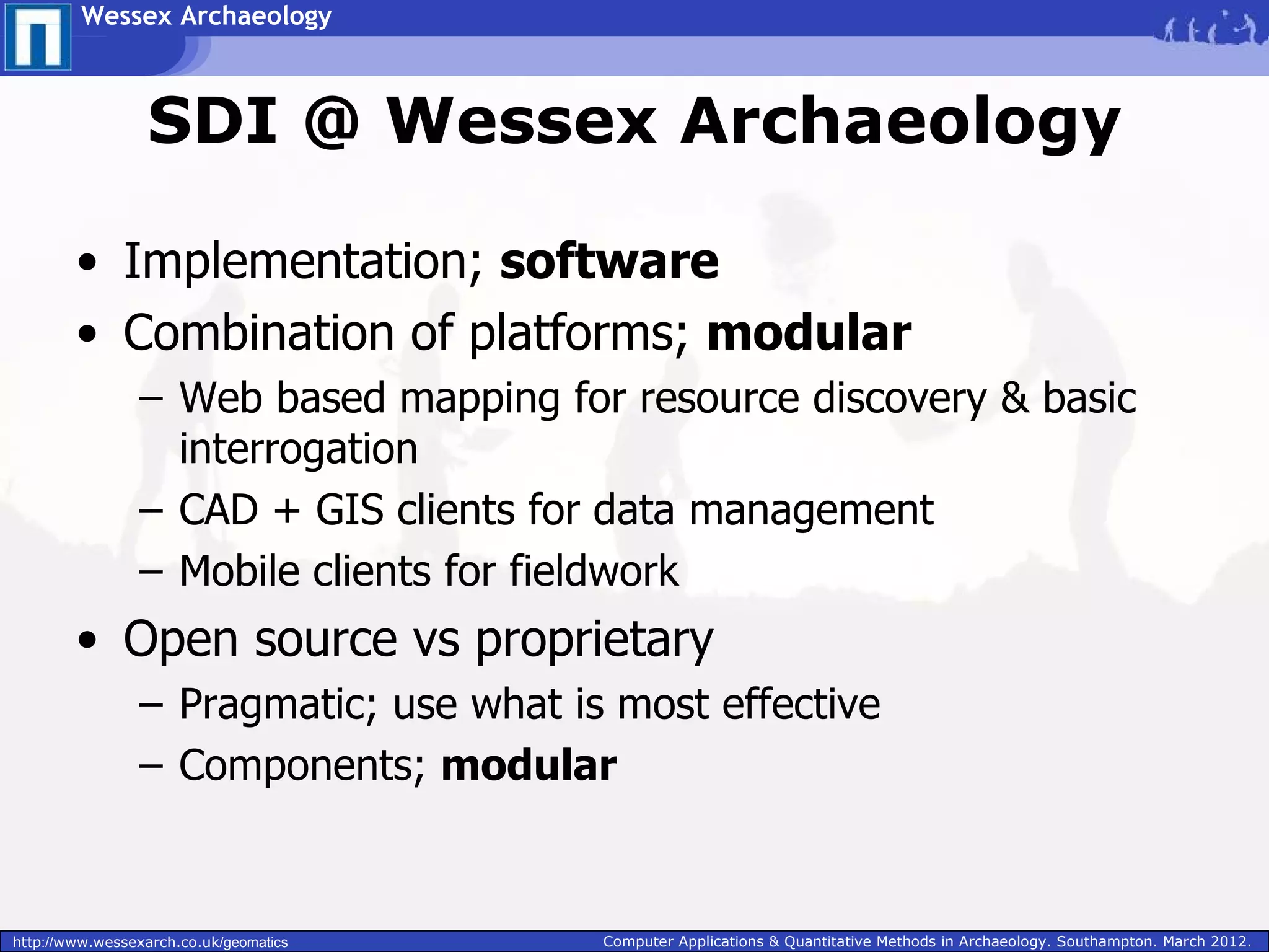
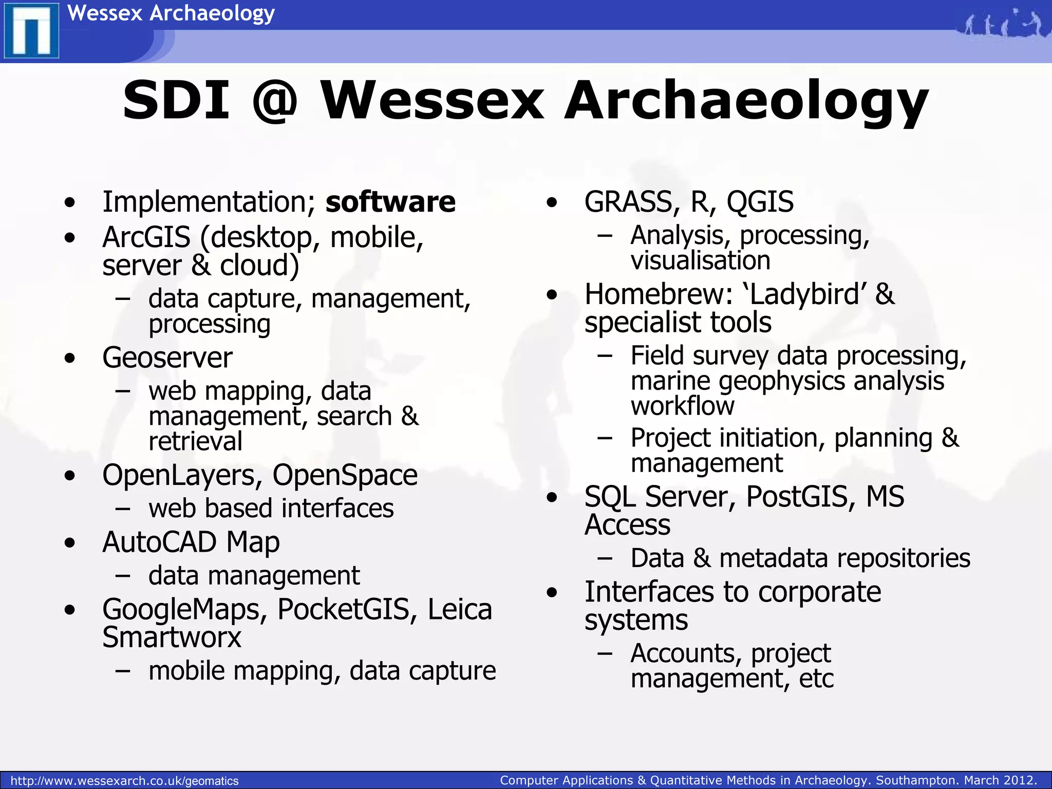
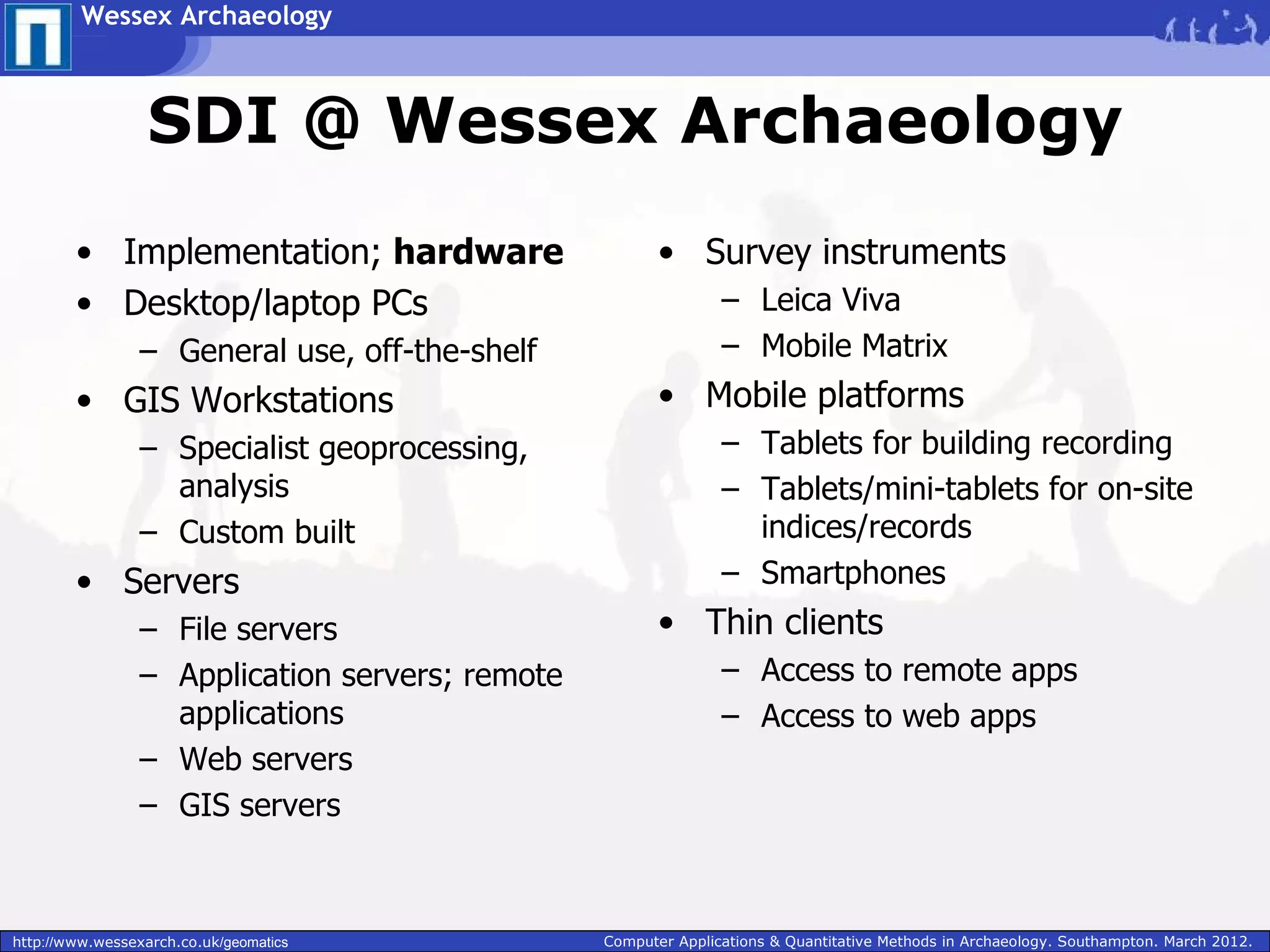
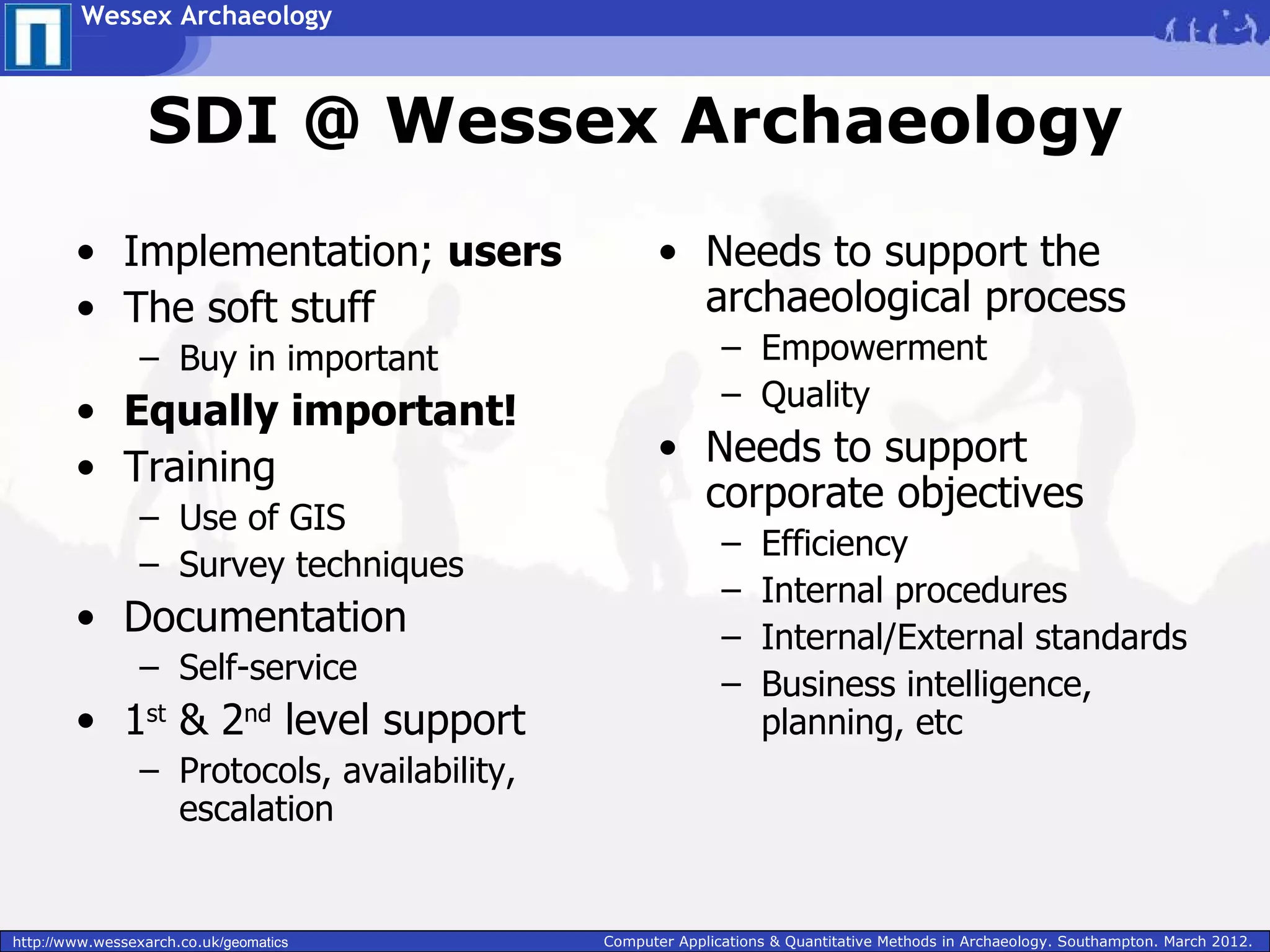
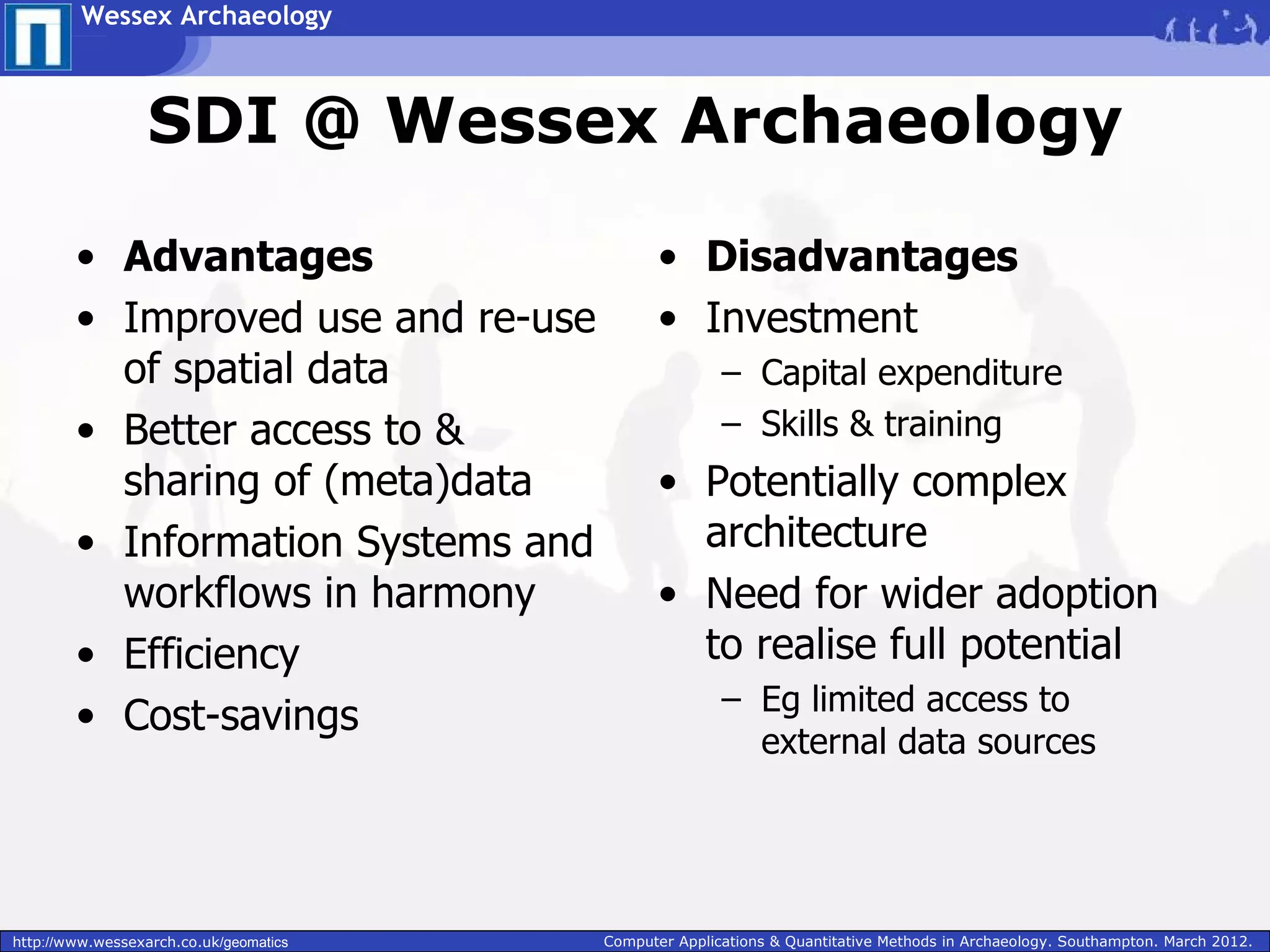
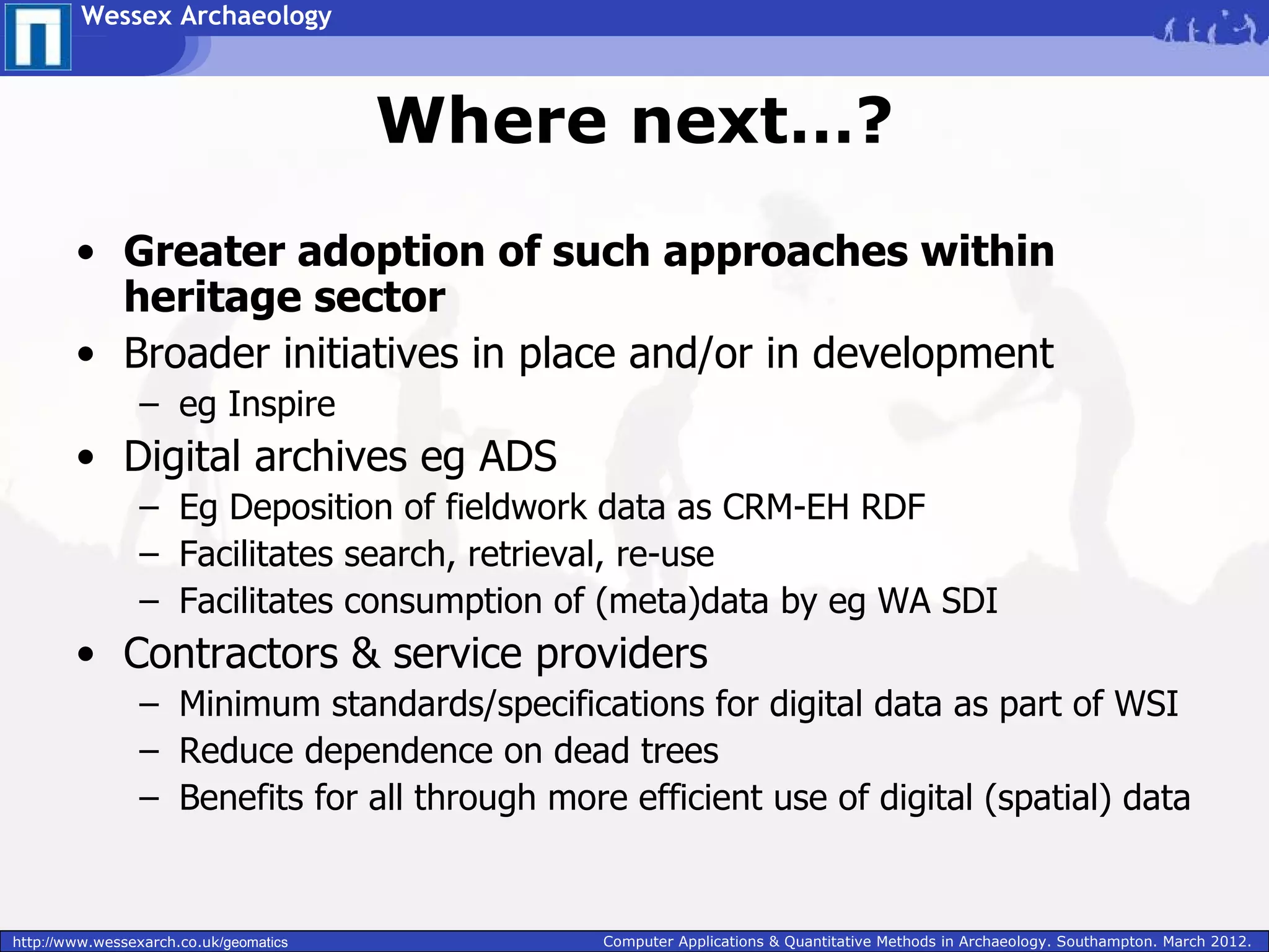
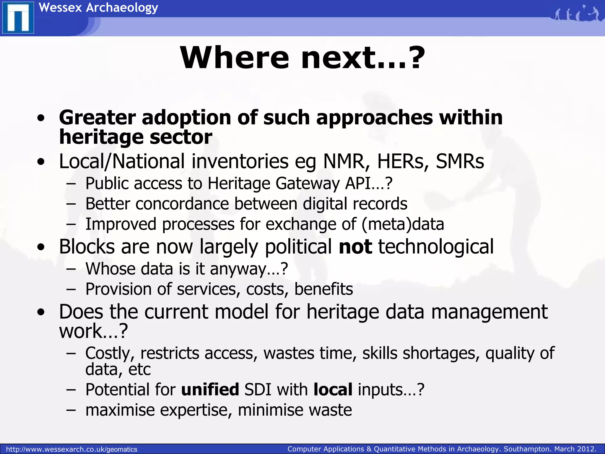
Wessex Archaeology


             SDI: A perspective from a UK
                  archaeological unit


                                        Concepts and ideas to practical
                                               implementation


Paul Cripps
•Geomatics Manager, Wessex Archaeology
•Archaeological Computing Research Group, University of Southampton

http://www.wessexarch.co.uk/geomatics                         Computer Applications & Quantitative Methods in Archaeology. Southampton. March 2012.
Wessex Archaeology


                                        Overview

        • Why?
                 – Benefits of SDI based
                   approaches
        • How?
                 – How do we use the tools
                   available?
                 – Workflows & Systems
                 – Advantages/disadvantages
        • The story so far…
        • Where next…?


http://www.wessexarch.co.uk/geomatics         Computer Applications & Quantitative Methods in Archaeology. Southampton. March 2012.
Wessex Archaeology


                                          Why…?

        • Need to manage spatial data effectively
                 –    Discovery
                 –    Retrieval
                 –    Use & re-use
                 –    Publication & Dissemination
        • Bulk of archaeological data is spatial or can be spatially
          referenced
        • Improvements in
                 – Quality
                 – Accessibility (internal & external)
                 – Efficiency


http://www.wessexarch.co.uk/geomatics           Computer Applications & Quantitative Methods in Archaeology. Southampton. March 2012.
Wessex Archaeology


                                        Current context
        • Disparate resources, silos, disjointed data management
                 – Wastes time/money
                 – duplicated effort
        • Need for efficiency
                 – Cost savings
                 – Improved workflows
                 – Frees up time to focus on what matters
        • Change Management @ Wessex Archaeology
                 – Satellite offices
                 – Process Modelling
                 – Integration
        • Aim: Improved, effective business processes
                 – Data flows; is enhanced, reused, shared, published, archived
        • Can use GIS/SDI based approaches to help achieve this

http://www.wessexarch.co.uk/geomatics         Computer Applications & Quantitative Methods in Archaeology. Southampton. March 2012.
Wessex Archaeology


                                        What is SDI?
        • A Spatial Data Infrastructure is a framework of
          geographic data, metadata, users and tools that
          are interactively connected in order to use spatial data in
          an efficient and flexible way
        • The technologies, policies, standards, human
          resources, and related activities necessary to create,
          acquire, process, distribute, use, maintain, and
          preserve spatial data
        • a coordinated series of agreements on technology
          standards, institutional arrangements, and
          policies that enable the discovery and use of
          geospatial information by users and for purposes other
          than those it was created for

http://www.wessexarch.co.uk/geomatics        Computer Applications & Quantitative Methods in Archaeology. Southampton. March 2012.
Wessex Archaeology


                                        What is SDI?

        • software client(s) - to display, query, and analyse
          spatial data (eg Desktop/web GIS, CAD)
        • a catalogue service - for the discovery, browsing, and
          querying of metadata or spatial services, spatial datasets
          and other resources
        • spatial data webservices - allowing the delivery of
          data via the Internet to disparate clients / platforms
        • processing services - such as datum and projection
          transformations
        • a (spatial) data repository - to store data
        • GIS software - to create and update spatial data

http://www.wessexarch.co.uk/geomatics        Computer Applications & Quantitative Methods in Archaeology. Southampton. March 2012.
Wessex Archaeology


                  SDI @ Wessex Archaeology

        • Design:
                 – Theoretical issues
                 – Practical issues
        • Implementation
                 –    Software
                 –    Hardware
                 –    Users
                 –    Protocols, policies, procedures, training


http://www.wessexarch.co.uk/geomatics        Computer Applications & Quantitative Methods in Archaeology. Southampton. March 2012.
Wessex Archaeology


                  SDI @ Wessex Archaeology
        • Theoretical Design issues
        • Needs to support the archaeological process
                 – Multi-vocality
                 – Assertion & inference, evidential trails
                 – Revision, version control & iterative thought processes
        • Discovery & consumption of external data
                 – WMS/WFS easy, but needs to reference particular version of any
                   data
        • Provision of data externally
                 – Linked Open Data
        • User interactions
                 – Must be positive!
                 – Easy to use; help & support not additional drain on resources


http://www.wessexarch.co.uk/geomatics         Computer Applications & Quantitative Methods in Archaeology. Southampton. March 2012.
Wessex Archaeology


                  SDI @ Wessex Archaeology

        • Practical Design issues
        • Costs!
                 – Needs to be affordable
                 – Needs to offer recognisable cost-benefits
                 – Development time, licenses, etc
        • Systems Development & Maintenance
                 – Modularity; easy to replace components
                 – Modularity; tackle big picture piecemeal (=achievable)
        • Platforms
                 – Skills
                 – Interoperability & standards compliance


http://www.wessexarch.co.uk/geomatics         Computer Applications & Quantitative Methods in Archaeology. Southampton. March 2012.
Wessex Archaeology


                  SDI @ Wessex Archaeology

        • Implementation; software
        • Combination of platforms; modular
                 – Web based mapping for resource discovery & basic
                   interrogation
                 – CAD + GIS clients for data management
                 – Mobile clients for fieldwork
        • Open source vs proprietary
                 – Pragmatic; use what is most effective
                 – Components; modular


http://www.wessexarch.co.uk/geomatics    Computer Applications & Quantitative Methods in Archaeology. Southampton. March 2012.
Wessex Archaeology


                  SDI @ Wessex Archaeology
        • Implementation; software                       • GRASS, R, QGIS
        • ArcGIS (desktop, mobile,                               – Analysis, processing,
          server & cloud)                                          visualisation
                 – data capture, management,             • Homebrew: ‘Ladybird’ &
                   processing                              specialist tools
        • Geoserver                                              – Field survey data processing,
                 – web mapping, data                               marine geophysics analysis
                   management, search &                            workflow
                   retrieval                                     – Project initiation, planning &
        • OpenLayers, OpenSpace                                    management
                 – web based interfaces                  • SQL Server, PostGIS, MS
                                                           Access
        • AutoCAD Map
                                                                 – Data & metadata repositories
                 – data management
                                                         • Interfaces to corporate
        • GoogleMaps, PocketGIS, Leica                     systems
          Smartworx
                                                                 – Accounts, project
                 – mobile mapping, data capture                    management, etc


http://www.wessexarch.co.uk/geomatics             Computer Applications & Quantitative Methods in Archaeology. Southampton. March 2012.
Wessex Archaeology


                  SDI @ Wessex Archaeology
        • Implementation; hardware                      • Survey instruments
        • Desktop/laptop PCs                                    – Leica Viva
                 – General use, off-the-shelf                   – Mobile Matrix
        • GIS Workstations                              • Mobile platforms
                 – Specialist geoprocessing,                    – Tablets for building recording
                   analysis                                     – Tablets/mini-tablets for on-site
                 – Custom built                                   indices/records
        • Servers                                               – Smartphones
                 – File servers                         • Thin clients
                 – Application servers; remote                  – Access to remote apps
                   applications                                 – Access to web apps
                 – Web servers
                 – GIS servers


http://www.wessexarch.co.uk/geomatics            Computer Applications & Quantitative Methods in Archaeology. Southampton. March 2012.
Wessex Archaeology


                  SDI @ Wessex Archaeology
        • Implementation; users                      • Needs to support the
        • The soft stuff                               archaeological process
                 – Buy in important                          – Empowerment
                                                             – Quality
        • Equally important!
        • Training                                   • Needs to support
                                                       corporate objectives
                 – Use of GIS
                                                             –    Efficiency
                 – Survey techniques
                                                             –    Internal procedures
        • Documentation                                      –    Internal/External standards
                 – Self-service                              –    Business intelligence,
        • 1st & 2nd level support                                 planning, etc
                 – Protocols, availability,
                   escalation


http://www.wessexarch.co.uk/geomatics         Computer Applications & Quantitative Methods in Archaeology. Southampton. March 2012.
Wessex Archaeology


                  SDI @ Wessex Archaeology

        • Advantages                           • Disadvantages
        • Improved use and re-use              • Investment
          of spatial data                              – Capital expenditure
        • Better access to &                           – Skills & training
          sharing of (meta)data                • Potentially complex
        • Information Systems and                architecture
          workflows in harmony                 • Need for wider adoption
        • Efficiency                             to realise full potential
                                                       – Eg limited access to
        • Cost-savings
                                                         external data sources


http://www.wessexarch.co.uk/geomatics   Computer Applications & Quantitative Methods in Archaeology. Southampton. March 2012.
Wessex Archaeology


                                        Where next…?
        • Greater adoption of such approaches within
          heritage sector
        • Broader initiatives in place and/or in development
                 – eg Inspire
        • Digital archives eg ADS
                 – Eg Deposition of fieldwork data as CRM-EH RDF
                 – Facilitates search, retrieval, re-use
                 – Facilitates consumption of (meta)data by eg WA SDI
        • Contractors & service providers
                 – Minimum standards/specifications for digital data as part of WSI
                 – Reduce dependence on dead trees
                 – Benefits for all through more efficient use of digital (spatial) data


http://www.wessexarch.co.uk/geomatics           Computer Applications & Quantitative Methods in Archaeology. Southampton. March 2012.
Wessex Archaeology


                                        Where next…?
        • Greater adoption of such approaches within
          heritage sector
        • Local/National inventories eg NMR, HERs, SMRs
                 – Public access to Heritage Gateway API…?
                 – Better concordance between digital records
                 – Improved processes for exchange of (meta)data
        • Blocks are now largely political not technological
                 – Whose data is it anyway…?
                 – Provision of services, costs, benefits
        • Does the current model for heritage data management
          work…?
                 – Costly, restricts access, wastes time, skills shortages, quality of
                   data, etc
                 – Potential for unified SDI with local inputs…?
                 – maximise expertise, minimise waste

http://www.wessexarch.co.uk/geomatics           Computer Applications & Quantitative Methods in Archaeology. Southampton. March 2012.
Wessex Archaeology


                                        Thanks!

        • For more information, please contact me:
        • p.cripps@wessexarch.co.uk
        • www.wessexarch.co.uk/geomatics


http://www.wessexarch.co.uk/geomatics     Computer Applications & Quantitative Methods in Archaeology. Southampton. March 2012.

SDI: A prespective from a UK archaeological unit

  • 1.
    Wessex Archaeology SDI: A perspective from a UK archaeological unit Concepts and ideas to practical implementation Paul Cripps •Geomatics Manager, Wessex Archaeology •Archaeological Computing Research Group, University of Southampton http://www.wessexarch.co.uk/geomatics Computer Applications & Quantitative Methods in Archaeology. Southampton. March 2012.
  • 2.
    Wessex Archaeology Overview • Why? – Benefits of SDI based approaches • How? – How do we use the tools available? – Workflows & Systems – Advantages/disadvantages • The story so far… • Where next…? http://www.wessexarch.co.uk/geomatics Computer Applications & Quantitative Methods in Archaeology. Southampton. March 2012.
  • 3.
    Wessex Archaeology Why…? • Need to manage spatial data effectively – Discovery – Retrieval – Use & re-use – Publication & Dissemination • Bulk of archaeological data is spatial or can be spatially referenced • Improvements in – Quality – Accessibility (internal & external) – Efficiency http://www.wessexarch.co.uk/geomatics Computer Applications & Quantitative Methods in Archaeology. Southampton. March 2012.
  • 4.
    Wessex Archaeology Current context • Disparate resources, silos, disjointed data management – Wastes time/money – duplicated effort • Need for efficiency – Cost savings – Improved workflows – Frees up time to focus on what matters • Change Management @ Wessex Archaeology – Satellite offices – Process Modelling – Integration • Aim: Improved, effective business processes – Data flows; is enhanced, reused, shared, published, archived • Can use GIS/SDI based approaches to help achieve this http://www.wessexarch.co.uk/geomatics Computer Applications & Quantitative Methods in Archaeology. Southampton. March 2012.
  • 5.
    Wessex Archaeology What is SDI? • A Spatial Data Infrastructure is a framework of geographic data, metadata, users and tools that are interactively connected in order to use spatial data in an efficient and flexible way • The technologies, policies, standards, human resources, and related activities necessary to create, acquire, process, distribute, use, maintain, and preserve spatial data • a coordinated series of agreements on technology standards, institutional arrangements, and policies that enable the discovery and use of geospatial information by users and for purposes other than those it was created for http://www.wessexarch.co.uk/geomatics Computer Applications & Quantitative Methods in Archaeology. Southampton. March 2012.
  • 6.
    Wessex Archaeology What is SDI? • software client(s) - to display, query, and analyse spatial data (eg Desktop/web GIS, CAD) • a catalogue service - for the discovery, browsing, and querying of metadata or spatial services, spatial datasets and other resources • spatial data webservices - allowing the delivery of data via the Internet to disparate clients / platforms • processing services - such as datum and projection transformations • a (spatial) data repository - to store data • GIS software - to create and update spatial data http://www.wessexarch.co.uk/geomatics Computer Applications & Quantitative Methods in Archaeology. Southampton. March 2012.
  • 7.
    Wessex Archaeology SDI @ Wessex Archaeology • Design: – Theoretical issues – Practical issues • Implementation – Software – Hardware – Users – Protocols, policies, procedures, training http://www.wessexarch.co.uk/geomatics Computer Applications & Quantitative Methods in Archaeology. Southampton. March 2012.
  • 8.
    Wessex Archaeology SDI @ Wessex Archaeology • Theoretical Design issues • Needs to support the archaeological process – Multi-vocality – Assertion & inference, evidential trails – Revision, version control & iterative thought processes • Discovery & consumption of external data – WMS/WFS easy, but needs to reference particular version of any data • Provision of data externally – Linked Open Data • User interactions – Must be positive! – Easy to use; help & support not additional drain on resources http://www.wessexarch.co.uk/geomatics Computer Applications & Quantitative Methods in Archaeology. Southampton. March 2012.
  • 9.
    Wessex Archaeology SDI @ Wessex Archaeology • Practical Design issues • Costs! – Needs to be affordable – Needs to offer recognisable cost-benefits – Development time, licenses, etc • Systems Development & Maintenance – Modularity; easy to replace components – Modularity; tackle big picture piecemeal (=achievable) • Platforms – Skills – Interoperability & standards compliance http://www.wessexarch.co.uk/geomatics Computer Applications & Quantitative Methods in Archaeology. Southampton. March 2012.
  • 10.
    Wessex Archaeology SDI @ Wessex Archaeology • Implementation; software • Combination of platforms; modular – Web based mapping for resource discovery & basic interrogation – CAD + GIS clients for data management – Mobile clients for fieldwork • Open source vs proprietary – Pragmatic; use what is most effective – Components; modular http://www.wessexarch.co.uk/geomatics Computer Applications & Quantitative Methods in Archaeology. Southampton. March 2012.
  • 11.
    Wessex Archaeology SDI @ Wessex Archaeology • Implementation; software • GRASS, R, QGIS • ArcGIS (desktop, mobile, – Analysis, processing, server & cloud) visualisation – data capture, management, • Homebrew: ‘Ladybird’ & processing specialist tools • Geoserver – Field survey data processing, – web mapping, data marine geophysics analysis management, search & workflow retrieval – Project initiation, planning & • OpenLayers, OpenSpace management – web based interfaces • SQL Server, PostGIS, MS Access • AutoCAD Map – Data & metadata repositories – data management • Interfaces to corporate • GoogleMaps, PocketGIS, Leica systems Smartworx – Accounts, project – mobile mapping, data capture management, etc http://www.wessexarch.co.uk/geomatics Computer Applications & Quantitative Methods in Archaeology. Southampton. March 2012.
  • 12.
    Wessex Archaeology SDI @ Wessex Archaeology • Implementation; hardware • Survey instruments • Desktop/laptop PCs – Leica Viva – General use, off-the-shelf – Mobile Matrix • GIS Workstations • Mobile platforms – Specialist geoprocessing, – Tablets for building recording analysis – Tablets/mini-tablets for on-site – Custom built indices/records • Servers – Smartphones – File servers • Thin clients – Application servers; remote – Access to remote apps applications – Access to web apps – Web servers – GIS servers http://www.wessexarch.co.uk/geomatics Computer Applications & Quantitative Methods in Archaeology. Southampton. March 2012.
  • 13.
    Wessex Archaeology SDI @ Wessex Archaeology • Implementation; users • Needs to support the • The soft stuff archaeological process – Buy in important – Empowerment – Quality • Equally important! • Training • Needs to support corporate objectives – Use of GIS – Efficiency – Survey techniques – Internal procedures • Documentation – Internal/External standards – Self-service – Business intelligence, • 1st & 2nd level support planning, etc – Protocols, availability, escalation http://www.wessexarch.co.uk/geomatics Computer Applications & Quantitative Methods in Archaeology. Southampton. March 2012.
  • 14.
    Wessex Archaeology SDI @ Wessex Archaeology • Advantages • Disadvantages • Improved use and re-use • Investment of spatial data – Capital expenditure • Better access to & – Skills & training sharing of (meta)data • Potentially complex • Information Systems and architecture workflows in harmony • Need for wider adoption • Efficiency to realise full potential – Eg limited access to • Cost-savings external data sources http://www.wessexarch.co.uk/geomatics Computer Applications & Quantitative Methods in Archaeology. Southampton. March 2012.
  • 15.
    Wessex Archaeology Where next…? • Greater adoption of such approaches within heritage sector • Broader initiatives in place and/or in development – eg Inspire • Digital archives eg ADS – Eg Deposition of fieldwork data as CRM-EH RDF – Facilitates search, retrieval, re-use – Facilitates consumption of (meta)data by eg WA SDI • Contractors & service providers – Minimum standards/specifications for digital data as part of WSI – Reduce dependence on dead trees – Benefits for all through more efficient use of digital (spatial) data http://www.wessexarch.co.uk/geomatics Computer Applications & Quantitative Methods in Archaeology. Southampton. March 2012.
  • 16.
    Wessex Archaeology Where next…? • Greater adoption of such approaches within heritage sector • Local/National inventories eg NMR, HERs, SMRs – Public access to Heritage Gateway API…? – Better concordance between digital records – Improved processes for exchange of (meta)data • Blocks are now largely political not technological – Whose data is it anyway…? – Provision of services, costs, benefits • Does the current model for heritage data management work…? – Costly, restricts access, wastes time, skills shortages, quality of data, etc – Potential for unified SDI with local inputs…? – maximise expertise, minimise waste http://www.wessexarch.co.uk/geomatics Computer Applications & Quantitative Methods in Archaeology. Southampton. March 2012.
  • 17.
    Wessex Archaeology Thanks! • For more information, please contact me: • p.cripps@wessexarch.co.uk • www.wessexarch.co.uk/geomatics http://www.wessexarch.co.uk/geomatics Computer Applications & Quantitative Methods in Archaeology. Southampton. March 2012.