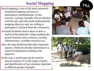
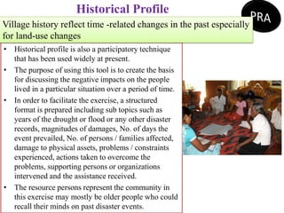
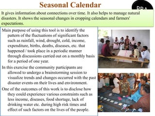
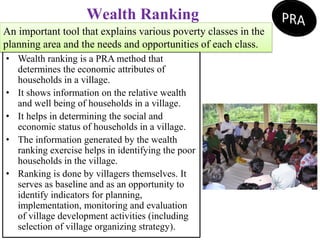
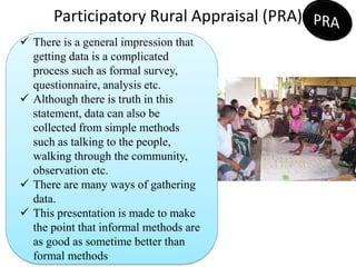
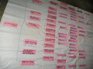
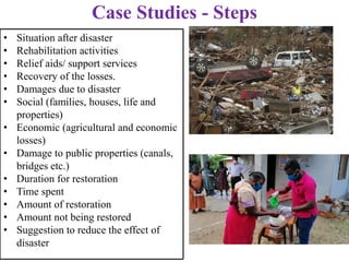
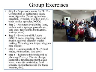
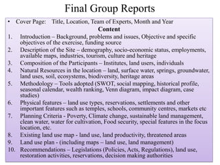
The document provides an overview of participatory rural appraisal (PRA) tools and methods that can be used for participatory land use planning. It defines key terms like PRA and participatory land use planning. It then describes several commonly used PRA tools - focus group discussions, social mapping, historical profiling, seasonal calendars, wealth ranking, Venn diagrams, impact diagrams, case studies, and SWOT analysis. It provides details on how each tool is conducted and the types of information it can provide. The document concludes with proposing the structure and content for final group reports on participatory land use planning exercises.
Disaster risk reduction practices in bangladeshJahangir Alam
Bangladesh
DRR concept
Evolving Paradigms of DM
Actions and Strategies on DRR
Working with Community
Gaps, Concerns, Limitations & Challenges
Learning and Observation
Step Forward
DP ?New generation DRR Practitioner
GANDHI? Conclusion
Bangladesh:
B-Bay of Bengal
A- Agriculture
N-NGOs
G-Garments and GB
L-Land of Rivers
A-Adaptability
D-Disasters, DM, Democracy
E-Emergency
S-SAARC
H-High: Population growth, Vulnerabilities
River bank erosion, its migration, causesNazim Naeem
Riverbank Erosion is an endemic natural hazard in our country.
When rivers enter the mature, they become sluggish and
meander or braid. These oscillations cause extreme riverbank
erosion. It is a perennial problem in our country.
• It has been estimated that tens of thousands of people are
displaced annually by river erosion in Bangladesh, possibly up to
100,000. Many households are forced to move away from their
homesteads due to riverbank erosion and flood.
• As per different sources, 500 kilometres of riverbank face
severe problems related to erosion. The northwest part of the
country is particularly prone to riverbank erosion, which has
turned the region into an economically depressed area.
An informative and brief description of river bank erosion, water quality, sediment quality, sediment load, and hydro-meteorological scenarios of Meghna River in Bangladesh.
he management of water resources has become a critical need in Bangladesh because of growing demand for water and increasing conflict over its alternative uses. As populations expand and make various uses of water, its growing scarcity becomes a serious issue in developing countries such as Bangladesh.
Fluvial Morphology handbook for students.
Contents are: definition, scope, importance of Fluvial Morphology, sediment load, channel pattern and process, role sediment to build delta, Reynolds number, Froude Number, channel pattern of Tista and Jamuna River, causes and consequences of flood, benefit of flood, flood and floodplain, hydraulic geometry, water resource management (in Bangladesh), hydrograph, origin and development of river, tributary and distributary and many more.
Disaster Prevention & Preparedness: Landslide in NepalKamlesh Kumar
This report is detailed study of the field survey conducted in Sindhupalchowk, Nepal. The basic objective of this report is to get a tough insight in the use of field techniques regarding disaster management. Geography deals with human interaction with nature. This phenomenon can be better understood through field studies. Geography, being a field science, a geographical enquiry always need to be supplemented through well planned field surveys. Field is an essential component of geographic enquire. It is a basic procedure to understand the earth as a home of humankind. It is carried out through observation, sketching, measurement, interviews, etc. Field work takes the children out of the class and enables them to better understand the subject by visiting the areas practically giving an insight into the social, cultural and economic lives of the people. This also adds up the advantage of visiting the grass root levels of the society and ameliorative comprehension of the GLOCAL lives. It also has instilled various research making techniques in the budding geographers and shaping their thinking perspectives. The field surveys facilitate the collection of local level information that is not available through secondary sources.
In this report, various methodologies have been employed such as mapping, digitization, measurement and interviewing (questionnaires designing), the collection and gathering of information at the local level by conducting primary surveys and later, tabulating and computing them is an important part of the field survey.
Furthermore, the field study report has been prepared in concise form alongside with maps and diagrams for giving visual impressions. Moreover, it contains all the details of the procedures followed, methods, tools and techniques employed and the modern technology of navigation, satellite connections, GIS software have been very helpful in the pre-field drills.
This is lesson 8 of the course on Research Methodology conducted at the Faculty of Social Sciences and Humanities of the Rajarata University of Sri Lanka
Brief Introduction to PRA
PRA originally stood for Participatory Rural Appraisal, but its applications are in many, many contexts besides rural, and good practice is far more than just appraisal.
PLA stands for Participatory Learning and Action. As a term it is often used interchangeably with PRA.
Appraisal – The finding out of information about problems, needs, and potential in a village or in any settlement. It is the first stage in any project.
This is a presentation made on Climate Smart Agriculture for training of trainers under the project on Building Resilience and Strengthening Community Disaster Preparedness in Sri Lanka
4 Climate Resilience WV English for training of trainersDr. P.B.Dharmasena
This is a presentation made for trainers on Climate Resilience
under the project on Building Resilience and Strengthening Community Disaster Preparedness in Sri Lanka
This is a TOT presentation made on Climate Change Mitigation and Adaptation Strategies for the project - Building Resilience and Strengthening Community Disaster Preparedness in Sri Lanka
2 Climate change on agriculture for training of trainersDr. P.B.Dharmasena
This is a TOT presentation on Agriculture and Climate Change
made for the project - Building Resilience and Strengthening Community Disaster Preparedness in Sri Lanka
1 Climate and Soil for training of trainers.WV English.pdfDr. P.B.Dharmasena
This is a presentation made for trainers on soil and climate under the project on Building Resilience and Strengthening Community Disaster Preparedness in Sri Lanka
Developing 2050 Carbon Net Zero Road Map & Strategic Plan for Sri Lanka - ...Dr. P.B.Dharmasena
This validation workshop was held after preparing the Road Map and Strategic Plan for Sri Lanka and the authors are responsible for the agriculture sector.
Sustainable Water Management in Cascade System: A model in Environmentally Se...Dr. P.B.Dharmasena
Introduction
Origin of tank cascade concept
Tank cascade systems of Sri Lanka: Anatomy, distribution and definitions
Importance of cascade approach
Traditional tank-village ecosystem – adaptive capacity for present situation
Restoration of Tank Cascade Systems for Productivity and SustainabilityDr. P.B.Dharmasena
Presentation made for Technical staff of Climate Resilient Integrated Water Management Project (CRIWMP) at Kurunegala on 9th May 2018
Why cascade systems again?
Drought and flood events can be expected more due to climate change
High prevalence of poverty in tank cascade areas
Mal-nutrition can be greatly reduced by tank fishery and animal husbandry
Better land use under cascade principles – addresses ecological issues such as clearance of village forests, unsustainable land use etc.
Improve living conditions
Health issues ? – drinking water, contamination of agro-chemicals and heavy metals leads to kidney failures, malaria etc.
Most importantly It is an answer to drought hazards
A rainwater harvesting technology;
A soil moisture and groundwater maintaining technology;
A soil erosion and siltation control technology;
A technology that ensured the maintenance of ecological balance;
A technology that promotes social cohesion and needs for community leadership;
A system that accommodates spiritual development which promotes egalitarian (equally treated) attitudes especially during droughts;
A system that nurtured the development of drought insurance through animal husbandry
Cascade Tank Village System and identification of novel post graduate researc...Dr. P.B.Dharmasena
Seminar on Research collaboration opportunities with School of Environment and Rural Science, University of New England, Australia - 14th September 2018, NRMC, Peradeniya, Sri Lanka
Main GHGs from agricultural lands are CH4 and N2O
GHG emission can be reduced by 60 % in 2050 through:
Removal of rice straws and through good management practices in paddy fields
Use alternatives to chemical fertilizer
CH4 reduction from livestock by improving feed quality and animal comfort
Reduce N2O emission in soils
Enhance C sequestration in paddy and rainfed uplands through ‘Evergreen Agro-ecosystem’ concept
Carbon stock in agricultural lands can be enhanced by improving land management practices
C sequestration in tea lands can be increased through: Agro-ecosystem approach; Crop diversification; Intercropping; Introduction of shade trees with optimum density; and Rehabilitation of old tea lands
C stock can be increased by 267 % by the year 2050 through Home Garden Intensification
If the proposed mitigation actions are implemented, the country will be able to achieve Net Zero by 2038.
This lecture was delivered to Agricultural Instructors working for Climate Smart Agriculture Project in 11 districts in the dry zone of Sri Lanka. It includes Climate Smart Agriculture, Special characters in CSA, technological packages for crops such as paddy, maize etc. and livestock such as cattle, poultry etc.
This lecture was delivered for the Agricultural Instructors working for Climate Smart Agriculture project in 11 districts in the dry zone of Sri Lanka. It includes climate change and climate variability, Relevance of global impacts of climate change. Green House Gas (GHG) emission, Reduction of GHG in the agriculture sector, targets for GHG reduction up to 2050, new agriculture concepts to reduce GHG and increase carbon sequestration
Management of Soils in the dry zone of Sri Lanka (Sinhala).pdfDr. P.B.Dharmasena
This lecture was delivered to Agricultural Instructors working for Climate Smart Agriculture Project in 11 dry zone districts of Sri Lanka. It includes most abundant soils in Sri Lanka, Land degradation, Sustainable Land Management, new concepts immerged in agriculture to address climate change impacts.
The lecture delivered for Agricultural Instructors working for Climate Smart Agriculture Project in 11 districts of Sri Lanka. It explains the difference between climate and weather, factors affecting climate variation in Sri Lanka, Rainfall, altitude, degree of wetness etc.
Characterization and the Kinetics of drying at the drying oven and with micro...Open Access Research Paper
The objective of this work is to contribute to valorization de Nephelium lappaceum by the characterization of kinetics of drying of seeds of Nephelium lappaceum. The seeds were dehydrated until a constant mass respectively in a drying oven and a microwawe oven. The temperatures and the powers of drying are respectively: 50, 60 and 70°C and 140, 280 and 420 W. The results show that the curves of drying of seeds of Nephelium lappaceum do not present a phase of constant kinetics. The coefficients of diffusion vary between 2.09.10-8 to 2.98. 10-8m-2/s in the interval of 50°C at 70°C and between 4.83×10-07 at 9.04×10-07 m-8/s for the powers going of 140 W with 420 W the relation between Arrhenius and a value of energy of activation of 16.49 kJ. mol-1 expressed the effect of the temperature on effective diffusivity.
WRI’s brand new “Food Service Playbook for Promoting Sustainable Food Choices” gives food service operators the very latest strategies for creating dining environments that empower consumers to choose sustainable, plant-rich dishes. This research builds off our first guide for food service, now with industry experience and insights from nearly 350 academic trials.
Artificial Reefs by Kuddle Life Foundation - May 2024punit537210
Situated in Pondicherry, India, Kuddle Life Foundation is a charitable, non-profit and non-governmental organization (NGO) dedicated to improving the living standards of coastal communities and simultaneously placing a strong emphasis on the protection of marine ecosystems.
One of the key areas we work in is Artificial Reefs. This presentation captures our journey so far and our learnings. We hope you get as excited about marine conservation and artificial reefs as we are.
Please visit our website: https://kuddlelife.org
Our Instagram channel:
@kuddlelifefoundation
Our Linkedin Page:
https://www.linkedin.com/company/kuddlelifefoundation/
and write to us if you have any questions:
info@kuddlelife.org
"Understanding the Carbon Cycle: Processes, Human Impacts, and Strategies for...MMariSelvam4
The carbon cycle is a critical component of Earth's environmental system, governing the movement and transformation of carbon through various reservoirs, including the atmosphere, oceans, soil, and living organisms. This complex cycle involves several key processes such as photosynthesis, respiration, decomposition, and carbon sequestration, each contributing to the regulation of carbon levels on the planet.
Human activities, particularly fossil fuel combustion and deforestation, have significantly altered the natural carbon cycle, leading to increased atmospheric carbon dioxide concentrations and driving climate change. Understanding the intricacies of the carbon cycle is essential for assessing the impacts of these changes and developing effective mitigation strategies.
By studying the carbon cycle, scientists can identify carbon sources and sinks, measure carbon fluxes, and predict future trends. This knowledge is crucial for crafting policies aimed at reducing carbon emissions, enhancing carbon storage, and promoting sustainable practices. The carbon cycle's interplay with climate systems, ecosystems, and human activities underscores its importance in maintaining a stable and healthy planet.
In-depth exploration of the carbon cycle reveals the delicate balance required to sustain life and the urgent need to address anthropogenic influences. Through research, education, and policy, we can work towards restoring equilibrium in the carbon cycle and ensuring a sustainable future for generations to come.
UNDERSTANDING WHAT GREEN WASHING IS!.pdfJulietMogola
Many companies today use green washing to lure the public into thinking they are conserving the environment but in real sense they are doing more harm. There have been such several cases from very big companies here in Kenya and also globally. This ranges from various sectors from manufacturing and goes to consumer products. Educating people on greenwashing will enable people to make better choices based on their analysis and not on what they see on marketing sites.
Natural farming @ Dr. Siddhartha S. Jena.pptxsidjena70
A brief about organic farming/ Natural farming/ Zero budget natural farming/ Subash Palekar Natural farming which keeps us and environment safe and healthy. Next gen Agricultural practices of chemical free farming.
Willie Nelson Net Worth: A Journey Through Music, Movies, and Business Venturesgreendigital
Willie Nelson is a name that resonates within the world of music and entertainment. Known for his unique voice, and masterful guitar skills. and an extraordinary career spanning several decades. Nelson has become a legend in the country music scene. But, his influence extends far beyond the realm of music. with ventures in acting, writing, activism, and business. This comprehensive article delves into Willie Nelson net worth. exploring the various facets of his career that have contributed to his large fortune.
Follow us on: Pinterest
Introduction
Willie Nelson net worth is a testament to his enduring influence and success in many fields. Born on April 29, 1933, in Abbott, Texas. Nelson's journey from a humble beginning to becoming one of the most iconic figures in American music is nothing short of inspirational. His net worth, which estimated to be around $25 million as of 2024. reflects a career that is as diverse as it is prolific.
Early Life and Musical Beginnings
Humble Origins
Willie Hugh Nelson was born during the Great Depression. a time of significant economic hardship in the United States. Raised by his grandparents. Nelson found solace and inspiration in music from an early age. His grandmother taught him to play the guitar. setting the stage for what would become an illustrious career.
First Steps in Music
Nelson's initial foray into the music industry was fraught with challenges. He moved to Nashville, Tennessee, to pursue his dreams, but success did not come . Working as a songwriter, Nelson penned hits for other artists. which helped him gain a foothold in the competitive music scene. His songwriting skills contributed to his early earnings. laying the foundation for his net worth.
Rise to Stardom
Breakthrough Albums
The 1970s marked a turning point in Willie Nelson's career. His albums "Shotgun Willie" (1973), "Red Headed Stranger" (1975). and "Stardust" (1978) received critical acclaim and commercial success. These albums not only solidified his position in the country music genre. but also introduced his music to a broader audience. The success of these albums played a crucial role in boosting Willie Nelson net worth.
Iconic Songs
Willie Nelson net worth is also attributed to his extensive catalog of hit songs. Tracks like "Blue Eyes Crying in the Rain," "On the Road Again," and "Always on My Mind" have become timeless classics. These songs have not only earned Nelson large royalties but have also ensured his continued relevance in the music industry.
Acting and Film Career
Hollywood Ventures
In addition to his music career, Willie Nelson has also made a mark in Hollywood. His distinctive personality and on-screen presence have landed him roles in several films and television shows. Notable appearances include roles in "The Electric Horseman" (1979), "Honeysuckle Rose" (1980), and "Barbarosa" (1982). These acting gigs have added a significant amount to Willie Nelson net worth.
Television Appearances
Nelson's char
1. PART 3 - PARTICIPATORY RURAL
APPRAISAL (PRA)
Training Workshop on Participatory Land Use Planning – 6th – 7th
December 2021 at SLFI, Colombo
• P.B. Dharmasena
• 0777 - 613234, 0717 – 613234
• dharmasenapb@ymail.com , dharmasenapb@gmail.com
• Links to publications:
https://independent.academia.edu/PunchiBandageDharmasena
https://www.researchgate.net/profile/Punchi_Bandage_Dharmasena/contributions
http://www.slideshare.net/DharmasenaPb
https://www.youtube.com/channel/UC_PFqwl0OqsrxH1wTm_jZeg
2. Participatory Rural Appraisal (PRA)
Lesson-8
There is a general impression that
getting data is a complicated
process such as formal survey,
questionnaire, analysis etc.
Although there is truth in this
statement, data can also be
collected from simple methods
such as talking to the people,
walking through the community,
observation etc.
There are many ways of gathering
data.
This presentation is made to make
the point that informal methods are
as good as sometime better than
formal methods
3. Definition of Participatory Rural Appraisal
It enables them to go for a process to plan, implement,
monitor and evaluate their nature of life and the
living environment.
S.V.P.Nilame
PRA is a set of tools that can be adopted to increase the
ability of the community to analyze, understand
and share with others of the life and their living
environment.
4. Definition of Participatory Land Use Planning
• Participatory Land-use planning is a
systematic and iterative procedure
carried out in order to create an
enabling environment for sustainable
development of land resources which
meets people's needs and demands.
• It assesses the physical, socio-
economic, institutional and legal
potentials and constraints with respect
to an optimal and sustainable use of
land resources, and empowers people
to make decisions about how to
allocate those resources
- FAO/UNEP/GTZ (1999): The Future of
Our Land - Facing the Challenge
• .
5. Focus Group Discussions (FGDs)
A tool to identify the insightful understanding of land-use
problems in a mini watershed that cannot be gained through large
meetings or surveys.
1. A focus group discussion (FGD) is a group discussion of 6-12 persons guided by
a facilitator, during which group members talk freely and spontaneously about a
certain topic. The purpose of an FGD is to obtain in-depth information on
concepts, perceptions, and ideas of the group. It aims to be more than a question-
answer interaction.
2. FGD techniques can be used to:
1. Develop relevant research hypotheses by exploring in greater depth the
problem to be investigated and its possible causes.
2. Formulate appropriate questions for more structured, larger scale surveys.
3. Supplement information on community knowledge, beliefs, attitudes, and
behaviour already available but incomplete or unclear.
4. FGDs are not used to test hypotheses or to produce research findings that
can be generalized.
6. Functions of the facilitator:
1. Introduce the session
2. Encourage discussion
3. Encourage involvement
4. Listen carefully and move the
discussion from topic to topic.
Subtly control the time
allocated to various topics so
as to maintain interest.
5. Take time at the end of the
meeting to summarize, check
for agreement and thank the
participants.
In general, the facilitator should not act
as an expert on the topic. His or her
being there is to stimulate and support
discussion.
Focus Group Discussions (FGDs)
7. Social Mapping
Shows where resources, activities, problems, and opportunities are located. It also
provides the dimension and scope of issues to be investigated. This exercise can be
improved now by using enlarged satellite images of the village/mini watershed.
Topographical information, information on soils, vegetation, agroecological zones,
water availability, distribution of infrastructure facility, natural disasters, etc. can be
included into this map.
8. Social Mapping
Social mapping is one of the most commonly
conducted mapping exercises in
participatory methodologies. In this
exercise, a group of people who are familiar
with the area and who could understand the
mapping objective and, are willing to
participate is selected from the community.
A trained facilitator directs them to draw a
sketch of the particular village marking the
general features such as houses, existing
infrastructures, available resources etc.
Also, the map should include other important
aspects, which are already determined in a
check-list prepared according to the
objective.
In this way, a social map can be used for
special analysis of a wide range of topics
and identification of key elements important
to different groups of people.
9. Historical Profile
• Historical profile is also a participatory technique
that has been used widely at present.
• The purpose of using this tool is to create the basis
for discussing the negative impacts on the people
lived in a particular situation over a period of time.
• In order to facilitate the exercise, a structured
format is prepared including sub topics such as
years of the drought or flood or any other disaster
records, magnitudes of damages, No. of days the
event prevailed, No. of persons / families affected,
damage to physical assets, problems / constraints
experienced, actions taken to overcome the
problems, supporting persons or organizations
intervened and the assistance received.
• The resource persons represent the community in
this exercise may mostly be older people who could
recall their minds on past disaster events.
Village history reflect time -related changes in the past especially
for land-use changes
10. Seasonal Calendar
Main purpose of using this tool is to identify the
pattern of the fluctuations of significant factors
such as rainfall, wind, drought, cold, income,
expenditure, births, deaths, diseases, etc. that
happened / took place in a periodic manner
through discussions carried out on a monthly basis
for a period of one year.
In this exercise the community participants are
allowed to undergo a brainstorming session to
visualize trends and changes occurred with the past
disaster events on their lives and environment.
One of the outcomes of this work is to disclose how
they could experience various constraints such as
less income, diseases, food shortage, lack of
drinking water etc. during high risk times and
effect of such factors on the lives of the people.
It gives information about connections over time. It also helps to manage natural
disasters. It shows the seasonal changes in cropping calendars and farmers'
expectations.
11. Wealth Ranking
• Wealth ranking is a PRA method that
determines the economic attributes of
households in a village.
• It shows information on the relative wealth
and well being of households in a village.
• It helps in determining the social and
economic status of households in a village.
• The information generated by the wealth
ranking exercise helps in identifying the poor
households in the village.
• Ranking is done by villagers themselves. It
serves as baseline and as an opportunity to
identify indicators for planning,
implementation, monitoring and evaluation
of village development activities (including
selection of village organizing strategy).
An important tool that explains various poverty classes in the
planning area and the needs and opportunities of each class.
12. Venn Diagram
• Venn diagram is a participatory tool that is commonly
used to assess relationships among various actors /
stakeholders who hold a task / responsibility / stake in
order to address / attend a given issue or a situation.
• It is of twofold; first is a comparative assessment
among identified set of stakeholders & institutions in
terms of their importance in addressing a given
situation or issue. Second is also a comparative
assessment about the quality of service delivery of the
same stakeholders or institutions.
• Once the stakeholders & institutions are identified,
the discussion takes place to rank these according to
the value / importance of the services delivered in
relation to the situation or issue needing attention.
• Once the ranking is complete, the second stage of the
discussion on closeness / satisfaction begins. Each of
the stakeholder / institution will be assessed in terms
of satisfaction of the service they deliver and the
closest ones will be kept very close.
14. SWOT Analysis
• SWOT analysis is a tool that is commonly used to assess options available to
overcome identified impacts/ effects prior to determining an action / solution for
these. The term ‘SWOT’ stands for Strengths, Weaknesses, Opportunities and
Threats respectively.
• Strengths & weaknesses are the internal assessment, where the reflection would
focus on ‘what are the strengths within us that we can use to overcome / address a
certain issue’ and ‘what are the weaknesses lie within us that hinder overcoming /
addressing a certain issue’.
• Likewise Opportunities & Threats are the external assessment, where the reflection
would focus on ‘what are the opportunities that are there in our environment, that
we can use to overcome / address a certain weakness lie within us’ and ‘what are the
threats that are there in our environment that are beyond our control’.
• Ultimately, this analysis allows a self-reflection on the possibility of acting on /
overcoming a certain issue, thus enables finding feasible solutions for
implementation.
• In this study, SWOT analysis is used to reflect on the current situation prior to
determination of action for implementation, to reduce the effect of negative impacts
on lives of people.
15. • The participatory tools/ exercises discussed above are used
to generate a situational analysis, which is then used as a
base to discuss impacts/ effects of the issue on people’s
lives. ‘Impact diagram’ is the tool that was used for this
purpose.
• Impact diagram is used to identify the psychological and
physical damages as well as other losses of the affected
people due to a disaster in selected locations of the five
districts. Further, the diagram could reveal the negative
effects socially and culturally faced by the people due to
the disaster.
Impact Diagram
17. Case Studies
A case study means a review of past event, which needs special attention
or differs from standard way/ system. It is an in-depth discussion on a
particular event with the people who experienced it.
In case of disasters topics of major concern are how they identify the
warning signals of the disaster, how they could respond to or face the
disaster, and what changes occurred with respect to social, economic
and environmental situations etc.
Most important part of the exercise is to identify desirable and
undesirable features they had in the past and ways and means to
improve the situation, so that the community could respond the
disaster with minimum effect to them from the disaster.
However, there is a need to consider the changes occurred with time and
discuss how they could adjust to the present time.
The group selected for the discussion should be the people who really
were affected by the disaster. In the discussion the most familiar
questions are begun with what?, how ?, when ?, where?, who? and
why?.
18. • Preparation of a semi-structured
format.
• Introduce the objective of the
discussion correctly.
• Encourage more detailed
descriptions than short answers
• Review of social status before the
disaster
– Land area, population, houses
etc.
– Agricultural and economic
status
– Public facilities (transport,
health, education etc.)
• Reasons for occurrence of disasters
– Environmental factors
– Human activities
Case Studies - Steps
19. • Pre-disaster signals
– Days/ hours before the disaster occurs
– Just before the disaster
• Preparedness for the disaster
– Storing food, water etc.
– Collection of medicines
– Attention to pre-disaster warning signals (natural/ media)
– Preparation of temporary huts, required implements etc.
• Response to the disaster
– Protection from and been organized for the disaster situation
– Taking affected people to a safe place
– Seeking assistance from Government and other organization
Case Studies - Steps
20. • Situation after disaster
• Rehabilitation activities
• Relief aids/ support services
• Recovery of the losses.
• Damages due to disaster
• Social (families, houses, life and
properties)
• Economic (agricultural and economic
losses)
• Damage to public properties (canals,
bridges etc.)
• Duration for restoration
• Time spent
• Amount of restoration
• Amount not being restored
• Suggestion to reduce the effect of
disaster
Case Studies - Steps
21. Group Exercises
• Step 1 - Preparatory works for PLUP –
Composition of participants (Land
users, Agencies (forest, agriculture,
irrigation, livestock, wild life, CBOs),
other service agencies, NGOs)
• Step 2 - Resources availability (land,
surface water, springs, groundwater,
land uses, ecosystems, biodiversity,
heritage areas)
• Step 3 – Selection of PRA tools
(SWOT, social mapping, historical
profile, seasonal calendar, wealth
ranking, Venn diagram, impact diagram,
case studies)
• Step 4 - Legal aspects of PLUP (land
tenure, reservations, land uses)
• Step 5 – Factors to be considered in
planning (Poverty, Climate change,
sustainable land management, clean
water, water for cultivation, food
security, special features in the focus
location, etc.).
22. Final Group Reports
• Cover Page: Title, Location, Team of Experts, Month and Year
Content
1. Introduction – Background, problems and issues, Objective and specific
objectives of the exercise, funding source
2. Description of the Site – demography, socio-economic status, employments,
available maps, industries, tourism, culture and heritage
3. Composition of the Participants – Institutes, land users, individuals
4. Natural Resources in the location – land, surface water, springs, groundwater,
land uses, soil, ecosystems, biodiversity, heritage areas
5. Methodology – Tools adopted (SWOT, social mapping, historical profile,
seasonal calendar, wealth ranking, Venn diagram, impact diagram, case
studies)
6. Physical features – land use types, reservations, settlements and other
important features such as temples, schools, community centres, markets etc
7. Planning Criteria - Poverty, Climate change, sustainable land management,
clean water, water for cultivation, Food security, special features in the focus
location, etc.
8. Existing land use map - land use, land productivity, threatened areas
9. Land use plan - (including maps – land use, land management)
10. Recommendations – Legislations (Policies, Acts, Regulations), land use,
restoration activities, reservations, decision making authorities