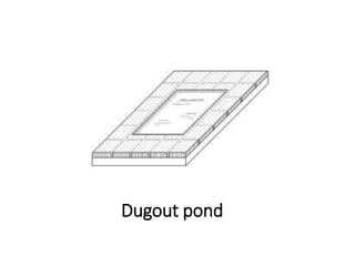
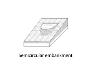
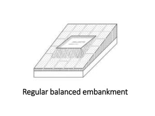
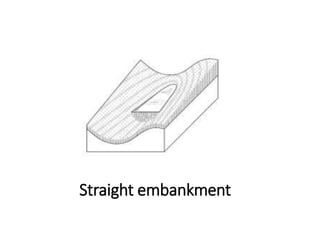
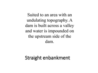
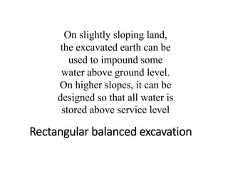
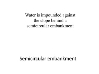
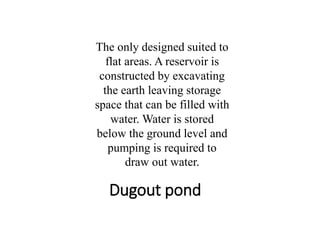
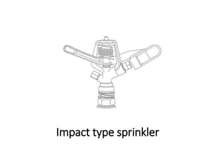
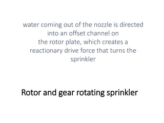
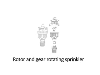
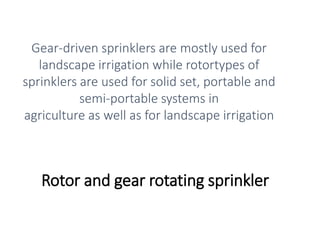
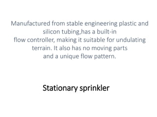
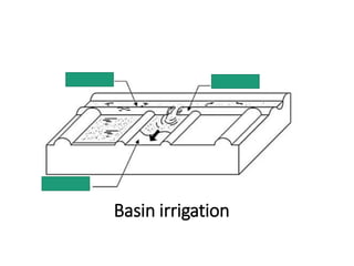
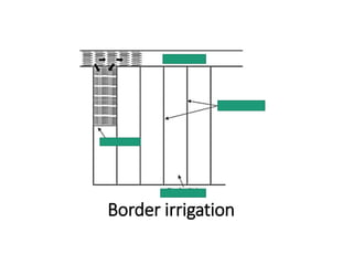
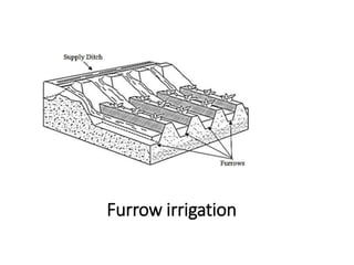
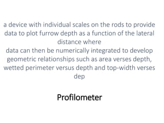
PAES: IRRIGATION STRUCTURE
Prepared by:
ENGR. ELMAN C. TORRES, MSc.
Registered Agricultural Engineer
Project Assistant II, DOST PSTC Nueva Ecija
engr.ectorres@gmail.com
access areas
areas open for public entry such as golf
courses, public and private parks,
playgrounds, schoolyards and playing
fields, residential landscapes and industrial
park landscapes
active storage
volume of water stored in reservoir
between the minimum water level and
normal water level
actual crop evapotranspiration
rate of evapotranspiration equal to or
smaller than predicted crop
evapotranpiration as affected by the level
of available soil water, salinity, field size or
other causes
afflux elevation
rise in maximum flood level from the original
unobstructed flood level which result after an
obstruction to the flow such as a dam, has been
introduced
algal bloom
overgrowths of algae in water producing
dangerous toxins in fresh or marine water
application efficiency
ratio of the average depth of irrigation
water infiltrated and stored in the root
zone to the average depth of irrigation
water applied
aquifer
geologic formation which contains water
and transmits it at a rate sufficient to be
economically developed for pumping
artificially developed well
basin
field that is level in all directions,
encompassed by a dike to prevent runoff,
and provides an undirected flow of water
onto the field
basin irrigation
type of surface irrigation where water is
applied to the basin through a gap in the
perimeter dike or adjacent ditch; water is
retained until it infiltrates into the soil or
the excess is drained off
bearing capacity
maximum average contact pressure
between the foundation and the soil which
should
not produce shear failure in the soil
border irrigation
method of irrigation which makes use of
parallel border strips where the water
flows down the slope at a nearly uniform
depth
border strip
area of land bounded by two border ridges
or dikes that guide the irrigation stream
from the inlet point of application to the
ends of the strip
channel bed slope
inclination or elevation drop per unit
length of the channel bottom
confined aquifer
groundwater that is confined by relatively
impermeable layer
contamination
introduction of substances not found in
the natural composition of water that
make the water less desirable or unfit for
intended use
conveyance efficiency
ratio between water received at the inlet
for a block of fields to that released at the
project’s headwork
conveyance loss
loss of water from a channel during
transport due to seepage and percolation
critical depth
depth of water flow where the energy
content is at minimum hence, no other
backwater forces are involved
crop coefficient
ratio of the actual crop evpotranspiration
to its potential evapotranspiration
crop evapotranspiration
rate of evapotranspiration of a disease-free crop growing in a
large field (one or more
ha) under optimal soil conditions, including sufficient water and
fertilizer and achieving full production potential of that crop
under the given growing environment; includes water loss
through transpiration by the vegetation, and vaporation from
the soil surface and wet leaves
cropping pattern
sequence of different crops grown in
regular order on any particular field or
fields
crop water requirements
amount of water used in producing crops
which is the sum of evapotranspiration or
consumptive use plus seepage and
percolation losses
dam
any barrier constructed to store water
active storage
volume of water stored in reservoir
between the minimum water level and
normal water level
dam height
vertical distance from lowest point of the
ground line to the dam crest
dead storage
volume below the intake structure;
sediment volume based on 25 years of
accumulation in the reservoir
depth
depth of water in the channel cross-
section
designed height
actual height of the embankment after
settlement
active storage
volume of water stored in reservoir
between the minimum water level and
normal water level
design irrigable area
maximum area which an irrigation project
can serve considering the extent of arable
lands and the available water supply
distribution uniformity
numerical value on the uniformity of
application for agricultural irrigation
systems
diversion dam
structure or weir provided across the river
or creek to raise its water level and divert
the water into the main canal to facilitate
irrigation by gravity
diversion water requirement
the total quantity of water diverted from a
stream, lake, or reservoir, or removed from
the ground in order to irrigate a crop
drip irrigation
trickle irrigation
involves dripping water onto the soil at very low rates
(2-20 litres/hour) from the
emitters where water is applied close to plants so
that only part of the soil in which
the roots grow is wetted
drop
in-line canal structure designed to convey
canal water from a higher level to a lower
level, duly dissipating the excess energy
resulting from the drop in elevation
effective rainfall
amount of rainwater that falls directly on
the field and is used by the crop for growth
and development excluding deep
percolation, surface runoff and
interception
effective rooting depth
soil depth from which the bulk of the roots
of the crop extracts most of the water
needed for evapotranspiration
effective size
particle diameter corresponding to a 10%
sieve passing
effluent
discharges from known sources which is passed into
a body of water or land, or
wastewater flowing out of a manufacturing plant,
industrial plant including domestic,
commercial and recreational facilities
effluent standard
any legal restriction or limitation on quantities, rates,
and/or concentrations or any combination thereof, of
physical, chemical or biological parameters of
effluent which a person or point source is allowed to
delivery into a body of water or land
elevated flume
water conveying conduit or trough which is
supported on abutments by piers
emitter spacing
spacing between emitters or emission
points along a lateral line
emitters
applicator used in drip, subsurface, or bubbler
irrigation designed to disspate pressure and to
discharge a small uniform flow or trickle of water at a
constant rate that does not vary significantly because
of minor differences in pressure
energy grade line
specific energy line
grade line of the water surface profile plus
the velocity head in open channels
equipment crossing
provision for passing of equipment and
small machinery
evapotranspiration
combination of water transpired from
vegetation and evaporated from the soil,
water,
and plant surfaces.
farm ditch
channel which conveys irrigation water
from the turnout to the paddy field
filter drain
dam component which prevents migration
of small particles and screen off fine
materials that flow with seepage water
and prevent piping
finished height
height of the embankment to be attained
during construction
farm water requirement
amount of water to replenish the crop
water requirement and losses less the
effective
rainfal
freeboard
additional height of the dam provided as a
safety factor to prevent overtopping by
wave action or other causes
furrows
small parallel channels, made to carry
water in order to irrigate the crop
furrow irrigation
method of irrigation where water runs
through small parallel channels as it moves
down the slope of the field
head ditch
supply ditch
small channel along one part of a field that
is used for distributing water in surface
irrigation
homogeneous embankment
dam composed of a single kind of
embankment material exclusive for slope
protection
hydraulic depth
ratio of flow area to the wetted top width
hydraulic grade line
hydraulic gradient
profile of the free water surface
hydraulic radius
cross-sectional area of flow divided by the
wetted perimeter
hydrologic frequency analysis
estimation of the chance or likelihood of
occurrence of a given event by
determining the frequency curves of best
fit to samples of hydrologic data
inside slope
slope of the upstream face of the
embankment
invert
inside bottom or sill of t the condui
inverted siphon
closed conduit designed to convey canal water in full
and under pressure running condition, to convey
canal water by gravity under roadways, railways,
drainage channels and local depressions
irrigation period
time required to cover an area with one
application of water
DENR Administrative Order 35
series of 1990
Revised Effluent Regulations
Karst topography
geological formation shaped by the
dissolution of a layer or layers of soluble
bedrock,
usually carbonate rocks such as limestone
or dolomite
land preparation water
requirement
amount of water required in lowland rice
production which includes water losses
through evaporation, seepage and
percolation and land soaking
land soaking water requirement
amount of water required in lowland rice
production which is a function of the initial
soil moisture and the physical properties of
the soil
lateral spacing
spacing between irrigation laterals
leaching
deep percolation of water beyond the root
zone of plants, resulting in loss of salts or
nutrients
lined channel
lined canal
canals with impermeable material (usually
concrete) for channel stabilization and/or
reduced seepage
loading limit
allowable pollutant-loading limit per unit
of time, which the wastewater generator is
permitted to discharge into any receiving
body of water or land
manifold
portion of the pipe network between the
mainline and the laterals
manufacturer’s coefficient of
variation
measure of the variability of discharge of a random
sample of a given make, model
and size of emitter, as provided by the manufacturer
and before any field operations
or aging has taken place determined through a
discharge test of a sample of 50
emitters under a set pressure at 200 0C
natural spillway
spillway which is not excavated such as
natural draw, saddle or drainage way
normal depth
constant flow depth along a longitudinal
section of a channel under a uniform flow
condition
normal storage elevation
maximum elevation the water surface
which can be attained by the dam or
reservoir
without flow in the spillway
open channel flow
water flow that is conveyed in such a
manner that top surface is exposed to the
atmosphere such as flow in canals, ditches,
drainage channels, culverts, and pipes
under partially full flow conditions
optimal emitter spacing
drip emitter spacing which is 80% of the
wetted diameter estimated from field tests
pan coefficient
ratio between reference
evapotranspiration and water loss by
evaporation from an
open water surface of a pan
pan evaporation
rate of water loss by evaporation from an
open water surface of a pan
percolation
vertical flow of water to below the root
zone which is affected by soil structure,
texture, bulk density, mineralogy, organic
matter content, salt type and
concentration
permeability test
method to determine the rate of flow
under laminar flow conditions through a
unit cross sectional are of soil under unit
hydraulic gradient
pollutant
any substance, whether solid, liquid, gaseous or radioactive, which directly or
indirectly alters the quality of any segment of the receiving water body or land
resource so as to affect or tend to affect adversely any beneficial use thereof, or is hazardous
or potentially hazardous to health, or imparts objectionable odor, temperature change or
physical, chemical or biological change to any segment of the water body or land, or is in
excess of the allowable limits or concentrations or quality standards specified in contravention
of the condition, limitation or restriction prescribed in these guidelines
pond
sealed section formed between earth
embankments where combined seepage
and
percolation will be measured
potential irrigable area
area capable of being irrigated, principally
as regards to availability of water, suitable
soils, and topography of land
reference crop evapotranspiration
rate of evapotranspiration from a
reference surface which is a hypothetical
reference crop with an assumed crop
height of 0.2 m, a fixed surface resistance
of 70 s/m and an albedo of 0.23
reservoir
part of the system that impounds the
runoff
residual moisture content
moisture left in the soil before the initial irrigation
water delivery which describes the
extent of water depletion from the soil when the
water supply has been cut-off
restricted areas
areas with limited entry such as freeway landscape,
highway medians and other similar areas
re-use
taking wastewater from one industry or
process, treating it and then using it in
another
process or industry such as for irrigation,
as liquid fertilizer and for aquaculture
road crossing
conveys canal water under roads or
railroad
shallow tubewell
tube or shaft vertically set into the ground at a depth
that is usually less than 15 m for
the purpose of bringing groundwater into the soil
surface whose pumps are set above
the water level
seismicity
occurrence or frequency of earthquakes in
a region
seepage
water escaping below or out from water
conveyance facilities such as open ditches,
canals, natural channels, and waterway
seepage line
phreatic line
line with no filter arrangements where
seepage occurs
setback distance
distance from the perimeter of the
irrigation area to the community or area of
concern
that is sensitive to contamination
side slope
ratio of the horizontal to vertical
dimension of the channel wall
slope of the energy grade line
slope of the water surface profile plus the
velocity head in open channels
slope of the hydraulic grade line
slope of the free water surface
spillway
channel which releases surplus or flood
water which cannot be contained in the
active
storage space of the reservoir
sprinkler irrigation
method of applying irrigation water similar to natural
rainfall where water is
distributed through a system of pipes by pumping and
then sprayed into the air
through sprinklers so that it breaks up into small water
drops which fall to the ground
sprinkler spacing
distance between two sprinkler heads
along the lateral
storage capacity
total capacity at normal water surface
elevation
storage ratio
ratio of the storage capacity to the total
earth volume required for embankment
construction which indicates the relative
cost of the different types of reservoir
structural height
vertical distance measured from the top of
the dam down to the bedrock
surface irrigation system
application of water by gravity flow to the surface
of the field. Either the entire field
is flooded (basin irrigation) or the water is fed into
small channels (furrows) or strips
of land (borders)
top width
width of the channel cross-section at the
free surface
unconfined aquifer
aquifer which has water table serving as
upper surface of the zone of saturation
uniformity coefficient
ratio of the particle size at 60% pasing to
that at 10% passing
uniform flow
occurs when flow has a constant water
area, depth, discharge, and average
velocity through a reach of channel
unimodal rainfall pattern
rainfall pattern with five wet months of more than
200 mm/month, five dry months of
less than 100 mm/month, two transition months of
100mm-200mm/month and total
annual rainfall above 1500 mm.
unlined channels
unlined canal
canals that are cut through the soil, in
which the soil excavated from the bed are
used
to form the embankment
upstream face
side of the embankment wetted by the
impounded water
waste
any material either solid, liquid, semi-solid,
contained gas or other forms resulting
from industrial, commercial, mining, or agricultural
operations, or from community
and household activities that is devoid of usage and
discarded
wastewater
waste in liquid state containing pollutants
water balance
accounting of water inflows, such as
irrigation and rainfall, and outflows, such
as
evaporation, seepage and percolation
watershed
area which contributes runoff or drains
water into the reservoir
water right
privilege granted by the government to
use and appropriate water
well log
record of formation stratification of an
aquifer showing the depth, thickness,
degree of
consolidation and other aquifer phy
well-protected reservoir
reservoir where the upper reaches of the
basin is shielded by high mountain barriers
wetted diameter
diameter of the circular area wetted by the
sprinkler when operating at a given
pressure and no wind
wetted perimeter
portion of the perimeter of the canal that
is in contact with the flowing water
wetted widths
width of the strip that would be wetted by
a row of emitters spaced at their optimal
spacing along a single lateral line
zoned embankment
dam consisting a central impervious core
flanked between zones of more pervious
materials
actual crop evapotranspiration
ETa
rate of evapotranspiration equal to or
smaller than predicted ETcrop as affected
by the level of available soil water, salinity,
field size or other causes
application efficiency
Ea
ratio of the average depth of irrigation
water infiltrated and stored in the root
zone to
the average depth of irrigation water
applied
conveyance efficiency
Ec
ratio between water received at the inlet
for a block of fields to that released at the
project’s headwork
crop coefficient
kc
ratio of the actual crop evpotranspiration
to its potential evapotranspiration
crop evapotranspiration
rate of evapotranspiration of a disease-free crop growing in a large field
(one or more ha) under optimal soil conditions, including sufficient
water and fertilizer and achieving full production potential of that crop
under the given growing environment; includes water loss through
transpiration by the vegetation, and vaporation from the
soil surface and wet leaves
cropping pattern
sequence of different crops grown in
regular order on any particular field or
fields
crop water requirement
CWR
amount of water used in producing crops
which is the sum of evapotranspiration or
consumptive use plus seepage and
percolation losses
diversion water requirement
DWR
the total quantity of water diverted from a
stream, lake, or reservoir, or removed from
the ground in order to irrigate a crop
effective rainfall
ER
amount of rainwater that falls directly on
the field and is used by the crop for growth
and development excluding deep
percolation, surface runoff and
interception
effective rooting depth
soil depth from which the bulk of the roots
of the crop extracts most of the water
needed for evapotranspiration
evapotranspiration
combination of water transpired from
vegetation and evaporated from the soil,
water,
and plant surfaces
farm water requirement
FWR
amount of water to replenish the crop
water requirement and losses less the
effective
rainfall
hydrologic frequency analysis
estimation of the chance or likelihood of
occurrence of a given event by
determining
the frequency curves of best fit to samples
of hydrologic data
land preparation water
requirement
LPWR
amount of water required in lowland rice
production which includes water losses
through evaporation, seepage and
percolation and land soaking
land soaking water requirement
LSR
amount of water required in lowland rice
production which is a function of the initial
soil moisture and the physical properties of
the soil
pan coefficient
ratio between reference
evapotranspiration (ETo) and water loss by
evaporation from
an open water surface of a pan
pan evaporation
rate of water loss by evaporation from an
open water surface of a pan
percolation
vertical flow of water to below the root
zone which is affected by soil structure,
texture, bulk density, mineralogy, organic
matter content, salt type and
concentration
reference crop evapotranspiration
ETo
rate of evapotranspiration from a
reference surface which is a hypothetical
reference
crop with an assumed crop height of 0.2
m, a fixed surface resisteance of 70 s/m
and
an albedo of 0.23
residual moisture content
moisture left in the soil before the initial
irrigation water delivery which describes
the extent of water depletion from the soil
when the water supply has been cut-off
seepage
water escaping below or out from water
conveyance facilities such as open ditches,
canals, natural channels, and waterway
Conveyance loss
is the sum of the seepage and percolation
losses in the
conveyance structures (main canal to the
sub-laterals), leakage through gates and
leftover water in the canals and leakage
through canal dikes.
conveyance loss
loss of water from a channel during
transport due to seepage and percolation
pumping test
pumping of water from a fully developed well at a
controlled rate and observing, with
respect to time, the drawdown in two or more
observation wells, in order to determine
the aquifer hydrologic properties
Dug Well
used in unconsolidated formations with
large diameters which
permit considerable water storage.
Bored Well/Augered Well
used in formations with very shallow water
depths
Driven Well
used in unconsolidated formations with
shallow water tables
that contain not too many rocks
Jetted Well
– constructed by the cutting action of a
downward-directed steam
of water to excavate the hole and carry the
excavated materials out of the hole.
check dam
small barrier built across the direction of water flow on
shallow rivers and streams
intended to convey runoff during peak flow and to slow
and hold surface water long
enough for the water to deposit sediment it is carrying;
facilitates irrigation by using
the upstream bay of the dam as pump sump
gabion
stones wrapped in wire fence meshes for
added stability and strength
Brushwood check dam
Log check dam
Loose stone check dam
Boulder check dam
Masonry check dam
Gabion check dam
hydraulic jump
occurs when a thin sheet of incoming flow
moving at high velocity strikes water of
sufficient depth
piping
internal erosion induced by regressive
erosion of particles from downstream and
along the upstream line towards an
outside environment
rockfill dam
dam that relies on rock, either dumped in lifts or
compacted in layers, as a major
structural element where an impervious membrane is
used as the water barrier and can be placed either
within the embankment or on the upstream slope
Impervious Zone
composed of impervious blanket usually made of
cohesive soil or non-cohesive silt and is covered for
protection. Materials shall have the required
coefficient of permeability with a smaller
compressibility after compaction, shall be easy to be
compacted, and shall not contain organic substances.
Rockfill Zone or Pervious Zone
consists of a well-graded mixture of hard
and durable particles, and slightly
weathered to fresh rock to secure the
stability of
dam body
seismometer
provides sufficient amplification to record any minor
local
earthquake event, thus providing a continuous record
of local seismic activity
during the construction of the dam, filling of the
reservoir and dam operation
Dugout pond
Semicircular embankment
Regular balanced embankment
Straight embankment
Straight enbankment
Suited to an area with an
undulating topography. A
dam is built across a valley
and water is impounded on
the upstream side of the
dam.
Rectangular balanced excavation
On slightly sloping land,
the excavated earth can be
used to impound some
water above ground level.
On higher slopes, it can be
designed so that all water is
stored above service level
Semicircular embankment
Water is impounded against
the slope behind a
semicircular embankment
Dugout pond
The only designed suited to
flat areas. A reservoir is
constructed by excavating
the earth leaving storage
space that can be filled with
water. Water is stored
below the ground level and
pumping is required to
draw out water.
0% to 15%.
The reservoir shall be located in areas with
slope It is most suited in areas
with undulating topography.
Control head
consists of valves to control the discharge
and pressure in the
entire system which may have filters and a
a fertilizer or nutrient tank.
Pump unit
takes water from the source and provides
the right pressure for
delivery into the pipe system
Main, submain lines and laterals -
supply water from the control head into
the fields which are usually made from PVC or
polyethylene hose and should be
buried below ground because they easily degrade
when exposed to direct solar
radiation
Manifold
contains filters, pressure regulators, air
and/or vacuum relief
valves
Filter
removes particle to prevent emitter
clogging where its net diameter is
smaller than one-tenth to one-fouth of the
emitter opening diameter.
Set System
operate with sprinklers set in a fixed
position
Periodic-Move System
sprinklers that must be moved manually
through a
series of positions during the course of
irrigation
Hand-Move System
composed of portable or buried pipe with
valve outlets
at intervals for attaching the portable
laterals.
Fixed System
sprinkler systems not requiring to be
moved during the course
of irrigation
Continuous Move System
sprinklers operate while moving in either a
circular or straight path
Center-Pivot
sprinkles water from a continuously moving lateral
pipeline.
The self-propelled lateral is fixed at one end and
rotates to irrigate a large
cicular area. The fixed end of the lateral, called the
pivot point is connected to
the water supply
Linear-Move
combine the structure and guidance
system of a center-pivot
lateral with a traveling water-feed system
similar to a travelling sprinkler
Travelling
high capacity sprinkler fed with water
through a flexible hose
which is mounted on a self-powered
chassis and travels along a straight line
while watering
Impact sprinkler
water coming out of the nozzle is directed by the
spoon at a 90- degree angle, forcing the arm away
from the impact bridge. The arm spring, after
absorbing this energy, returns the arm to its original
position, which hits the bridge and causes the body to
rotate
Impact type sprinkler
Rotor and gear rotating sprinkler
water coming out of the nozzle is directed
into an offset channel on
the rotor plate, which creates a
reactionary drive force that turns the
sprinkler
Rotor and gear rotating sprinkler
Gear-driven sprinklers are mostly used for
landscape irrigation while rotortypes of
sprinklers are used for solid set, portable and
semi-portable systems in
agriculture as well as for landscape irrigation
Stationary sprinkler
Manufactured from stable engineering plastic and
silicon tubing,has a built-in
flow controller, making it suitable for undulating
terrain. It also has no moving parts
and a unique flow pattern.
Basin irrigation
Border irrigation
Furrow irrigation
Profilometer
a device with individual scales on the rods to provide
data to plot furrow depth as a function of the lateral
distance where
data can then be numerically integrated to develop
geometric relationships such as area verses depth,
wetted perimeter versus depth and top-width verses
dep

Paes reviewer (irrigation structure)