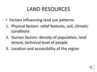
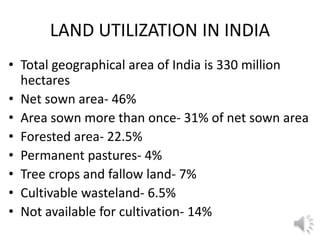
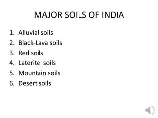
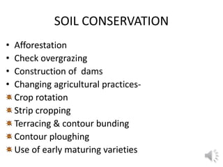
This document discusses land and soil resources in India. It notes that the total land area of India is 330 million hectares, of which 46% is net sown area and 22.5% is forested. Land use depends on factors like soil fertility, relief, water availability, and population needs. A proper land use plan can help conserve soils and forests by checking desert spread, adopting scientific techniques, providing irrigation, and increasing fertilizer use. The document also outlines the major soil types in India and techniques for soil conservation like afforestation, controlled grazing, and adjusted agricultural practices.
Development and rainfed paddy soils potency derived from lacustrine material ...NurdinUng
Rainfed paddy soils that are derived from lacustrine and include of E4 agroclimatic zone have many unique properties and potentially for paddy and corn plantations. This sreseach was aimed to: (1) study the soil development of
rainfed paddy soils derived from lacustrine and (2) evaluate rainfed paddy soils potency for paddy and corn in Paguyaman. Soil samples were taken from three profiles according to toposequent, and they were analyzed in laboratory. Data were analyzed with descriptive-quantitative analysis. Furthermore, assessment on rainfed paddy soils potency was conducted with land suitability analysis using parametric approach. Results indicate that all pedon had evolved with B horizons structurization. However, pedon located on the summit slope was more developed and intensely weathered than those of the shoulder and foot slopes.The main pedogenesis in all pedons were through
elluviation, illuviation, lessivage, pedoturbation, and gleization processes. The main factors of pedogenesis were climate, age (time) and topography factors. Therefore, P1 pedons are classified as Ustic Endoaquerts, fine, smectitic,
isohypertermic; P2 as Vertic Endoaquepts, fine, smectitic, isohypertermic; and P3 as Vertic Epiaquepts, fine, smectitic,
isohypertermic. Based on the potentials of the land, the highest of land suitability class (LSC) of land utilization type (LUT) local paddy was highly suitable (S1), while the lowest one was not suitable with nutrient availability as the limiting factor (Nna). The highest LCS of paddy-corn LUT was marginally suitable with water availability as the limiting factor (S3wa), while the lower LSC was not suitable with nutrient availabily as the limiting factor (Nna).
Assessment of Zinc and Copper Status of Fadama Soils In Borgu Local Governmen...Agriculture Journal IJOEAR
Abstract— The status of Zinc (Zn) and Copper (Cu) of fadama soils under cultivation at Borgu Local Government Area, Niger State, Nigeria was studied. Soil samples were purposely collected from three extension blocks, namely; Wawa, Babana and Goffanti. Particle size distribution of the soils showed sandy loam texture. The soils pH were either slightly acidic or neutral with a range between 6.05 and 6.93. The level of Organic Carbon (OC) ranged between low and medium, total nitrogen were rated high, available phosphorus were low while exchangeable cations (Na, K, Ca, Mg) were all rated high. Though soil content of Zn and Cu were very low, values were not significantly (P<0.05) different for all locations. The mean values for Zn ranged between 0.496 and 0.592 mg/kg, while Cu ranged between 0.550 and 0.945 mg/kg. This result implies that soil amendments in the form of organic manure and/or supplement of Zn and Cu would enhance nutrient availability for optimum yields of crops for the resource-poor farmers in the study area.
Indian agriculture is passing through difficult times due to erractic weather conditions, especially drought and excessive rainfall, there by resulting into wide spread distress among farmers.
The average income of an agricultural household during July 2012 to June 2013 was as low as Rs.6,426.
As many as 22.50% of the farmers live below poverty line, the country also witnessed a sharp increase in the number of farmers suicides due to losses from farming and low farm income.
Farming in India is becoming hard and unsuccessful due to several causes like unexpected rainfalls,droughts, increased cost of cultivation due to pests and diseases, decrease in productivity of land, unavailability of water etc..
Farmers get very low income for their produce due to prevailing market prices that are very unstable.
Decline in Agriculture productivity and Income has a serious effect on rural house holds, and other economic, social as well as sustainability indicators.
1 ijreh dec-2017-3-environmental and socio-economicAI Publications
The benefits of the use of biochar in improvement of soil properties and crop growth have been dominating scientific debates in efforts to include biochar in policy and regulatory frameworks. The study incorporated a semi participatory methodology involving farmers to gain anon-farm-view assessment of the challenges, environmental feasibility, economic profitability and socio-cultural soundness of biochar production and use. Biochar produced from cassava stems, ricehuskand corncobs using an Elsa pyrolyser were applied at 16kg/plot on 8m2 experimental plots during the 2016/2017 cropping season in Nkolbisson, Cameroon following a complete randomised design with three replications. Cassava plant growth parameters were measured at 3, 6 and 9 months after planting while yields were obtained at harvest. Cost benefit analysis was used to evaluate the total costs and revenue returns.Fifteen farmers participated in the trialand semi-structured questionnaires and interviews were used to elucidate farmer’s assessment of biochar. Results showed that, farmers using ricehusk biochar encured more profits with net benefits of 1.44 million fCFA andmarginal rate of return (33.06%) compared to thecontrol (583267fCFA) with MRR of 12.33% and corncob biochar (353436 fCFA) with MRR of 7.80%. Additional revenue (34.95%)was gained from the use of ricehusk biochar market price for CO2 offset at ($60).The use of ricehusk biochar was found to be socio-economically and environmentally feasible. However, national sensitization on biochar production could helpcreate awareness, generate a huge leap in livelihoods as well as get the attention of the government for policy drive.
Increasing rice productivity by manipulation of calcium fertilizer in ustic e...NurdinUng
National rice production needs to be improved and maintained to meet the demands of fast growing population. One of the ways to meet this demand is through cultivating the rain fed land in many areas which its physical characteristics are challenging factor. This research aims at finding out the feedback of the rice production on the calcium fertilizer following the administration of river sand, beach sand, coco peat, and banana peat in ustic endoaquert. This research is implemented in rain fed field composed of vertisol soil in Sidomukti village of Mootilango Gorontalo, Indonesia. The subjects are randomly chosen and the treatments are separately implemented in two sub-group of vertisol soil. There are five treatments that were repeated three times, thus, there are 15 pieces of trials in each sub-vertisol groups. This research reveals that the administration of K fertilizer following the administration of river sand, beach sands, coco peat, and banana trunks fiber has significant effect on the number of grain, the weight of 1000 grains and the total weight of the grains. Meanwhile, the administration of K fertilizer following the administration of beach sand, coco peat and banana peat has significantly influenced the number of stalk, the length of stalk, and the total weight of the grains.
Application of Remote Sensing Techniques for Mapping Shifting CultivationIJERA Editor
Shifting cultivation is an ancient and primitive method of cultivation, also referred to as ‘slash and burn’ or ‘rotational bush fallow agricultural system’. The practice mainly involves removal of the forests by primitive slash and burn technique followed by mixed cropping for short period before abandoning the site. Tribals all over India are known to follow the practice of shifting cultivation with some regional variations. The present study has been undertaken to estimate the spatial distribution of podu cultivation in Srikakulam district of Andhra Pradesh by using remote sensing techniques. Results of the present study indicate that an estimated area of 10,491.857 acres of the forest area is under shifting cultivation in Srikakulam district. Shifting cultivation has caused a great deal of environmental degradation. Remote sensing techniques with repetitive coverage and synoptic view provide database for assessing environment degrading practices. Mapping of shifting areas is important not only from ecological point of view but also for management purposes.
Monitoring Of Water Logged Areas in Krishana Canal Command Using Gis TechniquesIJERA Editor
Degradation of land due to waterlogging in sugarcane track of western Maharashtra is a serious problem. Here researchers had understood the problem of the waterlogged areas by preparing an inventory using GIS and GPS techniques. Krishna Canal Command area is lies in Satara and Sangli districts. Total length of canal is 86 km, out of which 21 km length is comes under study area. The command area is divided in 4 segments, out of which, the present study deals with Segment IV. Water table map was prepared using water depth data at 231 well locations. The entire analysis was carried out in ArcGIS software. GIS – Spatial Analysis tool, point data was rasterised, and surfaces for water table were generated. Risk zonation maps were prepared using the critical limits given by IRD, Pune. Water table surface was intersected with village boundary layers. Risk zonation map of water table suggests that the two villages namely Nagral and Burli situated close to canal are most vulnerable due to high water table. Almost 36 % of the total study area of land covering partially the villages Nagral, Burli, Shirasgaon, Amnapur, Palus, and Yelavi were found under critical water table condition. In segment IV total area of 792 ha in villages Nagral, Burli, Amnapur, Yelavi, and Bhilawadi fall under the P1 category affected most badly by the waterlogging condition. Prioritization of villages based on AWI suggests that out of the total eight villages, five villages namely Amnapur, Burli, Bhilawadi, Nagral and Yelavi are falling under P1 priority category, need immediate attention for remedial measures
Welcome to International Journal of Engineering Research and Development (IJERD)IJERD Editor
journal publishing, how to publish research paper, Call For research paper, international journal, publishing a paper, IJERD, journal of science and technology, how to get a research paper published, publishing a paper, publishing of journal, publishing of research paper, reserach and review articles, IJERD Journal, How to publish your research paper, publish research paper, open access engineering journal, Engineering journal, Mathemetics journal, Physics journal, Chemistry journal, Computer Engineering, Computer Science journal, how to submit your paper, peer reviw journal, indexed journal, reserach and review articles, engineering journal, www.ijerd.com, research journals,
yahoo journals, bing journals, International Journal of Engineering Research and Development, google journals, hard copy of journal
Conservation agriculture useful for meeting future food demands and also contributing to sustainable agriculture.
Conservation agriculture helps to minimizing the negative environmental effect and equally important to increased income to help the livelihood of those employed in agril. Production.
Introduction of conservation technologies (CT) was an important break through for sustaining productivity, It seeks to conserve, improve and make more efficient use of natural resources through integrated management of soil, water, crops and other biological resources in combination with selected external inputs.
First meeting of the Editorial Board of the Soil Atlas of Asia, 12 - 15 March 2018, Quezon City, Philippines. The preparation of the Soil Atlas of Asia is sponsored by Joint Research Centre of the European Commission (JRC-EC).
An exploratory study on farmer’s vernacular knowledge about the land characte...Agriculture Journal IJOEAR
Local people and small scale farmer had a broad understanding of their land characteristics and soil quality to choose crop. Though Maximum farmers in our country are illiterate and little educated; they have no enough scientific knowledge about land type, soil quality and crop suitability. But they possess vast indigenous knowledge by living in a same environment for a long period of time. They have developed some strategies that helped them to attain a higher degree of satisfaction in farming. So therefore it is very important to explore the farmer's vernacular knowledge about the land type, soil quality and crop suitability. To address this indigenous knowledge this study investigates the farmer's vernacular knowledge about the land type, soil quality and crop suitability in Lower Ganga Flood Plain in Bangladesh. The information was collected from one Mouza in Nagarkanda upazila, Faridpur district Lower Ganga Flood Plain in Bangladesh. Qualitative and quantitative both data were used in this study. The data were collected from primary sources (such as questionnaire survey, FGD) and secondary data sources (such as books, journals, and published and unpublished research reports). Data were analyzed by exploratory statistics. Graphs and graph tables were created by MS excel. By analyzing the Field data it was investigated that farmers of the study area recognized four elevation levels of land; i). High Land (Vitta) ii). Medium Land (Taner Jomi) iii). Low Land (Nall/Dhop) iv).Very Low (Beel) based on its elevation, flood depth, land use, and crop suitability. The farmers of the study area possess considerable knowledge of the soils quality, moisture conditions of that area. The farmers of the study area distinguish soil into three categories primarily on the basis of color, texture, organic matter content, drainage, and fertility of soils. They use indigenous methods such as visual observation while color, tasting by tongue, feeling, vegetation cover and rubbing with fingers to determine various soil properties. Thus Farmers' knowledge of soils is, therefore, a vast resource we summarized in this paper.
The layout or arrangement of the uses of the land is known as "land use pattern". The land may be used for agriculture, forest, pasture etc. Land use is determined by many factors like relief features, climate, soil, density of population, technical and socio- economic factors.Out of India's total geographical area of 328.7 million hectares, the statistical information about the land use pattern in India is available for only about 305.69 million hectares. It is based on village papers and on estimates. The land use has changed drastically since 1950-51.
Natural resources conservation is a process of rational use and skillful management and preservation of the natural environment with all its resources. Natural resources are finite, limited, and capable of being destroyed by unsustainable use and this can be a limiting factor on sustainable development.
Land is a basic natural resource, significantly contributing to a nation’s economy. Balances the Ecological and environmental factors to sustain all life. Economic resource-has a value as property. Most of the human activities are on lands. Land supports agriculture, transport, urbanization, etc. Encompasses all other natural resources, like water, oil, rocks, plants, animals and minerals. Land is a valuable natural resource utilized for cultivation of crops, settlements of population, creation of Dams and reservoirs, development of industries and maintaining forests and the Wildlife. India has divers range of landforms. They vary from the rainforest of Kerala in the south to the alpine pastures of Ladakh hills in the north, from the deserts of Rajasthan in the west to the evergreen forests in the north-east. Any kind of permanent or cyclic intervention of a land is called as landuse. It is the surface utilization of a vacant land or a developed land for a clear purpose, at a given time.
Model Attribute Check Company Auto PropertyCeline George
In Odoo, the multi-company feature allows you to manage multiple companies within a single Odoo database instance. Each company can have its own configurations while still sharing common resources such as products, customers, and suppliers.
The French Revolution, which began in 1789, was a period of radical social and political upheaval in France. It marked the decline of absolute monarchies, the rise of secular and democratic republics, and the eventual rise of Napoleon Bonaparte. This revolutionary period is crucial in understanding the transition from feudalism to modernity in Europe.
For more information, visit-www.vavaclasses.com
Embracing GenAI - A Strategic ImperativePeter Windle
Artificial Intelligence (AI) technologies such as Generative AI, Image Generators and Large Language Models have had a dramatic impact on teaching, learning and assessment over the past 18 months. The most immediate threat AI posed was to Academic Integrity with Higher Education Institutes (HEIs) focusing their efforts on combating the use of GenAI in assessment. Guidelines were developed for staff and students, policies put in place too. Innovative educators have forged paths in the use of Generative AI for teaching, learning and assessments leading to pockets of transformation springing up across HEIs, often with little or no top-down guidance, support or direction.
This Gasta posits a strategic approach to integrating AI into HEIs to prepare staff, students and the curriculum for an evolving world and workplace. We will highlight the advantages of working with these technologies beyond the realm of teaching, learning and assessment by considering prompt engineering skills, industry impact, curriculum changes, and the need for staff upskilling. In contrast, not engaging strategically with Generative AI poses risks, including falling behind peers, missed opportunities and failing to ensure our graduates remain employable. The rapid evolution of AI technologies necessitates a proactive and strategic approach if we are to remain relevant.
June 3, 2024 Anti-Semitism Letter Sent to MIT President Kornbluth and MIT Cor...Levi Shapiro
Letter from the Congress of the United States regarding Anti-Semitism sent June 3rd to MIT President Sally Kornbluth, MIT Corp Chair, Mark Gorenberg
Dear Dr. Kornbluth and Mr. Gorenberg,
The US House of Representatives is deeply concerned by ongoing and pervasive acts of antisemitic
harassment and intimidation at the Massachusetts Institute of Technology (MIT). Failing to act decisively to ensure a safe learning environment for all students would be a grave dereliction of your responsibilities as President of MIT and Chair of the MIT Corporation.
This Congress will not stand idly by and allow an environment hostile to Jewish students to persist. The House believes that your institution is in violation of Title VI of the Civil Rights Act, and the inability or
unwillingness to rectify this violation through action requires accountability.
Postsecondary education is a unique opportunity for students to learn and have their ideas and beliefs challenged. However, universities receiving hundreds of millions of federal funds annually have denied
students that opportunity and have been hijacked to become venues for the promotion of terrorism, antisemitic harassment and intimidation, unlawful encampments, and in some cases, assaults and riots.
The House of Representatives will not countenance the use of federal funds to indoctrinate students into hateful, antisemitic, anti-American supporters of terrorism. Investigations into campus antisemitism by the Committee on Education and the Workforce and the Committee on Ways and Means have been expanded into a Congress-wide probe across all relevant jurisdictions to address this national crisis. The undersigned Committees will conduct oversight into the use of federal funds at MIT and its learning environment under authorities granted to each Committee.
• The Committee on Education and the Workforce has been investigating your institution since December 7, 2023. The Committee has broad jurisdiction over postsecondary education, including its compliance with Title VI of the Civil Rights Act, campus safety concerns over disruptions to the learning environment, and the awarding of federal student aid under the Higher Education Act.
• The Committee on Oversight and Accountability is investigating the sources of funding and other support flowing to groups espousing pro-Hamas propaganda and engaged in antisemitic harassment and intimidation of students. The Committee on Oversight and Accountability is the principal oversight committee of the US House of Representatives and has broad authority to investigate “any matter” at “any time” under House Rule X.
• The Committee on Ways and Means has been investigating several universities since November 15, 2023, when the Committee held a hearing entitled From Ivory Towers to Dark Corners: Investigating the Nexus Between Antisemitism, Tax-Exempt Universities, and Terror Financing. The Committee followed the hearing with letters to those institutions on January 10, 202
Instructions for Submissions thorugh G- Classroom.pptxJheel Barad
This presentation provides a briefing on how to upload submissions and documents in Google Classroom. It was prepared as part of an orientation for new Sainik School in-service teacher trainees. As a training officer, my goal is to ensure that you are comfortable and proficient with this essential tool for managing assignments and fostering student engagement.
2. LAND RESOURCES
• Factors influencing land use patterns-
1. Physical factors- relief features, soil, climatic
conditions
2. Human factors- density of population, land
tenure, technical level of people
3. Location and accessibility of the region
3. LAND UTILIZATION IN INDIA
• Total geographical area of India is 330 million
hectares
• Net sown area- 46%
• Area sown more than once- 31% of net sown area
• Forested area- 22.5%
• Permanent pastures- 4%
• Tree crops and fallow land- 7%
• Cultivable wasteland- 6.5%
• Not available for cultivation- 14%
4. LAND CULTIVATION
• It depends on –
1. Fertility of soil
2. Relief of land
3. Availability of water
4. Need of the people
5. PREPARING LAND USE PLAN
Proper land use plan can be prepared by-
Checking the further spread of deserts
Adopting scientific techniques
Conserving soils and forests
Providing irrigation facilities
Increasing the use of manures and chemical
fertilizers
6. SOIL RESOURCES
• Soil is the thin surface layer of the earth formed
by breaking of rocks, decayed organic matter,
living organisms, water and air
• Organic elements- humus,
• Inorganic elements- nitrogen, potassium, sulphur,
phosphorus, calcium, iron etc.