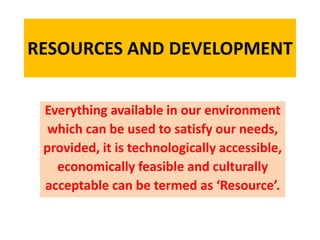
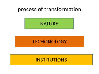
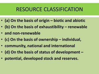
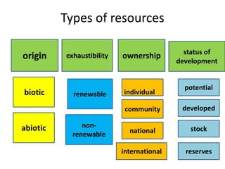
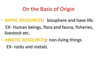
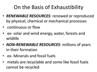
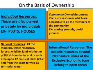
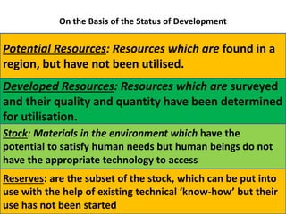
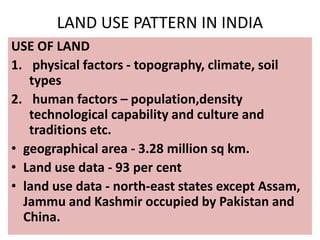
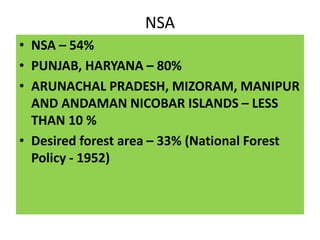
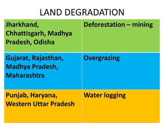
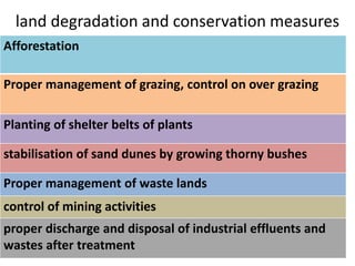
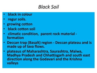
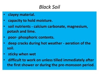
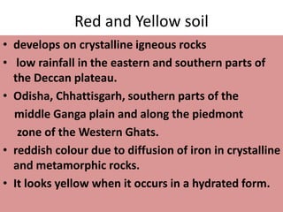
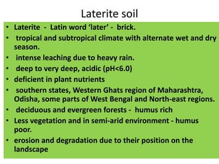
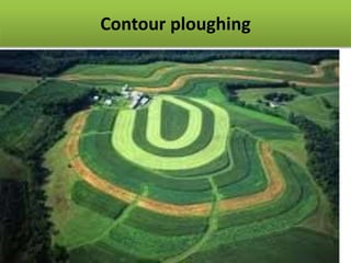
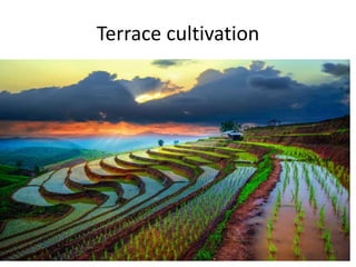
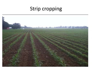
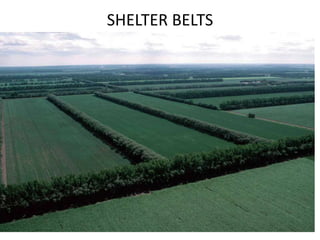
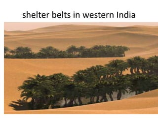
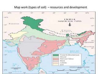
RESOURCES AND DEVELOPMENT
Everything available in our environment
which can be used to satisfy our needs,
provided, it is technologically accessible,
economically feasible and culturally
acceptable can be termed as ‘Resource’.
process of transformation
NATURE
TECHONOLOGY
INSTITUTIONS
RESOURCE CLASSIFICATION
• (a) On the basis of origin – biotic and abiotic
• (b) On the basis of exhaustibility – renewable
• and non-renewable
• (c) On the basis of ownership – individual,
• community, national and international
• (d) On the basis of status of development –
• potential, developed stock and reserves.
Types of resources
origin exhaustibility ownership status of
development
biotic
abiotic non-
renewable
renewable
national
community
individual
potential
developed
stock
reserves
international
On the Basis of Origin
• BIOTIC RESOURCES: biosphere and have life.
EX- Human beings, flora and fauna, fisheries,
livestock etc.
• ABIOTIC RESOURCES: non-living things
EX- rocks and metals.
On the Basis of Exhaustibility
• RENEWABLE RESOURCES: renewed or reproduced
by physical, chemical or mechanical processes
• continuous or flow
• ex- solar and wind energy, water, forests and
wildlife
• NON-RENEWABLE RESOURCES: millions of years
in their formation
• ex- Minerals and fossil fuels
• metals are recyclable and some like fossil fuels
cannot be recycled
On the Basis of Ownership
Individual Resources:
These are also owned
privately by individuals.
EX- PLOTS, HOUSES
Community Owned Resources:
There are resources which are
accessible to all the members of
the community.
EX- grazing grounds, burial
grounds
National resources: All the
minerals, water resources,
forests, wildlife, land within the
political boundaries and oceanic
area up to 12 nautical miles (22.2
km) from the coast termed as
territorial water
International Resources: The
oceanic resources beyond
200 nautical miles of the
Exclusive Economic Zone
belong to open ocean
On the Basis of the Status of Development
Potential Resources: Resources which are found in a
region, but have not been utilised.
Developed Resources: Resources which are surveyed
and their quality and quantity have been determined
for utilisation.
Stock: Materials in the environment which have the
potential to satisfy human needs but human beings do not
have the appropriate technology to access
Reserves: are the subset of the stock, which can be put into
use with the help of existing technical ‘know-how’ but their
use has not been started
Indiscriminate use of resources
• Depletion of resources for satisfying the greed of a
few individuals.
• Accumulation of resources in few hands, which, in
turn, divided the society into two segments i.e.
haves and have nots or rich and poor
• Indiscriminate exploitation of resources has led to
global ecological crises such as, global warming,
ozone layer depletion, environmental pollution
and land degradation
Sustainable development
• development should take place
• without damaging the environment
• and development in the present
• should not compromise with the
needs of the future generations.
Rio de Janeiro Earth Summit, 1992
• June 1992
• 100 heads of states
• Rio de Janeiro in Brazil
• for the first International Earth Summit.
• problems of environmental protection and
socioeconomic development
• signed the Declaration on Global Climatic Change
and Biological Diversity.
• global Forest Principles
• Agenda 21 for achieving Sustainable Development
in the 21st century.
Agenda 21
• declaration signed in 1992 at the United
Nations Conference on Environment and
Development (UNCED),
• global sustainable development.
• agenda - environmental damage, poverty,
disease
• major objective - Agenda 21 is that every local
government should draw its own local Agenda
21.
Resource Planning
place rich Deficient
Jharkhand,
Chhattisgarh, Madhya
Pradesh
Minerals and coal
deposits
Arunachal pradesh water infrastructural
development
Rajasthan Solar and wind
energy
water
Ladakh
Cultural heritage
Water, infrastructure,
minerals
Resource Planning in India
(i) identification and inventory of resources across
the regions of the country. This involves surveying,
mapping and qualitative and quantitative
estimation and measurement of the resources.
(ii) Evolving a planning structure endowed with
appropriate technology, skill and institutional set
up for implementing resource development plans.
(iii) Matching the resource development plans with
overall national development plans.
Resource Planning in India
• Resource planning – from first five year plan
• Availability of resources
• Technology
• Institutions
• It was primarily the higher level of
technological development of the colonising
countries that helped them to exploit
resources of other regions and establish their
supremacy over the colonies.
Conservation of Resources
Gandhiji
• There is enough for everybody’s need and not
for any body’s greed.”
• modern technology as the root cause for
resource depletion at the global level.
• He was against mass production and wanted to
replace it with the production by the masses.
Conservation of Resources
The Club of Rome -
resource conservation -
1968.
1974, Gandhian
philosophy - Schumacher
- Small is Beautiful.
Resource conservation-
Brundtland Commission
Report, 1987 -‘Sustainable
Development’ - book - Our
Common Future.
Earth Summit at Rio de
Janeiro, Brazil in 1992.
LAND RESOURCES
43%
30%
27%
PLAINS
MOUNTAINS
PLATEAUS
LAND UTILISATION
Land resources are used for the following purposes:
1. Forests
2. Land not available for cultivation
(a) Barren and waste land
(b) Land put to non-agricultural uses, e.g. buildings,
roads, factories, etc.
3. Other uncultivated land (excluding fallow land)
(a) Permanent pastures and grazing land,
(b) Land under miscellaneous tree crops groves (not
included in net sown area),
(c) Cultruable waste land (left uncultivated for more
than 5 agricultural years).
4. Fallow lands
(a) Current fallow-(left without cultivation
for one or less than one agricultural year),
(b) Other than current fallow-(left
uncultivated for the past 1 to 5 agricultural
years).
5. Net sown area
Area sown more than once in an agricultural
year plus net sown area is known as gross
cropped area.
LAND USE PATTERN IN INDIA
USE OF LAND
1. physical factors - topography, climate, soil
types
2. human factors – population,density
technological capability and culture and
traditions etc.
• geographical area - 3.28 million sq km.
• Land use data - 93 per cent
• land use data - north-east states except Assam,
Jammu and Kashmir occupied by Pakistan and
China.
NSA
• NSA – 54%
• PUNJAB, HARYANA – 80%
• ARUNACHAL PRADESH, MIZORAM, MANIPUR
AND ANDAMAN NICOBAR ISLANDS – LESS
THAN 10 %
• Desired forest area – 33% (National Forest
Policy - 1952)
LAND DEGRADATION
Jharkhand,
Chhattisgarh, Madhya
Pradesh, Odisha
Deforestation – mining
Gujarat, Rajasthan,
Madhya Pradesh,
Maharashtra
Overgrazing
Punjab, Haryana,
Western Uttar Pradesh
Water logging
land degradation and conservation measures
Afforestation
Proper management of grazing, control on over grazing
Planting of shelter belts of plants
stabilisation of sand dunes by growing thorny bushes
Proper management of waste lands
control of mining activities
proper discharge and disposal of industrial effluents and
wastes after treatment
SOIL AS A RESOURCE
It is the medium of plant
growth and supports
different types of living
organisms on the earth.
• Relief
• parent rock or bed rock,
• Climate
• vegetation and other
forms of life
• time
FORCES OF NATURE
• change in temperature,
• actions of running water,
• wind
• glaciers,
• activities of
decomposers
• Chemical and organic
changes
Alluvial Soil
• most widely spread
• northern plains - alluvial soil.
• deposited by Himalayan river – the Indus, the
Ganga and the Brahmaputra. (BIG)
• Rajasthan and Gujarat through a narrow
corridor.
• Eastern coastal plains – deltas of the
Mahanadi, the Godavari, the Krishna and the
Kaveri rivers.
Gujarat,
Rajasthan
Eastern coastal
plains
Alluvial Soil
• sand, silt and clay.
• Inland - river valleys -
soil - bigger in size.
• upper reaches of the
river valley - coarse.
• piedmont plains
such as Duars, Chos
and Terai.
Alluvial Soil
Age - old alluvial (Bangar) higher concentration of kanker
nodules
New alluvial (Khadar)fine particles and is more fertile
very fertile - intensively cultivated and densely
populated
potash, phosphoric acid and lime
sugarcane, paddy, wheat and other cereal and
pulse crops
drier areas - alkaline - proper treatment and
irrigation.
Black Soil
• black in colour
• regur soils.
• growing cotton
• black cotton soil
• climatic condition, parent rock material -
formation
• Deccan trap (Basalt) region - Deccan plateau and is
made up of lava flows.
• plateaus of Maharashtra, Saurashtra, Malwa,
Madhya Pradesh and Chhattisgarh and south east
direction along the Godavari and the Krishna
valleys
Black Soil
• clayey material.
• capacity to hold moisture.
• soil nutrients - calcium carbonate, magnesium,
potash and lime.
• poor- phosphoric contents.
• deep cracks during hot weather - aeration of the
soil.
• sticky when wet
• difficult to work on unless tilled immediately after
the first shower or during the pre-monsoon period.
Red and Yellow soil
• develops on crystalline igneous rocks
• low rainfall in the eastern and southern parts of
the Deccan plateau.
• Odisha, Chhattisgarh, southern parts of the
middle Ganga plain and along the piedmont
zone of the Western Ghats.
• reddish colour due to diffusion of iron in crystalline
and metamorphic rocks.
• It looks yellow when it occurs in a hydrated form.
Laterite soil
• Laterite - Latin word ‘later’ - brick.
• tropical and subtropical climate with alternate wet and dry
season.
• intense leaching due to heavy rain.
• deep to very deep, acidic (pH<6.0)
• deficient in plant nutrients
• southern states, Western Ghats region of Maharashtra,
Odisha, some parts of West Bengal and North-east regions.
• deciduous and evergreen forests - humus rich
• Less vegetation and in semi-arid environment - humus
poor.
• erosion and degradation due to their position on the
landscape
Laterite soil
• With soil conservation techniques particularly in
the hilly areas of Karnataka, Kerala and
Tamil Nadu, this soil is very useful for growing
tea and coffee.
• Red laterite soils in Tamil Nadu, Andhra Pradesh
and Kerala are more suitable for crops like cashew
nut.
Arid soil
• red to brown in colour.
• sandy in texture and saline in nature.
• common salt - evaporating the water.
• dry climate, high temperature, evaporation
is faster and the soil lacks humus and
moisture.
• The Kankar layer - bottom horizons - restrict
the infiltration of water.
• proper irrigation - western Rajasthan
6. Forest soils
• found in the hilly and mountainous areas
• texture - mountain environment
• loamy and silty - valley sides
• coarse grained - upper slopes.
• Himalayas - soil denudation and are acidic
with low humus
The soils found in the lower parts of the valleys
particularly on the river terraces and alluvial fans are
fertile
SOIL EROSION AND SOIL CONSERVATION
• The denudation of the soil cover and
subsequent washing down is described as
soil erosion
• Human - deforestation, over-grazing,
construction and mining etc
• natural - wind, glacier and water
• The running water cuts through the
clayey soils and makes deep
channels as gullies.
• The land becomes unfit for
cultivation and is known as bad
land.
• In the Chambal basin such lands are
called ravines.
GULLIES
CHAMBAL - RAVINES
water flows over large areas, soil is washed away.
This is known as sheet erosion
Contour ploughing
Terrace cultivation
Strip cropping
SHELTER BELTS
shelter belts in western India
Map work (types of soil) – resources and development

G-10, PPT RESOURCES AND DEVELOPMENT (2).pptx

  • 1.
    RESOURCES AND DEVELOPMENT Everythingavailable in our environment which can be used to satisfy our needs, provided, it is technologically accessible, economically feasible and culturally acceptable can be termed as ‘Resource’.
  • 2.
  • 3.
    RESOURCE CLASSIFICATION • (a)On the basis of origin – biotic and abiotic • (b) On the basis of exhaustibility – renewable • and non-renewable • (c) On the basis of ownership – individual, • community, national and international • (d) On the basis of status of development – • potential, developed stock and reserves.
  • 4.
    Types of resources originexhaustibility ownership status of development biotic abiotic non- renewable renewable national community individual potential developed stock reserves international
  • 5.
    On the Basisof Origin • BIOTIC RESOURCES: biosphere and have life. EX- Human beings, flora and fauna, fisheries, livestock etc. • ABIOTIC RESOURCES: non-living things EX- rocks and metals.
  • 6.
    On the Basisof Exhaustibility • RENEWABLE RESOURCES: renewed or reproduced by physical, chemical or mechanical processes • continuous or flow • ex- solar and wind energy, water, forests and wildlife • NON-RENEWABLE RESOURCES: millions of years in their formation • ex- Minerals and fossil fuels • metals are recyclable and some like fossil fuels cannot be recycled
  • 7.
    On the Basisof Ownership Individual Resources: These are also owned privately by individuals. EX- PLOTS, HOUSES Community Owned Resources: There are resources which are accessible to all the members of the community. EX- grazing grounds, burial grounds National resources: All the minerals, water resources, forests, wildlife, land within the political boundaries and oceanic area up to 12 nautical miles (22.2 km) from the coast termed as territorial water International Resources: The oceanic resources beyond 200 nautical miles of the Exclusive Economic Zone belong to open ocean
  • 8.
    On the Basisof the Status of Development Potential Resources: Resources which are found in a region, but have not been utilised. Developed Resources: Resources which are surveyed and their quality and quantity have been determined for utilisation. Stock: Materials in the environment which have the potential to satisfy human needs but human beings do not have the appropriate technology to access Reserves: are the subset of the stock, which can be put into use with the help of existing technical ‘know-how’ but their use has not been started
  • 9.
    Indiscriminate use ofresources • Depletion of resources for satisfying the greed of a few individuals. • Accumulation of resources in few hands, which, in turn, divided the society into two segments i.e. haves and have nots or rich and poor • Indiscriminate exploitation of resources has led to global ecological crises such as, global warming, ozone layer depletion, environmental pollution and land degradation
  • 10.
    Sustainable development • developmentshould take place • without damaging the environment • and development in the present • should not compromise with the needs of the future generations.
  • 11.
    Rio de JaneiroEarth Summit, 1992 • June 1992 • 100 heads of states • Rio de Janeiro in Brazil • for the first International Earth Summit. • problems of environmental protection and socioeconomic development • signed the Declaration on Global Climatic Change and Biological Diversity. • global Forest Principles • Agenda 21 for achieving Sustainable Development in the 21st century.
  • 12.
    Agenda 21 • declarationsigned in 1992 at the United Nations Conference on Environment and Development (UNCED), • global sustainable development. • agenda - environmental damage, poverty, disease • major objective - Agenda 21 is that every local government should draw its own local Agenda 21.
  • 13.
    Resource Planning place richDeficient Jharkhand, Chhattisgarh, Madhya Pradesh Minerals and coal deposits Arunachal pradesh water infrastructural development Rajasthan Solar and wind energy water Ladakh Cultural heritage Water, infrastructure, minerals
  • 14.
    Resource Planning inIndia (i) identification and inventory of resources across the regions of the country. This involves surveying, mapping and qualitative and quantitative estimation and measurement of the resources. (ii) Evolving a planning structure endowed with appropriate technology, skill and institutional set up for implementing resource development plans. (iii) Matching the resource development plans with overall national development plans.
  • 15.
    Resource Planning inIndia • Resource planning – from first five year plan • Availability of resources • Technology • Institutions • It was primarily the higher level of technological development of the colonising countries that helped them to exploit resources of other regions and establish their supremacy over the colonies.
  • 16.
    Conservation of Resources Gandhiji •There is enough for everybody’s need and not for any body’s greed.” • modern technology as the root cause for resource depletion at the global level. • He was against mass production and wanted to replace it with the production by the masses.
  • 17.
    Conservation of Resources TheClub of Rome - resource conservation - 1968. 1974, Gandhian philosophy - Schumacher - Small is Beautiful. Resource conservation- Brundtland Commission Report, 1987 -‘Sustainable Development’ - book - Our Common Future. Earth Summit at Rio de Janeiro, Brazil in 1992.
  • 18.
  • 19.
    LAND UTILISATION Land resourcesare used for the following purposes: 1. Forests 2. Land not available for cultivation (a) Barren and waste land (b) Land put to non-agricultural uses, e.g. buildings, roads, factories, etc. 3. Other uncultivated land (excluding fallow land) (a) Permanent pastures and grazing land, (b) Land under miscellaneous tree crops groves (not included in net sown area), (c) Cultruable waste land (left uncultivated for more than 5 agricultural years).
  • 20.
    4. Fallow lands (a)Current fallow-(left without cultivation for one or less than one agricultural year), (b) Other than current fallow-(left uncultivated for the past 1 to 5 agricultural years). 5. Net sown area Area sown more than once in an agricultural year plus net sown area is known as gross cropped area.
  • 21.
    LAND USE PATTERNIN INDIA USE OF LAND 1. physical factors - topography, climate, soil types 2. human factors – population,density technological capability and culture and traditions etc. • geographical area - 3.28 million sq km. • Land use data - 93 per cent • land use data - north-east states except Assam, Jammu and Kashmir occupied by Pakistan and China.
  • 22.
    NSA • NSA –54% • PUNJAB, HARYANA – 80% • ARUNACHAL PRADESH, MIZORAM, MANIPUR AND ANDAMAN NICOBAR ISLANDS – LESS THAN 10 % • Desired forest area – 33% (National Forest Policy - 1952)
  • 23.
    LAND DEGRADATION Jharkhand, Chhattisgarh, Madhya Pradesh,Odisha Deforestation – mining Gujarat, Rajasthan, Madhya Pradesh, Maharashtra Overgrazing Punjab, Haryana, Western Uttar Pradesh Water logging
  • 24.
    land degradation andconservation measures Afforestation Proper management of grazing, control on over grazing Planting of shelter belts of plants stabilisation of sand dunes by growing thorny bushes Proper management of waste lands control of mining activities proper discharge and disposal of industrial effluents and wastes after treatment
  • 25.
    SOIL AS ARESOURCE It is the medium of plant growth and supports different types of living organisms on the earth. • Relief • parent rock or bed rock, • Climate • vegetation and other forms of life • time FORCES OF NATURE • change in temperature, • actions of running water, • wind • glaciers, • activities of decomposers • Chemical and organic changes
  • 26.
    Alluvial Soil • mostwidely spread • northern plains - alluvial soil. • deposited by Himalayan river – the Indus, the Ganga and the Brahmaputra. (BIG) • Rajasthan and Gujarat through a narrow corridor. • Eastern coastal plains – deltas of the Mahanadi, the Godavari, the Krishna and the Kaveri rivers.
  • 27.
  • 28.
    Alluvial Soil • sand,silt and clay. • Inland - river valleys - soil - bigger in size. • upper reaches of the river valley - coarse. • piedmont plains such as Duars, Chos and Terai.
  • 29.
    Alluvial Soil Age -old alluvial (Bangar) higher concentration of kanker nodules New alluvial (Khadar)fine particles and is more fertile very fertile - intensively cultivated and densely populated potash, phosphoric acid and lime sugarcane, paddy, wheat and other cereal and pulse crops drier areas - alkaline - proper treatment and irrigation.
  • 30.
    Black Soil • blackin colour • regur soils. • growing cotton • black cotton soil • climatic condition, parent rock material - formation • Deccan trap (Basalt) region - Deccan plateau and is made up of lava flows. • plateaus of Maharashtra, Saurashtra, Malwa, Madhya Pradesh and Chhattisgarh and south east direction along the Godavari and the Krishna valleys
  • 31.
    Black Soil • clayeymaterial. • capacity to hold moisture. • soil nutrients - calcium carbonate, magnesium, potash and lime. • poor- phosphoric contents. • deep cracks during hot weather - aeration of the soil. • sticky when wet • difficult to work on unless tilled immediately after the first shower or during the pre-monsoon period.
  • 32.
    Red and Yellowsoil • develops on crystalline igneous rocks • low rainfall in the eastern and southern parts of the Deccan plateau. • Odisha, Chhattisgarh, southern parts of the middle Ganga plain and along the piedmont zone of the Western Ghats. • reddish colour due to diffusion of iron in crystalline and metamorphic rocks. • It looks yellow when it occurs in a hydrated form.
  • 33.
    Laterite soil • Laterite- Latin word ‘later’ - brick. • tropical and subtropical climate with alternate wet and dry season. • intense leaching due to heavy rain. • deep to very deep, acidic (pH<6.0) • deficient in plant nutrients • southern states, Western Ghats region of Maharashtra, Odisha, some parts of West Bengal and North-east regions. • deciduous and evergreen forests - humus rich • Less vegetation and in semi-arid environment - humus poor. • erosion and degradation due to their position on the landscape
  • 34.
    Laterite soil • Withsoil conservation techniques particularly in the hilly areas of Karnataka, Kerala and Tamil Nadu, this soil is very useful for growing tea and coffee. • Red laterite soils in Tamil Nadu, Andhra Pradesh and Kerala are more suitable for crops like cashew nut.
  • 35.
    Arid soil • redto brown in colour. • sandy in texture and saline in nature. • common salt - evaporating the water. • dry climate, high temperature, evaporation is faster and the soil lacks humus and moisture. • The Kankar layer - bottom horizons - restrict the infiltration of water. • proper irrigation - western Rajasthan
  • 36.
    6. Forest soils •found in the hilly and mountainous areas • texture - mountain environment • loamy and silty - valley sides • coarse grained - upper slopes. • Himalayas - soil denudation and are acidic with low humus
  • 37.
    The soils foundin the lower parts of the valleys particularly on the river terraces and alluvial fans are fertile
  • 38.
    SOIL EROSION ANDSOIL CONSERVATION • The denudation of the soil cover and subsequent washing down is described as soil erosion • Human - deforestation, over-grazing, construction and mining etc • natural - wind, glacier and water
  • 39.
    • The runningwater cuts through the clayey soils and makes deep channels as gullies. • The land becomes unfit for cultivation and is known as bad land. • In the Chambal basin such lands are called ravines.
  • 40.
  • 41.
  • 42.
    water flows overlarge areas, soil is washed away. This is known as sheet erosion
  • 43.
  • 44.
  • 45.
  • 46.
  • 47.
    shelter belts inwestern India
  • 48.
    Map work (typesof soil) – resources and development