SlideShare a Scribd company logo
Dr. Santosh Bhailume. Int. Journal of Engineering Research and Application www.ijera.com
ISSN: 2248-9622, Vol. 6, Issue 9, (Part -3) September 2016, pp.46-49
www.ijera.com 46|P a g e
Monitoring Of Water Logged Areas in Krishana Canal
Command Using Gis Techniques
Dr. Santosh Bhailume 1
, Dr. Vasant Wagh2
Dr. Ravi Kumar3
1
Assistant Professor, Department of Geography, KVN Naik College, Nashik.
2
Associate Professor and Head, Department of Physics, KVN Naik College, Nashik.
3
Research Scholar, Himachal Pradesh University, Shimla
ABSTRACT
Degradation of land due to waterlogging in sugarcane track of western Maharashtra is a serious problem. Here
researchers had understood the problem of the waterlogged areas by preparing an inventory using GIS and GPS
techniques. Krishna Canal Command area is lies in Satara and Sangli districts. Total length of canal is 86 km,
out of which 21 km length is comes under study area. The command area is divided in 4 segments, out of which,
the present study deals with Segment IV. Water table map was prepared using water depth data at 231 well
locations. The entire analysis was carried out in ArcGIS software.
GIS – Spatial Analysis tool, point data was rasterised, and surfaces for water table were generated. Risk
zonation maps were prepared using the critical limits given by IRD, Pune. Water table surface was intersected
with village boundary layers. Risk zonation map of water table suggests that the two villages namely Nagral and
Burli situated close to canal are most vulnerable due to high water table. Almost 36 % of the total study area of
land covering partially the villages Nagral, Burli, Shirasgaon, Amnapur, Palus, and Yelavi were found under
critical water table condition. In segment IV total area of 792 ha in villages Nagral, Burli, Amnapur, Yelavi, and
Bhilawadi fall under the P1 category affected most badly by the waterlogging condition. Prioritization of
villages based on AWI suggests that out of the total eight villages, five villages namely Amnapur, Burli,
Bhilawadi, Nagral and Yelavi are falling under P1 priority category, need immediate attention for remedial
measures.
Keywords: Risk Zonation, Priority index, GIS, GPS, Remote Sensig, Non-spatial Data, Overlay Analysis
I. INTRODUCTION
India is home to billion people, 70% of
which directly or indirectly associated with
agriculture. None the less, agriculture is a back
bone of Indian economy. The share of agriculture
to the Gross Domestic Product (GDP) is around
28%, also 67% of employment comes from
agriculture. Since Independence, India has
experienced numerous spans of food shortage,
attributed to drought and famines. During the
sixties of the present century, scientist came out
with an idea of “Green Revolution” with a view to
achieve increase in agriculture productivity. Green
Revolution is characterized by farm mechanization,
provision of water through irrigation, introduction
of HIV’s (High Yielding Varieties), use of
pesticides and insecticides, etc. But every action
has its reaction. Due to over irrigation, many areas
now facing the problems of water logging and
salinisation.
Irrigation is lifeline for many arid and
semi-arid lands throughout the world. Mineral
richness of the soils in these regions virtually
assures good crops when irrigation is utilized.
Irrigation in excess is hazardous because the
waterlogged condition shuts off oxygen supply and
cripples the plant growth as well as develops
salinity in the soil. Nothing has hurt past
civilizations as much as the degradation of their
soil and land resources due to water logging and
unscientific cultural practices. That way, with
spectacular development in irrigation potential, has
also come the host of menacing problems of water
logging and salinity in irrigation command areas in
addition to poor operating efficiency. This is
because drainage, the essential component is
seldom if ever, given proper attention. According
to a recent World Bank study in India, it is
estimated that 10 mha of once fertile land has
become water logged and 25 Mha are threatened
with salinity. Water table is rising at 0.2 - 1.7 m.
per year in major surface irrigation systems in
India. Drainage along with judicious management
of both surface and ground water, which calls in
conjunctive use of both surface and groundwater
conforming to the tenets of sustainable
development, is the need of the hour to save these
lands. In India salt affected soils have been
estimated to occur 5.6 mha while in Maharashtra
around 6 lakh ha are characterized by the saline and
waterlogged condition.
In pursuit of improving agricultural
production for meeting the growing demand for
food, fuel and fodder of ever increasing population,
RESEARCH ARTICLE OPEN ACCESS
Dr. Santosh Bhailume. Int. Journal of Engineering Research and Application www.ijera.com
ISSN: 2248-9622, Vol. 6, Issue 9, (Part -3) September 2016, pp.46-49
www.ijera.com 47|P a g e
several irrigation schemes have been launched by
both Central and State Government agencies since
Independence under various five year plans.
Though initially, the schemes proved to be boon to
the farmers, gradually water logging condition and
subsequent secondary salinisation started
developing. Extensive seepage occurring from
water flowing canals, distributaries and channels
has obstructed the natural drainage. These
processes have led to the development of water
logging condition and subsequent salinization and
alkalization. In view of growing demand for food,
wasting productive agricultural lands due to
waterlogging and salinization is not affordable.
In the light of such striking facts, there is
an urgent need to identify and map such
waterlogged and saline areas so that some
corrective measures can be taken to reclaim these
areas and put them into some productive use.
Present study deals with mapping of water logged
and salt affected areas in Krishna Canal Command
in Karad taluka of Sangli district.
II. ROLE OF GEOGRAPHIC
INFORMATION SYSTEM (GIS)
Mapping of the water logged and saline soils is a
frantic task, by the traditional methods which
require lot of man power and time to identify,
classify and map these lands. But on the other hand
with advanced techniques like Remote Sensing and
GIS this task can be implemented more efficiently
by collecting adequate well-distributed sample
points from the ground with good location
accuracy. The approach to the problem dealing
with salt affected and waterlogged land using RS
and GIS has proved in many recent studies to be
the most efficient. (Rao et al., 1991 and Dwivedi,
1996).
GIS (Geographic Information System) is a
powerful set of tools for collecting, storing,
retrieving, transforming and displaying spatial data
from the real world. It has the ability to assimilate
divergent sources of data both spatial and non-
spatial. GIS allows the user to integrate database
generated from various sources on single platform
and analyze them efficiently in a spatio-temporal
domain. GIS provides support in resource
management and decision making (Burrough
1986).
Against this background, the present work deals
with the cadastral level mapping of waterlogged
and saline areas in Krishna Canal Command area
of Walwa and Palus taluka of Sangli district of
Maharashtra.
III. OBJECTIVES
The primary objective of the study is to
map extent and intensity of water logged and saline
area in Krishna Canal Command. It would be
achieved by
- preparing cadastral level inventory of water
logged and saline areas
- prioritizing villages for reclamation
IV. WATER LOGGING
The waterlogged area is defined as “when
the water table rises to an extent that soil pores in
the root zone of a crop become saturated, resulting
in restriction of normal circulation of the air,
decline in the level of oxygen and increase in the
level of carbon dioxide”. The water table which is
considered harmful would depend upon the types
of crop, type of soil and quality of water.
Waterlogging is a problem most
commonly associated with a rise in the water table.
In fact, owing to poor drainage and extensive
surface irrigation practices water table sometimes
rises beyond a critical limit (normally 1.5 -2.0m
from the ground surface) thereby paving way for
water logging conditions. The problem of water
logging creates multi-facet consequences such as
creating humid and unhealthy climate which
favours growth of weeds and mosquitoes.
Table 1. Criteria for critical areas of ground water depth
Classification of land Depth of water table below ground surface
Most Critical water table below 1.0 m
Critical water table 1.0 to 2.0 m
Less Critical water table 2.0 to 3.0 m
Not Critical water table greater 3.0 m
Source: - IRD Manuals
V. LOCATION OF STUDY AREA
The study area lies between Krishna canal
and Krishana River in Satara and Sangli districts of
Maharashtra. The total length of the canal is 86 km
running from Khodshi dam in Saidapur village to
Yelavi village, covers 32 villages in Karad taluka
of Satara district and two talukas namely walva and
Palus in Sangli district. The Gross Command area
is 15360 hectares. The command area is divided
into four different segments. The present study
deals with the segment IV lies between Krishna
canal and Krishna River in Sangli district. The total
length of segment is 21 km. Longitudinal and
Latitudinal extent of the study area is from 740
16”
Dr. Santosh Bhailume. Int. Journal of Engineering Research and Application www.ijera.com
ISSN: 2248-9622, Vol. 6, Issue 9, (Part -3) September 2016, pp.46-49
www.ijera.com 48|P a g e
to 740
23” East and 170
03” to 170
07” North
respectively. The Study area includes eight villages
namely Nagral, Shirasgaon, Burli, Palus, Amnapur,
Yelavi, Bhilawadi and Dudhondi.
Fig.1- Location of study area
VI. SOURCES OF DATA
The success of any research project highly
depends on availability of up-to-date and authentic
data. Data is the soul of any research and
development activity including planning. For the
present study, the data has been gathered from
various sources mentioned below.
6.1 a) Aspatial Data:-
I) Primary data:-
a) Agricultural land use-land cover data and
b) Crop production data (in tonnage) collected
through field survey.
II) Secondary data:-
a) Water table data (water depth – wells) year
2005-2006 from IRD, Pune division.
6.2 b) Spatial Data:-
 Collection of well distributed Ground Control
Points (GCPs) which includes data of latitude,
longitude and elevation for a particular point
using Global Positioning System (GPS) in the
field.
 Collection of GPS coordinates for benchmark
(BM) locations
VII. DATA ANALYSIS
7.1 Risk zonation
Following the criteria of IRD given below the
surfaces of EC, pH and water table were classified.
Table 2. Water logging criteria for risk zonation
Classification of land Water table (m)
Most critical < 1
Critical 1 to 2
Less critical 2 to 3
Not critical > 3
Dr. Santosh Bhailume. Int. Journal of Engineering Research and Application www.ijera.com
ISSN: 2248-9622, Vol. 6, Issue 9, (Part -3) September 2016, pp.46-49
www.ijera.com 48|P a g e
VIII. RESULT AND DISCUSSION
Land degradation is a composite term; it
has no single readily-identifiable feature, but
instead describes how one or more of the land
resources (soil, water, vegetation, rocks, air,
climate, relief) has changed for the worse. Another
definition describes it as,” The aggregate
diminution of the productive potential of the land,
including its major uses (rain-fed, arable, irrigated,
rangeland, forest), its farming systems (e.g.
smallholder Subsistence) and its value as an
economic resource."
Land degradation due to waterlogging and
salinization in sugarcane track of western
Maharashtra is a serious problem. Here an attempt
has been made to understand the problem of the
salt affected and waterlogged areas by preparing an
inventory using GIS techniques. The results of
analysis are discussed in the following sections.
The ECe and pH surfaces are classified
according to critical limits given in methodology
section and risk zonation maps for above-
mentioned four depths are prepared (Figures 5.7
and 5.8). In segment IV, the pH ranges from 7 to 9
at various depths which indicates slight alkalinity.
ECe varies from 0 to 5 ds/m which is far below the
critical limit. The figures 5.7 and 5.8 indicate that
almost entire area falls in a no risk to slight risk
zone category. Overall there is not much variation
observed in the values of pH and ECe, one reason
might be the ill-distribution of the sample points.
8.1 Waterlogged Area
Interpolating water depth values for 231
wells in the Segment IV (Fig. No. 2), watertable
surface (Fig. No. 3) was generated and classified
according to critical limits mentioned in
methodology section. Risk zonation map of
watertable (Fig. No. 3) indicates that the two
villages namely Nagral and Burli situated close to
canal are most vulnerable due to high water table.
The Coming to next category, almost 2200 hectares
(36 % of the total study area) of land covering
partially the villages Nagral, Burli, Shirasgaon,
Amnapur, Palus, and Yelavi fall under critical
water table condition. Almost 60% of the land
partially from all villages falls under the less
critical category where the problem of water
logging is not that much severe compare to earlier
two categories. The 264 hectares of land(5% of the
total land) from villages Nagral, Burli, Amnapur,
Palus and Bhilawadi having water table above 3
meters is considered non critical to waterlogging
condition.
74°22'48"E
74°22'48"E
74°24'54"E
74°24'54"E
74°27'0"E
74°27'0"E
74°29'6"E
74°29'6"E
74°31'12"E
74°31'12"E
16°59'42"N
16°59'42"N
17°1'48"N
17°1'48"N
17°3'54"N
17°3'54"N
±
Krishna river
Krishna canal
0 3 61.5
Kilometers
Watertable sites ( wells & burma pits)
Segment IV
Legend
Segment boundary
Well locations (N 220)
Fig. No. 2 Fig. No. 3
Table 3. Village wise statistics of waterlogged area
Area in(ha)
Sr. No. Village
Name
Most
Critical
Critical Less
Critical
Non
Critical
Total
1 Nagral 7 311 339 2 660.
2 Burli 1 567 610 1 1180
3 Dudhondi 22 22
4 Shirasgaon 202 6 269
5 Amnapur 932 450 . 1383
6 Palus 47 219 151 417
7 Yelavi 68 878 946
8 Bhilawadi 862 108 971
Total 8 2129 3450 264 5852
Dr. Santosh Bhailume. Int. Journal of Engineering Research and Application www.ijera.com
ISSN: 2248-9622, Vol. 6, Issue 9, (Part -3) September 2016, pp.46-49
www.ijera.com 49|P a g e
Krishna canal
Krishna river
0 3 61.5
Kilometers
±
Legend
Natural Nala
Artificial drain
Most Critical
Critical
Less Critical
Non Critical
Watertable
Nagral
Shirasgaon
Dudhondi
Burli
Amnapur
Palus
Yelavi
Bhilawadi
Segment IV
Risk zonation map of waterlogged areas
74°22'34"E
74°22'34"E
74°24'43"E
74°24'43"E
74°26'53"E
74°26'53"E
74°29'2"E
74°29'2"E
74°31'12"E
74°31'12"E
16°59'31"N
16°59'31"N
17°1'41"N
17°1'41"N
17°3'50"N
17°3'50"N
Fig. No. 4
IX. CONCLUSION
Salient features of the study are as below:
 Risk zonation map of watertable suggests that
the two villages namely Nagral and Burli
situated close to canal are most vulnerable due
to high water table. Almost 2200 hectares (36
% of the total study area) of land covering
partially the villages Nagral, Burli, Shirasgaon,
Amnapur, Palus, and Yelavi were found under
critical water table condition.
 In segment IV total covering an area of 792 ha
in villages Nagral, Burli, Amnapur, Yelavi,
and Bhilawadi fall under the P1 category
affected most badly by the waterlogging
condition. Out of the total area in segment IV,
1539 ha is found to be falling under P4 priority
which do not poses severe problem as of now
and can be considered later for reclamation.
 In the segment IV, water table near canal is
more than 2.5 m and towards Krishna river
side it is swallowing to less than 1.5 m. This
indicates that problem of improper drainage is
more serious than that of seepage from canal.

More Related Content

What's hot

Groundwater Potential Zone Identification of Karwi Area, Mandakini River Basi...
Groundwater Potential Zone Identification of Karwi Area, Mandakini River Basi...Groundwater Potential Zone Identification of Karwi Area, Mandakini River Basi...
Groundwater Potential Zone Identification of Karwi Area, Mandakini River Basi...
inventionjournals
 
Research Proposal-Assessment of the Potential Impacts of Humans to Groundwate...
Research Proposal-Assessment of the Potential Impacts of Humans to Groundwate...Research Proposal-Assessment of the Potential Impacts of Humans to Groundwate...
Research Proposal-Assessment of the Potential Impacts of Humans to Groundwate...
Putika Ashfar Khoiri
 
Evaluation of anthropogenic activities in udyavara river basin, south west co...
Evaluation of anthropogenic activities in udyavara river basin, south west co...Evaluation of anthropogenic activities in udyavara river basin, south west co...
Evaluation of anthropogenic activities in udyavara river basin, south west co...
eSAT Journals
 
Critical analysis of sedimentation assessment of reservoirs of nagpur region ...
Critical analysis of sedimentation assessment of reservoirs of nagpur region ...Critical analysis of sedimentation assessment of reservoirs of nagpur region ...
Critical analysis of sedimentation assessment of reservoirs of nagpur region ...
IAEME Publication
 
Modelling of runoff response in a semi-arid coastal watershed using SWAT
Modelling of runoff response in a semi-arid coastal watershed using SWATModelling of runoff response in a semi-arid coastal watershed using SWAT
Modelling of runoff response in a semi-arid coastal watershed using SWAT
IJERA Editor
 
Estimation of surface runoff in nallur amanikere
Estimation of surface runoff in nallur amanikereEstimation of surface runoff in nallur amanikere
Estimation of surface runoff in nallur amanikere
eSAT Publishing House
 
76201930
7620193076201930
76201930
IJRAT
 
2007 hassan and islam - application of GIS for drinking water - paper_108
2007 hassan and islam - application of GIS for drinking water - paper_1082007 hassan and islam - application of GIS for drinking water - paper_108
2007 hassan and islam - application of GIS for drinking water - paper_108SM Tanvir Hassan
 
Nih sw hydrological assessment of ungauged catchments (small catchments) maha...
Nih sw hydrological assessment of ungauged catchments (small catchments) maha...Nih sw hydrological assessment of ungauged catchments (small catchments) maha...
Nih sw hydrological assessment of ungauged catchments (small catchments) maha...hydrologyproject2
 
Determination of Optimum Site for Artificial Recharge Aided Geographical Info...
Determination of Optimum Site for Artificial Recharge Aided Geographical Info...Determination of Optimum Site for Artificial Recharge Aided Geographical Info...
Determination of Optimum Site for Artificial Recharge Aided Geographical Info...
IJMER
 
IRJET- Selection of Artificial Recharge Structures using GIS and GEO Physical...
IRJET- Selection of Artificial Recharge Structures using GIS and GEO Physical...IRJET- Selection of Artificial Recharge Structures using GIS and GEO Physical...
IRJET- Selection of Artificial Recharge Structures using GIS and GEO Physical...
IRJET Journal
 
Paper id 41201611
Paper id 41201611Paper id 41201611
Paper id 41201611
IJRAT
 
Remote sensing and Geographical Information System using for Water Resources ...
Remote sensing and Geographical Information System using for Water Resources ...Remote sensing and Geographical Information System using for Water Resources ...
Remote sensing and Geographical Information System using for Water Resources ...
AI Publications
 
Es31954961
Es31954961Es31954961
Es31954961
IJERA Editor
 
Hydrological Modeling of Upper Indus Basin and Assessment of Deltaic Ecology
Hydrological Modeling of Upper Indus Basin and Assessment of  Deltaic EcologyHydrological Modeling of Upper Indus Basin and Assessment of  Deltaic Ecology
Hydrological Modeling of Upper Indus Basin and Assessment of Deltaic Ecology
IJMER
 
Cbgwms findings 2nd may 2007
Cbgwms findings 2nd may 2007Cbgwms findings 2nd may 2007
Cbgwms findings 2nd may 2007
Sai Bhaskar Reddy Nakka
 
20320140507008
2032014050700820320140507008
20320140507008
IAEME Publication
 
Identification of Groundwater Potential Zones in Vaippar Basin, Tamil Nadu, I...
Identification of Groundwater Potential Zones in Vaippar Basin, Tamil Nadu, I...Identification of Groundwater Potential Zones in Vaippar Basin, Tamil Nadu, I...
Identification of Groundwater Potential Zones in Vaippar Basin, Tamil Nadu, I...
SagarChougule11
 

What's hot (19)

Groundwater Potential Zone Identification of Karwi Area, Mandakini River Basi...
Groundwater Potential Zone Identification of Karwi Area, Mandakini River Basi...Groundwater Potential Zone Identification of Karwi Area, Mandakini River Basi...
Groundwater Potential Zone Identification of Karwi Area, Mandakini River Basi...
 
R04606107109
R04606107109R04606107109
R04606107109
 
Research Proposal-Assessment of the Potential Impacts of Humans to Groundwate...
Research Proposal-Assessment of the Potential Impacts of Humans to Groundwate...Research Proposal-Assessment of the Potential Impacts of Humans to Groundwate...
Research Proposal-Assessment of the Potential Impacts of Humans to Groundwate...
 
Evaluation of anthropogenic activities in udyavara river basin, south west co...
Evaluation of anthropogenic activities in udyavara river basin, south west co...Evaluation of anthropogenic activities in udyavara river basin, south west co...
Evaluation of anthropogenic activities in udyavara river basin, south west co...
 
Critical analysis of sedimentation assessment of reservoirs of nagpur region ...
Critical analysis of sedimentation assessment of reservoirs of nagpur region ...Critical analysis of sedimentation assessment of reservoirs of nagpur region ...
Critical analysis of sedimentation assessment of reservoirs of nagpur region ...
 
Modelling of runoff response in a semi-arid coastal watershed using SWAT
Modelling of runoff response in a semi-arid coastal watershed using SWATModelling of runoff response in a semi-arid coastal watershed using SWAT
Modelling of runoff response in a semi-arid coastal watershed using SWAT
 
Estimation of surface runoff in nallur amanikere
Estimation of surface runoff in nallur amanikereEstimation of surface runoff in nallur amanikere
Estimation of surface runoff in nallur amanikere
 
76201930
7620193076201930
76201930
 
2007 hassan and islam - application of GIS for drinking water - paper_108
2007 hassan and islam - application of GIS for drinking water - paper_1082007 hassan and islam - application of GIS for drinking water - paper_108
2007 hassan and islam - application of GIS for drinking water - paper_108
 
Nih sw hydrological assessment of ungauged catchments (small catchments) maha...
Nih sw hydrological assessment of ungauged catchments (small catchments) maha...Nih sw hydrological assessment of ungauged catchments (small catchments) maha...
Nih sw hydrological assessment of ungauged catchments (small catchments) maha...
 
Determination of Optimum Site for Artificial Recharge Aided Geographical Info...
Determination of Optimum Site for Artificial Recharge Aided Geographical Info...Determination of Optimum Site for Artificial Recharge Aided Geographical Info...
Determination of Optimum Site for Artificial Recharge Aided Geographical Info...
 
IRJET- Selection of Artificial Recharge Structures using GIS and GEO Physical...
IRJET- Selection of Artificial Recharge Structures using GIS and GEO Physical...IRJET- Selection of Artificial Recharge Structures using GIS and GEO Physical...
IRJET- Selection of Artificial Recharge Structures using GIS and GEO Physical...
 
Paper id 41201611
Paper id 41201611Paper id 41201611
Paper id 41201611
 
Remote sensing and Geographical Information System using for Water Resources ...
Remote sensing and Geographical Information System using for Water Resources ...Remote sensing and Geographical Information System using for Water Resources ...
Remote sensing and Geographical Information System using for Water Resources ...
 
Es31954961
Es31954961Es31954961
Es31954961
 
Hydrological Modeling of Upper Indus Basin and Assessment of Deltaic Ecology
Hydrological Modeling of Upper Indus Basin and Assessment of  Deltaic EcologyHydrological Modeling of Upper Indus Basin and Assessment of  Deltaic Ecology
Hydrological Modeling of Upper Indus Basin and Assessment of Deltaic Ecology
 
Cbgwms findings 2nd may 2007
Cbgwms findings 2nd may 2007Cbgwms findings 2nd may 2007
Cbgwms findings 2nd may 2007
 
20320140507008
2032014050700820320140507008
20320140507008
 
Identification of Groundwater Potential Zones in Vaippar Basin, Tamil Nadu, I...
Identification of Groundwater Potential Zones in Vaippar Basin, Tamil Nadu, I...Identification of Groundwater Potential Zones in Vaippar Basin, Tamil Nadu, I...
Identification of Groundwater Potential Zones in Vaippar Basin, Tamil Nadu, I...
 

Viewers also liked

Effect of Weaknesses of the Internal Control Systems And NonCompliance With S...
Effect of Weaknesses of the Internal Control Systems And NonCompliance With S...Effect of Weaknesses of the Internal Control Systems And NonCompliance With S...
Effect of Weaknesses of the Internal Control Systems And NonCompliance With S...
IJERA Editor
 
Dielectric properties of Ni-Al nano ferrites synthesized by citrate gel method
Dielectric properties of Ni-Al nano ferrites synthesized by citrate gel methodDielectric properties of Ni-Al nano ferrites synthesized by citrate gel method
Dielectric properties of Ni-Al nano ferrites synthesized by citrate gel method
IJERA Editor
 
FPGA based JPEG Encoder
FPGA based JPEG EncoderFPGA based JPEG Encoder
FPGA based JPEG Encoder
IJERA Editor
 
Total Ozone Content over Kathmandu from TOMS Observations
Total Ozone Content over Kathmandu from TOMS ObservationsTotal Ozone Content over Kathmandu from TOMS Observations
Total Ozone Content over Kathmandu from TOMS Observations
IJERA Editor
 
Chosen Problems in Agro Logistics - a Proposals to the Use of Selected Indica...
Chosen Problems in Agro Logistics - a Proposals to the Use of Selected Indica...Chosen Problems in Agro Logistics - a Proposals to the Use of Selected Indica...
Chosen Problems in Agro Logistics - a Proposals to the Use of Selected Indica...
IJERA Editor
 
Selection of Supplier by Using Saw and Vikor Methods
Selection of Supplier by Using Saw and Vikor MethodsSelection of Supplier by Using Saw and Vikor Methods
Selection of Supplier by Using Saw and Vikor Methods
IJERA Editor
 
Efficient Planning Scheduling and Delay Analysis of Residential Project
Efficient Planning Scheduling and Delay Analysis of Residential ProjectEfficient Planning Scheduling and Delay Analysis of Residential Project
Efficient Planning Scheduling and Delay Analysis of Residential Project
IJERA Editor
 
Life Cycle Energy Analysis of a Traditional Building in India (A Case Study)
Life Cycle Energy Analysis of a Traditional Building in India (A Case Study)Life Cycle Energy Analysis of a Traditional Building in India (A Case Study)
Life Cycle Energy Analysis of a Traditional Building in India (A Case Study)
IJERA Editor
 
The State of Analytical Instruments in Some Environmental Pollution Control L...
The State of Analytical Instruments in Some Environmental Pollution Control L...The State of Analytical Instruments in Some Environmental Pollution Control L...
The State of Analytical Instruments in Some Environmental Pollution Control L...
IJERA Editor
 
Optimization of Process Parameters And Dielectric Fluids on Machining En 31 B...
Optimization of Process Parameters And Dielectric Fluids on Machining En 31 B...Optimization of Process Parameters And Dielectric Fluids on Machining En 31 B...
Optimization of Process Parameters And Dielectric Fluids on Machining En 31 B...
IJERA Editor
 
Subsurface Determination Of Cavities In Limestone Rock Area By Geoelectric Me...
Subsurface Determination Of Cavities In Limestone Rock Area By Geoelectric Me...Subsurface Determination Of Cavities In Limestone Rock Area By Geoelectric Me...
Subsurface Determination Of Cavities In Limestone Rock Area By Geoelectric Me...
IJERA Editor
 
Cyclic Response of Reinforced Concrete Moment Resisting Beams Repaired with E...
Cyclic Response of Reinforced Concrete Moment Resisting Beams Repaired with E...Cyclic Response of Reinforced Concrete Moment Resisting Beams Repaired with E...
Cyclic Response of Reinforced Concrete Moment Resisting Beams Repaired with E...
IJERA Editor
 
An Effective Security Mechanism for M-Commerce Applications Exploiting Ontolo...
An Effective Security Mechanism for M-Commerce Applications Exploiting Ontolo...An Effective Security Mechanism for M-Commerce Applications Exploiting Ontolo...
An Effective Security Mechanism for M-Commerce Applications Exploiting Ontolo...
IJERA Editor
 
The Use Of Permeable Concrete For Ground Water Recharge
The Use Of Permeable Concrete For Ground Water RechargeThe Use Of Permeable Concrete For Ground Water Recharge
The Use Of Permeable Concrete For Ground Water Recharge
IJERA Editor
 
Grid Integration of Large PV Power Systems Using HVDC Link
Grid Integration of Large PV Power Systems Using HVDC LinkGrid Integration of Large PV Power Systems Using HVDC Link
Grid Integration of Large PV Power Systems Using HVDC Link
IJERA Editor
 
Applications and Properties of Unique Coloring of Graphs
Applications and Properties of Unique Coloring of GraphsApplications and Properties of Unique Coloring of Graphs
Applications and Properties of Unique Coloring of Graphs
IJERA Editor
 
Production of Xylose from Corncobs
Production of Xylose from Corncobs Production of Xylose from Corncobs
Production of Xylose from Corncobs
IJERA Editor
 
Research On Preserving User Confidentiality In Cloud Computing – Design Of A ...
Research On Preserving User Confidentiality In Cloud Computing – Design Of A ...Research On Preserving User Confidentiality In Cloud Computing – Design Of A ...
Research On Preserving User Confidentiality In Cloud Computing – Design Of A ...
IJERA Editor
 
Performance Improvement Of Bengali Text Compression Using Transliteration And...
Performance Improvement Of Bengali Text Compression Using Transliteration And...Performance Improvement Of Bengali Text Compression Using Transliteration And...
Performance Improvement Of Bengali Text Compression Using Transliteration And...
IJERA Editor
 

Viewers also liked (19)

Effect of Weaknesses of the Internal Control Systems And NonCompliance With S...
Effect of Weaknesses of the Internal Control Systems And NonCompliance With S...Effect of Weaknesses of the Internal Control Systems And NonCompliance With S...
Effect of Weaknesses of the Internal Control Systems And NonCompliance With S...
 
Dielectric properties of Ni-Al nano ferrites synthesized by citrate gel method
Dielectric properties of Ni-Al nano ferrites synthesized by citrate gel methodDielectric properties of Ni-Al nano ferrites synthesized by citrate gel method
Dielectric properties of Ni-Al nano ferrites synthesized by citrate gel method
 
FPGA based JPEG Encoder
FPGA based JPEG EncoderFPGA based JPEG Encoder
FPGA based JPEG Encoder
 
Total Ozone Content over Kathmandu from TOMS Observations
Total Ozone Content over Kathmandu from TOMS ObservationsTotal Ozone Content over Kathmandu from TOMS Observations
Total Ozone Content over Kathmandu from TOMS Observations
 
Chosen Problems in Agro Logistics - a Proposals to the Use of Selected Indica...
Chosen Problems in Agro Logistics - a Proposals to the Use of Selected Indica...Chosen Problems in Agro Logistics - a Proposals to the Use of Selected Indica...
Chosen Problems in Agro Logistics - a Proposals to the Use of Selected Indica...
 
Selection of Supplier by Using Saw and Vikor Methods
Selection of Supplier by Using Saw and Vikor MethodsSelection of Supplier by Using Saw and Vikor Methods
Selection of Supplier by Using Saw and Vikor Methods
 
Efficient Planning Scheduling and Delay Analysis of Residential Project
Efficient Planning Scheduling and Delay Analysis of Residential ProjectEfficient Planning Scheduling and Delay Analysis of Residential Project
Efficient Planning Scheduling and Delay Analysis of Residential Project
 
Life Cycle Energy Analysis of a Traditional Building in India (A Case Study)
Life Cycle Energy Analysis of a Traditional Building in India (A Case Study)Life Cycle Energy Analysis of a Traditional Building in India (A Case Study)
Life Cycle Energy Analysis of a Traditional Building in India (A Case Study)
 
The State of Analytical Instruments in Some Environmental Pollution Control L...
The State of Analytical Instruments in Some Environmental Pollution Control L...The State of Analytical Instruments in Some Environmental Pollution Control L...
The State of Analytical Instruments in Some Environmental Pollution Control L...
 
Optimization of Process Parameters And Dielectric Fluids on Machining En 31 B...
Optimization of Process Parameters And Dielectric Fluids on Machining En 31 B...Optimization of Process Parameters And Dielectric Fluids on Machining En 31 B...
Optimization of Process Parameters And Dielectric Fluids on Machining En 31 B...
 
Subsurface Determination Of Cavities In Limestone Rock Area By Geoelectric Me...
Subsurface Determination Of Cavities In Limestone Rock Area By Geoelectric Me...Subsurface Determination Of Cavities In Limestone Rock Area By Geoelectric Me...
Subsurface Determination Of Cavities In Limestone Rock Area By Geoelectric Me...
 
Cyclic Response of Reinforced Concrete Moment Resisting Beams Repaired with E...
Cyclic Response of Reinforced Concrete Moment Resisting Beams Repaired with E...Cyclic Response of Reinforced Concrete Moment Resisting Beams Repaired with E...
Cyclic Response of Reinforced Concrete Moment Resisting Beams Repaired with E...
 
An Effective Security Mechanism for M-Commerce Applications Exploiting Ontolo...
An Effective Security Mechanism for M-Commerce Applications Exploiting Ontolo...An Effective Security Mechanism for M-Commerce Applications Exploiting Ontolo...
An Effective Security Mechanism for M-Commerce Applications Exploiting Ontolo...
 
The Use Of Permeable Concrete For Ground Water Recharge
The Use Of Permeable Concrete For Ground Water RechargeThe Use Of Permeable Concrete For Ground Water Recharge
The Use Of Permeable Concrete For Ground Water Recharge
 
Grid Integration of Large PV Power Systems Using HVDC Link
Grid Integration of Large PV Power Systems Using HVDC LinkGrid Integration of Large PV Power Systems Using HVDC Link
Grid Integration of Large PV Power Systems Using HVDC Link
 
Applications and Properties of Unique Coloring of Graphs
Applications and Properties of Unique Coloring of GraphsApplications and Properties of Unique Coloring of Graphs
Applications and Properties of Unique Coloring of Graphs
 
Production of Xylose from Corncobs
Production of Xylose from Corncobs Production of Xylose from Corncobs
Production of Xylose from Corncobs
 
Research On Preserving User Confidentiality In Cloud Computing – Design Of A ...
Research On Preserving User Confidentiality In Cloud Computing – Design Of A ...Research On Preserving User Confidentiality In Cloud Computing – Design Of A ...
Research On Preserving User Confidentiality In Cloud Computing – Design Of A ...
 
Performance Improvement Of Bengali Text Compression Using Transliteration And...
Performance Improvement Of Bengali Text Compression Using Transliteration And...Performance Improvement Of Bengali Text Compression Using Transliteration And...
Performance Improvement Of Bengali Text Compression Using Transliteration And...
 

Similar to Monitoring Of Water Logged Areas in Krishana Canal Command Using Gis Techniques

GIS-based watershed management of Kurianad- Maniyakupara watershed near Kozha...
GIS-based watershed management of Kurianad- Maniyakupara watershed near Kozha...GIS-based watershed management of Kurianad- Maniyakupara watershed near Kozha...
GIS-based watershed management of Kurianad- Maniyakupara watershed near Kozha...
Jean joy
 
Geographical Analysis of the Challenges and Opportunities Facing Jharkhand's ...
Geographical Analysis of the Challenges and Opportunities Facing Jharkhand's ...Geographical Analysis of the Challenges and Opportunities Facing Jharkhand's ...
Geographical Analysis of the Challenges and Opportunities Facing Jharkhand's ...
AI Publications
 
Assessment of Growth and Yield Performance of Twelve Different Rice Varieties...
Assessment of Growth and Yield Performance of Twelve Different Rice Varieties...Assessment of Growth and Yield Performance of Twelve Different Rice Varieties...
Assessment of Growth and Yield Performance of Twelve Different Rice Varieties...
AI Publications
 
Agricultural drainage from waterlogged soils and indian experiences
Agricultural drainage from waterlogged soils and indian experiencesAgricultural drainage from waterlogged soils and indian experiences
Agricultural drainage from waterlogged soils and indian experiences
Suyog Khose
 
Week 4_2: Drainage of Agricultural Land
Week 4_2: Drainage of Agricultural LandWeek 4_2: Drainage of Agricultural Land
Week 4_2: Drainage of Agricultural Land
Suyog Khose
 
International Journal of Engineering Research and Development
International Journal of Engineering Research and DevelopmentInternational Journal of Engineering Research and Development
International Journal of Engineering Research and Development
IJERD Editor
 
Ground water fluctuations in Northwestern Bangladesh (Over last 30 years) Imp...
Ground water fluctuations in Northwestern Bangladesh (Over last 30 years) Imp...Ground water fluctuations in Northwestern Bangladesh (Over last 30 years) Imp...
Ground water fluctuations in Northwestern Bangladesh (Over last 30 years) Imp...
Mozakkir Azad
 
Geoinformatics for runoff diversion planning from the western slope o
Geoinformatics for runoff diversion planning from the western slope oGeoinformatics for runoff diversion planning from the western slope o
Geoinformatics for runoff diversion planning from the western slope o
Sainath Aher
 
Welcome to International Journal of Engineering Research and Development (IJERD)
Welcome to International Journal of Engineering Research and Development (IJERD)Welcome to International Journal of Engineering Research and Development (IJERD)
Welcome to International Journal of Engineering Research and Development (IJERD)
IJERD Editor
 
B0361011021
B0361011021B0361011021
B0361011021
inventionjournals
 
An impact of irrigation project on agriculture land holding a comparative stu...
An impact of irrigation project on agriculture land holding a comparative stu...An impact of irrigation project on agriculture land holding a comparative stu...
An impact of irrigation project on agriculture land holding a comparative stu...
Alexander Decker
 
7. m m sheikh
7. m m sheikh7. m m sheikh
Inter basin water transfers in india – a solution to hydrological extremities
Inter basin water transfers in india – a solution to hydrological extremitiesInter basin water transfers in india – a solution to hydrological extremities
Inter basin water transfers in india – a solution to hydrological extremities
eSAT Publishing House
 
Brief on Challenge of Water Resources Scarcity and Degradation in Punjab.pdf
Brief on Challenge of Water Resources Scarcity and Degradation in Punjab.pdfBrief on Challenge of Water Resources Scarcity and Degradation in Punjab.pdf
Brief on Challenge of Water Resources Scarcity and Degradation in Punjab.pdf
AadityaTiwari23
 
Decentralized surface water irrigation as a pathway for sustainable intensifi...
Decentralized surface water irrigation as a pathway for sustainable intensifi...Decentralized surface water irrigation as a pathway for sustainable intensifi...
Decentralized surface water irrigation as a pathway for sustainable intensifi...
International Water Management Institute (IWMI)
 
History meets hydrology in a South Indian district’s perilous water gap
History meets hydrology in a South Indian district’s perilous water gapHistory meets hydrology in a South Indian district’s perilous water gap
History meets hydrology in a South Indian district’s perilous water gap
ICRISAT
 
IRJET- A Review of Hydrochemical Assessment and GIS Mapping of Groundwater in...
IRJET- A Review of Hydrochemical Assessment and GIS Mapping of Groundwater in...IRJET- A Review of Hydrochemical Assessment and GIS Mapping of Groundwater in...
IRJET- A Review of Hydrochemical Assessment and GIS Mapping of Groundwater in...
IRJET Journal
 
Hydrogeology-of-the-Dry-Zone-Central-Myanmar PART-1
Hydrogeology-of-the-Dry-Zone-Central-Myanmar PART-1Hydrogeology-of-the-Dry-Zone-Central-Myanmar PART-1
Hydrogeology-of-the-Dry-Zone-Central-Myanmar PART-1
MYO AUNG Myanmar
 
Impact of flood on prayag chikhali village of karveer tehsil in
Impact of flood on prayag chikhali village of karveer tehsil inImpact of flood on prayag chikhali village of karveer tehsil in
Impact of flood on prayag chikhali village of karveer tehsil in
Alexander Decker
 
Ad36173175
Ad36173175Ad36173175
Ad36173175
IJERA Editor
 

Similar to Monitoring Of Water Logged Areas in Krishana Canal Command Using Gis Techniques (20)

GIS-based watershed management of Kurianad- Maniyakupara watershed near Kozha...
GIS-based watershed management of Kurianad- Maniyakupara watershed near Kozha...GIS-based watershed management of Kurianad- Maniyakupara watershed near Kozha...
GIS-based watershed management of Kurianad- Maniyakupara watershed near Kozha...
 
Geographical Analysis of the Challenges and Opportunities Facing Jharkhand's ...
Geographical Analysis of the Challenges and Opportunities Facing Jharkhand's ...Geographical Analysis of the Challenges and Opportunities Facing Jharkhand's ...
Geographical Analysis of the Challenges and Opportunities Facing Jharkhand's ...
 
Assessment of Growth and Yield Performance of Twelve Different Rice Varieties...
Assessment of Growth and Yield Performance of Twelve Different Rice Varieties...Assessment of Growth and Yield Performance of Twelve Different Rice Varieties...
Assessment of Growth and Yield Performance of Twelve Different Rice Varieties...
 
Agricultural drainage from waterlogged soils and indian experiences
Agricultural drainage from waterlogged soils and indian experiencesAgricultural drainage from waterlogged soils and indian experiences
Agricultural drainage from waterlogged soils and indian experiences
 
Week 4_2: Drainage of Agricultural Land
Week 4_2: Drainage of Agricultural LandWeek 4_2: Drainage of Agricultural Land
Week 4_2: Drainage of Agricultural Land
 
International Journal of Engineering Research and Development
International Journal of Engineering Research and DevelopmentInternational Journal of Engineering Research and Development
International Journal of Engineering Research and Development
 
Ground water fluctuations in Northwestern Bangladesh (Over last 30 years) Imp...
Ground water fluctuations in Northwestern Bangladesh (Over last 30 years) Imp...Ground water fluctuations in Northwestern Bangladesh (Over last 30 years) Imp...
Ground water fluctuations in Northwestern Bangladesh (Over last 30 years) Imp...
 
Geoinformatics for runoff diversion planning from the western slope o
Geoinformatics for runoff diversion planning from the western slope oGeoinformatics for runoff diversion planning from the western slope o
Geoinformatics for runoff diversion planning from the western slope o
 
Welcome to International Journal of Engineering Research and Development (IJERD)
Welcome to International Journal of Engineering Research and Development (IJERD)Welcome to International Journal of Engineering Research and Development (IJERD)
Welcome to International Journal of Engineering Research and Development (IJERD)
 
B0361011021
B0361011021B0361011021
B0361011021
 
An impact of irrigation project on agriculture land holding a comparative stu...
An impact of irrigation project on agriculture land holding a comparative stu...An impact of irrigation project on agriculture land holding a comparative stu...
An impact of irrigation project on agriculture land holding a comparative stu...
 
7. m m sheikh
7. m m sheikh7. m m sheikh
7. m m sheikh
 
Inter basin water transfers in india – a solution to hydrological extremities
Inter basin water transfers in india – a solution to hydrological extremitiesInter basin water transfers in india – a solution to hydrological extremities
Inter basin water transfers in india – a solution to hydrological extremities
 
Brief on Challenge of Water Resources Scarcity and Degradation in Punjab.pdf
Brief on Challenge of Water Resources Scarcity and Degradation in Punjab.pdfBrief on Challenge of Water Resources Scarcity and Degradation in Punjab.pdf
Brief on Challenge of Water Resources Scarcity and Degradation in Punjab.pdf
 
Decentralized surface water irrigation as a pathway for sustainable intensifi...
Decentralized surface water irrigation as a pathway for sustainable intensifi...Decentralized surface water irrigation as a pathway for sustainable intensifi...
Decentralized surface water irrigation as a pathway for sustainable intensifi...
 
History meets hydrology in a South Indian district’s perilous water gap
History meets hydrology in a South Indian district’s perilous water gapHistory meets hydrology in a South Indian district’s perilous water gap
History meets hydrology in a South Indian district’s perilous water gap
 
IRJET- A Review of Hydrochemical Assessment and GIS Mapping of Groundwater in...
IRJET- A Review of Hydrochemical Assessment and GIS Mapping of Groundwater in...IRJET- A Review of Hydrochemical Assessment and GIS Mapping of Groundwater in...
IRJET- A Review of Hydrochemical Assessment and GIS Mapping of Groundwater in...
 
Hydrogeology-of-the-Dry-Zone-Central-Myanmar PART-1
Hydrogeology-of-the-Dry-Zone-Central-Myanmar PART-1Hydrogeology-of-the-Dry-Zone-Central-Myanmar PART-1
Hydrogeology-of-the-Dry-Zone-Central-Myanmar PART-1
 
Impact of flood on prayag chikhali village of karveer tehsil in
Impact of flood on prayag chikhali village of karveer tehsil inImpact of flood on prayag chikhali village of karveer tehsil in
Impact of flood on prayag chikhali village of karveer tehsil in
 
Ad36173175
Ad36173175Ad36173175
Ad36173175
 

Recently uploaded

ASME IX(9) 2007 Full Version .pdf
ASME IX(9)  2007 Full Version       .pdfASME IX(9)  2007 Full Version       .pdf
ASME IX(9) 2007 Full Version .pdf
AhmedHussein950959
 
Student information management system project report ii.pdf
Student information management system project report ii.pdfStudent information management system project report ii.pdf
Student information management system project report ii.pdf
Kamal Acharya
 
Quality defects in TMT Bars, Possible causes and Potential Solutions.
Quality defects in TMT Bars, Possible causes and Potential Solutions.Quality defects in TMT Bars, Possible causes and Potential Solutions.
Quality defects in TMT Bars, Possible causes and Potential Solutions.
PrashantGoswami42
 
Standard Reomte Control Interface - Neometrix
Standard Reomte Control Interface - NeometrixStandard Reomte Control Interface - Neometrix
Standard Reomte Control Interface - Neometrix
Neometrix_Engineering_Pvt_Ltd
 
Hybrid optimization of pumped hydro system and solar- Engr. Abdul-Azeez.pdf
Hybrid optimization of pumped hydro system and solar- Engr. Abdul-Azeez.pdfHybrid optimization of pumped hydro system and solar- Engr. Abdul-Azeez.pdf
Hybrid optimization of pumped hydro system and solar- Engr. Abdul-Azeez.pdf
fxintegritypublishin
 
Gen AI Study Jams _ For the GDSC Leads in India.pdf
Gen AI Study Jams _ For the GDSC Leads in India.pdfGen AI Study Jams _ For the GDSC Leads in India.pdf
Gen AI Study Jams _ For the GDSC Leads in India.pdf
gdsczhcet
 
CFD Simulation of By-pass Flow in a HRSG module by R&R Consult.pptx
CFD Simulation of By-pass Flow in a HRSG module by R&R Consult.pptxCFD Simulation of By-pass Flow in a HRSG module by R&R Consult.pptx
CFD Simulation of By-pass Flow in a HRSG module by R&R Consult.pptx
R&R Consult
 
Vaccine management system project report documentation..pdf
Vaccine management system project report documentation..pdfVaccine management system project report documentation..pdf
Vaccine management system project report documentation..pdf
Kamal Acharya
 
Forklift Classes Overview by Intella Parts
Forklift Classes Overview by Intella PartsForklift Classes Overview by Intella Parts
Forklift Classes Overview by Intella Parts
Intella Parts
 
Architectural Portfolio Sean Lockwood
Architectural Portfolio Sean LockwoodArchitectural Portfolio Sean Lockwood
Architectural Portfolio Sean Lockwood
seandesed
 
H.Seo, ICLR 2024, MLILAB, KAIST AI.pdf
H.Seo,  ICLR 2024, MLILAB,  KAIST AI.pdfH.Seo,  ICLR 2024, MLILAB,  KAIST AI.pdf
H.Seo, ICLR 2024, MLILAB, KAIST AI.pdf
MLILAB
 
Industrial Training at Shahjalal Fertilizer Company Limited (SFCL)
Industrial Training at Shahjalal Fertilizer Company Limited (SFCL)Industrial Training at Shahjalal Fertilizer Company Limited (SFCL)
Industrial Training at Shahjalal Fertilizer Company Limited (SFCL)
MdTanvirMahtab2
 
addressing modes in computer architecture
addressing modes  in computer architectureaddressing modes  in computer architecture
addressing modes in computer architecture
ShahidSultan24
 
一比一原版(SFU毕业证)西蒙菲莎大学毕业证成绩单如何办理
一比一原版(SFU毕业证)西蒙菲莎大学毕业证成绩单如何办理一比一原版(SFU毕业证)西蒙菲莎大学毕业证成绩单如何办理
一比一原版(SFU毕业证)西蒙菲莎大学毕业证成绩单如何办理
bakpo1
 
LIGA(E)11111111111111111111111111111111111111111.ppt
LIGA(E)11111111111111111111111111111111111111111.pptLIGA(E)11111111111111111111111111111111111111111.ppt
LIGA(E)11111111111111111111111111111111111111111.ppt
ssuser9bd3ba
 
Pile Foundation by Venkatesh Taduvai (Sub Geotechnical Engineering II)-conver...
Pile Foundation by Venkatesh Taduvai (Sub Geotechnical Engineering II)-conver...Pile Foundation by Venkatesh Taduvai (Sub Geotechnical Engineering II)-conver...
Pile Foundation by Venkatesh Taduvai (Sub Geotechnical Engineering II)-conver...
AJAYKUMARPUND1
 
CME397 Surface Engineering- Professional Elective
CME397 Surface Engineering- Professional ElectiveCME397 Surface Engineering- Professional Elective
CME397 Surface Engineering- Professional Elective
karthi keyan
 
AKS UNIVERSITY Satna Final Year Project By OM Hardaha.pdf
AKS UNIVERSITY Satna Final Year Project By OM Hardaha.pdfAKS UNIVERSITY Satna Final Year Project By OM Hardaha.pdf
AKS UNIVERSITY Satna Final Year Project By OM Hardaha.pdf
SamSarthak3
 
Sachpazis:Terzaghi Bearing Capacity Estimation in simple terms with Calculati...
Sachpazis:Terzaghi Bearing Capacity Estimation in simple terms with Calculati...Sachpazis:Terzaghi Bearing Capacity Estimation in simple terms with Calculati...
Sachpazis:Terzaghi Bearing Capacity Estimation in simple terms with Calculati...
Dr.Costas Sachpazis
 
Final project report on grocery store management system..pdf
Final project report on grocery store management system..pdfFinal project report on grocery store management system..pdf
Final project report on grocery store management system..pdf
Kamal Acharya
 

Recently uploaded (20)

ASME IX(9) 2007 Full Version .pdf
ASME IX(9)  2007 Full Version       .pdfASME IX(9)  2007 Full Version       .pdf
ASME IX(9) 2007 Full Version .pdf
 
Student information management system project report ii.pdf
Student information management system project report ii.pdfStudent information management system project report ii.pdf
Student information management system project report ii.pdf
 
Quality defects in TMT Bars, Possible causes and Potential Solutions.
Quality defects in TMT Bars, Possible causes and Potential Solutions.Quality defects in TMT Bars, Possible causes and Potential Solutions.
Quality defects in TMT Bars, Possible causes and Potential Solutions.
 
Standard Reomte Control Interface - Neometrix
Standard Reomte Control Interface - NeometrixStandard Reomte Control Interface - Neometrix
Standard Reomte Control Interface - Neometrix
 
Hybrid optimization of pumped hydro system and solar- Engr. Abdul-Azeez.pdf
Hybrid optimization of pumped hydro system and solar- Engr. Abdul-Azeez.pdfHybrid optimization of pumped hydro system and solar- Engr. Abdul-Azeez.pdf
Hybrid optimization of pumped hydro system and solar- Engr. Abdul-Azeez.pdf
 
Gen AI Study Jams _ For the GDSC Leads in India.pdf
Gen AI Study Jams _ For the GDSC Leads in India.pdfGen AI Study Jams _ For the GDSC Leads in India.pdf
Gen AI Study Jams _ For the GDSC Leads in India.pdf
 
CFD Simulation of By-pass Flow in a HRSG module by R&R Consult.pptx
CFD Simulation of By-pass Flow in a HRSG module by R&R Consult.pptxCFD Simulation of By-pass Flow in a HRSG module by R&R Consult.pptx
CFD Simulation of By-pass Flow in a HRSG module by R&R Consult.pptx
 
Vaccine management system project report documentation..pdf
Vaccine management system project report documentation..pdfVaccine management system project report documentation..pdf
Vaccine management system project report documentation..pdf
 
Forklift Classes Overview by Intella Parts
Forklift Classes Overview by Intella PartsForklift Classes Overview by Intella Parts
Forklift Classes Overview by Intella Parts
 
Architectural Portfolio Sean Lockwood
Architectural Portfolio Sean LockwoodArchitectural Portfolio Sean Lockwood
Architectural Portfolio Sean Lockwood
 
H.Seo, ICLR 2024, MLILAB, KAIST AI.pdf
H.Seo,  ICLR 2024, MLILAB,  KAIST AI.pdfH.Seo,  ICLR 2024, MLILAB,  KAIST AI.pdf
H.Seo, ICLR 2024, MLILAB, KAIST AI.pdf
 
Industrial Training at Shahjalal Fertilizer Company Limited (SFCL)
Industrial Training at Shahjalal Fertilizer Company Limited (SFCL)Industrial Training at Shahjalal Fertilizer Company Limited (SFCL)
Industrial Training at Shahjalal Fertilizer Company Limited (SFCL)
 
addressing modes in computer architecture
addressing modes  in computer architectureaddressing modes  in computer architecture
addressing modes in computer architecture
 
一比一原版(SFU毕业证)西蒙菲莎大学毕业证成绩单如何办理
一比一原版(SFU毕业证)西蒙菲莎大学毕业证成绩单如何办理一比一原版(SFU毕业证)西蒙菲莎大学毕业证成绩单如何办理
一比一原版(SFU毕业证)西蒙菲莎大学毕业证成绩单如何办理
 
LIGA(E)11111111111111111111111111111111111111111.ppt
LIGA(E)11111111111111111111111111111111111111111.pptLIGA(E)11111111111111111111111111111111111111111.ppt
LIGA(E)11111111111111111111111111111111111111111.ppt
 
Pile Foundation by Venkatesh Taduvai (Sub Geotechnical Engineering II)-conver...
Pile Foundation by Venkatesh Taduvai (Sub Geotechnical Engineering II)-conver...Pile Foundation by Venkatesh Taduvai (Sub Geotechnical Engineering II)-conver...
Pile Foundation by Venkatesh Taduvai (Sub Geotechnical Engineering II)-conver...
 
CME397 Surface Engineering- Professional Elective
CME397 Surface Engineering- Professional ElectiveCME397 Surface Engineering- Professional Elective
CME397 Surface Engineering- Professional Elective
 
AKS UNIVERSITY Satna Final Year Project By OM Hardaha.pdf
AKS UNIVERSITY Satna Final Year Project By OM Hardaha.pdfAKS UNIVERSITY Satna Final Year Project By OM Hardaha.pdf
AKS UNIVERSITY Satna Final Year Project By OM Hardaha.pdf
 
Sachpazis:Terzaghi Bearing Capacity Estimation in simple terms with Calculati...
Sachpazis:Terzaghi Bearing Capacity Estimation in simple terms with Calculati...Sachpazis:Terzaghi Bearing Capacity Estimation in simple terms with Calculati...
Sachpazis:Terzaghi Bearing Capacity Estimation in simple terms with Calculati...
 
Final project report on grocery store management system..pdf
Final project report on grocery store management system..pdfFinal project report on grocery store management system..pdf
Final project report on grocery store management system..pdf
 

Monitoring Of Water Logged Areas in Krishana Canal Command Using Gis Techniques

  • 1. Dr. Santosh Bhailume. Int. Journal of Engineering Research and Application www.ijera.com ISSN: 2248-9622, Vol. 6, Issue 9, (Part -3) September 2016, pp.46-49 www.ijera.com 46|P a g e Monitoring Of Water Logged Areas in Krishana Canal Command Using Gis Techniques Dr. Santosh Bhailume 1 , Dr. Vasant Wagh2 Dr. Ravi Kumar3 1 Assistant Professor, Department of Geography, KVN Naik College, Nashik. 2 Associate Professor and Head, Department of Physics, KVN Naik College, Nashik. 3 Research Scholar, Himachal Pradesh University, Shimla ABSTRACT Degradation of land due to waterlogging in sugarcane track of western Maharashtra is a serious problem. Here researchers had understood the problem of the waterlogged areas by preparing an inventory using GIS and GPS techniques. Krishna Canal Command area is lies in Satara and Sangli districts. Total length of canal is 86 km, out of which 21 km length is comes under study area. The command area is divided in 4 segments, out of which, the present study deals with Segment IV. Water table map was prepared using water depth data at 231 well locations. The entire analysis was carried out in ArcGIS software. GIS – Spatial Analysis tool, point data was rasterised, and surfaces for water table were generated. Risk zonation maps were prepared using the critical limits given by IRD, Pune. Water table surface was intersected with village boundary layers. Risk zonation map of water table suggests that the two villages namely Nagral and Burli situated close to canal are most vulnerable due to high water table. Almost 36 % of the total study area of land covering partially the villages Nagral, Burli, Shirasgaon, Amnapur, Palus, and Yelavi were found under critical water table condition. In segment IV total area of 792 ha in villages Nagral, Burli, Amnapur, Yelavi, and Bhilawadi fall under the P1 category affected most badly by the waterlogging condition. Prioritization of villages based on AWI suggests that out of the total eight villages, five villages namely Amnapur, Burli, Bhilawadi, Nagral and Yelavi are falling under P1 priority category, need immediate attention for remedial measures. Keywords: Risk Zonation, Priority index, GIS, GPS, Remote Sensig, Non-spatial Data, Overlay Analysis I. INTRODUCTION India is home to billion people, 70% of which directly or indirectly associated with agriculture. None the less, agriculture is a back bone of Indian economy. The share of agriculture to the Gross Domestic Product (GDP) is around 28%, also 67% of employment comes from agriculture. Since Independence, India has experienced numerous spans of food shortage, attributed to drought and famines. During the sixties of the present century, scientist came out with an idea of “Green Revolution” with a view to achieve increase in agriculture productivity. Green Revolution is characterized by farm mechanization, provision of water through irrigation, introduction of HIV’s (High Yielding Varieties), use of pesticides and insecticides, etc. But every action has its reaction. Due to over irrigation, many areas now facing the problems of water logging and salinisation. Irrigation is lifeline for many arid and semi-arid lands throughout the world. Mineral richness of the soils in these regions virtually assures good crops when irrigation is utilized. Irrigation in excess is hazardous because the waterlogged condition shuts off oxygen supply and cripples the plant growth as well as develops salinity in the soil. Nothing has hurt past civilizations as much as the degradation of their soil and land resources due to water logging and unscientific cultural practices. That way, with spectacular development in irrigation potential, has also come the host of menacing problems of water logging and salinity in irrigation command areas in addition to poor operating efficiency. This is because drainage, the essential component is seldom if ever, given proper attention. According to a recent World Bank study in India, it is estimated that 10 mha of once fertile land has become water logged and 25 Mha are threatened with salinity. Water table is rising at 0.2 - 1.7 m. per year in major surface irrigation systems in India. Drainage along with judicious management of both surface and ground water, which calls in conjunctive use of both surface and groundwater conforming to the tenets of sustainable development, is the need of the hour to save these lands. In India salt affected soils have been estimated to occur 5.6 mha while in Maharashtra around 6 lakh ha are characterized by the saline and waterlogged condition. In pursuit of improving agricultural production for meeting the growing demand for food, fuel and fodder of ever increasing population, RESEARCH ARTICLE OPEN ACCESS
  • 2. Dr. Santosh Bhailume. Int. Journal of Engineering Research and Application www.ijera.com ISSN: 2248-9622, Vol. 6, Issue 9, (Part -3) September 2016, pp.46-49 www.ijera.com 47|P a g e several irrigation schemes have been launched by both Central and State Government agencies since Independence under various five year plans. Though initially, the schemes proved to be boon to the farmers, gradually water logging condition and subsequent secondary salinisation started developing. Extensive seepage occurring from water flowing canals, distributaries and channels has obstructed the natural drainage. These processes have led to the development of water logging condition and subsequent salinization and alkalization. In view of growing demand for food, wasting productive agricultural lands due to waterlogging and salinization is not affordable. In the light of such striking facts, there is an urgent need to identify and map such waterlogged and saline areas so that some corrective measures can be taken to reclaim these areas and put them into some productive use. Present study deals with mapping of water logged and salt affected areas in Krishna Canal Command in Karad taluka of Sangli district. II. ROLE OF GEOGRAPHIC INFORMATION SYSTEM (GIS) Mapping of the water logged and saline soils is a frantic task, by the traditional methods which require lot of man power and time to identify, classify and map these lands. But on the other hand with advanced techniques like Remote Sensing and GIS this task can be implemented more efficiently by collecting adequate well-distributed sample points from the ground with good location accuracy. The approach to the problem dealing with salt affected and waterlogged land using RS and GIS has proved in many recent studies to be the most efficient. (Rao et al., 1991 and Dwivedi, 1996). GIS (Geographic Information System) is a powerful set of tools for collecting, storing, retrieving, transforming and displaying spatial data from the real world. It has the ability to assimilate divergent sources of data both spatial and non- spatial. GIS allows the user to integrate database generated from various sources on single platform and analyze them efficiently in a spatio-temporal domain. GIS provides support in resource management and decision making (Burrough 1986). Against this background, the present work deals with the cadastral level mapping of waterlogged and saline areas in Krishna Canal Command area of Walwa and Palus taluka of Sangli district of Maharashtra. III. OBJECTIVES The primary objective of the study is to map extent and intensity of water logged and saline area in Krishna Canal Command. It would be achieved by - preparing cadastral level inventory of water logged and saline areas - prioritizing villages for reclamation IV. WATER LOGGING The waterlogged area is defined as “when the water table rises to an extent that soil pores in the root zone of a crop become saturated, resulting in restriction of normal circulation of the air, decline in the level of oxygen and increase in the level of carbon dioxide”. The water table which is considered harmful would depend upon the types of crop, type of soil and quality of water. Waterlogging is a problem most commonly associated with a rise in the water table. In fact, owing to poor drainage and extensive surface irrigation practices water table sometimes rises beyond a critical limit (normally 1.5 -2.0m from the ground surface) thereby paving way for water logging conditions. The problem of water logging creates multi-facet consequences such as creating humid and unhealthy climate which favours growth of weeds and mosquitoes. Table 1. Criteria for critical areas of ground water depth Classification of land Depth of water table below ground surface Most Critical water table below 1.0 m Critical water table 1.0 to 2.0 m Less Critical water table 2.0 to 3.0 m Not Critical water table greater 3.0 m Source: - IRD Manuals V. LOCATION OF STUDY AREA The study area lies between Krishna canal and Krishana River in Satara and Sangli districts of Maharashtra. The total length of the canal is 86 km running from Khodshi dam in Saidapur village to Yelavi village, covers 32 villages in Karad taluka of Satara district and two talukas namely walva and Palus in Sangli district. The Gross Command area is 15360 hectares. The command area is divided into four different segments. The present study deals with the segment IV lies between Krishna canal and Krishna River in Sangli district. The total length of segment is 21 km. Longitudinal and Latitudinal extent of the study area is from 740 16”
  • 3. Dr. Santosh Bhailume. Int. Journal of Engineering Research and Application www.ijera.com ISSN: 2248-9622, Vol. 6, Issue 9, (Part -3) September 2016, pp.46-49 www.ijera.com 48|P a g e to 740 23” East and 170 03” to 170 07” North respectively. The Study area includes eight villages namely Nagral, Shirasgaon, Burli, Palus, Amnapur, Yelavi, Bhilawadi and Dudhondi. Fig.1- Location of study area VI. SOURCES OF DATA The success of any research project highly depends on availability of up-to-date and authentic data. Data is the soul of any research and development activity including planning. For the present study, the data has been gathered from various sources mentioned below. 6.1 a) Aspatial Data:- I) Primary data:- a) Agricultural land use-land cover data and b) Crop production data (in tonnage) collected through field survey. II) Secondary data:- a) Water table data (water depth – wells) year 2005-2006 from IRD, Pune division. 6.2 b) Spatial Data:-  Collection of well distributed Ground Control Points (GCPs) which includes data of latitude, longitude and elevation for a particular point using Global Positioning System (GPS) in the field.  Collection of GPS coordinates for benchmark (BM) locations VII. DATA ANALYSIS 7.1 Risk zonation Following the criteria of IRD given below the surfaces of EC, pH and water table were classified. Table 2. Water logging criteria for risk zonation Classification of land Water table (m) Most critical < 1 Critical 1 to 2 Less critical 2 to 3 Not critical > 3
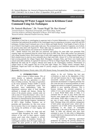
  • 4. Dr. Santosh Bhailume. Int. Journal of Engineering Research and Application www.ijera.com ISSN: 2248-9622, Vol. 6, Issue 9, (Part -3) September 2016, pp.46-49 www.ijera.com 48|P a g e VIII. RESULT AND DISCUSSION Land degradation is a composite term; it has no single readily-identifiable feature, but instead describes how one or more of the land resources (soil, water, vegetation, rocks, air, climate, relief) has changed for the worse. Another definition describes it as,” The aggregate diminution of the productive potential of the land, including its major uses (rain-fed, arable, irrigated, rangeland, forest), its farming systems (e.g. smallholder Subsistence) and its value as an economic resource." Land degradation due to waterlogging and salinization in sugarcane track of western Maharashtra is a serious problem. Here an attempt has been made to understand the problem of the salt affected and waterlogged areas by preparing an inventory using GIS techniques. The results of analysis are discussed in the following sections. The ECe and pH surfaces are classified according to critical limits given in methodology section and risk zonation maps for above- mentioned four depths are prepared (Figures 5.7 and 5.8). In segment IV, the pH ranges from 7 to 9 at various depths which indicates slight alkalinity. ECe varies from 0 to 5 ds/m which is far below the critical limit. The figures 5.7 and 5.8 indicate that almost entire area falls in a no risk to slight risk zone category. Overall there is not much variation observed in the values of pH and ECe, one reason might be the ill-distribution of the sample points. 8.1 Waterlogged Area Interpolating water depth values for 231 wells in the Segment IV (Fig. No. 2), watertable surface (Fig. No. 3) was generated and classified according to critical limits mentioned in methodology section. Risk zonation map of watertable (Fig. No. 3) indicates that the two villages namely Nagral and Burli situated close to canal are most vulnerable due to high water table. The Coming to next category, almost 2200 hectares (36 % of the total study area) of land covering partially the villages Nagral, Burli, Shirasgaon, Amnapur, Palus, and Yelavi fall under critical water table condition. Almost 60% of the land partially from all villages falls under the less critical category where the problem of water logging is not that much severe compare to earlier two categories. The 264 hectares of land(5% of the total land) from villages Nagral, Burli, Amnapur, Palus and Bhilawadi having water table above 3 meters is considered non critical to waterlogging condition. 74°22'48"E 74°22'48"E 74°24'54"E 74°24'54"E 74°27'0"E 74°27'0"E 74°29'6"E 74°29'6"E 74°31'12"E 74°31'12"E 16°59'42"N 16°59'42"N 17°1'48"N 17°1'48"N 17°3'54"N 17°3'54"N ± Krishna river Krishna canal 0 3 61.5 Kilometers Watertable sites ( wells & burma pits) Segment IV Legend Segment boundary Well locations (N 220) Fig. No. 2 Fig. No. 3 Table 3. Village wise statistics of waterlogged area Area in(ha) Sr. No. Village Name Most Critical Critical Less Critical Non Critical Total 1 Nagral 7 311 339 2 660. 2 Burli 1 567 610 1 1180 3 Dudhondi 22 22 4 Shirasgaon 202 6 269 5 Amnapur 932 450 . 1383 6 Palus 47 219 151 417 7 Yelavi 68 878 946 8 Bhilawadi 862 108 971 Total 8 2129 3450 264 5852
  • 5. Dr. Santosh Bhailume. Int. Journal of Engineering Research and Application www.ijera.com ISSN: 2248-9622, Vol. 6, Issue 9, (Part -3) September 2016, pp.46-49 www.ijera.com 49|P a g e Krishna canal Krishna river 0 3 61.5 Kilometers ± Legend Natural Nala Artificial drain Most Critical Critical Less Critical Non Critical Watertable Nagral Shirasgaon Dudhondi Burli Amnapur Palus Yelavi Bhilawadi Segment IV Risk zonation map of waterlogged areas 74°22'34"E 74°22'34"E 74°24'43"E 74°24'43"E 74°26'53"E 74°26'53"E 74°29'2"E 74°29'2"E 74°31'12"E 74°31'12"E 16°59'31"N 16°59'31"N 17°1'41"N 17°1'41"N 17°3'50"N 17°3'50"N Fig. No. 4 IX. CONCLUSION Salient features of the study are as below:  Risk zonation map of watertable suggests that the two villages namely Nagral and Burli situated close to canal are most vulnerable due to high water table. Almost 2200 hectares (36 % of the total study area) of land covering partially the villages Nagral, Burli, Shirasgaon, Amnapur, Palus, and Yelavi were found under critical water table condition.  In segment IV total covering an area of 792 ha in villages Nagral, Burli, Amnapur, Yelavi, and Bhilawadi fall under the P1 category affected most badly by the waterlogging condition. Out of the total area in segment IV, 1539 ha is found to be falling under P4 priority which do not poses severe problem as of now and can be considered later for reclamation.  In the segment IV, water table near canal is more than 2.5 m and towards Krishna river side it is swallowing to less than 1.5 m. This indicates that problem of improper drainage is more serious than that of seepage from canal.