Mount Etna located on the east coast of Sicily is classified as a stratovolcano and is the tallest active volcano in Europe at 3,329 m (10,922 ft). It remains one of the most active and dangerous volcanoes in the world. A major eruption of Etna and other volcanoes close to large cities such as Messina and Catania would be devastating to people, property, infrastructure, the environment, and the global economy.
BARREN ISLAND ACTIVE VOLCANO EFFECT INDIA-MYANMAR-THAILANDMYO AUNG Myanmar
Barren Island (Andaman Islands)
Barren Island erupting in 1995
Elevation 354 m (1,161 ft)
Location-Andaman Islands, India
Coordinates 12°16′40″N 93°51′30″ECoordinates: 12°16′40″N 93°51′30″E
Geology
Type Stratovolcano with pyroclastic cones
Last eruption 2013 to 2015 (ongoing)
Barren Island is located in the Andaman Sea, one of the most easterly of the Andaman Islands. It is the only confirmed active volcano in South Asia. Along with the rest of the Andamans, it is a part of the Indian Union Territory of Andaman and Nicobar Islands, and lies about 135 km (84 mi) northeast of the territory's capital, Port Blair. The first recorded eruption of the volcano dates back to 1787. Since then, the volcano has erupted more than ten times, with the most recent one which started in September 2010 and continued through January 2011.
After the first recorded eruption in 1787, further eruptions were recorded in 1789, 1795, 1803–04, and 1852. After nearly one and half century of dormancy, the island had another eruption in 1991 that lasted six months and caused considerable damage. There were eruptions in 1994–95 and 2005–07, the latter being considered to be linked to the 2004 Indian Ocean earthquake.This volcanic island stands in the midst of a volcanic belt on the edge of the Indian and Burmese tectonic plates. Narcondum is a dormant volcano in the area, apart from volcanic seamounts like Alcock and Sewell.
Tetsuya Hanamura
Environmental Management on Mt. Fuji and Mountains in Japan.
Declared a World Cultural Heritage site in 2013, Japan's Mt Fuji is a sacred place for worship and a source of artistic inspiration worldwide. In 2013, some 300,000 people climbed Mt. Fuji during the two months of July and August. The scale of such impact is a huge challenge. Dr. Hanamura described mountain management for this large numbers of visitors, including trash minimization and mountain toilet problems. He also described environmental practices in other Japanese mountains, including garbage clean up, human waste management, and the protection of alpine flowers and animals.
Dr. Hanamura is Vice President, International Relations, and Editor of the monthly magazine of the Japan Workers Alpine Federation (JWAF) which has 20,000 members. He is also a Member of the Coordination Committee for Mountain Conservation, consisting of seven mountain associations in Japan, and was a member of the drafting committee of the JWAF Declaration on the Preservation of Nature that came into effect in 2006. He received his MS Civil Engineering from UC Berkeley and his doctorate from Kyoto University and was Professor of Civil Engineering at Okayama (National) University from 2000-2009.
This is a web portal we use to communicate with our clients, and deliver our risk consulting material, such as: newsletters, flyers, payroll stuffers, posters, powerpoint presentations, instructor notes, quizzes, and on and on...
Some of our global opportunities to prevent “checkmates” during 2013 and beyond. Presentation courtesy of Dr. Walter Hays, Global Alliance for Disaster Reduction
A quick run down of the differences between saving and investing and what products have more risk and therefore, more rate of return. Also briefly covers how you should choose a financial professional.
March 15, 2015: The second world conference on disaster risk reduction convened in Sendai, Japan will re-invigorate the historic global endeavor started in 1990 by the United Nations. Presentation courtesy of Dr Walter Hays, Global Alliance for Disaster Reduction
A disaster is
--- the set of failures that overwhelm the capability of a community to respond without external help when three continuums: 1) people, 2) community (i.e., a set of habitats, livelihoods, and social constructs), and 3) complex events (e.g., earthquakes, landslides,..) intersect at a point in space and time.
Presentation courtesy of Dr. Walter Hays, Global Alliance for Disaster Reduction
ALL NATURAL HAZARDS. Capacity for intelligent emergency response, recovery and reconstructionis is essential for community resilience. Presentation courtesy of Dr Walter Hays, Global Alliance for Disaster Reduction
The 2016 Ecuador earthquake occurred on April 16 at 18:58:37 ECT with a moment magnitude of 7.8 and a maximum Mercalli intensity of VIII (Severe). The very large thrust earthquake was centered approximately 27 km (17 mi) from the towns of Muisne and Pedernales in a sparsely populated part of the country, and 170 km (110 mi) from the capital Quito, where it was felt strongly. Regions of Manta, Pedernales and Portoviejo accounted for over 75 percent of total casualties.[6] Manta's central commercial shopping district Tarqui, was completely destroyed. Widespread damage was caused across Manabi province, with structures hundreds of kilometres from the epicenter collapsing. At least 659 people were killed and 27,732 people injured. President Rafael Correa declared a state of emergency; 13,500 military personnel and police officers were dispatched for recovery operations.
LESSONS LEARNED FROM PAST NOTABLE DISASTERS: LANDSLIDES. Large volume landslides occur in association with an earthquake’s ground shaking or a typhoon’s rainfall. Presentation courtesy of Dr. Walter Hays, Global Alliance for Disaster Reduction
Indonesia’s most notable tsunami disaster tsunamis can accompany large subduction zone earthquakes generated as a result of complex interaction of the indo-australia and eurasiatectonic plates. In 2004, the existing indian ocean warning system was inadequate; so evacuation did not happen. Tsunami waves with wave heights of 4 to 10 m and inland runup of 3.3 km or more reached the coasts of all indian ocean nations- - - whose people were unevacuated and unprepared.As many as 220,000 people killed (120,000 in indonesia) --- and 500,000 injured. Presentation courtesy of Dr Walter Hays, Global Alliance for Disaster Reduction
Indonesia Earthquakes and Tsunamis
The mountain is a popular climbing destination, and at least 250 people were initially trapped on the slopes.
At least 30 were killed; most made their way down by Saturday night, but the injured, unable to descend the 10,062-foot mountain on their own, stayed in mountain lodges. The keys to resilience from volcanic disasters: 1) know the eruptive history of your region’s volcanoes, 2) be prepared 3) have a warning system 4) evacuate 5) learn from the experience and start over
There are five keys to resilience to volcanic corruption disasters: 1) know the eruptive history of your region’s volcanoes, 2) be prepared 3) have a warning system 4) evacuate 5) learn from the experience and be ready to start over
VOLCANIC ERUPTIONS are awesome manifestations of heat flowing as a result of mantle hot spots (e.g., Hawaii and Iceland) or explosive eruptions in subduction zones (e.g., the Pacific Rim). LESSON: THE KNOWLEDGE AND TIMING OF ANTICIPATORY ACTIONS IS VITAL. The people who know: 1) what hazards to expect (e.g., vertical ash plume, lateral blast, lava flow, lahar), 2) where and when they will happen, and 3) what they should (and should not) do to prepare for them will survive. The people who have timely, realistic, advance information that facilitates reduction of vulnerabilities, and hence the risks associated with the vertical ash plume, pyroclastic flows, tephra, lava flows, and lahars will survive. The people who have timely, accurate, advance information that facilitates evacuation to get our of harm’s way of pyroclastic flows, lava flows, and lahars will survive. The International Community provides millions to billions of dollars in relief to help “pick up the pieces, ” but this strategy is not enough by itself to ensure earthquake disaster resilience. THE CHALLENGE: CREATE, ADJUST, AND REALIGN PROGRAMS, PARTNERS AND PEOPLE UNTIL YOU HAVE CREATED THE KINDS OF TURNING POINTS NEEDED FOR MOVING TOWARDS VOLCANO DISASTER RESILIENCE. Presentation courtesy of Dr. Walter Hays, Global Alliance For Disaster Reduction
THE CHALLENGE: How do you make people, buildings, and infrastructure disaster resilient in communities that are known to be at high risk from floods, severe windstorms, earthquakes, landslides, tsunamis, volcanic eruptions, and wildfires? Presentation courtesy of Dr. Walter Hays, Global Alliance for Disaster Reduction
RUSSIA HAS MANY RIVERS THAT HAVE EXPERIENCED FLOODING Russia, the largest country in the world, and the only one surrounded by twelve seas and spread out on two continents, has many communities that are at risk from riverine flooding, flash floods, and floods from windstorms. Russia’s rivers in Europe include: the Volga, the Don, the Kama, the Oka, and the Northern Dvina. In Asia, Russia’s rivers include: the Ob, the Irtysh, the Yenisev, the Angara, the Lena, the Amur, the Yana, the Indiqirka, and the Kolyma.
PowerPoint presentation courtesy of Dr. Walter Hays, Global Alliance for Disaster Reduction
Making (or not making) our world disaster resilient will be our lasting legacy. History Will Decide Which Legacy We Actually Leave. Presentation courtesy of Dr. Walter Hays, Global Alliance for Disaster Reduction
Preparedness is a state of readiness on individual, urban, sub-regional, and national scales that is sufficient to keep the expected and unexpected effects of an earthquake from causing a disaster. Emergency Response consists of all the scripted and unscripted heroic and historic responses during the “race against time” after a quake to save lives and protect property. Key elements of preparedness: 1) know your tectonic plates and seismicity; 2) know your fault zones; 3) know your potential disaster agents; 4) know your vulnerabilities. State-of-the-art preparedness planning integrates all four factors. Prepareadness and emergency response increase as the capability to anticipate what will happen increases. Key elements of emergency response. HISTORIC RESPONSES: The professional and non-professional responders will be making history for at least forty-eight hours (a “place holder” for the intense period of search and rescue operations) and thirty days (a “place holder” for the intense time of the “no room for error” decisions) that must be made. Every time an earthquake disaster occurs, we have new knowledge to add to our “books of knowledge” on preparedness and emergency response. Presentation courtesy of Dr. Walter Hays, Global Alliance for Disaster Reduction
Making (or not making) our world disaster resilient is our legacy. History will decide which legacy we actually leave. The keys to resilience: 1) know the disaster history of your region, 2) be well-prepared 3) have a warning system 4) have an evacuation plan 5) learn from every global experience and start over. Presentation courtesy of Dr. Walter Hays, Global Alliance For Disaster Reduction.
Similar to MOUNT ETNA ERUPTS AGAIN 19 February 2013 (20)
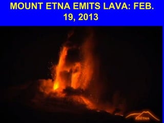
Particulate matter is a mixture of very small solids and liquid droplets that float in the air. Some particles come from a specific source (such as a burning candle), while others form as a result of complicated chemical reactions. While much is known about the health effects of exposure to particulate matter outdoors, the effects of indoor exposure are less well-understood. However, indoor exposure to particulate matter is gaining attention as a potential source of adverse health effects.
Two drivers stand out in this analysis because of their potentially large and negative effect on disaster risk, and the low associated uncer tainty of their future trends: global environmental change and demographic change. But others stand out for a different reason: while they have the potential to greatly increase disaster risk, there is also potential for effective policy action to achieve risk reduction. Urbanisation provides the clearest example: unmanaged growth of cities, par ticularly those in low elevation coastal zones, would leave millions in extremely vulnerable situations, but there will be oppor tunities for policy makers to intervene to increase resilience in urban areas. Other drivers, for example globalisation, have extremely complex interactions with disaster risk, but must nonetheless be considered. In this lecture I will discuss the impact of each of the eight drivers on disaster risk is considered.
The objective of this study is to evaluate the seismic hazard at the northwestern Egypt using the probabilistic seismic hazard assessment approach. The Probabilistic approach was carried out based on a recent data set to take into account the historic seismicity and updated instrumental seismicity. A homogenous earthquake catalogue was compiled and a proposed seismic sources model was presented. The doubly-truncated exponential model was adopted for calculations of the recurrence parameters. Ground-motion prediction equations that recently recommended by experts and developed based upon..
A powerful 7.5 magnitude earthquake rocked parts of South Asia on 26 October 2015. It was centred near Jurm in northeast Afghanistan, 250 kilometres (160 miles) from the capital Kabul and at a depth of 213.5 kilometres, the US Geological Survey said. (AFP, 26 Oct 2015) Pakistan's confirmed death toll so far stands at 272, with more than 1,900 people injured and nearly 14,000 homes damaged, though the spokesman said the NDMA was still in the process of estimating a final toll. (AFP, 28 Oct 2015) In Afghanistan, Assessment reports indicate 117 deaths, 544 people injured, 12,794 homes damaged and 7,384 houses destroyed. Furthermore, 136,967 people are still in need of humanitarian assistance, of which 131,345 people have received some form of assistance so far date. More than 51,000 people were affected in Badakhshan alone, where property damage was most extensive. The earthquake claimed the most lives and caused the most casualties in Kunar and Nangarhar provinces. Access remains the most significant challenge in providing assistance to people in need and is an issue reaching at least 194 villages affected by the earthquake.
A torrential rain event during the first full week of March 2016 featuring over two feet of record March rain in the South unleashed major river flooding, rising to historic levels in some areas. Add flooding along the Gulf Coast, and the disaster became a triple assault. In all, 400 homes flooded in Mississippi. Three people were killed in Louisiana, the governor said. In one case, a driver died when floodwater swept his vehicle off a road in Bienville Parish, the Governor's Office of Homeland Security and Emergency Preparedness said. The two others died in Ouachita Parish, according to the Louisiana Department of Health and Hospitals.
The moderate-magnitude quake struck at 9:26 p.M. Thursday night at a depth of 11 kilometers (7 miles) in southern Japan near Kumamoto city on the island of Kyushu. The epicenter was 120 kilometers (74 miles) northeast of Kyushu Electric Power Company's Sendai nuclear plant, the only one operating in the country; no adverse consequences were reported.
Lesson: the knowledge and timing of anticipatory actions is vital
The Kathmandu Valley is densely populated with nearly 2.5 million people, and the quality of building construction is often poor. The epicenter of today's disaster was 80 kilometers (50 miles) northwest of the city, and had a depth of only 11 kilometers (7 miles), which is considered shallow in geological terms. This earthquake, the worst quake to hit Nepal (a poor South Asian nation) since 1934, collapsed buildings and houses, leveled centuries-old temples and triggered avalanches in the Himalayas. Presentation courtesy of Dr Walter Hays, Global Alliance for Disaster Reduction.
The Third UN World Conference on Disaster Risk Reduction was held from 14 to 18 March 2015 in Sendai City, Miyagi Prefecture, Japan. Several thousand participants attended, including at related events linked to the World Conference under the umbrella of building the resilience of nations and communities to disasters. The United Nations General Assembly Resolution for 2013 on International Strategy for Disaster Reduction states that the World Conference will result in a concise, focused, forward-looking, and action-oriented outcome document and will have the following objectives:
* To complete assessment and review of the implementation of the Hyogo Framework for Action;
* To consider the experience gained through the regional and national strategies/institutions and plans for disaster risk reduction and their recommendations as well as relevant regional agreements within the implementation of the Hyogo Framework of Action;
* To adopt a post-2015 framework for disaster risk reduction;
* To identify modalities of cooperation based on commitments to implement a post-2015 framework for disaster risk reduction;
* To determine modalities to periodically review the implementation of a post-2015 framework for disaster risk reduction.
Presentation courtesy of Dr Walter Hays, Global Alliance for Disaster Reduction
Popocatapatele and Colima, two of Mexico’s most active volcanoes, are acting up again. For now the eruptions are not considered to be dangerous and no evacuations have been ordered. But don’t forget that the world’s 1,498 other active volcanoes can erupt at anytime too. A re-eruption of any of these active volcanoes is likely to be very devastating, locally, regionally, and globally. Location and a large explosivity index (VEI) combine to make some volcanoes especially dangerous. Location refers to proximity to cities and other areas of high human population density. An eruption with large VEI at such locations is certain to be devastating to people, their property, their health, the community infra-structure, the environment, and the economy. Presentation courtesy of Dr Walter Hays, Global Alliance for Disaster Reduction.
INDIA IS BIG, DIVERSE, and CAPABLE. It is the seventh largest country, The second most populous country with human resources of over 1.2 billion people having cultural and religious diversity, The most populous democracy, with many well- educated and well-trained people, with high-tech and low-tech capabilities. On the downside, it is also a country with many living in poverty, with many living in non-earthquake-resistant housing, with cities and towns that are dependent upon non- earthquake-resistant infrastructure and critical facilities. India faces potential disasters each year from floods, earthquakes, and cyclones, some of which have triggered notable disasters in the past, and very recently. That will happen again, unless a paradigm shift occurs. Disaster resilience has become an urgent global goal in the 21st century as many Nations are experiencing disasters after a natural hazard strikes, and learning that their communities, institutions, and people do NOT yet have the capacity to be disaster resilient. Disaster resilience does not just happen; it is the result of decision-making for a national paradigm shift from the status quo to an improved “coping capacity” that enables the country to rebound quickly after a disaster. A paradigm shift towards earthquake disaster resilience is a three step process. Step 1: Integrate Past Experiences Into Books of Knowledge. Step 2: From Books of Knowledge to Innovative Educational Surges to Build Professional and Technical Capacit. Step 3: From Professional and Technical Capacity to Disaster Resilience. In summary, BOOKS OF KNOWLEDGE are are “TOOLS” to facilitate India’s continuing commitment to minimize the likely impacts of the inevitable future earthquake, thereby preventing another disaster
Disaster resilience, which is the capacity of a country to rebound quickly after the socioeconomic impacts of a disaster, requires decision-making for a national paradigm shift from the status quo. Disaster resilience has become an urgent global goal in the 21st century as many Nations are experiencing disasters after a natural hazard strikes, and learning that their communities, institutions, and people do NOT yet have the capacity to be disaster resilient. Presentation courtesy of Dr Walter Hays, Global Alliance for Disaster Reduction.
On January 29, 2015, a routine delivery of gas to a maternity hospital in Mexico City leads to a deadly explosion killing 4 and injuring dozens. The explosion occurred when a gas tanker was making a routine, early morning delivery of gas to the hospital kitchen, and gas started to leak. The tanker workers worked for 15 to 20 minutes to repair the leak while a large cloud of gas was forming, then exploded. Technologies for monitoring, forecasting, and warning are vital for becoming resilient. Presentation courtesy of Dr Walter Hays, Global Alliance for Disaster Reduction
Disasters are caused by single- or multiple-event natural hazards that, (for various reasons), cause extreme levels of mortality, morbidity, homelessness, joblessness, economic losses, or environmental impacts. The keys to resilience: 1) know the history of past disasters 2) be prepared 3) have a warning system 4) evacuate 5) learn from the experience
As we begin the year 2015, we must unfortunately recognize that it is well past the time to speed up the long-term recovery process for earthquakes (and tsunamis). The main insights from global earthquakes have consistently shown that being prepared includes pre-earthquake planning for post-earthquake recovery ("PEPPER"). Only about 110 of the 10 million earthquakes of all sizes that occur somewhere in the world each year are large enough and close enough to a community to cause a disaster, which creates a multitude of local and regional dilemmas about what to do, both before and after the quake, to shorten the recovery process. THE SOLUTION: PRE-EARTHQUAKE PLANNING FOR POST-EARTHQUAKE RECOVERY(PEPPER). “THE END GAME” FOR JAPAN AND SOUTHERN CALIFORNIA: Identification of the physical, social and economic consequences of a major earthquake in Tokai, Japan or Southern California will enable end users to identify what they can change now before the earthquake—to shorten recovery from the catastrophic impacts after the inevitable “big ones” occur, probably in the near future.
Floods occur somewhere in the world 10,000 times or more each year. With 2015’s spring floods only weeks away, it’s past time to speed up the long-term recovery process for floods. In 2008, after weeks of flooding through Iowa, Illinois, Missouri, Indiana and Wisconsin, the region faced billions of dollars in losses, threats of disease, and a long cleanup. Losses included millions of acres of prime farm land that are still requiring restoration and the rebuilding of large urban areas such as Cedar Rapids, Iowa which alone is estimated to have required at least $1 billion. However, the total direct and indirect losses may never be known. Flood waters during the summer of 2008 seeped into countless wells, affecting drinking water for thousands of homes and businesses across the region. Hazardous materials were also released into the flood waters that ultimately emptied into the Gulf of Mexico exacerbating what marine biologists call a “dead zone” – bodies of water so starved for oxygen that aquatic life can no longer be supported. Presentation courtesy of Dr Walter Hays, Global Alliance for Disaster Reduction.
A focus on actions in 2015 will accelerate the transition from the past 14 years of global disaster proneness to global disaster resilience by 2020. A snaphot of our world circa 1st January 2015: 7+ billion people, and growing while Living and competing in an interconnected global economy, producing $60 trillion+ of products each year,and facing complex disasters every year that cause multi-billions in losses and reduce a community’s ability to withstand natural catastrophes. The challenge of our time in the 21st century: Protecting and preserving PEOPLE and COMMUNITIES from the potential disaster agents of natural hazards. The “best solution set” vis a vis the global policy framework to strengthen disaster resilience include (1) anticipate and plan for the full spectrum of what can happen; (2) to build capacity at the community level to strengthen disaster in the areas of preparedness, protection, early warning, emergency response, and recovery/reconstruction; (3) to be relentless in informing, educating, training, and building equity in all areas that constitute disaster resilience in all sectors of every community in every nation. WE KNOW WHAT TO DO AND HOW TO DO IT. But just knowing is not enough. Tangible action is essential to reach the urgent goal of global disaster resilience by 2020 and will require that all communities work strategically to implement a realistic set of scientific, technical, and political solutions nested within EXISTING administrative, legal, and economic constraints. Presentation courtesy of Dr Walter Hays, Global Alliance for Disaster Reduction.
A disaster is the set of failures that occur when three continuums: 1) people, 2) community (i.e., a set of habitats, livelihoods, and social constructs), and 3) recurring events (e.g., floods, earthquakes, ...,) intersect at a point in space and time, when and where the people and community are not ready. We have an opportunity after each record or near-record disaster of the 21st century to accelerate the recovery and reconstruction process, one of the five pillars of global disaster resilience. Strategy: take advantage of recovery/reconstruction. The political and media spotlight is on all decisions and activities. Political priority: restoration to normal (or better) as quickly as possible. International assistance, insurance payouts, and donors: always available. What is the payoff of global disaster resilience? Failure: we will have disasters during the 21st century that could make 1990—2014’s disasters look like “a walk in the park.” Success: everyone wins. A disaster is the set of failures that occur when three continuums: 1) people, 2) community (i.e., a set of habitats, livelihoods, and social constructs), and 3) recurring events (e.g., floods, earthquakes, ...,) intersect at a point in space and time, when and where the people and community are not ready. We have an opportunity after each record or near-record disaster of the 21st century to accelerate the recovery and reconstruction process, one of the five pillars of global disaster resilience. Strategy: take advantage of recovery/reconstruction. The political and media spotlight is on all decisions and activities. Political priority: restoration to normal (or better) as quickly as possible. International assistance, insurance payouts, and donors: always available. What is the payoff of global disaster resilience? Failure: we will have disasters during the 21st century that could make 1990—2014’s disasters look like “a walk in the park.” Success: everyone wins. Presentation courtesy of Dr Walter Hays, Global Alliance for Disaster Reduction
More from Professor Eric K. Noji, M.D., MPH, DTMH(Lon), FRCP(UK)hon (20)
Unit 8 - Information and Communication Technology (Paper I).pdfThiyagu K
This slides describes the basic concepts of ICT, basics of Email, Emerging Technology and Digital Initiatives in Education. This presentations aligns with the UGC Paper I syllabus.
Read| The latest issue of The Challenger is here! We are thrilled to announce that our school paper has qualified for the NATIONAL SCHOOLS PRESS CONFERENCE (NSPC) 2024. Thank you for your unwavering support and trust. Dive into the stories that made us stand out!
2024.06.01 Introducing a competency framework for languag learning materials ...Sandy Millin
http://sandymillin.wordpress.com/iateflwebinar2024
Published classroom materials form the basis of syllabuses, drive teacher professional development, and have a potentially huge influence on learners, teachers and education systems. All teachers also create their own materials, whether a few sentences on a blackboard, a highly-structured fully-realised online course, or anything in between. Despite this, the knowledge and skills needed to create effective language learning materials are rarely part of teacher training, and are mostly learnt by trial and error.
Knowledge and skills frameworks, generally called competency frameworks, for ELT teachers, trainers and managers have existed for a few years now. However, until I created one for my MA dissertation, there wasn’t one drawing together what we need to know and do to be able to effectively produce language learning materials.
This webinar will introduce you to my framework, highlighting the key competencies I identified from my research. It will also show how anybody involved in language teaching (any language, not just English!), teacher training, managing schools or developing language learning materials can benefit from using the framework.
Ethnobotany and Ethnopharmacology:
Ethnobotany in herbal drug evaluation,
Impact of Ethnobotany in traditional medicine,
New development in herbals,
Bio-prospecting tools for drug discovery,
Role of Ethnopharmacology in drug evaluation,
Reverse Pharmacology.
Synthetic Fiber Construction in lab .pptxPavel ( NSTU)
Synthetic fiber production is a fascinating and complex field that blends chemistry, engineering, and environmental science. By understanding these aspects, students can gain a comprehensive view of synthetic fiber production, its impact on society and the environment, and the potential for future innovations. Synthetic fibers play a crucial role in modern society, impacting various aspects of daily life, industry, and the environment. ynthetic fibers are integral to modern life, offering a range of benefits from cost-effectiveness and versatility to innovative applications and performance characteristics. While they pose environmental challenges, ongoing research and development aim to create more sustainable and eco-friendly alternatives. Understanding the importance of synthetic fibers helps in appreciating their role in the economy, industry, and daily life, while also emphasizing the need for sustainable practices and innovation.
How to Make a Field invisible in Odoo 17Celine George
It is possible to hide or invisible some fields in odoo. Commonly using “invisible” attribute in the field definition to invisible the fields. This slide will show how to make a field invisible in odoo 17.
This is a presentation by Dada Robert in a Your Skill Boost masterclass organised by the Excellence Foundation for South Sudan (EFSS) on Saturday, the 25th and Sunday, the 26th of May 2024.
He discussed the concept of quality improvement, emphasizing its applicability to various aspects of life, including personal, project, and program improvements. He defined quality as doing the right thing at the right time in the right way to achieve the best possible results and discussed the concept of the "gap" between what we know and what we do, and how this gap represents the areas we need to improve. He explained the scientific approach to quality improvement, which involves systematic performance analysis, testing and learning, and implementing change ideas. He also highlighted the importance of client focus and a team approach to quality improvement.
The Roman Empire A Historical Colossus.pdfkaushalkr1407
The Roman Empire, a vast and enduring power, stands as one of history's most remarkable civilizations, leaving an indelible imprint on the world. It emerged from the Roman Republic, transitioning into an imperial powerhouse under the leadership of Augustus Caesar in 27 BCE. This transformation marked the beginning of an era defined by unprecedented territorial expansion, architectural marvels, and profound cultural influence.
The empire's roots lie in the city of Rome, founded, according to legend, by Romulus in 753 BCE. Over centuries, Rome evolved from a small settlement to a formidable republic, characterized by a complex political system with elected officials and checks on power. However, internal strife, class conflicts, and military ambitions paved the way for the end of the Republic. Julius Caesar’s dictatorship and subsequent assassination in 44 BCE created a power vacuum, leading to a civil war. Octavian, later Augustus, emerged victorious, heralding the Roman Empire’s birth.
Under Augustus, the empire experienced the Pax Romana, a 200-year period of relative peace and stability. Augustus reformed the military, established efficient administrative systems, and initiated grand construction projects. The empire's borders expanded, encompassing territories from Britain to Egypt and from Spain to the Euphrates. Roman legions, renowned for their discipline and engineering prowess, secured and maintained these vast territories, building roads, fortifications, and cities that facilitated control and integration.
The Roman Empire’s society was hierarchical, with a rigid class system. At the top were the patricians, wealthy elites who held significant political power. Below them were the plebeians, free citizens with limited political influence, and the vast numbers of slaves who formed the backbone of the economy. The family unit was central, governed by the paterfamilias, the male head who held absolute authority.
Culturally, the Romans were eclectic, absorbing and adapting elements from the civilizations they encountered, particularly the Greeks. Roman art, literature, and philosophy reflected this synthesis, creating a rich cultural tapestry. Latin, the Roman language, became the lingua franca of the Western world, influencing numerous modern languages.
Roman architecture and engineering achievements were monumental. They perfected the arch, vault, and dome, constructing enduring structures like the Colosseum, Pantheon, and aqueducts. These engineering marvels not only showcased Roman ingenuity but also served practical purposes, from public entertainment to water supply.
How to Create Map Views in the Odoo 17 ERPCeline George
The map views are useful for providing a geographical representation of data. They allow users to visualize and analyze the data in a more intuitive manner.
Instructions for Submissions thorugh G- Classroom.pptxJheel Barad
This presentation provides a briefing on how to upload submissions and documents in Google Classroom. It was prepared as part of an orientation for new Sainik School in-service teacher trainees. As a training officer, my goal is to ensure that you are comfortable and proficient with this essential tool for managing assignments and fostering student engagement.
The Indian economy is classified into different sectors to simplify the analysis and understanding of economic activities. For Class 10, it's essential to grasp the sectors of the Indian economy, understand their characteristics, and recognize their importance. This guide will provide detailed notes on the Sectors of the Indian Economy Class 10, using specific long-tail keywords to enhance comprehension.
For more information, visit-www.vavaclasses.com
3. Mount Etna emits lava flow
in the early hours of
February 19, 2013
4. MOUNT ETNA
Mount Etna is the result of convergence
between the African and Eurasian
Plates.
5. MOUNT ETNA
Mount Etna, an active stratovolcano on
the east coast of Sicily and the tallest
active volcano in Europe at 3,329 m
(10,922 ft), is close to Messina and
Catania.
6. Mount Etna, one of the most
active volcanoes in the world,
has been in an almost constant
state of activity for years.
8. ETNA: ONE OF WORLD’S
DANGEROUS VOLCANOES
A major eruption of Etna and other
volcanoes close to major population
centers would be devastating to
people, property, infrastructure, the
environment, and the global
economy.
14. INDONESIA’S MOUNT MERAPI
ERUPTS ON MAY 15, 2006
• Mount Merapi
emitted lava,
debris, and a
pyroclastic
flow or cloud
on May 15.
15. MOUNT SOMMA-VESUVIUS
• Location: Bay
Naples, east of
the city of
Naples, Italy
MDA Federal’s NaturalVue 2000. 6011 Executive Blvd, Suite 400,
Rockville, Md, 20852
http://en.wikipedia.org/wiki/Image:Naplesbay01.jpg
27. Krakatau
• Location: between Java and Sumatra
• Date: 26-27 August, 1883
• Time: 2610:02 am (GMT)-The big one!
http://www.geology.sdsu.edu/how_volcanoes_work/Krakatau.html
28. SHOULD WE BE THINKING ABOUT
ANOTHER KRAKATOA ERUPTION ?
!
Krakatoa: Pre-1883 Eruption Anak Krakatoa—Son of Krakatoa