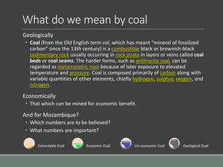
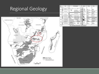
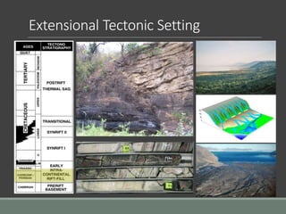
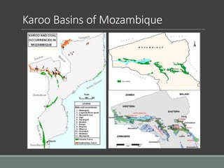
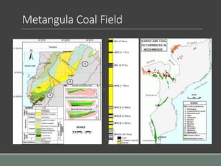
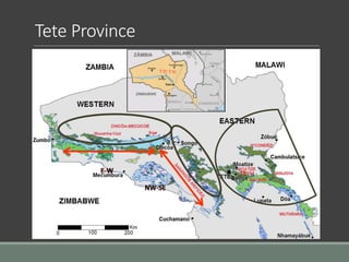
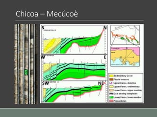
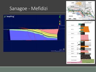
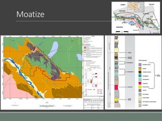
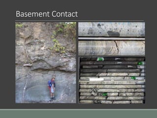
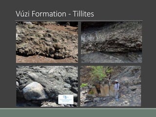
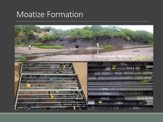
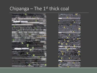
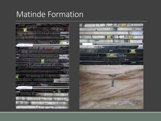
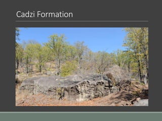
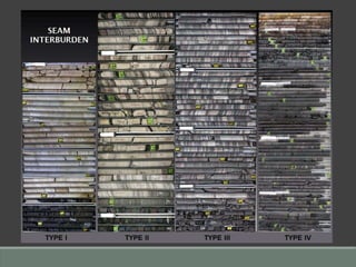
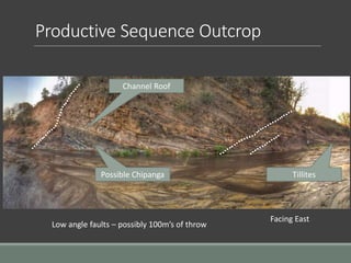
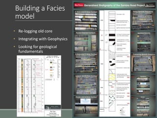
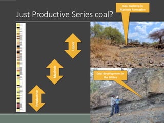
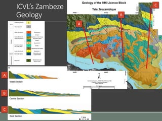
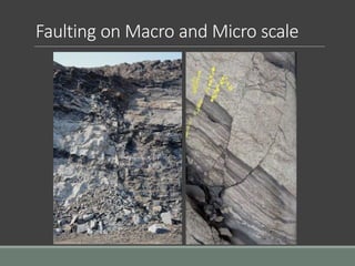
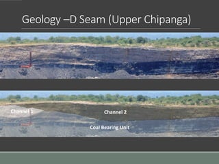
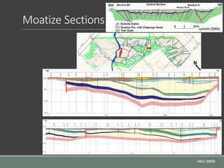
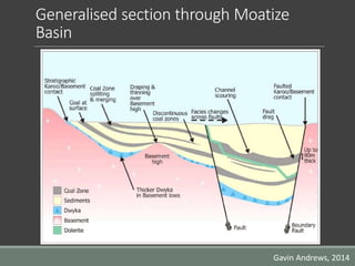
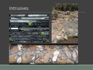
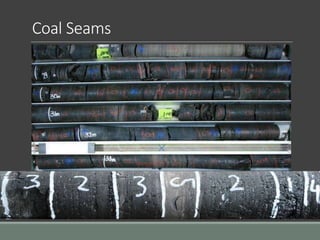
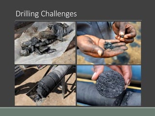
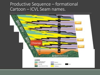
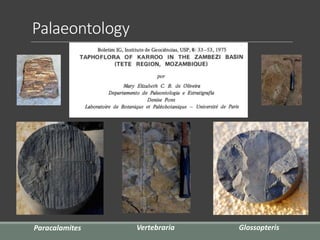
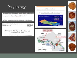
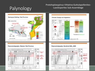
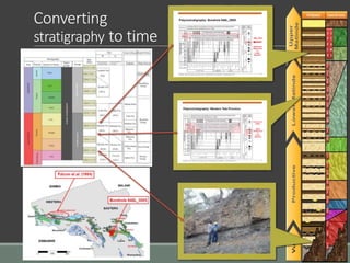
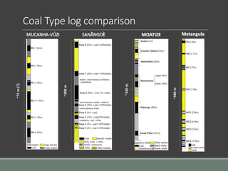
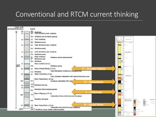
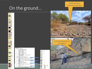
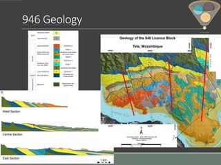
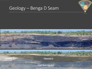
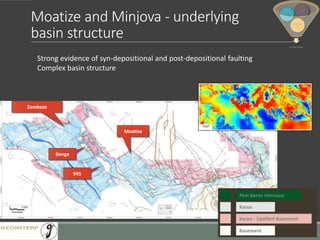
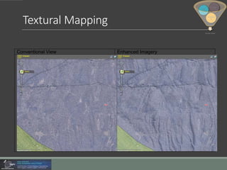
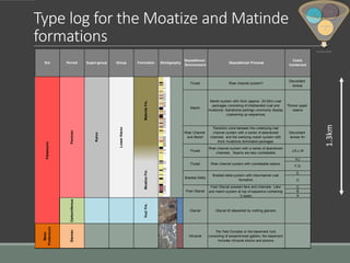
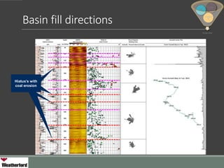
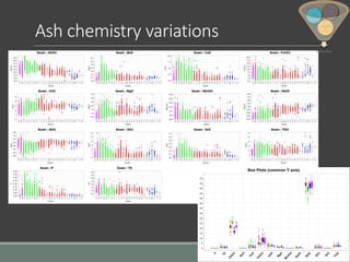
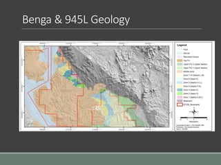
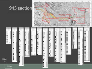
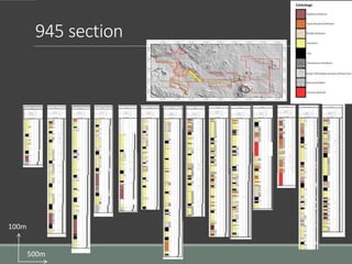
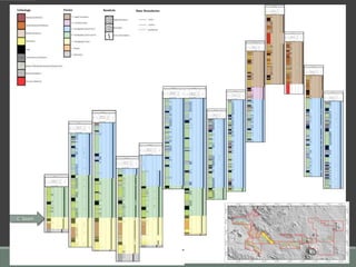
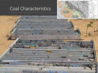
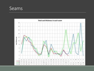
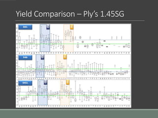
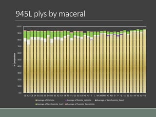
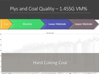
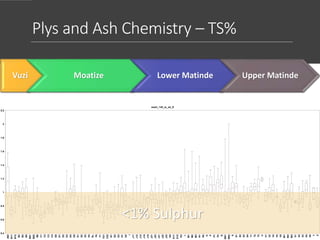
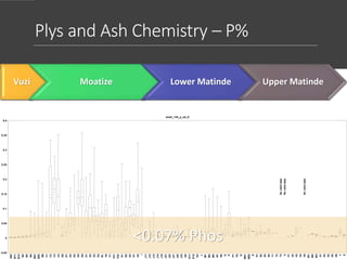
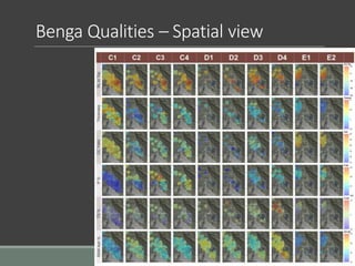
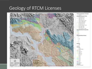
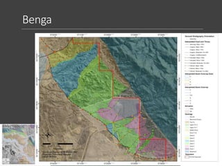
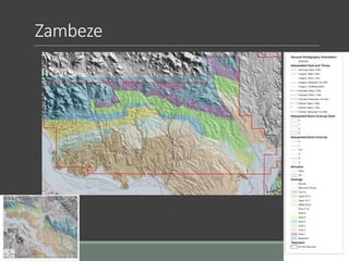
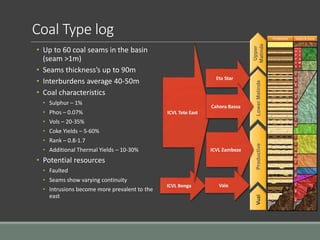
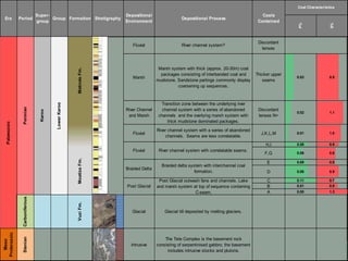
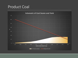
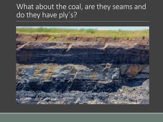
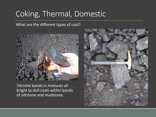
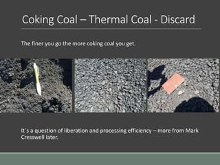
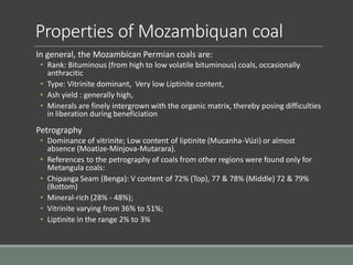
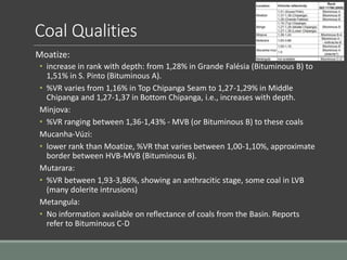
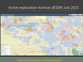
The document provides an overview of the coal deposits in Mozambique. It discusses the regional geology, including the Karoo basins and productive sequences. The Tete Province is a focus, with details on exploration learnings. The coal seams show varying thickness, quality, and continuity due to faulting and intrusions. While over 60 seams have been identified in the basins, the coals generally have low sulfur and phosphorus content, and yields of 5-60% coking coal and 10-30% thermal coal. The geology and coal characteristics indicate significant but complex coal resources in Mozambique.
1. Sampling of minerals involves collecting portions of rocks or ores to determine their quality and composition. There are different types and methods of sampling depending on whether it is done above or below ground.
2. Common sampling methods include grab sampling, channel sampling, chip sampling, and drill hole sampling. Grab sampling involves collecting rock specimens while channel sampling cuts channels across rock faces.
3. Sampling seeks to provide a representative sample of the whole deposit but can be subject to random and systematic errors from factors like improper spacing, insufficient samples, or incorrect analysis. Proper sampling techniques aim to minimize these errors.
This document summarizes sedimentary basins in India. It discusses how sedimentary basins form primarily through convergent, divergent, and transform tectonic boundaries. India has 26 sedimentary basins that have been divided into four categories based on their prospectivity for hydrocarbons. Category I basins have proven commercial production, while Category II have known hydrocarbon occurrences but no production. Category III are prospective based on geology, while Category IV require more data but show potential. The document concludes that sedimentary basins preserve important information and contain critical resources like hydrocarbons that are used for fuel and various industrial materials.
The document summarizes the structure and dynamics of the Earth. It describes how the Earth is composed of layers with different densities, including the crust, mantle, and core. It explains that the lithosphere is divided into tectonic plates that move over the asthenosphere due to convection currents in the mantle. There are three main types of plate boundaries - divergent where new crust forms, convergent where plates collide and one is subducted, and transform where plates slide past each other. Plate tectonics involves the creation of oceanic crust at mid-ocean ridges and recycling of crust through subduction.
Petroleum system and geology of lower indus basinhamza3195
this presentation is about the petroleum system and geology of lower indus basin. moreover there are some operational fields discussed in this presentation.
This document defines metasomatism and describes the classification of metasomatic rocks and processes. It begins by defining metasomatism as the pervasive alteration of a rock's chemical composition through interaction with aqueous fluids, while remaining in a solid state. It describes two main types of metasomatism - diffusional and infiltrational - based on the transport mechanism. The document then presents a systematic scheme for classifying metasomatic rocks and processes based on zones, facies, and families. It provides examples of different metasomatic families and describes their relationships to temperature, pressure, and fluid chemistry conditions.
The Aravalli Craton in western India is divided into eight elements based on geology and age. It contains ancient gneiss and supracrustal rocks from the Archean era, followed by sedimentary and volcanic sequences from the Paleoproterozoic and Mesoproterozoic. Notable features include large lead-zinc deposits, stromatolitic phosphorites, and the large felsic Malani Igneous Suite from the Neoproterozoic. The oldest rocks date to 3300 million years ago, and the craton has undergone multiple periods of tectonism, magmatism, and basin formation.
The document discusses ore formation systems and processes. It describes how ores were originally thought to form mainly from the cooling and crystallization of magmatic bodies. It then explains that four main ore formation processes are recognized: 1) orthomagmatic processes related to magma evolution and crystallization, 2) hydrothermal processes involving mineralization from magmatic fluids, 3) sedimentary processes concentrating metals through weathering, erosion and sedimentation, and 4) metamorphic processes transforming existing ore deposits. The document provides details on each of these processes and how they concentrate metals to form economic mineral deposits.
1. The document discusses the relationship between plate tectonics and metal deposits. It describes various tectonic settings associated with divergent and convergent plate boundaries that are favorable for forming different types of metal deposits.
2. Key settings discussed include continental rifts, failed rift arms, passive continental margins during seafloor spreading, mid-ocean ridges, and subduction zones. Metallogeny in these settings includes deposits forming from hydrothermal vents, volcanic-hosted massive sulfides, and porphyry copper deposits.
3. The formation of different deposit types is tied to the specific geological processes associated with different stages of plate interactions, such as crustal extension during rifting and compression during
The document summarizes the Jurassic stratigraphy of the Kutch region in India. It describes the key geological formations that date from the Middle Jurassic to Lower Cretaceous periods, including the Pachcham Formation consisting of limestones and corals, the Chari Formation containing sandy limestones and marls, the Katrol Formation made up of shales, limestones and sandstones, and the Umia Formation comprising sandstone, shale and conglomerate. It provides context that these sedimentary rocks formed during a phase of marine transgression in the western part of India during the Jurassic Period.
Alkaline magmatic rocks are igneous rocks that contain more alkalis (Na2O + K2O) than feldspars alone can accommodate. They commonly contain feldspathoids like nepheline, sodalite, or leucite. Examples include phonolites, nepheline syenites, and basanites. Alkaline rocks can be classified based on their silica and alumina content relative to alkalis. The most silica-undersaturated alkaline rocks are carbonatites. Debate occurred over whether carbonatites had an igneous or replacement origin, but experimental evidence and observations of carbonate lavas support a magmatic origin.
The document summarizes the chronological development of mining technology from the earliest uses of stone tools by Paleolithic humans 450,000 years ago to modern mechanized mining in the 20th century. Key developments include the first underground mine 40,000 years ago in Africa, the use of smelting and fabricated metals in the Bronze Age 4000 years ago, organized mining by the Egyptians and industrialized mining by the Romans, and advances during the Industrial Revolution including safety lamps and dynamite in the 19th century and mechanization in the 20th century.
Kutch is an East-west Oriented pericraton Rift basin Situated between Nagar Parkar Fault in North and Kathiawar Uplift in South.
Here we will discuss Geology and its Sequence Stratigraphy.
Sulfide mineralization are the main resource for exploiting Pb, Zn, and Cu metals in Egypt.
Sulfide mineralization is represented by four sulfide types of the different setting, lithology and ages, namely:
i) Lead-Zinc sulphide Deposits
ii) Cu-NiCo sulphide Deposits
This type of mineralization is well represented in Abu Swayel in South Eastern Desert. The ore is closely related to mafic-ultramafic and gabbro of ophiolitic rocks.
iii) Cu-Ni sulphide deposits
This type of mineralization occurs in layered mafic-ultramafic intrusions like gabbro rocks at Akarm and El Geneina .
iv) Stratiform Massive Sulphide (Zn-Cu-Pb) Deposits
This type of mineralization is represented by a group of small lenses associated with talc deposits in South Eastern Desert at: Um Samuki, Helgit, Maakal, Atshan, Darhib, Abu Gurdi, and Egat.
Mechanical concentration forms placer deposits by separating heavy minerals from light ones using gravity and moving fluids like water or air. Placer deposits can form in various environments including along hill slopes (eluvial placers), in streams (alluvial placers), on beaches, and from wind (eolian placers). Key factors that influence concentration include differences in mineral density, size, shape, and the velocity of the moving fluid. Common minerals found in placer deposits include gold, platinum, tin, magnetite, and chromite due to their high density and resistance to weathering.
This document provides information on the geology of the Pishin Basin in Pakistan. It describes 11 geological formations that are present in the basin, from oldest to youngest: the Muslim Bagh-Zhob Ophiolite from the Cretaceous period, the Nisai Formation from the Early Eocene to Early Oligocene, the Khojak Formation which includes the Murgha Faqirzai and Shaigalu members from the Oligocene, the Khuzhobai Formation of uncertain age, the Bahlol Nika Formation from the Middle to Late Miocene, the Sra Khula Formation also from the Middle to Late Miocene, the Malthanai Formation from the Late
Hi I'm Misson Choudhury , A Post Graduate student, Graduated from Utkal university and Now pursuing my m.sc in applied geology at Bangalore university, Bangalore, i love geological mapping,drawing,hill climbing and tracking..
This document provides information on igneous petrology and the classification of igneous rocks. It discusses different classification systems including genetic, textural, chemical, and mineralogical classifications. It also describes techniques for chemical analysis of rocks and key concepts in igneous petrology such as saturation, variation diagrams, and the use of major and trace elements to understand rock origins.
1. The document discusses ore textures and paragenetic sequences, beginning with definitions and requirements for studying ore textures.
2. It describes various ore textures including single grain textures, magmatic ore textures, open space filling textures, and replacement textures.
3. The document concludes with a discussion on developing paragenetic sequences by analyzing features like cross-cutting relationships and exsolution textures.
1) Carbonate group minerals contain carbon, oxygen, and one or more metallic elements. Calcite and dolomite are common examples.
2) They have a variety of structures but generally have a carbonate ion group (CO3) with a cation situated in the center.
3) Calcite, dolomite, and aragonite are the main carbonate mineral groups. Calcite is the most abundant and has many industrial uses like cement production. Dolomite is also commonly used in construction.
http://www.spiderresources.com - In this presentation by Spider Resources Board of Directors member Dr. James Franklin, P.Geo. explains the importance of Chromite in today's world
This document provides information on the optical and physical properties of various mineral samples. It describes several key properties of minerals including their crystal form, habit, cleavage, parting, inclusions, and twinning. It also discusses their optical properties without and with an analyzer, such as color, reflectivity, bireflectance, anisotropism, and internal reflection. Finally, it presents information on various ore textures like colloform, deformation, banded iron formation, flame, oolitic, and exsolution textures.
Methods and stages of Mineral Exploration: Adaptive Resource Management PlanNgatcha Bryan
Exploration can be divided into a number of interlinked and sequential stages which involve increasing
expenditure and decreasing risk. Early stages of exploration are planning and prospecting. The planning
stage covers the selection of commodity, type of deposit, exploration methods, and the seĴing up of an
exploration entity. Prospecting covers activities leading to the selection of an area for detailed ground
work; this is the point at which land is acquired. The subsequent stages involve targeted prospecting and
exploration in order to quantify and qualify the mineral resources. Pre-feasibility study is then
performed for evaluating the commercial viability of the deposit (Adapted from Moon et al., 2006).
The document summarizes the various processes of formation of ore deposits, which are grouped into three main types: magmatic, sedimentary, and metamorphic. Magmatic processes include magmatic concentration, hydrothermal processes, and sublimation. Sedimentary processes include sedimentary deposits, oxidation and supergene enrichment, residual and mechanical concentration, volcanogenic deposits, evaporation, and bacteriogenic processes. The key magmatic and sedimentary processes are described in further detail.
Geochemical methods in mineral explorationPramoda Raj
This document discusses geochemical methods for mineral exploration. It covers general principles of geochemistry as they relate to mineral deposits. It also discusses optimizing exploration through proper planning, selection of areas and methods, and organization of field, lab, and supervisory operations. Geochemistry is described as an essential component of modern integrated exploration programs due to the low-grade, large-tonnage nature of most economic deposits and its effectiveness in weathered tropical environments.
The document discusses lead and zinc deposits found in India. It describes the chief ores of lead (galena, cerussite, anglesite) and zinc (sphalerite, smithsonite). It then discusses several major lead-zinc deposits in India, including Rampura-Agucha and Zawar belts, characterized by stratabound sedimentary hosted deposits. Other deposits mentioned include Sargipalli and Mamandur, which also feature sedimentary hosted lead-zinc mineralization. The document provides details on the geology, mineralization, and genesis of these important deposits.
Metamorphism is the change in form of pre-existing rocks due to heat, pressure, or both. Contact metamorphism involves changes from heat alone near igneous intrusions, forming rocks like marble, quartzite, and hornfels. Regional metamorphism over large areas is caused by heat and pressure, producing foliated rocks like slate, schist, and gneiss from sediments. Dynamic metamorphism involves crushing along fault planes to form breccias and mylonites. Grade of metamorphism depends on conditions and mineral growth.
Manganese nodules are rock concretions found on ocean floors that form over millions of years around a core. They consist of layers of manganese, iron, silicates and hydroxides precipitated from seawater. There are three main theories for their origin: weathering of volcanic material, hydrothermal vents, or bacterial activity. They occur in abyssal plains at depths of 4,000-6,000 meters and contain valuable metals like manganese, iron, nickel, copper and cobalt. India has exploration programs to assess extracting polymetallic nodules from the Central Indian Ocean Basin for industrial applications.
RSV ENCO Consulting provides engineering and project management services to mining and industrial clients. They have capabilities across the full project lifecycle for coal, mining, energy, processing and supporting infrastructure projects. The document discusses challenges with coal logistics in Mozambique, including alternative transportation solutions like rail, dredging the Zambezi river, slurry pipelines and trucking. It analyzes the Sena and Nacala rail lines, the ports of Beira and Nacala, and power and legal infrastructure needs to support coal exports from Tete Province in Mozambique.
RITES India is advising on developing Mozambique's railway system to transport coal and connect the country to its neighbors. Mozambique has ambitious plans to transport up to 100 million tonnes of coal per year. The 575km Sena railway line was rehabilitated at a cost of $200 million and now transports 6 million tonnes of coal annually, generating $100 million in revenue. A 912km railway line from Moatize to Nacala port is being constructed for $3.4 billion to initially transport 18 million tonnes of coal per year. Regional development projects aim to further expand Mozambique's railway network and connectivity to support economic growth.
A presentation by Ilidio Matola: Director, Strategic Planning and Business Development, CFM delivered during the MCLI Stakeholder Forum in Nelspruit, South Africa on 22 July 2015.
The presentation describes the expansion of deviations and rehabilitation work done to bridges on the Ressano-Garcia rail line in Mozambique by CFM (Portos e Caminhos de Ferro de Mocambique, E.P.)
The multiplier effect of infrastructure - Marcio Senne de Moraes, ValeMining On Top
The multiplier effect of infrastructure
Speaker: Marcio Senne de Moraes - External Affairs Global
Director, Vale
Mining On Top: Africa - London Summit
24-26 June 2014 | London
Projectos de desenvolvimento e expansão dos Portos e Caminhos de Ferro de Moç...aplop
Este documento descreve os projetos de desenvolvimento e expansão dos portos e caminhos de ferro de Moçambique. Apresenta a visão, missão e objetivos da empresa, bem como projetos em curso para aumentar a capacidade dos portos de Maputo, Beira e Nacala e expandir as redes ferroviárias, visando estabelecer Moçambique como um importante centro logístico regional.
Powerpoint de suporte à apresentação de Amado Mabasso no VIII Congresso da Associação dos Portos de Língua Portuguesa, que decorreu em Maputo, Moçambique, a 26 e 27 de Março de 2015.
Intervenção do Director Executivo da “Corredor de Desenvolvimento do Norte (CDN)”
na “Sessão Plenária 1” da reunião magna da APLOP.
CONSULTE O SITE DO VIII CONGRESSO DA APLOP: http://congresso.aplop.org/
Visite o portal da APLOP: http://aplop.org
Estamos no Twitter: http://twitter.com/aploppress
Este documento resume a concessão do Porto de Maputo, os planos de expansão e investimentos realizados. A MPDC tem os direitos de concessão do porto até 2033, com possibilidade de extensão por mais 10 anos. O contrato de concessão foi estendido em 2010 para permitir um plano de expansão até 50 milhões de toneladas anuais. Grandes investimentos foram realizados entre 2003-2014 e mais estão planejados até 2033.
O documento descreve as operações e planos de desenvolvimento do porto da Beira em Moçambique. Gerido pela Cornelder de Moçambique, o porto movimentou 207.000 contentores em 2014 e tem projetos para aumentar sua capacidade para 1,4 milhão de TEUs até 2053. Inclui também planos para novos terminais de fertilizantes, minérios e açúcar para aproveitar o corredor logístico da Beira.
Francesca Degan is an Italian project manager with experience in agro-pedology, soil science, viticulture, and water resource management. She has worked for organizations such as ACTA, the French Wine and Vine Institute, Centre-Science, and LISAH. Her responsibilities have included writing project proposals, research coordination, budget and team management, stakeholder surveys, agricultural advising, and developing land use scenarios. She holds a Master's degree in plant production and environment, water, and soil management from universities in Italy, France, and Austria.
There is considerable support from studies for involving undergraduates in mentored research with faculty. This experience provides numerous benefits to both students and mentors. However, some studies note concerns that higher-order inquiry skills and getting students involved earlier, such as in their freshman/sophomore years, may not be fully developed. The University of Wisconsin's program addresses these concerns by preparing sophomore students for independent research through developing necessary skills and providing support throughout the research process.
ICWES15 - Undergraduate Research Initiative at a Community College. Presented...Engineers Australia
The document outlines a 3-phase action plan to introduce and establish an undergraduate research program at Springfield Technical Community College. Phase I focuses on introducing the concept to faculty and gaining support. Phase II develops the program design and infrastructure. Phase III implements the program by recruiting students and faculty, pursuing funding, and establishing assessment tools. The goals are to enhance the student experience, improve performance and transfer opportunities, and foster collaboration with academic and industry partners.
III Encontro de Portos da CPLP – Rosário Mualeia – CFM (Moçambique)Portos de Portugal
O documento discute: 1) a localização estratégica dos portos moçambicanos e os desafios para o seu desenvolvimento; 2) a contribuição do CFM para o desenvolvimento dos portos através de investimentos e concessões; 3) a estratégia de concessão dos portos moçambicanos a consórcios público-privados.
Kalindi International is an Indian company that facilitates imports of coal and trades in metals and minerals. It was founded by Hari Shankar Goenka who has experience in coal mining. Kalindi works with established miners in countries like Indonesia, South Africa, and the US to source and supply different types of coal to Indian cement and power companies. It also plans to trade in other commodities like copper ore, iron ore, manganese ore, and metal scrap. The company aims to meet customer needs while reducing foreign exchange costs and promoting more sustainable coal options for India.
Mozambique’s Moatize Coal Basin - David Hunter, Mott McDonaldMining On Top
Mozambique’s Moatize Coal Basin
Speaker: David Hunter - Project Director, Mott MacDonald
Mining On Top: Africa - London Summit
24-26 June 2014 | London
Calzini/Woolspuns is a leading Indian sock exporter with major apparel manufacturing factories located in NOIDA and Bangalore. The factories employ over 5,000 workers and 3,000 machines to produce for prestigious international buyers. The company started sock production in 1997 and has since expanded its annual production capacity to 600,000 dozen pairs while expanding its product lines.
ESTRATÉGIA PARA O AUMENTO DA COMPETITIVIDADE PORTUÁRIA - Horizonte 2016-2026Portos de Portugal
Powerpoint de suporte à apresentação, pela Ministra do Mar, Ana Paula Vitorino, da “Estratégia para o Aumento da Competitividade Portuária”.
A apresentação ocorreu esta segunda-feira, 19 de Dezembro, no Terminal XXI do Porto de Sines, em cerimónia presidida pelo Primeiro-Ministro António Costa.
A governante disse, na ocasião, termos «um objetivo muito firme à nossa vista: criar 12 000 novos postos de trabalho até 2030».
«Temos previsto, para a próxima década, a captação de investimento na ordem dos dois mil e quinhentos milhões de euros», acrescentou, referindo-se a investimento nacional e internacional, privado, público e comunitário.
Os portos nacionais são uma peça fundamental do Programa Nacional de Reformas, sendo «cruciais para maximizar a vantagem competitiva da centralidade euro-atlântica de Portugal», disse Ana Paula Vitorino.
«Queremos que os portos portugueses sejam um hub fundamental para a internacionalização da economia portuguesa, para criar valor através da captação de mais mercadorias, novos investimentos de apoio ao desenvolvimento de novas plataformas de desenvolvimento tecnológico ligadas à investigação, à inovação, à ciência e à tecnologia», disse.
Estas plataformas devem estar «sobretudo relacionadas com os setores das energias renováveis oceânicas, dos recursos minerais e energéticos, do ambiente, da robótica submarina, da construção e reparação naval e da aquicultura, contribuindo para a obtenção de um sistema sustentável, quer do ponto de vista económico-financeiro, quer do ponto de vista social e ambiental».
«A nossa ambição é constituir Portugal como um importante polo logístico de excelência na Europa e potenciar os portos como rampa de lançamento nas restantes atividades ligadas à economia do mar», concluiu a Ministra.
Ao Primeiro-Ministro coube encerrar a sessão.
«O comércio internacional com base na navegação marítima tem um cenário favorável e Portugal tem uma posição privilegiada», afirmou António Costa.
Por isto, «Portugal tem potencial para o crescimento da atividade portuária», acrescentou durante a sua intervenção na cerimonia integrada na Agenda Mais Crescimento.
O Primeiro-Ministro disse que «o contexto internacional favorece-nos», referindo a «alteração fundamental que resultou da entrada em funcionamento da duplicação do canal do Panamá, que valorizará, seguramente, as rotas entre o Pacífico e o Atlântico».
A juntar a isto, António Costa apontou o interesse da China em aumentar o seu comércio com a Europa durante as próximas décadas, referindo que «sermos incluídos nesta estratégia significa que temos um enorme potencial de crescer na nossa atividade portuária».
Joao Mendes developed GIS work for the Niassa province of Mozambique in 2011, including:
1) Georeferencing and compiling four maps at a scale of 1:1,000,000 showing reservoirs, mineral occurrences, and mining titles.
2) Creating databases in a GIS system of mineral occurrences, potential areas, and current mining licenses.
3) Overlaying the mining title, potential area, and mineral occurrence maps to identify overlaps for the Niassa province.
This document provides an overview of sustainable soil management. It discusses the importance of soil organisms like earthworms, arthropods, fungi and bacteria in building and maintaining healthy soil. Soil organisms decompose organic matter, cycle nutrients, and improve soil structure similar to how native ecosystems function without tillage or fertilizers. Management practices that minimize tillage and maximize organic matter, like cover crops and manure application, help optimize the functions of soil organisms and lead to more productive, nutrient-rich soils over the long term.
This document discusses teamwork and its importance. It notes that teams are effective when there are multiple tasks that need to be completed. Team members have different roles but a shared goal. Science is often a team activity, especially in fields like nuclear physics and particle physics. The Group 4 project allows students from different science subjects to collaborate on a topic, sharing concepts and perspectives. Personal skills and teamwork will be assessed using IB criteria. Self and peer assessments will evaluate individual contributions. Effective teams allocate roles, meet regularly, and make sure all members feel included and have tasks to work on.
Khatatba Formation
• Geological formation in the Shoushan
Basin, North Western Desert, Egypt
• Middle Jurassic formation, dating back
approximately 174 to 163 million years ago
• Contains organic
-rich shale and coaly shale
• Important source rocks for hydrocarbons • Significant target for oil and gas exploration
in the region
• Extensively studied with organic
geochemical, petrographic, and
petrophysical analyses
• Studies helped identify essential elements
of the petroleum system in the area.
1) Island arcs form as a result of subduction between two oceanic tectonic plates, resulting in a chain of volcanic islands.
2) Volcanic activity in island arcs produces both tholeiitic and calc-alkaline magmas. The proportions of these magma types can vary spatially along the arc and temporally as the arc evolves.
3) Island arc magmas are generated by melting of the subducting oceanic crust and mantle due to heat and fluids released by dehydration reactions during subduction at depths between 50-150km.
The document summarizes the Mid-Cretaceous carbonate ramp of northern Sinai, Egypt. It describes the regional geology, including the tectonic setting and gradual lateral deepening of the carbonate ramp. It outlines two mid-Cretaceous rock units - the Malha Formation consisting of marine carbonates and siliciclastics, and the overlying Galala Formation comprising diverse facies from lagoonal to open marine deposits. Five carbonate ramp facies are characterized ranging from tidal to mid-ramp environments. The area remains prospective for hydrocarbon exploration with untested structural and stratigraphic traps in carbonate reservoirs sealed by shales and anhydrites.
This document discusses mantle melting and magmatic processes. It begins by describing the composition and petrology of the mantle, obtained from samples such as ophiolites, dredged rocks, and mantle xenoliths. Mantle melting can occur through heat-induced melting, adiabatic decompression melting, or flux melting through the addition of volatiles. Magmatic processes include partial melting, magma accumulation and separation, mixing, emplacement, and differentiation during solidification. Magmas are classified based on their composition into mafic, intermediate, and felsic types. Trace elements are enriched or depleted during partial melting depending on their bulk distribution coefficients. Models of magma evolution include batch and fractional melting.
The Cambay Basin is an intracratonic rift graben located in northwest India that began forming following the Deccan Traps volcanic event in the late Cretaceous. The basin is filled with up to 8km of Tertiary sedimentary rocks. Major source rocks include the thick Cambay Shale deposited in the early Eocene during a transgression. Hydrocarbon reservoirs are found in the Olpad Formation, Hazad delta sands, and Miocene formations. Multiple petroleum plays exist, including those in the Paleocene-early Eocene, middle Eocene, and late Eocene-Oligocene sequences. The Cambay Shale is a prolific source of oil and gas in the
1. The document discusses different types of coal deposits associated with various delta environments, including fluvial-dominated, wave-dominated, and tide-dominated deltas.
2. Characteristics of coals are influenced by the depositional environment, such as thickness, continuity, ash and sulfur content. Coals may form in various delta plain settings like lower, upper, and during transgressive phases.
3. Additional coal deposits discussed include back-barrier, fluvial, and alluvial fan coals. Mineral and trace element content in coals is influenced by factors like pH and exposure to marine waters during peat formation.
2015 Broken Hill Resources Investment Symposium - Geological Survey of New So...Symposium
"Uncovering the Curnamona and Surround: A New South Wales Perspective."
Phil Gilmore, Senior Geoscientist, Geological Survey of New South Wales.
Technical presentation at 2015 Broken Hill Resources Investment symposium.
Jc beyeme zogo ppm presentation_stratigraphy of the hotazel iron formation in...Jean-Clement BEYEME ZOGO
The document summarizes research on the stratigraphy of the Hotazel Iron Formation in the Kalahari Manganese Field in South Africa. Core logging revealed ferruginous clastic mudstones containing alteration minerals and unknown micro-organisms. Petrography and SEM-EDS analysis showed spherical and elongated structures composed of Fe, Ca, Mn, Si, Al and Ti surrounding hematite and zircon. These structures resemble descriptions of bacteria that could have oxidized primary iron during the Proterozoic era. Radiometric dating indicates the structures formed between 2.0-1.9 billion years ago, providing evidence of late microbial activity in the Hotazel Iron Formation.
The Chilcotin Basalts: implications for mineral explorationGraham Andrews
This is a presentation I gave at the GSA Cordilleran Meeting in Kelowna, BC, in May 2009. It presents advanced results from geological studies of the Chilcotin Group basalts in south-central BC, and their impact on mineral exploration activities.
The Olympic Dam deposit in South Australia contains huge reserves of copper, uranium, gold, and silver. It is hosted by the Burgoyne batholith within the Olympic Dam Breccia Complex, which formed from repeated brecciation and hematite alteration over 1588 million years. BHP Billiton currently mines the deposit, producing around 200,000 tons of copper and 3,500 tons of uranium oxide annually from 9 million tons of ore. The deposit remains an important economic resource due to its large size and potential for further expansion.
This document summarizes a study of Late Permian coal formation along the shores of the Mongol-Transbaikalian seaway in central Mongolia. The study area contained a approximately 420m thick coal-bearing succession that developed during frequent sea level changes along the relatively shallow boreal seaway. Eight transgressive-regressive cycles were recognized, representing 405ky Milankovitch eccentricity cycles. Paleoclimatic indicators suggest the coals formed under boreal conditions when the seaway was likely frozen in winter and moist air currents prevailed in summer, benefiting peat-forming plants. The consistently high mineral content of the coals may be linked to their proximity to the shoreline and a high
The document discusses potash deposits in Sicily and Ukraine that were historically mined. It summarizes:
1) In Sicily, kainite was the dominant potash mineral mined from late Miocene evaporite deposits in thrust-related basins. The largest mine was at Pasquasia, with kainite ore beds up to 30m thick.
2) In the Ukraine, kainite also dominated bedded potash deposits in the Miocene sequence of the Carpathian foredeep.
3) Both locations represent potash deposition in MgSO4-enriched seawater during the Neogene, unlike most of the Phanerozoic which had lower MgSO4 levels in
This document discusses developing a new metallogenic framework to aid mineral exploration in the Cobar Basin region of New South Wales, Australia. It involves creating metallogenic maps to better understand the timing, sources, and conditions of mineralization. This includes commodity studies, mineral potential studies, and developing mineral system models from the state to regional scale. Broken Hill and Cobar metallogenic syntheses projects are underway at 500k scales. The Cobar project involves new basement interpretations, metamorphic mapping with over 11,000 petrographic observations, and HyLogger studies on 9,000m of core to better understand alteration associated with mineralization.
This document provides an overview of diamond deposits found along drainage systems in southern Africa, specifically the Vaal-Orange river basin. It discusses the geological history and evolution of the drainage basin, from its origins following the breakup of West Gondwana in the Late Mesozoic to its current configuration. Key points include:
1) The Vaal-Orange river system is the major drainage basin in southern Africa, transporting sediments from the interior plateau westward to the Atlantic Ocean. It has undergone superimposition and rejuvenation over time.
2) Diamond-bearing gravel deposits are found along the Limpopo-Vaal watershed near Lichtenburg and Ventersdorp. These are
In this presentation we discuss cobalt crusts, its classification, Occurrence and Distribution, Formation, Texture, Mineralogy, Scope for future mining and exploration.
Plate tectonics, like crustal evolution, provides a basis for understanding the distribution and origin of mineral and energy deposits. Different types of ores are characterized by distinct geological environment and tectonic settings.
The Kashagan oil field is the largest oil field discovered in the last 30 years. Located in the northern Caspian Sea near Kazakhstan, it contains estimated reserves of 6.4-20 billion barrels of oil. However, production has not begun yet due to the huge costs involved, environmental concerns with drilling, and reluctance of the Kazakh government to involve foreign oil companies. The field's geology involves carbonate reservoir rocks formed from ancient coral reefs trapped beneath salt dome structures. Significant exploration and changes in ownership of the field have occurred over the years as its development challenges have continued.
World-class unconformity-related uranium deposits in the Athabasca Basin of Canada formed due to the combined effects of uranium extraction from source rocks, efficient transport by oxidized, saline brines, and exceptional trapping conditions. Uranium was extracted from basement rocks like granites, metasediments, and monazite, as well as from the sandstone cover via alteration of minerals like monazite and zircon. Oxidized, sodium-calcium-rich brines transported uranium at concentrations up to 30 ppm, aided by the redox and pH conditions. Uranium was deposited where a strong redox gradient existed between oxidized sediments and organic-rich basement rocks
1. THE COAL DEPOSITS OF
MOZAMBIQUE
PRESENTED BY ANDY LLOYD
DRAWING ON FFF PRESENTATIONS FROM:-
• JOHN HANCOX,
• LOPO VASCONCELES,
• & GAVIN ANDREWS.
2. Overview
Regional Geology
Karoo Basins of Mozambique
• Early History
• Tectonic Setting
General Geology
Tete Province focus
Exploration learnings
Summary
• So what’s in the ground
• Geology vs Economy
Elephants in the room
or
Elephant country?
3. What do we mean by coal
Geologically
• Coal (from the Old English term col, which has meant "mineral of fossilized
carbon" since the 13th century) is a combustible black or brownish-black
sedimentary rock usually occurring in rock strata in layers or veins called coal
beds or coal seams. The harder forms, such as anthracite coal, can be
regarded as metamorphic rock because of later exposure to elevated
temperature and pressure. Coal is composed primarily of carbon along with
variable quantities of other elements, chiefly hydrogen, sulphur, oxygen, and
nitrogen.
Economically
• That which can be mined for economic benefit.
And for Mozambique?
• Which numbers are to be believed?
• What numbers are important?
Extractable Coal Economic Coal Un-economic Coal Geological Coal
4. Early History
First coal documented in 1859 by Richard Thornton on one of Dr
Livingstone’s expeditions.
“Mr. Thornton stated that the coal, which was dug by natives from an
outcropping seam on the bank of the River Muntizi, showed no
tendency to cake; was free-burning; contained very little sulphur or iron
although a large proportion of ash along with a small amount of
gaseous matter “
Early geological investigations in the area were undertaken by Guyot
(1882), Lapierre (1883), Zeiller (1883), Kuss (1884) and Potonié (1899).
These authors mainly described the lithostratigraphy of coal bearing
seams in the lower part of the Karoo Supergroup around Moatize.
Commercial mining in the Moatize Coalfield commenced in the early
1900s on a small scale.
26. Geology –D Seam (Upper Chipanga)
View of North wall and D-Seam
Erosional “roof” contact
Fining up sequence of a migrating channel
Resulting in a thinner coal seam
Channel 1 Channel 2
Coal Bearing Unit
46. Type log for the Moatize and Matinde
formations
1.3km
Fluvial River channel system?
Discordant
lenses
Marsh
Marsh system with thick (approx. 20-30m) coal
packages consisting of interbanded coal and
mudstone. Sandstone partings commonly display
coarsening up sequences.
Thicker upper
seams
River Channel
and Marsh
Transition zone between the underlying river
channel system with a series of abandoned
channels and the overlying marsh system with
thick mudstone dominated packages.
Discordant
lenses N+
Fluvial
River channel system with a series of abandoned
channels. Seams are less correlatable.
J,K,L,M
H,I
F,G
E
D
C
B
A
Carboniferous
VuziFm.
Glacial Glacial till deposited by melting glaciers.
Meso
Proterozoic
Stenian
Intrusive
The Tete Complex is the basement rock
consisting of serpentinised gabbro; the basement
includes intrusive stocks and plutons.
Depositional Process
Coals
Contained
Formation Stratigraphy
Palaeozoic
Fluvial
Era Period Super-group Group
Depositional
Environment
MoatizeFm.
Permian
Karoo
LowerKaroo
Post Glacial
Post Glacial outwash fans and channels. Lake
and marsh system at top of sequence containing
C-seam.
River channel system with correlatable seams.
Braided Delta
Braided delta system with interchannel coal
formation.
MatindeFm.
Geology Model
Stratigrap
hy
Coal
Analyses
Data
47. 945 Sedimentary surfaces –
improving seam correlation
Geology Model
Stratigrap
hy
Coal
Analyses
Data
58. Benga - Ply by ply CCC yield
variation
C1
C4
C3
C2
Benga – C Seam
59. 945L plys by maceral
0.0
10.0
20.0
30.0
40.0
50.0
60.0
70.0
80.0
90.0
100.0
C1 C2 C3 C4 D1 D2 D3 D4 D5 E1 E2 E3 E4 F0 F1 G1 G2 G3 H1 H2 I L M1 M2 M3 N1 N2 O P Q S1 S2 S3 S4 V1 V2 V3
%Composition
Average of Vitrinite Average of Exinite_Liptinite Average of Semifusinite_React
Average of Semifusinite_Inert Average of Fusinite_Secretinite
68. Coal Type log
• Up to 60 coal seams in the basin
(seam >1m)
• Seams thickness’s up to 90m
• Interburdens average 40-50m
• Coal characteristics
• Sulphur – 1%
• Phos – 0.07%
• Vols – 20-35%
• Coke Yields – 5-60%
• Rank – 0.8-1.7
• Additional Thermal Yields – 10-30%
• Potential resources
• Faulted
• Seams show varying continuity
• Intrusions become more prevalent to the
east
VuziProductiveLowerMatinde
Upper
Matinde
ICVL Zambeze
ICVL Benga Vale
ICVL Tete East
Eta Star
Cahora Bassa
69. P%
S%
Fluvial River channel system?
Discordant
lenses
Marsh
Marsh system with thick (approx. 20-30m) coal
packages consisting of interbanded coal and
mudstone. Sandstone partings commonly display
coarsening up sequences.
Thicker upper
seams
0.03 0.9
River Channel
and Marsh
Transition zone between the underlying river
channel system with a series of abandoned
channels and the overlying marsh system with
thick mudstone dominated packages.
Discordant
lenses N+
0.02 1.1
Fluvial
River channel system with a series of abandoned
channels. Seams are less correlatable.
J,K,L,M 0.01 1.0
H,I 0.08 0.9
F,G 0.06 0.8
E 0.08 0.8
D 0.08 0.9
C 0.11 0.7
B 0.01 0.9
A 0.00 1.3
Carboniferous
VuziFm.
Glacial Glacial till deposited by melting glaciers.
Meso
Proterozoic
Stenian
Intrusive
The Tete Complex is the basement rock
consisting of serpentinised gabbro; the basement
includes intrusive stocks and plutons.
MatindeFm.
Post Glacial outwash fans and channels. Lake
and marsh system at top of sequence containing
C-seam.
River channel system with correlatable seams.
Braided Delta
Braided delta system with interchannel coal
formation.
Palaeozoic
Fluvial
Era Period
Super-
group
Group
Depositional
Environment
MoatizeFm.
Permian
Karoo
LowerKaroo
Post Glacial
Depositional Process
Coals
Contained
Formation Stratigraphy
Coal Characteristics
70. Product Coal
0
10
20
30
40
50
60
70
1.3 1.35 1.4 1.45 1.5 1.55 1.6 1.65 1.7 1.75 1.8
%
WHOLE SEAM DENSITY (SG)
Schematic of Coal Seams and Yield
% of Seams in Basin Coking Coal yield
71. What about the coal, are they seams and
do they have ply´s?
72. Coking, Thermal, Domestic
What are the different types of coal?
Vitrinite bands in mixtures of
bright to dull coals within bands
of siltstone and mudstone.
73. Coking Coal – Thermal Coal - Discard
The finer you go the more coking coal you get.
It´s a question of liberation and processing efficiency – more from Mark
Cresswell later.
74. Properties of Mozambiquan coal
In general, the Mozambican Permian coals are:
• Rank: Bituminous (from high to low volatile bituminous) coals, occasionally
anthracitic
• Type: Vitrinite dominant, Very low Liptinite content,
• Ash yield : generally high,
• Minerals are finely intergrown with the organic matrix, thereby posing difficulties
in liberation during beneficiation
Petrography
• Dominance of vitrinite; Low content of liptinite (Mucanha-Vúzi) or almost
absence (Moatize-Minjova-Mutarara).
• References to the petrography of coals from other regions were found only for
Metangula coals:
• Chipanga Seam (Benga): V content of 72% (Top), 77 & 78% (Middle) 72 & 79%
(Bottom)
• Mineral-rich (28% - 48%);
• Vitrinite varying from 36% to 51%;
• Liptinite in the range 2% to 3%
75. Coal Qualities
Moatize:
• increase in rank with depth: from 1,28% in Grande Falésia (Bituminous B) to
1,51% in S. Pinto (Bituminous A).
• %VR varies from 1,16% in Top Chipanga Seam to 1,27-1,29% in Middle
Chipanga and 1,27-1,37 in Bottom Chipanga, i.e., increases with depth.
Minjova:
• %VR ranging between 1,36-1,43% - MVB (or Bituminous B) to these coals
Mucanha-Vúzi:
• lower rank than Moatize, %VR that varies between 1,00-1,10%, approximate
border between HVB-MVB (Bituminous B).
Mutarara:
• %VR between 1,93-3,86%, showing an anthracitic stage, some coal in LVB
(many dolerite intrusions)
Metangula:
• No information available on reflectance of coals from the Basin. Reports
refer to Bituminous C-D
77. Exploration Focus
Vale
ICVL
Minas de Revuboé
Beacon Hill
Ncondezi
JSPL
ENRC
JSW
ETA Star
Midwest
Coal of India Limited
KingHo
Various Private Companies
78. Resources and Reserves
Lack of reliable numbers fail to illustrate the real situation.
The Mining Directorate of Mozambique (DNM, 2012) compiled a table of
coal reserves (JORC) with the information provided by the coal companies
and with more recent updates:
TOTAL of 29,342 Mt,
• Measured/Indicated – 11,924 Mt
• Inferred – 17,248 Mt
Notes
• Numbers apply to 12 licenses only from Moatize-Ncondézi-Mutarara & Sanângoè-
Mefidézi
• Chicôa-Mecúcoè: CAMEC (2009) refers to 3,6 Bt of coal reserves (included in
Sanângoè-Mefidézi figures
• Niassa Province, no information
Data originally presented by Lopo Vasconceles in 2014
79. How much “coal” is there in Mozambique??
• Possibly >30Bt of Geological Coal
• Moatize (Vale) – >4Bt
• ICVL – >10Bt
• Minas de Revuboé – 1Bt
• ETA Star – 2Bt
• Jindal – 0.7Bt
• KingHo – 0.5Bt
• ENRC – 3Bt
• How much is extractable?
• Yield – 30%
• Interburdens – 40-50m
• How Deep?
• At current coal prices?
• At current Infrastructure costs?
Extractable
Coal
Economic Coal
Un-economic Coal
Geological Coal
30Bt
??Bt
80. Reality Check – Cost of product
Infrastructure
Rail
Opex
Rail
Fees
Port
Costs
Capex
Mining
Waste
Mining
Coal
Mining
CHPP
Rail
load out
Capex
Royalties
Taxes
Comparable to Global Average?
81. Cost components in Coal Mining
Waste
Mining
Coal
Mining
CHPP
Rail Costs
Rail Fees
Port
Costs
Current
Coal
Price
3 year
average
Coal
Price
Cost
Pit to
Port
82. 30Bt of Coal – 5% Economic
Zoom o rightExpanded on right
84. 30Bt of Coal – 25% Economic
Zoom on ightExpanded on right
85. Elephants – “country” rather than “room”
Significant resources – multiple Bt resources.
But – costs structures need to be addressed.
Mozambique Coal is part of the Southern African Karoo system, multiple
mines tackle similar challenges – learn from them.
There is now technical expertise in coal mining in Mozambique, it
should be utilised.
Going forwards – unlocking value needs:-
• The right people
• The right balance of risk – smart rather than prescriptive
• The right expertise
• Honour the geology
• Understand the products and markets
86. What does this mean for Mozambique?
Coal resource base changes on daily basis – but the geological coal
does not.
Mozambique Factors
• Mining Costs
• Infrastructure
Global Factors
• Coal Price
The Moatize basin has the potential to produce a large percentage of
the world’s Coking coal, but only if the current cost regime is reduced
and the coal price recovers.